CBSE Class 9 Geography Chapter 4 Extra Questions Climate Pdf free download are part of Extra Questions for Class 9 Social Science. Here we have given NCERT Extra Questions for Class 9 Social Science SST Geography Chapter 4 Climate.
You can also practice NCERT Solutions for Class 9 Geography Chapter 4 Questions and Answers on LearnInsta.com.
NCERT Class 9 Geography Chapter 4 Extra Questions and Answers Climate
Very Short Answer Type Questions
Question 1.
What is climate? [CBSE 2014]
Answer:
Climate refers to sum total of weather conditions over a large area for a long period of time (30 – 40 years).
Question 2.
Distinguish between climate and weather. [CBSE 2016]
Answer:
Climate refers to the sum total of weather conditions and variations over a large area for a long period of time (thirty years).
Weather refers to the state of the atmosphere over an area at any point of time.
Question 3.
Name the elements of climate and weather.
Answer:
Elements of weather and climate are temperature, atmospheric pressure, wind, humidity and precipitation.
Question 4.
What is the climate of India?
Answer:
India’s climate is described as “Tropical Monsoon Type of Climate”.
Question 5.
What does the word ‘Monsoon’ mean?
Answer:
The word Monsoon is derived from the Arabic word ‘mausim’ which literally means season. It refers to the seasonal reversal in the wind direction during a year.
Question 6.
What is the variation of temperature in summer in India?
Answer:
In summer, the mercury occasionally touches 50°C in some parts of Rajasthan desert, whereas it may be around 20°C in Pahalgam in Jammu and Kashmir.
Question 7.
What is the variation of temperature in winter in India?
Answer:
In winter, the temperature in Drass in Jammu and Kashmir is as low as – 45°C and Thiruvananthapuram may have 22°C.
Question 8.
What is the variation of annual precipitation in India?
Answer:
The annual precipitation is over 400 cms in Meghalaya and less than 10 cms in Ladakh and western Rajasthan.
Question 9.
In which months is the season of rainfall experienced in India?
Answer:
Most parts of India receive rainfall from June to September.
Question 10.
Why do the coastal areas of India experience less contrast in temperature?
Answer:
The coastal areas experience less contrast in temperature because of the influence of the sea, e.g. Mumbai experiences an equable climate.
Question 11.
Why is there decrease in rainfall from east to west in the Northern Plains?
Answer:
There is general decrease in the amount of rainfall from east to west in the Northern Plains as the winds have less moisture in them when they reach the western side.
Question 12.
What does the term continentality mean?
Answer:
As the distance from the sea increases the moderating influence of the sea decreases and the people experience extreme weather conditions. This is called continentality i.e. very hot in summers and cold in winters, e.g. in Delhi.
Question 13.
Why does the amount of solar radiation vary with latitude?
Answer:
The amount of solar radiation varies with latitude because of the curvature of the earth. The temperature decreases from the equator to the poles.
Question 14.
How does the temperature decrease with altitude?
Answer:
The temperature of air decreases at the rate of 1°C for every 165 m of ascent. This is because the air density decreases with height. That is why hills are cooler in summers.
Question 15.
Which two factors affect the wind and pressure system of an area and how?
Answer:
The latitude and the altitude of the place affect the temperature and rainfall of the area.
Question 16.
What are ocean currents? Name the two types.
Answer:
Ocean currents are streams of water that move in the same direction throughout the year. The two types of ocean currents are warm currents and cold currents.
Question 17.
How does the relief of an area affect the climate of a place?
Answer:
The relief of a place affects the climate of a place when the high mountains act as barriers for cold and hot winds, e.g. the Himalayas. They also affect the amount of rainfall if they are very high. They force the wind to give heavy rain on the windward side and less rain on the leeward side.
Question 18.
Which parallel of latitude passes through the centre of India?
Answer:
The parallel of latitude is the Tropic of Cancer, 231/2°N.
Question 19.
What is the influence of the division of India by the Tropic of Cancer?
Answer:
The Tropic of Cancer divides India into the Tropical zone which lies to the south and the sub-tropical area which lies to the north. It gives India’s climate a tropical and a sub-tropical character.
Question 20.
What is Coriolis force?
Answer:
It is an apparent force caused by the earth’s rotation. The Coriolis force is responsible for deflecting the winds to the right in the northern hemisphere and towards the left in the southern hemisphere, due to the rotation of the earth.
Question 21.
What do you know about South-Western Monsoon Winds?
Answer:
Air moves from the high pressure area over the southern Indian Ocean in a south easterly direction, crosses the equator and gets deflected towards the rights towards the low pressure area over the Indian subcontinent. This is known as south western monsoon.
Question 22.
What are jet streams?
Answer:
Jet streams are fast flowing winds at high altitude of above 12,000 metres in the troposphere.
Question 23.
What are sub-topical westerly jet streams?
Answer:
The sub-tropical westerly jet streams are located approximately over 27° – 30° north latitude.
Question 24.
In which parts of India the sub-tropical westerly jet streams blow?
Answer:
The sub-tropical westerly jet streams flow south of the Himalayas all through the year except in summers. They are responsible for the western cyclonic disturbances in north and north western parts.
Question 25.
What are tropical easterly jet streams?
Answer:
An easterly jet stream known as the tropical easterly jet stream blows over peninsular India approximately at 14°N during the summer months.
Question 26.
What are western cyclonic disturbances?
Answer:
These are shallow cyclonic depressions which originate over the east Mediterranean sea, travel eastwards and influence the weather conditions of north western parts of India during winters.
Question 27.
Which warm ocean current replaces the Peruvian cold current?
Answer:
El Nino.
Question 28.
On what basis is the year divided into seasons?
Answer:
On the basis of the generalised monthly atmospheric conditions.
Question 29.
What does the word ‘Monsoon’ refer to?
Answer:
The word ‘Monsoon’ refers to the seasonal reversal in the wind direction during a yean
Question 30.
Where is the monsoonal type of climate found in Asia?
Answer:
In south and southeast Asia.
Question 31.
Name the two elements which are responsible for the regional variations within the country.
Answer:
The two important elements are temperature and precipitation.
Question 32.
What is the temperature in Rajasthan in summer?
Answer:
50°C
Question 33.
Where is Drass located? What are the winter temperatures?
Answer:
Drass is located in Jammu and Kashmir. The winter temperatures are as low as minus 45°C.
Question 34.
Why do the houses in Rajasthan have thick walls and flat roofs?
Answer:
The houses in Rajasthan have thick walls to prevent them from becoming hot. The thick walls keep the interior cool. The flat roofs are used to collect water when it rains and in summer they are used for drying dates and storage purposes.
Question 35.
Why are houses in Assam built on stilts?
Answer:
Assam receives very heavy rain and often water accumulates on the ground. There is a thick undergrowth which makes it difficult for the people to live. So houses are built above the ground level on stilts.
Question 36.
Why do houses in the Terai region, Goa and Mangalore have sloping roofs?
Answer:
All the three regions, the Terai, Goa and Mangalore have very heavy rainfall. The sloping roofs of the houses enable the rainwater to flow off easily.
Question 37.
Why is the climate of India known as having a tropical monsoon character?
Answer:
Because the climate of India is strongly influenced by the monsoon winds.
Question 38.
How did the sailors who came to India in historic times, benefit from the monsoon winds?
Answer:
In the olden times the movement of ships depended on the mercy of winds. The sailors and the Arab traders found the monsoon winds helpful, due to the reversal of the wind system.
Question 39.
What is the duration of the monsoon?
Answer:
100-120 days from June to mid-September.
Question 40.
Explain the term ‘burst’ of the monsoon.
Answer:
Around the time of its arrival, the normal rainfall suddenly increases and it continues to rain for several days. This is known as the ‘burst’ of the monsoon.
Question 41.
Name the two branches of the South West Summer Monsoon.
Answer:
Bay of Bengal Branch
Arabian sea Branch.
Question 42.
What causes the Bay of Bengal branch of the S.W. Summer Monsoons to be deflected towards the west over the Ganga plains?
Answer:
The lofty Himalayas and the low pressure in N.W. India attracts the Monsoons.
Question 43.
Why does the global heat belt shift northwards in the summer season?
Answer:
It shifts northwards due to the apparent northward movement of the sun.
Question 44.
Name any two states which are affected by the TVopical cyclones.
Answer:
Tamil Nadu, Odisha.
Question 45.
Why do the Monsoon winds change their direction? Give any one reason. [CBSE 2015]
Answer:
Monsoon winds change their direction when the lofty Himalayas obstruct their passage. For example, the Himalayas causes the monsoon winds to deflect towards the west over the Ganga Plains.
Question 46.
Give two examples of pre-monsoon showers. [CBSE 2016]
Answer:
The two examples of pre-monsoon showers are the ‘mango showers’ in Kerala and Karnataka and the ‘Kaal Baisakhi’ which causes rainfall in West Bengal.
Question 47.
Name the major seasons of India.
Answer:
(a) The cold weather season (winter)
(b) The hot weather season (summer)
(c) Rainy season
(d) Retreating season
Question 48.
Name the three basic elements that one learns about while studying the natural environment of any area.
Answer:
The three basic elements are.
(a) Landforms
(b) Drainage
(c) Atmospheric Conditions
Question 49.
What is the form of precipitation in the upper parts of the Himalayas, Meghalaya and western Rajasthan?
Answer:
(a) Upper parts of the Himalayas – snow.
(b) Meghalaya – Rainfall of over 400 cm.
(c) Western Rajasthan – Rainfall of about 10 cm.
Question 50.
When and how do the following parts of the country get their rainfall: Tamil Nadu, Northern Plains.
Answer:
(a) Tamil Nadu receives its rainfall in winter from the N E Winter Monsoons and tropical cyclones.
(b) The Northern plains receive rainfall between June and September from the South West Monsoons.
Question 51.
What is the duration of the Summer season?
Answer:
March to May.
Question 52.
State the temperature and pressure conditions in the Hot Weather season.
Answer:
The summer months experience rising temperature and falling air pressure.
Deccan: 38°C Gujarat and M.P: 42°C N.W. India: 45°C
Question 53.
Name the local winds blowing in summer.
Answer:
The Loo, Kaal Baisakhi and Mango showers.
Short Answer Type Questions
Question 54.
How do the variations in temperature affect the lives of the people in India?
Answer:
(a) They affect the food the people eat.
(b) The clothes the people wear
(c) The kind of houses they live in.
Question 55.
What is the jet stream?
Answer:
(a) These are a narrow belt of high altitude westerly winds in the troposphere.
(b) Their speed varies from about 110 km/h in summer to about 184 km/h in winter.
(c) Of the jet streams that have been identified, the most constant are the mid-latitude and the sub¬tropical jet stream.
Question 56.
What is the ITCZ?
Answer:
(a) The Inter Tropical Convergence Zone is a low pressure trough lying 5° North and South of the Equator.
(b) The North East and the South East Trade winds meet here.
(c) The ITCZ moves north or south of the Equator with the apparent movement of the sun.
Question 57.
Explain the Southern Oscillation.
Answer:
(a) Normally when the tropical eastern South Pacific Ocean experiences high pressure, the tropical . eastern Indian Ocean experiences low pressure.
(b) Sometimes there is a reversal in the pressure conditions.
(c) This periodic change in pressure conditions is known as the Southern Oscillation or S.O. If the pressure differences are negative it would mean late monsoons.
Question 58.
How is the El Nino phenomenon connected with the Southern Oscillation?
Answer:
(a) Normally a cold current flows along the Peruvian Coast.
(b) Every two to five years a warm ocean current takes the place of the cold Peruvian current.
(c) The changes in the pressure conditions are connected to the El Nino, so this phenomenon is referred to as ENSO (El Nino Southern Oscillations).
Question 59.
What do you understand by the ‘Retreating of the Monsoon’? When does it occur?
Answer:
(a) Withdrawal of the monsoon from the country is known as the retreating of the monsoon.
(b) The withdrawal is a gradual process. In September the monsoon withdraws from the north western states and by October from the northern half of the peninsular.
(c) The monsoon finally withdraws from the country by early December.
Question 60.
Describe the main features of the Retreating Monsoon season in India. [CBSE 2011]
Answer:
The main features of the Retreating Monsoon season in India are:
(a) During October-November the monsoon trough becomes weaker. It is gradually replaced by a high pressure system. The south-west monsoon winds starts withdrawing gradually. By beginning of October the monsoon withdraws completely from northern plains.
(b) The months of October and November are a period of change from hot rainy season to dry winter conditions. The land is moist, the sky is clear and the temperature rises. Nights are cool and pleasant. Owing to high temperature and humidity, the heat becomes oppressive during daytime and it is called ‘October heat’.
(c) The low pressure conditions get transferred over the Bay of Bengal by the beginning of November. This shift is associated with the occurence of cyclonic depression, which develops over the Andaman Sea. These cyclones cross the eastern coast and cause heavy rainfall. They are destructive and the deltas of the Godavari, Krishna and Kaveri are often struck by them.
Question 61.
What are the temperate cyclones? How do they influence the climate of India?
Answer:
(a) Temperate cyclone also known as depressions, enter India from the Mediterranean Sea in the cold season.
(b) These cause winter rains over the Northern plains and snowfall in the mountains.
(c) The winter rainfall locally known as ‘mahawat’ is small, but is very important for the cultivation of rabi crops.
Question 62.
Write short notes on the local winds of the Hot/Summer season.
Answer:
(a) Loo: These are strong, gusty, hot dry winds blowing during the day over north and north west India. Dust storms are common.
(b) Kaal Baisakhi: These are the localised thunderstorms, accompanied by violent winds, torrential rain, sometimes accompanied by hail. These occur in West Bengal.
(c) Mango showers: These are the pre-monsoon showers, which occur in Kerala and Karnataka at the end of the summer season. These help in the ripening of mangoes.
Question 63.
How are the TTade Winds related to the Monsoon Winds?
Answer:
(a) The South East Trade winds originate over the warm subtropical areas of the southern oceans.
(b) Due to the intense low pressure over the northwest of India, the Trade Winds cross the equator and blow in a south westerly direction towards the Indian peninsula.
(c) These blow over the warm ocean, pick up moisture and then blow into the Indian peninsula causing heavy rain there. These winds enter India as the South West Monsoon winds.
Question 64.
What is the pattern of annual rainfall distribution in India? Name any two states having heavy rainfall, two states having moderate rainfall and two having low rainfall.
Answer:
The annual rainfall is highly variable from year to year. Parts of western coast and north eastern India receive heavy rainfall. Rainfall is low in Deccan plateau, east Sahyadris, Leh, Rajasthan, Gujarat. The rest of the country receives moderate rainfall. Thus the pattern of annual rainfall distribution is uneven in India.
Heavy rainfall – Meghalaya,
Arunachal Pradesh Moderate rainfall – Uttar Pradesh,
Tamil Nadu Low rainfall – Rajasthan, Gujarat
Question 65.
Explain any three factors which affect the mechanism of monsoons. [CBSE 2016]
Answer:
The three factors are:
(a) The presence of land and water causes the differences in temperature. This results in differences in pressure which gives rise to the monsoons. The monsoon winds blow from high pressure to low pressure. This determines the direction of winds.
(b) The movement of the westerly jet stream to the north of the Himalayas and the presence of the easterly jet stream over the peninsula during summer.
(c) The shift of the position of the Inter Tropical Convergence zone in summer over the Ganga plain (normal position is about 5°N of the equator).
Long Answer Type Questions
Question 66.
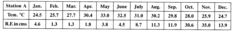
Study the table given above and answer the following questions:
(a) Calculate the average temperature of this place.
(b) Which are the rainiest month and the driest month of this station?
(c) What is the range of temperature of this station?
(d) What type of climate does the place have and why?
Answer:
(a) 28.6° C
(b) November is the rainiest month. February and March are the driest months.
(c) Range of Temperature is (33.0 – 24.5) = 8.5°C.
(d) The respective station has a maritime climate because there is not much difference between the highest and lowest temperature of the year. In other words it has an equable climate.
Question 67.
Explain any five factors that affect the climate of India.
Answer:
(a ) Pressure: In winter the pressure is high over the land and low over the sea. Therefore cold winds blow from land to the sea. In summer the winds blow from sea to land where the pressure is low.
(b) Distance from the Sea: Places near the sea have a moderate climate due to the influence of land and sea breezes. Places far away in the interior have a continental or extreme climate.
(c) Ocean Currents: Ocean currents affect the coastal regions. Cold currents reduce the temperature of the regions they blow along. Warm currents increase the temperature of coastal regions.
(d) Relief: Mountains lying at right angles to the winds cause heavy rainfall whereas mountains lying parallel to the winds do not cause rain. Windward slopes of mountains cause heavier rain than the leeward slope or the rain shadow area.
(e) Latitude: Due to the spherical shape of the earth the amount of solar energy received by the earth varies according to the latitude. Temperature decreases from the Equator to the poles.
Question 68.
Describe the path of the monsoon winds, after it strikes the West Bengal coast.
Answer:
(a) The Bay of Bengal Branch first strikes the coast of Bangladesh and then proceeds towards Assam in the first week of June.
(b) The high mountains cause the monsoon winds to deflect towards the west over the Ganga plains.
(c) The rainfall keeps on decreasing as the winds move up the Ganga Valley.
(d) By mid-June, the Arabian Sea Branch meets the Bay of Bengal Branch.
(e) The monsoon reaches Delhi by 29th June. Uttar Pradesh, Punjab, Haryana and eastern Rajasthan receives rain by the 1st week of July and Himachal Pradesh by mid-July.
Question 69.
Explain the distribution of rain caused by the Monsoons.
Answer:
(a) Heavy rainfall (over 250 cm) is caused on the windward slopes of the Western Ghats.
(b) The Deccan plateau and parts of Madhya Pradesh lie in the rain shadow area of the Ghats and get less rain.
(c) The north eastern part of the country receives very heavy rain (Mawsynram receives the highest rainfall in the world).
(d) Rain in the Ganga plain decreases from the east to the west.
(e) Rajasthan and parts of Gujarat get scanty rainfall.
Question 70.
Explain the four features of the Monsoon rains. [CBSE 2010]
Answer:
(a) The Monsoon is often irregular in its arrival and retreat.
(b) The rainfall is unevenly distributed. Certain regions lying on the windward slopes of the mountains receive heavy rain while those in the rain shadow area receives less.
(c) The amount of rain varies annually.
(d) The rainfall is concentrated within the three months of the year.
(e) The alternation of dry and wet spells vary in intensity. At one place the rainfall is very heavy
causing floods while at another place it might have famines. (any four)
Question 71.
Describe the regional variations in the climatic conditions of India with the help of suitable examples. [CBSE 2016]
Answer:
There are great variations in the climate of India.
(a) Certain regions receive very heavy rainfall like the North-east and the Western Coastal plains while others like the Thar Desert receive scanty rainfall.
(b) Places like Ladakh and Kashmir are very cold while others like Rajasthan are very hot.
(c) Coastal regions have an equable climate while places in the interior have an extreme climate.
(d) Areas on the windward slopes of the mountains receive heavy rainfall, while leeward and rain shadow areas receives less rain.
(e) Coastal areas with warm currents flowing past it, will be warmer than those areas which have the cold currents flowing close to it.
Question 72.
Describe the role of El Nino and Southern Oscillation to control the climate of India. [CBSE 2016]
Answer:
The periodic change in pressure conditions in eastern Pacific and eastern Indian Ocean is known as the Southern Oscillation. The difference in pressure’in the Indian arid Pacific Oceans is computed to predict the intensity of the monsoons. Negative pressure differences predict below average and late Monsoons. This affects the El Nino, a warm current which flows along the Peruvian current instead of the cold current. The changes in pressure conditions are connected to the EL Nino.
Question 73.
Why is the distribution of rainfall uneven in India? Mention any five factors? [CBSE 2011]
Answer:
The distribution of rainfall is uneven in India because:
(a) Relief: The Western Ghats receives heavy rainfall. The Arabian sea branch of the South-West monsoon, which are moisture laden winds, causes very heavy rainfall when they strike the Western Ghats. Mawsynram gets more rain due to its relief. It gets rain from the Bay of Bengal branch of the South-West monsoon.
(b) Distance from the Sea: Places near the coastal region get more rainfall than the places situated far away from the sea.
(c) Direction of the Winds: Rajasthan get scanty rainfall due to Arabian sea Branch blowing parallel to the Aravalli hills.
(d) Inter-Tropical Convergence Zone (ITCZ): It is also known as monsoon trough during the monsoon season. The trough and its axis keep on shifting, northward or southward, which determines the spatial distribution of rainfall. When the trough lies over the plains, rainfall is over this region. When the axis shift closer to the Himalayas, there is a dry spell over the plains and widespread rainfall in mountainous catchment area.
(e) Cyclonic disturbances: The occurrence of cyclonic depressions, which originate over Andaman Sea, generally cross the eastern coasts of India cause heavy and widespread rain in deltas of the Godavari, the Krishna and the Kaveri, coasts of Odisha and West Bengal.
Question 74.
Differentiate between the North-East Monsoons and South-West Monsoons by explaining five distinctive features of each.
Answer:
| South-West Monsoons | North-East Monsoons |
| They blow in summer from June to September. | They blow in winter from December to February. |
| They blow from (high pressure) sea to (low pressure) land. | They blow from (high pressure) land to (low pressure) sea. |
| They are moisture bearing winds. | These are dry as they originate over land. |
| They blow in two branches Arabian Sea Branch, Bay of Bengal branch and give bulk of rainfall to India from 75% to 90%. | While crossing the Bay of Bengal, they pick up moisture and give rainfall to the Coromandel coast (Tamil Nadu.) |
| High temperature, low pressure and high humidity | Low temperature, high pressure, low humidity. |
Question 75.
| Station A | Latitude | Altitude |
| A | 12 degree N | 909 m |
| B | 26 degree N | 160 m |
Study the table given above and answer the following questions:
(a) What type of climate does station A have and why?
(b) What type of climate does station B have and why? [CBSE 2016]
Answer:
(a)Since station A is located closer to the equator and at a height bf 909 metres it has a moderate climate.
(b) Station B is located at 26°N in the interior of the country, north of the Tropic of Cancer.
Question 76.
Development of tropical cyclones is a distinguishing feature of the monsoon. How do tropical cyclones influence distribution of rainfall in India? [CBSE 2016]
Answer:
The low pressure conditions over north western India slowly get transferred to the Bay of Bengal by early November. The occurrence of cyclonic depression is a result of this shift. The tropical cyclones move westwards towards the east coast of India and cause heavy rainfall there. These cyclones are very destructive and cause great damage to life and property. Most of the winter rain along the east coast is caused by these depressions.
Map Skills
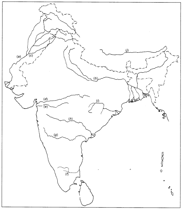
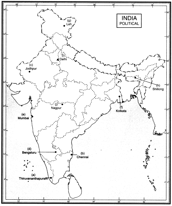
Question 77.
On the outline map of India, locate and label the following cities.
(a) Thiruvananthapuram
(b) Chennai
(c) Jodhpur
(d) Bengaluru
(e) Mumbai
(f) Kolkata
(g) Leh
(h) Sehillong
(i) Delhi
(j) Nagpur
Answer:
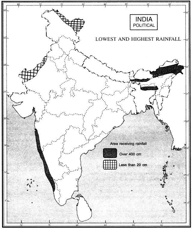
Question 78.
Two features are marked on the outline map of India. Identify the features on the basis of information provided and mark them.
(a) Area receiving rainfall less than 20 cm
(b) Area receiving rainfall more than 400 cm.
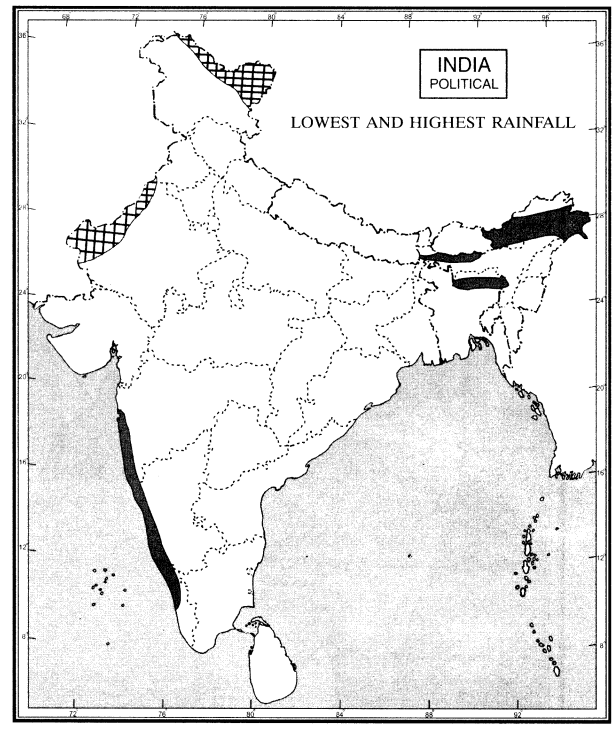
Answer:
We hope the given CBSE Class 9 Geography Chapter 4 Extra Questions Climate Pdf free download will help you. If you have any query regarding NCERT Extra Questions for Class 9 Social Science SST Geography Chapter 4 Climate, drop a comment below and we will get back to you at the earliest.