CBSE Class 9 Geography Chapter 3 Extra Questions Drainage Pdf free download are part of Extra Questions for Class 9 Social Science. Here we have given NCERT Extra Questions for Class 9 Social Science SST Geography Chapter 3 Drainage.
You can also practice NCERT Solutions for Class 9 Geography Chapter 3 Questions and Answers on LearnInsta.com.
NCERT Class 9 Geography Chapter 3 Extra Questions and Answers Drainage
Very Short Answer Type Questions
Question 1.
What is a river/drainage basin?
Answer:
A river/drainage basin is an area drained by a single river system.
Question 2.
What is a watershed?
Answer:
An upland/highland area that separates two drainage basin systems.
Question 3.
Which river has the largest basin in India?
Answer:
River Ganga has the largest basin in India.
Question 4.
In which two major groups Indian rivers are divided into?
Answer:
The Indian rivers are divided into:
(a) The Himalayan rivers
(b) The Peninsular rivers
Question 5.
What is a perennial river?
Answer:
Perennial rivers have water throughout the year. These rivers get water from rain and snow e.g. River Ganga.
Question 6.
What is a gorge?
Answer:
A gorge is a deep narrow channel created by a flowing river.
Question 7.
What do Himalayan rivers do in their upper course?
Answer:
The Himalayan rivers perform intensive erosional activity in their upper course and carry huge loads of silt and sand.
Question 8.
List the factors on which the drainage patterns depend. [HOTS]
Answer:
The slope of the land, the rock structure as well as the climatic conditions of the area are some factors on which the drainage pattern depends.
Question 9.
How is the dendritic pattern formed by the river?
Answer:
The dendritic pattern is formed by the river channel, when the river follows the slope of the land. The stream with its tributaries develops a pattern that resembles the branches of a tree so named as dendritic.
Question 10.
How does a rectangular pattern of drainage develop?
Answer:
Rectangular pattern of drainage develops on a strongly jointed rocky’ terrain.
Question 11.
How does a radial pattern of drainage develop?
Answer:
Radial pattern develops when streams flow in different directions from a central peak/dome.
Question 12.
Why are peninsular rivers called seasonal?
Answer:
The peninsular rivers are called seasonal because their flow depends upon rainfall. Even large rivers like the Narmada have less water during the dry season.
Question 13.
Where do most of the peninsular rivers originate? Where do they flow?
Answer:
Most of the peninsular rivers originate from the Western Ghats and they flow into the Bay of Bengal.
Question 14.
Name three main Himalayan river systems.
Answer:
The three main Himalayan river systems are the Indus system, the Ganga system and the Brahmaputra system.
Question 15.
Mention any two features of the Himalayan rivers.
Answer:
The two features of the Himalayan rivers are:
(a) The Himalayan rivers are long.
(b) They are joined by many large and important tributaries.
Question 16.
What is a river system?
Answer:
A river alongwith its tributaries may be called a river system.
Question 17.
Where does the Indus river originate?
Answer:
The Indus river originates in Tibet, near lake Mansarowar.
Question 18.
Name the tributaries which join Indus river in Kashmir.
Answer:
The Zaskar, the Nubra, the Hunza and the Shyok are the tributaries which join Indus river in Kashmir.
Question 19.
Which are the main tributaries of River Indus?
Answer:
The Satluj, the Ravi, the Beas, the Chenab and the Jhelum are the main tributaries of River Indus.
Question 20.
In which sea River Indus falls into?
Answer:
River Indus flows into the Arabian Sea.
Question 21.
What is the total length of River Indus?
Answer:
The total length of river Indus is 2900 km.
Question 22.
Write the regulations mentioned in Indus Water TVeaty of 1960?
Answer:
According to the regulations of the Indus Water Treaty of 1960, India can use only 20% of the total water carried by the Indus river system.
Question 23.
From which place does the River Ganga originate?
Answer:
The headwaters of the Ganga called the Bhagirathi is fed by Gangotri Glacier and joined by Alaknanda at Devaprayag in Uttarakhand.
Question 24.
Name the main tributaries of River Ganga.
Answer:
The Yamuna, the Ghaghara, the Gandak and the Kosi are the main tributaries of River Ganga.
Question 25.
From which place does Yamuna river originate?
Answer:
River Yamuna originates from Yamunotri glacier. Being a right bank tributary of Ganga river. It joins Ganga river at Allahabad.
Question 26.
Mention the journey/river drainage of River Yamuna.
Answer:
Starting from the Yamunotri glacier, it flows parallel to the Ganga and as a right bank tributary, meets the Ganga at Allahabad.
Question 27.
Which rivers rise from Nepal Himalayas?
Answer:
The Ghaghara, the Gandak and the Kosi rise in the Nepal Himalayas.
Question 28.
Mention the distinguished features about the Ghaghara, the Gandak and the Kosi river.
Answer:
(a) These rivers flood the northern plains every year.
(b) They enrich the soil for agricultural use.
Question 29.
Which tributaries join Ganga from peninsular uplands?
Answer:
The Chambal, the Betwa and the Son join the Ganga from the peninsular uplands.
Question 30.
What is the main feature of the tributaries of Ganga joining from the peninsula?
Answer:
These tributaries rise from semi-arid areas with shorter courses and do not carry much water.
Question 31.
What is the Namami Gauge Programme?
Answer:
It is an Integrated Conservation Mission approved as a ‘flagship programme’ by the Union Government in June 2014.
Question 32.
List the twin objectives of Namami Gauge Programme.
Answer:
Abatement of pollution, conservation and rejuvenation of the national river Ganga.
Question 33.
Where is the northernmost point of the Ganga delta?
Answer:
The northernmost point of the Ganga delta is in Farakka, West Bengal.
Question 34.
Where did Ganga river named as Meghna?
Answer:
After joining Brahamputra river, Ganga river named as Meghna.
Question 35.
How is Sundarban delta formed?
Answer:
The waters of two very big rivers i.e. the Ganga and the Brahmaputra flows into the Bay of Bengal and the delta formed by these rivers is known as Sundarban delta. It is the world’s largest and . fastest growing delta.
Question 36.
How is the Sundarban delta named?
Answer:
The Sundarban delta gets its name from the Sundari trees which grow very well in the marshland and does not get rot in water.
Question 37.
What is the total length of the River Ganga?
Answer:
The total length of the River Ganga is over 2500 km.
Question 38.
Which place is located on water divide of river Ganga and river Indus?
Answer:
Plains of Ambala is located on water divide of the Ganga and Indus river.
Question 39.
How does River Ganga forms large meanders?
Answer:
The plains from Ambala to the Sunderban stretch over nearly 1800 km, but the fall in its slope is hardly 300 metres there is a fall of one metre for every 6 km. Thus the river develops large meanders.
Question 40.
From where does Brahmaputra river originate?
Answer:
The Brahmaputra river originates in Tibet, east of Mansarowar lake very close to the sources of the Indus and the Satluj.
Question 41.
From where Brahmaputra river enters India?
Answer:
On reaching the Namcha Barwa (7757m), it takes a U-turn and enters India in Arunachal Pradesh through gorge.
Question 42.
When did Brahmaputra river known as Dihang?
Answer:
When Brahmaputra river enters India, it is known as Dihang.
Question 43.
What is Brahmaputra called in Tibet and Bangladesh?
Answer:
Brahmaputra called as Tsang Po in Tibet and Jamuna in Bangladesh.
Question 44.
Why does River Brahmaputra carry less water and silt in Tibet?
Answer:
In Tibet, River Brahmaputra carry less water and silt as it is a dry and cold area.
Question 45.
Give one feature of River Brahmaputra.
Answer:
The Brahmaputra river is a braided channel in its entire length in Assam and forms many riverine islands, e.g. Majuli in Brahmaputra, is the largest inhabited riverine island in the world.
Question 46.
Mention the cause behind widespread devastation caused by Brahmaputra river.
Answer:
Due to floods in Assam and Bangladesh during rainy season, every year Brahmaputra river overflows its banks and cause widespread devastation.
Question 47.
How is Brahmaputra river different from other north Indian rivers?
Answer:
Unlike other north Indian rivers, the Brahmaputra river got huge deposits of silt on its bed which results in rising of river bed. The river also shifts its channel frequently.
Question 48.
Name the main water divide in Peninsular India.
Answer:
The main water divide in Peninsular India is formed by the Western Ghats.
Question 49.
Name the major peninsular rivers of India.
Answer:
The Mahanadi, the Godavari, the Krishna and the Kaveri are the major peninsular rivers in India.
Question 50.
Name the peninsular rivers flowing westwards and also make estuaries.
Answer:
The Narmada and the Tapi are the peninsular rivers flow westwards and also make estuaries.
Question 51.
From which place Narmada river rises?
Answer:
The Narmada river rises in Amarkantak hills in Madhya Pradesh.
Question 52.
Mention some picturesque location of Narmada river when the Narmada river flows through.
Answer:
The Marbel rocks near Jabalpur and the Dhuadhar falls form picturesque location
Question 53.
Name the scheme undertaken by the government of Madhya Pradesh for the Narmada river conservation mission.
Answer:
Namami Devi Narmade.
Question 54.
In which Indian states Narmada basin formed?
Answer:
Narmada basin formed in Madhya Pradesh and Gujarat.
Question 55.
Where does the River Tapi rises?
Answer:
The River Tapi rises in Satpura ranges in the Betul district of Madhya Pradesh.
Question 56.
Name the Indian states which covers parts of Tapi basin.
Answer:
Madhya Pradesh, Gujarat and Maharashtra are the states which covers the Tapi basin.
Question 57.
Why coastal rivers are short in length?
Answer:
Coastal rivers are short in length because the coastal plains between the Western Ghats and the Arabian Sea are very narrow.
Question 58.
Name the major west-flowing rivers of the W’estern Ghats.
Answer:
Sabarmati, Mahi, Bharathpuzha and Periyar are the major west flowing rivers of the Western Ghats.
Question 59.
Which is the largest Peninsular river?
Answer:
River Godavari is the largest Peninsular river.
Question 60.
Where does the River Godavari rise?
Answer:
The River Godavari rises from the slopes of the Western Ghat in the Nasik district of Maharashtra.
Question 61.
Which drainage basin largest among Peninsular rivers?
Answer:
Godavari drainage basin is largest among the Peninsular rivers.
Question 62.
Name the tributaries of River Godavari.
Answer:
The Purna, the Wardha, the Pranhita, the Manjra, the Wainganga and the Penganga are the tributaries of River Godavari.
Question 63.
Which river is known as Dakshin Ganga?
Answer:
Godavari river is known as Dakshin Ganga.
Question 64.
From where does the Mahanadi river rises?
Answer:
Mahanadi river rises in the highlands of Chhattisgarh.
Question 65.
Write the total length of Mahanadi river? Which Indian states have Mahanadi river basin?
Answer:
The total length of river is 860 km. Maharashtra, Chhattisgarh, Jharkhand and Odisha have Mahandi river basin.
Question 66.
From which region River Krishna rises?
Answer:
River Krishna rises from a spring near Mahabaleshwar.
Question 67.
Mention the length of Krishna river. In which waterbody it falls into?
Answer:
The total length of Krishna river is 1400 km and it falls into the Bay of Bengal.
Question 68.
Name the major tributaries of River Krishna.
Answer:
The Tungabhadra, the Koyana, the Ghatprabha, the Musi and the Bhima are the major tributaries of River Krishna.
Question 69.
Which Indian states share the basin of Krishna river?
Answer:
Maharashtra, Karnataka and Andhra Pradesh are the Indian states which shared the Krishna basin.
Question 70.
Write the main tributaries of Kaveri river. Also mention its total length.
Answer:
Kaveri basin’s main tributaries are Amravati, Bhavani, Hemavati and Kabini. Its total length is 760 km.
Question 71.
Name the Indian states which have Kaveri basin.
Answer:
Karnataka, Kerala and Tamil Nadu have the Kaveri basin.
Question 72.
Name the second biggest waterfall in India which is made by River Kaveri.
Answer:
The second biggest waterfall in India which is made by River Kaveri is Jog Falls, it is used to generate hydroelectricity.
Question 73.
Name the biggest waterfall in India.
Answer:
Kunchikal falls (1493 feet/455 mts)
Question 74.
Mention the composition of water on earth’s surface.
Answer:
71% of the earth’s surface is covered with water. 97% of it is salt water and only 3% is in the form of fresh water in rivers, lakes, ponds, glaciers and ice caps.
Question 75.
How are oxbow lakes formed?
Answer:
A meandering river cuts across the narrow neck of the meander forming an oxbow lake.
Question 76.
How lakes become seasonal?
Answer:
Lakes in the region of inland drainage are sometime seasonal, e.g. Sambhar lake of Rajasthan.
Question 77.
What are fresh water lakes?
Answer:
Fresh water lakes are mostly found in the Himalayan region. These are usually formed by a glacier and get filled with water by melting snow.
Question 78.
Name some fresh water lakes of India.
Answer:
The Wular, Dal, Bhimtal, Nainital, Loktak and Barapani are some fresh water lakes.
Question 79.
How are man-made lakes formed?
Answer:
Man-made lakes are formed when the rivers are used for generation of hydro-electricity by constructing a dam across a river. e.g. Guru Gobind Sagar lake (Bhakra Nangal Dam Project).
Question 80.
Give the full form of GAP & NRCP.
Answer:
GAP is Ganga Action Plan and NRCP is National River Conservation Plan.
Question 81.
When was the Ganga Action Plan launched?
Answer:
1985.
Question 82.
Under which plan the Ganga Action Plan was expanded to cover other rivers in 1995?
Answer:
National River Conservation Plan.
Question 83.
What is the objective of the NRCP?
Answer:
To improve the water quality of the rivers through the implementation of pollution abatement work.
Short Answer Type Questions
Question 84.
Explain any three features of Peninsular rivers. [CBSE 2012]
Answer:
The three features of the Peninsular rivers are:
(a) A large number of peninsular rivers are seasonal as they are dependent on rainfall.
(b) They have short and shallow courses.
(c) Most of the peninsular rivers originate from the Western Ghats and flow into the Bay of Bengal.
(d) The drainage basin of Peninsular rivers are small in size. (any three)
Question 85.
Why are Peninsular rivers seasonal in nature? State any three reaSons. [CBSE 2014]
Answer:
The three reasons are as follows:
(a) The Peninsular rivers are dependent on rainfall unlike the Himalayan rivers are snowfed.
(b) The hills of the peninsular plateau are not snow-bound unlike Himalayas.
(c) These rivers follow smaller course and have small basins which influence water volume.
(d) The catchment areas (the area where the river gets maximum water either by rain/snow) of peninsular rivers are small in comparison to Himalayan rivers.
Question 86.
Which two rivers form the largest delta? Write any two features of this delta. [CBSE 2014]
Answer:
River Ganga and River Brahmaputra from the largest delta i.e. the Sundarban delta.
The two features of this delta are:
(a) It is the largest and fastest growing delta in the world.
(b) It gets its name as Sundarban from the Sundari tree. It is the home of the Royal Bengal tiger.
Question 87.
Compare a delta and an Estuary. [CBSE 2010]
Answer:
| Delta | Estuary |
| (a) It is a triangular-shaped alluvial landmass formed at the mouth of the river. | (a) Deep funnel-shaped valleys at the mouth of a river where the sea water and the river water meets. It is free from any deposits. |
| (b) Delta is formed in regions of low tides by a dense network of distributaries in the coastal areas. | (b) Estuaries are formed in areas of high tides and rift valleys. |
| (c) The delta areas have fertile soils which get renewed annually. | (c) These are the best fishing grounds of the world. |
| e.g. Sundarban delta in India and Bangladesh. | e.g. Estuaries of the Narmada and Tapi river. |
Question 88.
Explain the concept of water divide with special reference for Ganga and Indus river systems. Name the major distributary of river Ganga. [CBSE 2014]
Answer:
(a) A water divide is a highland area/an upland/mountain which separates two drainage basins.
(b) Ambala is located on the water divide between the Indus and the Ganga river system.
(c) The distributary of River Ganga are Hooghly.
Question 89.
Why are most of the Peninsular river draining into the Bay of Bengal? Give two reasons. Name two rivers draining into the Arabian Sea. [CBSE 2014]
Answer:
I. Most of the Peninsular rivers drain into the Bay of Bengal because of the following reasons:
(a) The Eastern Ghats are lower than the Western Ghats and are also discontinuous thus making it easier for the rivers to reach the Bay of Bengal.
(b) The Deccan Plateau has a gentle slope towards the east, thus the rivers drain towards the east.
II. Two rivers draining into the Arabian Sea are the Narmada and the Tapi.
Question 90.
Describe three important features of the Tapi basin.
Answer:
The important features of Tapi basin are:
(a) The Tapi river rises in the Satpura ranges in the Betul district of Madhya Pradesh.
(b) It also flows through a rift valley parallel to the Narmada but much shorter in length.
(c) Its basin covers parts of Madhya Pradesh, Gujarat and Maharashtra.
Question 91.
Why are the rivers of Western Coast very short?
Answer:
The rivers of West Coast of India are very short because:
(a) The coastal plains between Western Ghats and the Arabian Sea are very narrow.
(b) The course of these rivers are short as they do not have much water and drain small area of the states.
(c) These rivers are seasonal in nature.
Examples of these rivers are Sabarmati that drains parts of Rajasthan and Gujarat; Mahi – Madhya Pradesh, Rajasthan, Gujarat; Periyar – Kerala, Bharathpuzha – Kerala.
Question 92.
Describe any three important features of the Mahanadi basin. [CBSE 2015]
Answer:
The three important features of Mahanadi basin are:
(a) Mahanadi basin covers parts of the states of Chhattisgarh, Jharkhand, Odisha and Maharashtra.
(b) It rises in the highlands of Chhattisgarh and flows through Odisha to form a delta in the Bay of Bengal. It’s length is 860 km.
(c) Due to the devastating floods that the river causes every year, the Hirakund dam has been built on it.
Question 93.
From where does the River Krishna originate? Name its tributaries. Mention the names of the states covered by it.
Answer:
(a) The River Krishna rises from a spring near Mahabaleshwar.
(b) Its tributaries are the Tungabhadra, the Koyana, the Ghatprabha, the Musi and the Bhima.
(c) The states covered by Krishna river are Maharashtra, Karnataka and Andhra Pradesh.
Question 94.
What is the difference between a Tributary and Distributary? [CBSE 2015]
Answer:
| Tributary | Distributary |
| (a) A small stream which joins the main river. | (a) A branch of main river which leaves the main river before it reaches the sea. |
| (b) It adds water to the main river. | (b) It takes away the water of the main river and adds it to the sea. |
| (c) Main river gains water and becomes an active agent of gradation. | (c) The river becomes sluggish when the distributary leaves it. |
| (d) e.g. Yamuna, Ghaghara, Gandak and Kosi are tributaries of Ganga river. | (d) e.g. Hooghly is a distributary of Ganga.(any three) |
Question 95.
(a) How are the Fresh Water lakes formed in the Himalayas? Give two examples of fresh water lakes in this region.
(b) How is the Sambhar lake useful? [HOTS]
Answer:
(a) (i) Most of the fresh water lakes are in the Himalayan region are of glacial origin i.e. they are
formed when a glacier digs out a basin that is later filled with water from snow melt or rain. Some examples of fresh water lakes are Bhimtal, Nainital, Dal lake etc.
(ii) India’s largest fresh water lake is Wular Lake which is an exception as it was formed by tectonic activity.
(b) Sambhar lake in Rajasthan is a rich source of salt in India.
Long Answer Type Questions
Question 96.
What is a river pattern? Name any four patterns formed by the rivers. [CBSE 2014,15]
Answer:
The streams within the drainage basin form certain patterns depending on
(a) the slope of the land
(b) underlying rock structure of the area
(c) the climate of the area.
The different drainage patterns are:
(a) Dendritic Pattern: It develops where the river channel follows the slope of the land. When the stream and its tributaries drainage pattern resembles the branches of a tree, so it is called dendritic.
(b) Trellis Pattern: This pattern develops when a river is joined by its tributaries at approximately right angles. It also develops when the hard and soft rocks exist parallel to each other.
(c) Rectangular Pattern: This drainage pattern develops on a strongly jointed rocks terrain.
(d) Radial Pattern: The drainage pattern develops when streams flow in different directions from a central peak or dome-like structure.
Question 97.
Write main features of River Indus under the following headings: [HOTS]
(a) Source
(b) Tributaries
(c) Areas drained
(d) Extent of Indus Plain
(e) Indus Water Treaty.
Answer:
The main features of River Indus as an important river of the Himalayas are:
(a) Source: Indus river rises in Tibet, near lake Mansarowar. While flowing towards west it enters India in the Ladakh district of Jammu and Kashmir by forming a picturesque gorge.
(b) Tributaries: Several tributaries like the Zaskar, the Nubra, the Shyok and the Hunza join it in the Kashmir region. Other major tributaries are the Satluj, the Beas, the Ravi, the Chenab and the Jhelum join together and form Indus at Mithankot in Pakistan.
(c) Areas drained by river Indus: The Indus flows southwards eventually reaching the Arabian Sea east of Karachi areas. This is where Indus river end but not the total area drained.
(d) Extent of the Indus Plain: The Indus plain has a gentle slope. It covers the states of Jammu and Kashmir, Himachal Pradesh and Punjab.
(e) Indus Water Treaty (1960): According to the regulations of this treaty, India can use only 20% of the total water carried by Indus river system. The water is used for irrigation in Punjab, Haryana and southern and western parts of Rajasthan.
Question 98.
Give main characteristic features of the Ganga river system. [HOTS]
Answer:
The main characteristic features of the Ganga river system are:
(a) The Ganga rises in Gangotri Glacier in Uttarakhand. Its headstream Bhagirathi joined by the Alaknanda at Devaprayag in Uttarakhand.
(b) At Haridwar, the river Ganga comes out from the mountains to the plains.
(c) Its tributaries like the Yamuna, the Gandak, the Ghaghara, the Kosi flood parts of northern plains every year, causing widespread damage to life and property but the flood enriches the soil naturally. The soil is most suitable for intensive cultivation.
(d) The main tributaries that join Ganga river from peninsular India are the Chambal, the Betwa and the Son.
(e) The Ganga continues to flow eastwards after addition of water by its tributaries till Farakka in West Bengal. It then enters Bangladesh and joined Brahamputra and known as stream Meghna which flows into the Bay of Bengal. Here, it forms the Sundarban delta, which is the largest delta of the world.
Question 99.
Give characteristic features of the Ganga-Brahmaputra delta.
Answer:
The characteristic features of the Ganga-Brahmaputra delta are:
(a) The Ganga-Brahmaputra delta is also known as Ganga delta or Sundarban delta.
(b) It is situated in Bangladesh (southern parts) and in the state of West Bengal (India).
(c) It is the world’s largest and fastest growing delta.
(d) The mainstream of Ganga river flows southwards into Bangladesh and is joined by the Brahmaputra river resulting in the formation of a delta.
(e) Sundarban delta derived its name from Sundari trees which does not rot in stagnant water.
(f) It is also the home of Royal Bengal tigers.
Question 100.
Give the main characteristic features of mighty Brahmaputra river. [HOTS]
Answer:
The main characteristics features of Brahmaputra river are:
(a) Its source lies in Tibet, east of Mansarowar lake very close to the sources of the Indus and the Satluj. It is slightly longer than the Indus and most of its course lies outside India.
(b) The river carries less silt and smaller volume of water in Tibet as it is a cold and dry area,
(c) Brahmaputra river passes through a region of high rainfall in India. Hence, the river carries large volume of water and considerable amount of silt.
(d) The Brahmaputra has a braided channel in its entire length in Assam and forms many riverine islands. For example, Majuli island is the largest inhabited riverine island in the world.
(e) Unlike other rivers of north India, river Brahmaputra is marked by huge deposits of silt on its bed causing the river bed to rise. The river also shifts its channel frequently. Every year during the rainy season the river overflows its banks causing widespread devastation due to floods in Assam and Bangladesh.
Question 101.
Enlist the characteristic features of the Godavari basin.
Answer:
The characteristic features of the Godavari basin are as follows:
(a) It is the largest river basin of the Peninsular rivers.
(b) It rises in the Nasik district of Maharashtra and joins the Bay of Bengal in Andhra Pradesh.
(c) The Godavari river basin covers the states of Maharashtra, Madhya Pradesh, Odisha and Andhra Pradesh (50% of this basin covers the state of Maharashtra).
(d) The Godavari is often referred to Dakshin Ganga because of its largest size and extent.
(e) The important tributaries of River Godavari are: the Purna, the Wardha, the Pranhita, the Manjra, the Wainganga and the Penganga.
Question 102.
What is meant by drainage? Explain any four benefits of rivers. [CBSE 2014]
Answer:
(a) Drainage means river system of an area.
(b) The four benefits of rivers are:
(i) The rivers provide water, the basic natural resource essential for various human activities.
(ii) The banks of the rivers have always attracted settlers from ancient times. These settlements are now big cities.
(iii) River waters are used for irrigation, navigation, hydro-electric power generation is of special significance.
(iv) Rivers are very significant for countries like India where agriculture is the livelihood of the majority of the population.
Question 103.
What are the causes of river pollution? How can it be prevented?
Answer:
River pollution are caused by the following ways.
(a) Rivers are polluted by domestic, municipal, industrial and agricultural waste. This affects the quality of water.
(b) Large amount of untreated sewage are dumped into the rivers. This affects the self cleansing capacity of water.
(c) Increasing pollution by urbanisation and industrialisation also contribute to river pollution which has increased to very high levels.
River pollution can be prevented by:
(a) Treatment of industrial and urban waste before it is dumped into the rivers.
(b) Sensatising the people about pollution of rivers and difficulties in cleaning water.
(c) Various action plans like Ganga Action Plan to clean up River Ganga.
(d) Emphasising on the technologies used to reduce river pollution by promoting recycling of water, improvement of water quality.
MAP SKILLS
Question 104.
Some features are marked in the given political map of India. Identify these features with the help of given information and write their correct names on the lines marked on the map.
- Type of Rivers
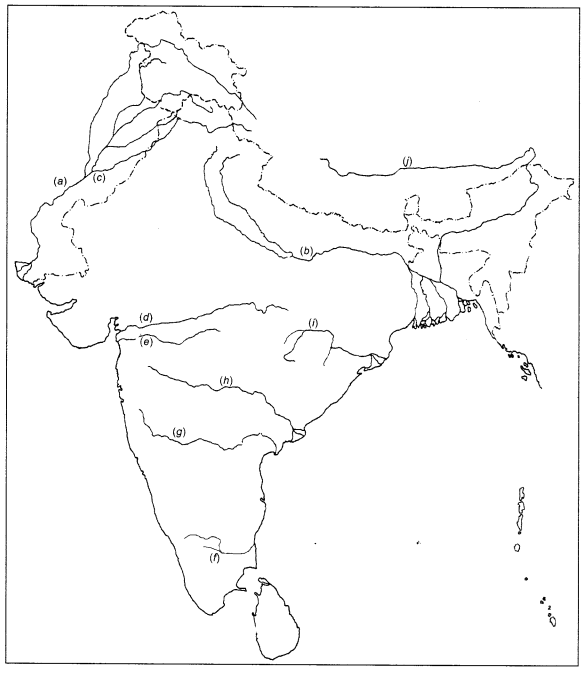
Answer:
(a) The Indus
(b) The Ganges
(c) The Satluj
(d) The Narmada
(e) The Tapi
(f) The Kaveri
(g) The Krishna
(h) The Godavari
(i) The Mahanadi
(j) The Brahmaputra
Question 105.
Some features are marked in the given outline political map of India. Identify these features with the help of given information with their correct names on the sign marked on the map.
- Type of Lakes
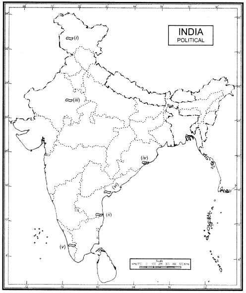
Answer:
(i) Wular Lake
(ii) Pulicat Lake
(iii) Sambhar Lake
(iv) Chilika Lake
(v) Vembanad Lake
(vi) Kolleru Lake
We hope the given CBSE Class 9 Geography Chapter 3 Extra Questions Drainage Pdf free download will help you. If you have any query regarding NCERT Extra Questions for Class 9 Social Science SST Geography Chapter 3 Drainage, drop a comment below and we will get back to you at the earliest.