CBSE Class 9 Geography Chapter 2 Extra Questions Physical Features of India Pdf free download are part of Extra Questions for Class 9 Social Science. Here we have given NCERT Extra Questions for Class 9 Social Science SST Geography Chapter 2 Physical Features of India.
You can also practice NCERT Solutions for Class 9 Geography Chapter 2 Questions and Answers on LearnInsta.com.
Extra Questions for Class 9 Social Science Geography Chapter 2 Physical Features of India
Very Short Answer Type Questions
Question 1.
Mention one example of hard and soft rock with their use.
Answer:
Hard rock like marble has been used for making the Taj Mahal and soft rock like soap stone is used for making talcum powder.
Question 2.
Give the reason for variation of soil colour at different places.
Answer:
The reason for variation of soil colour is that the soil is formed out of different types of rocks.
Question 3.
Name the processes which have created and modified the relief to its present state.
Answer:
The processes are weathering, erosion and deposition.
Question 4.
What is the Theory of Plate Tectonics? [CBSE 2014]
Answer:
The Theory of Plate Tectonics states that the earth’s crust has been formed out of seven major and some minor plates. The movement of these plates results in folding, faulting and volcanic activity.
Question 5.
What happens when two tectonic plates collide with each other?
Answer:
When two plates collide with each other, it can lead to folding, faulting and volcanic activity.
Question 6.
Which are the three types of plate boundaries/movements? [HOTS]
Answer:
The three types of plate boundaries includes convergent, divergent and transform boundary.
Question 7.
Mention any six tectonic plates of the earth’s crust.
Answer:
The six tectonic plates of the earth’s crust are Eurasian plate, North American plate, South American plate, African plate, Indo-Australian plate and Pacific and Antarctic plate.
Question 8.
What is the implication of plate movements?
Answer:
The plate movements have changed the size and position of the continents over million years. These movements have also influenced the evolution of present landforms.
Question 9.
Where do most of volcanoes and earthquakes happen?
Answer:
Most of them are happened at plate margins but some also occur within the plates.
Question 10.
Name the oldest part of the Indian landmass.
Answer:
The peninsular plateau is the oldest landmass of India.
Question 11.
Which areas comprised the Gondwana land?
Answer:
The Gondwana land comprised of India, Australia, South Africa, South America and Antarctica.
Question 12.
Which two plates collided with each other when Gondwana land split?
Answer:
When Gondwana land split, the two plates which collided with each other were Indo-Australian and Eurasian plate.
Question 13.
From which type of boundary were Himalayas formed?
Answer:
The Himalayas have been formed by convergent boundaries.
Question 14.
Name the geosyncline which formed the mountain system of western Asia and Himalayas.
Answer:
The geosyncline was Tethys Sea.
Question 15.
Mention the division of super continent Pangea.
Answer:
The super continent was divided into two parts i.e. Angara land in north and Gondwana land in south.
Question 16.
What does the geology of the peninsular plateau show?
Answer:
The geology of the peninsular plateau shows that it constitutes one of the ancient landmasses on the earth’s surface. It was suppose to be one of the most stable blocks.
Question 17.
Mention any one feature of Northern Plains of India.
Answer:
The Northern plains of India are fertile alluvial plains formed by deposition of sediments by the rivers.
Question 18.
What is the composition of the peninsular plateau?
Answer:
It is composed of igneous and metamorphic rocks with gently rising hills and wide valleys.
Question 19.
Name the major physical divisions of India.
Answer:
The major physical divisions of India are the Himalayan mountains, the Northern plains, the Peninsular plateau, the Indian desert, the Coastal plains, the Islands.
Question 20.
What is the extent of Himalayas?
Answer:
The Himalayas stretch along the northern borders of India. The Himalayas spread out from Indus to Brahmaputra in a west-east direction.
Question 21.
In which part Himalayan altitudinal extent is greater?
Answer:
The eastern-half of Himalayas have greater altitudinal extent than western-half.
Question 22.
Name the three parallel ranges of the Himalayas.
Answer:
The three parallel ranges of the Himalayas are:
(a) The Great Himalayas or Inner Himalayas or Himadri
(b) Himachal or Lesser Himalayas
(c) Shiwaliks or Outer Himalayas.
Question 23.
Why is Himadri mountain range named so?
Answer:
Himadri in Sanskrit means the abode of snow and the range is perpetually snowbound.
Question 24.
Mention a characteristic feature of Himadri.
Answer:
Himadri is the most continuous range with an average height of 6000 metres and consists of loftiest peaks.
Question 25.
Name the states of India where highest peaks of Himalayas are located.
Answer:
Mountain Peak States
Kanchenjunga Sikkim
Nanga Parbat Jammu and Kashmir
Nanda Devi Uttarakhand
Kamet Uttarakhand
Namcha Barwa Arunachal Pradesh
Question 26.
Mention the location of Mussoorie, Nainital and Ranikhet in India.
Answer:
Mussoorie-Uttarakhand, Nainital-Uttarakhand, Ranikhet-Uttarakhand
Question 27.
What do you mean by Lesser Himalayas?
Answer:
Lesser Himalayas or Himachal are the mountain range located south of Himadri.
Question 28.
How do Himachal composed of?
Answer:
It is composed mainly of highly compressed and altered rocks.
Question 29.
Mention the height and width of Himachal.
Answer:
Himachal have height between 3700 to 4500 m and average width is of 50 km.
Question 30.
Name the three prominent sub-ranges of the Himachal Himalayas.
Answer:
The sub-ranges are the Pir Panjal, the Dhaula Dhar and the Mahabharat.
Question 31.
Name the famous valleys found in the Himachal Himalayas.
Answer:
The famous valleys found in the Himachal Himalayas are the valley of Kashmir, the Kangra and Kullu valley.
Question 32.
What is the average height of the Shiwaliks?
Answer:
The average height of the Shiwaliks is between 900 to 1100 m.
Question 33.
Why are Shiwaliks more prone to earthquakes and landslides? [HOTS]
Answer:
The Shiwaliks are more prone to earthquakes and landslides because they are made of unconsolidated mud, sediments and rocks.
Question 34.
What do you understand by Duns? Give example. [CBSE 2010]
Answer:
Duns are the longitudinal valleys lying between the lesser Himalayas and Shiwaliks e.g. Dehra Dun, Kotli Dun etc.
Question 35.
Name the longitudinal divisions of Himalayas:
(a) Between Indus and Satluj rivers.
(b) Between Kali and Tista rivers.
Answer:
(a) Between Indus and Satluj rivers the Himalayas’ division is known as the Punjab Himalayas or Kashmir and Himachal Himalayas.
(b) Between Kali and Teesta rivers, the Himalayas’ division is known as the Nepal Himalayas.
Question 36.
Name the two rivers between which Kumaon and Assam Himalayas demarcated.
Answer:
The Kumaon Himalayas is demarcated between the Satluj and the Kali river. The Assam Himalayas is demarcated between Tista and Dihang rivers.
Question 37.
What do you mean by Purvachal?
Answer:
Purvachal refers to sharp southward bent of Himalayas mountain beyond the Dihang gorge.
Question 38.
What is the location of the Purvachal?
Answer:
Purvachal lies along the eastern edge of India and forms the border with Myanmar.
Question 39.
How does the purvachal composed of?
Answer:
The Purvachal composed of strong sandstone i.e. sedimentary rocks.
Question 40.
Name the hills that make the Purvachal.
Answer:
The Patkai hills, Naga hills, Manipur hills and Mizo hills make the Purvachal.
Question 41.
Which physical feature of India is a flat land comprised of extensive alluvial deposits?
Answer:
The Northern plains is a flat land having extensive alluvial deposits from the rivers flowing in it.
Question 42.
Name the major river systems of the Northern plains.
Answer:
The three major river systems are the Indus, the Ganga and the Brahmaputra.
Question 43.
Mention the extent of Northern plains of India.
Answer:
The Northern plains of India spread over an area of 7 lakh sq. km. It has a length of 2400 km and breadth of 240 to 320 km.
Question 44.
Why does Northern plains considered as agriculturally productive part of India?
Answer:
The existence of rich soil cover combined with adequate water supply and favourable climate together make the northern plains agriculturally productive part of India.
Question 45.
How are riverine islands formed? Give an example.
Answer:
Riverine islands are formed by the rivers in their lower course. The rivers are involved in depositional work due to the gentle slope, low velocity and thus lead to the formation of a riverine island, e.g., Majuli island in Brahmaputra river (the largest inhabited riverine island in the world).
Question 46.
Explain the term distributary.
Answer:
In the lower course rivers split into numerous channels due to the deposition of the silt. These numerous channels known as distributaries. e.g. R. Hooghly is the distributary of R. Ganga.
Question 47.
Mention the division of northern plains.
Answer:
They are divided into three sections Punjab plains, Ganga plains and Brahmaputra plains according to the basis of rocks.
Question 48.
Which section of Northern plains are dominated by doabsl.
Answer:
Originating from Himalayas, the Indus river and its tributaries are dominated by doabs.
Question 49.
Mention the division of Northern plains on the basis of relief features.
Answer:
The division includes bhabar, terai, bhangar and khadar.
Question 50.
What do you mean by the term bhabar?
Answer:
After descending from the mountains, the river deposits pebbles in a narrow belt of about 8 to 16 km in width is known as bhabar. It lies parallel to the slopes of Shiwaliks.
Question 51.
What is the name given to the wet and swampy belt of the northern plains?
Answer:
The wet and swampy belt of the northern plains is known as terai.
Question 52.
What do we mean by the term bhangarl.
Answer:
Bhangar is the older alluvial soil region lying above the flood plains and presenting a terrace like feature. It forms the largest part of the Northern plains.
Question 53.
Write a feature of khadar.
Answer:
The newer younger deposits of flood plains, khadar is very fertile and ideal for intensive agriculture.
Question 54.
Give the composition of the peninsular plateau.
Answer:
The peninsular plateau is composed of the old crystalline, igneous and metamorphic rocks. They were formed by the breaking and drifting of Gondwana land.
Question 55.
Give two broad divisions of the peninsular plateau.
Answer:
The two broad divisions of the peninsular plateau are the Central Highlands and the Deccan Plateau.
Question 56.
Name the two mountain ranges by which the Vindhyan range is bounded on the south and on the northwest.
Answer:
The Vindhyan range is bounded by the Satpura range on the south and the Aravalis on the northwest.
Question 57.
What do you mean by bundelkhand and baghelkhandl.
Answer:
The eastward extensions of the Central Highland is known as bundelkhand and baghelkhand.
Question 58.
Mention the location of Deccan Plateau.
Answer:
Deccan Plateau is located in the south of the Narmada river. The Satpura range is in north while the Mahadev, the Kaimur hills and the Maikal range is its eastern extension.
Question 59.
Which two well-known rivers originate near the Mahadev hills?
Answer:
The rivers originating near the Mahadev hills are the Narmada and the Son.
Question 60.
List down the extension of Deccan Plateau in northeast.
Answer:
The extension are Meghalaya, Karbi-Anglong Plateau and North Cachar hills.
Question 61.
Name the highest peak of the Western Ghats.
Answer:
The Anai Mudi with the height of 2,695 m is the highest peak of the Western Ghats.
Question 62.
Which is the highest peak of the Eastern Ghats?
Answer:
The Mahendragiri with the height of 1,501 m is the highest peak of the Eastern Ghats.
Question 63.
Name the hills lies in the southeast of the Eastern Ghats.
Answer:
The Shevroy and Javadi hills lies in the southeast of the Eastern Ghats.
Question 64.
Mention one distinct feature of Peninsular plateau.
Answer:
The Deccan trap i.e. the black soil area is one of the distinct features of Peninsular Plateau.
Question 65.
How did the black soil form in Deccan TVap?
Answer:
In Deccan Trap, rocks are of volcanic origin, thus the type of rocks is igneous and these are denunded over time resulted in formation of black soil.
Question 66.
What is the location of Satpura range in comparison with the Aravali?
Answer:
The Satpura range lies to the south of the Aravali range.
Question 67.
Which is the only largest river in the Indian Desert?
Answer:
River Luni is the only largest river in the Indian desert.
Question 68.
What do you mean by Barchans? Where are they found?
Answer:
Crescent-shaped dunes are known as Barchans. They are found in the Indian desert prominently near the Indo-Pakistan boundary.
Question 69.
List down the location of the western coast.
Answer:
The western coast is a narrow plain sandwiched between the Western Ghats and the Arabian Sea.
Question 70.
Name the three divisions of the western coastal plains.
Answer:
The three divisions of western coastal plains are the Konkan, the Kannada and the Malabar.
Question 71.
On which coastal plain does the deltas of the Godavari, Mahandi, Krishna and Kaveri formed?
Answer:
On the eastern coastal plains, these deltas are formed.
Question 72.
What is the Chilika lake?
Answer:
It is a largest back water or salt water lake found in Odisha, south of the Mahanadi delta.
Question 73.
What was the earlier name of Lakshadweep?
Answer:
They were known as Laccadive, Minicoy and Amindive. In the year 1973 they were named as Lakshadweep.
Question 74.
Which island in the Lakshadweep islands group has a bird sanctuary?
Answer:
The bird sanctuary is located in the Pitti island.
Question 75.
In which habitat the coral polyps flourish?
Answer:
Coral polyps flourish in a habitat consisting of shallow warm water, which does not have mud. This kind of habitat is found in Lakshadweep islands.
Question 76.
Name the island groups which has an active volcano.
Answer:
An active volcano is found on Barren island in Andaman and Nicobar islands.
Question 77.
Which physical feature of India is known as granaries of the world?
Answer:
The Northern plains of India is known as granaries of the world.
Short Answer Type Questions
Question 78.
What are the three types of plate movements on the earth?
Answer:
The three types of plate movements are the following.
(a) Converging Boundary: When the plates come towards each other, they form convergent boundaries. ‘ The plates collide, crumble or even slide under the other. It may also be known as folding
movements. For example, Himalayas mountains were formed by convergence of IndoAustralian plate against Eurasian plate.
(b) Divergent Boundary: These are formed when the plates move away from each other, they form divergent boundary. They are also called faulting movements. For example, the North American Plate diverge from the Eurasian Plate.
(c) Transform Boundary: When some plates move past each other form transform boundary, i e.g. San Andreas fault. The western half of California is moving north because it is part of the Pacific Plate and Eastern half of California is moving south because it is part of North America.
Question 79.
Give a brief description of the Himalayan mountains.
Or
State any three features of Himalayan mountains. [CBSE 2013]
Answer:
The three features of Himalayan mountains are:
(a) Himalayas are geologically young as well as structurally fold mountains stretching along the northern borders of India.
(b) They run from west to east direction i.e. from River Indus to River Brahmaputra.
(c) They form an arc over a length of 2400 km. They are higher in the east than in the west. They are the loftiest rugged mountain range in the world.
Question 80.
Explain in brief the famous passes of the Himalayas.
Answer:
A pass is a natural pathway in between high mountains. The Himalayan mountains are so formidable that it is not possible to cross them. There are some passes in the Himalayas which provide route-way across them. Some of the important passes are:
(a) Shipki La located in Satluj valley in Himachal Pradesh along Tibet border.
(b) Lipu Lekh pass near Tibet border in Uttarakhand providing route to Mt. Kailash and Mansarowar in Tibet.
(c) In the east, there is Nathu La pass in Sikkim and China border providing passage from India to Lhasa and Bomdi la pass La Arunachal-China border.
Question 81.
List some major Mountain Peaks of the Himalayas.
Answer:
The Greater Himalayas or Himadri has the tallest peaks of the world. Many peaks are more than 8000 metres above sea level and remain snow bound throughout the year. Some of them are as follows:
(a) Mount Everest or Sagarmatha is 8848 m high located in Nepal is the world’s highest peak.
(b) Kanchenjunga (8598 m) is the second highest peak in the Himalayas. It is in Sikkim in India.
(c) Nanga Parbat (8126 m) lies in Kashmir and Nanda Devi (7817 m) in Uttarakhand are the other two peaks.
(d) Namcha Barwa (7756 m), an important peak on the border of Arunachal Pradesh and Tibet. (any three)
Question 82.
Give an account of the four divisions of Himalayas from west to east along with Purvachal hills. [CBSE 2014]
Answer:
The four divisions of Himalayas from west to east are:
(a) Punjab Himalayas: They lie between Indus and Satluj rivers. They are also known locally as Kashmir and Himachal Himalayas from west to east.
(b) Kumaon Himalayas: These Himalayas lie between Satluj and Kali rivers.
(c) Nepal Himalayas: These Himalayas lie between Kali and Tista rivers.
(d) Assam Himalayas: These Himalayas lie between Tista and Dihang rivers.
Purvachal Hills: These are the north-eastern extension of Himalayas. Beyond the Dihang gorge,
the Himalayas bend sharply to the South and spread along the north-eastern boundary of India.
They are mainly composed of strong sandstones. The important hills are the Patkai, the Naga,
the Manipur and the Mizo hills.
Question 83.
Mention divisions of Northern Plains marked by rivers.
Answer:
The Northern Plains of India are fertile alluvial plains. The division of Northern plains marked by river are:
(a) Indus Plains: Indus plain formed by River Indus and its tributaries e.g. Jhelum, Chenab, Ravi, Beas and Satluj.
(b) Ganga Plains: The plain formed by River Ganga and its tributaries such as Yamuna, Ghaghara, Gandak, Kosi etc. It extends between Ghaggar and Teesta rivers. It covers the states of Haryana, Delhi, Uttar Pradesh, Bihar, Jharkhand and West Bengal.
(c) Brahmaputra Plains: The plains lies in the east mainly in Assam. These are very narrow plains drained by Brahmaputra and its tributaries.
Question 84.
Write some important features of Ganga Plains.
Answer:
Some important features of Ganga Plains are:
(a) The Ganga Plain lies in Uttar Pradesh, Bihar, Haryana, Delhi and West Bengal. The deltaic part of the plain is in West Bengal and Bangladesh. This part of the plain is formed by Ganga and its Himalayan tributaries (Yamuna, Ghaghara, Gandak) and Peninsular tributaries (Chambal, Betwa, Ken and Son).
(b) The plain slopes towards east and southeast and also has high fertile soils.
(c) These plains extended between Ghaggar and Teesta rivers.
Question 85.
Differentiate between bhabhar and terai.
Answer:
| Bhabar | Terai |
| (a)It is formed by the rivers after descending down from the mountains (along the foothills-Shiwalika to Tista). | (a)It lies to the south of bhabar running parallel to it. |
| (b) It is 8-16 km wide. | (b)It is 20-30 km wide. |
| (c)The bhabar area comprises of pebble rocks. It makes a porous bed near the river. | (c)It has rich deposits of alluvium. |
| (d)Streams disappear in bhabar and flow underground. | (d)Underground streams of bhabar re-emerge here as a marshy land. |
| (e)Not suitable for agricullture. | (e)Suitable for agriculture or can be reclaimed for j agriculture. |
Question 86.
Write the importance of peninsular plateau.
Answer:
(a) The peninsular plateau which is made up of old crystalline igneous and metamorphic rocks, is a rich source of mineral wealth.
(b) The Deccan Trap provides the black soil, which is most suitable for cultivation of cotton crops.
(c) It has a number of industries especially in the Chotanagpur plateau area e.g. Jameshedpur and Bokaro steel plants etc.
Question 87.
Write a short note on the Deccan Ttap.
Answer:
(a) The black soil area of the peninsular plateau is known as Deccan Trap.
(b) This is of volcanic origin, hence the rocks are of igneous nature. Over a period of time, these rocks have broken down to form black soils.
(c) It covers parts of Maharashtra, Madhya Pradesh and Gujarat.
Question 88.
Mention the three distinct features of Aravali hills.
Answer:
The three distinct features of Aravali hills are:
(a) It lies on the western and northwestern margins of the peninsular plateau.
(b) These hills appeared as broken hills as they got highly eroded.
(c) In a southwest to northeast direction, Aravali hills extended from Gujarat to Delhi.
Long Answer Type Questions
Question 89.
Describe the three parallel ranges of the Himalayas.
Answer:
The three parallel ranges of the Himalayas are:
(a) Himadri (Greater or Inner Himalayas): It is the most continuous range of the Himalayas. It has loftiest peaks with an average height of 6000 metres. For example, Mount Everest 8848 metres, Kanchenjunga 8598 metres. The folds of this part are asymmetrical in nature. It is perennially snow bound and gives rise to a number of perennial rivers e.g. Ganga rises from Gangotri glacier.
(b) Himachal (Lesser Himalayas): These ranges lie south of Himadri and forms the most rugged ranges. These ranges are mainly composed of highly compressed and altered rocks. The average height of the lesser Himalayas is between 3700 and 4500 metres. The important ranges are the Pir Panjal, the Dhaula Dhar and the Mahabharat. This range consists of the famous valley of Kashmir, the Kangra and the Kullu Valley. This range is also famous for its hills stations like Mussoorie, Nainital, Ranikhet, Shimla. This range is also famous for its fruit orchards.
(c) Shiwaliks (Outer Himalayas): These ranges extend over a width of 10-50 km and height between 900 and 1100 metres. These ranges are made up of unconsolidated mud and rocks brought down by the Himalayan rivers. These ranges are more prone to landslides and earthquakes. They are more prominent in the western part of India. The longitudinal valleys lying between lesser Himalayas and the Shiwaliks are called ‘Duns’ like Dehra dun, Kotli Dun and Path
Dun etc.
Question 90.
Mention the significance of Himalayas. [HOTS]
Answer:
The significance of Himalayas are as follows:
(a) The Himalayas act as a climatic divide. They do not allow the cold winds from Central Asia to come into India nor do they allow the monsoons to escape into Central Asia.
(b) They are storehouse of forest wealth and wildlife.
(c) They give rise to perennial rivers e.g. River Ganga.
(d) They have a number of places of tourist attraction i.e. hill stations (Shimla, Nainital, Srinagar etc).
(e) They are also famous for the river valleys, e.g. Kashmir valley drained by Jhelum river and fruit orchards.
(f) They also are well known for the glaciers like Siachen, the highest battlefield.
Question 91.
Classify the Northern plains on the basis of the variations in the relief features.
Answer:
The Northern Plains are alluvial plains formed by deposition of sediments brought down by rivers from the mountains. On the basis of the variation in relief of the northern plains it can be divided into four regions.
(a) Bhabar: The rivers, after descending down from the mountains, deposit pebbles in a narrow belt of 8-16 km lying parallel to the slopes of the Shiwaliks. This is known as bhabar. The streams disappear in this belt.
(b) Terai: Below the Bhabar belt, the streams and rivers re-emerge and create a wet, swampy and marshy region called terai. It was a thickly forested area rich in wildlife. But now the area is cleared for cultivation.
(c) Bhangar: It is the largest part of the northern plains made up of older alluvium. This region lie above the flood plains of the rivers and present a terrace-like feature. The soil is not fertile here, it contains calcareous deposits called kankar.
(d) Khadar: The newer, younger deposits of the flood plains found in the lower river valley and at the mouth of the river. These are very fertile and get renewed every year by annual floods. They are suitable for intensive cultivation.
Question 92.
Mention the significance of Northern Plains of India.
Answer:
The significance of Northern Plains are:
(a) The Northern Plains of India are drained by Rivers Indus, Ganga and Brahmaputra along with their tributaries. Thus, these plains are very fertile and are rich source of food grains in India so known as granaries of the world.
(b) The plains are densely populated. A number of religious places are also there, e.g., Varanasi, Rishikesh, Haridwar etc.
(c) These is presence of a number of perennial rivers, e.g. Ganga, Yamuna etc. provide water for irrigation.
(d) They have a dense network of transport such as railways and roadways.
(e) They provide the base for early civilisations.
Question 93.
How do the physical divisions of India complement each other?
Answer:
Each physiographic region is unique in itself, but inspite of their differences they are interdependent on each other. They complement one another, in the following sense:
(a) The Northern mountains are a rich source of water and forest resources.
(b) The Northern Plains with fertile soil are the granaries for the whole country.
(c) The Peninsular plateau is the storehouse of mineral wealth, so it is a base of manufacturing industries.
(d) The coastal plains provide sites for fishing and port activities.
(e) The island groups have a unique diversity in flora and faura.
Conclusion: None of these regions can exist without the other. Therefore, there is a geographical unity between these different regions. In other words there is a kind of unity in diversity that exists in India.
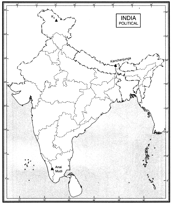
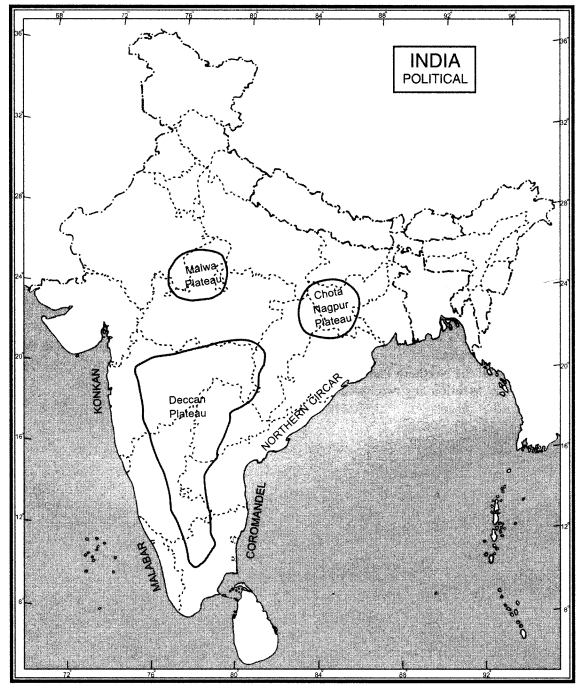
Question 94.
Locate and label the following on the map of India.
(a) Mountain Ranges: The Karakoram, the Zaskar, the Shiwalik, the Aravali, the Vindhya, the Satpura, the Western and Eastern Ghats.
(b) Mountain Peaks: K2, Kanchenjunga, Anai Mudi
(c) Plateau: Deccan Plateau, Chota Nagpur Plateau, Malwa Plateau.
(d) Coastal Plains: Konkan, Malabar, Coromandel and Northern Circar.
Answer:
(a) Mountain Ranges: The Karokoram, the Zaskar, the Shiwaliks, the Aravali, the Vindhya, the Satpura, the Western and Eastern Ghats.
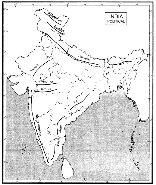
(b) Mountain Peaks: K2, Kanchenjunga, Anai Mudi
(c) Plateau: Deccan plateau, Chotta Nagpur Plateau, Malwa Plateau
(d) Coastal plains: Konkan, Malabar, Coromandel and Northern Circar
We hope the given CBSE Class 9 Geography Chapter 2 Extra Questions Physical Features of India Pdf free download will help you. If you have any query regarding NCERT Extra Questions for Class 9 Social Science SST Geography Chapter 2 Physical Features of India, drop a comment below and we will get back to you at the earliest.