Class 9 History Chapter 2 Extra Questions and Answers Socialism in Europe and the Russian Revolution

CBSE Class 9 History Chapter 2 Extra Questions Socialism in Europe and the Russian Revolution Pdf free download are part of Extra Questions for Class 9 Social Science. Here we have given NCERT Extra Questions for Class 9 Social Science SST History Chapter 2 Socialism in Europe and the Russian Revolution.

You can also practice NCERT Solutions for Class 9 History Chapter 2 Questions and Answers on LearnInsta.com.

NCERT Class 9 History Chapter 2 Extra Questions and Answers Socialism in Europe and the Russian Revolution

Very Short Answer Type Questions

Question 1.
Who controlled economic and social powers before the 18th century in France?
Answer:
The aristocracy and the church controlled the economic and social powers in France before the 18th century.

Question 2.
Name any two Indians who talked of the significance of the French Revolution.
Answer:
Raja Rammohan Roy and Derozio talked of the significance of the French Revolution.

Question 3.
What were the varied responses in Europe about transformation of society?
Answer:
There were some who accepted that some changes were necessary but wished to have a gradual shift while others wanted radical restructuring of the society.

Question 4.
Mention the type of government favoured by the liberals.
Answer:
They insisted on a representative, elected parliamentary government, subject to laws interpreted by a well-trained judiciary that was independent of rulers and officials,

Question 5.
How can you say that the ‘liberals’ were not ‘democrats’? [HOTS]
Answer:
The liberals were not democrats because they did not believe in universal adult franchise and felt that only men of property should have a right to vote. They were against voting rights to women.

Question 6.
Mention one significant view of the radicals.
Answer:
Radicals wanted a nation in which the government was based on the majority of a country’s population.

Question 7.
When did the conservatives become receptive to the need of change?
Answer:
After the French Revolution, the conservatives became receptive to some kind of change.

Question 8.
Which group of ideology was against any kind of political or social change earlier in the 18th century?
Answer:
The conservatives, in the early 18th century were against any kind of political and social change.

Question 9.
What were the ideas of ‘conservatives’ regarding social change in the 19th century?
Answer:
The conservatives believed that some change was required in the society but the changes should be slow.

Question 10.
What kind of developments took place as a result of new political trends in Europe?
Answer:
As a result of new political trends in Europe industrial revolution occurred, new cities came up and railways expanded.

Question 11.
List the major change during industrialisation.
Answer:
Men, women and children were brought to factories during industrialisation.

Question 12.
What were the firm beliefs of the liberals?
Answer:
The liberals firmly believed in the value of individual effort, labour and enterprise.

Question 13.
How would society develop according to the liberals?
Answer:
Liberals believed that societies would develop if freedom of individuals was ensured, if poor could labour, and those with capital could operate without restraint.

Question 14.
Who were the people that wanted to put an immediate end to the existing governments in Europe in 1815?
Answer:
Some nationalists, liberals and radicals who became revolutionaries wanted to put an immediate end to the existing governments in Europe in 1815.

Question 15.
What were nationalists views about revolutions?
Answer:
The nationalists viewed that revolutions would create nations where all citizens would enjoy equal rights.

Question 16.
Who was responsible for achieving equal rights in Italy?
Answer:
An Italian nationalist, Giuseppe Mazzini, conspired with others to achieve equal rights to all citizens in Italy after 1815.

Question 17.
Why were the socialists against private property?
Answer:
The socialists were against private property because individuals who owned property were concerned only about their personal gains rather than social welfare.

Question 18.
What were the two different visions of the socialists for future?
Answer:
Some socialists like Robert Owen believed in the idea of cooperatives and build cooperative community called New Harmony in Indiana. Others like Louis Blanc felt that it could not be achieved through individual initiative. Governments should encourage cooperatives.

Question 19.
What did Karl Marx want workers to overthrow? Why?
Answer:
Karl Marx wanted the workers to overthrow capitalism and free themselves from capitalist exploitation.

Question 20.
Which international body was formed in Europe in the 19th century to coordinate the efforts of socialists all over Europe?
Answer:
An international body was formed in Paris in 1889, to coordinate the efforts of socialists all over Europe. It was called the Second International.

Question 21.
Name the socialist parties formed in Britain and France in 1905.
Answer:
Labour Party was formed in Britain by socialists and trade unionists. A Socialist Party was also formed in France.

Question 22.
Who was the ruler of Russia and its empire in 1914?
Answer:
The ruler of Russia and its empire was Tsar Nicholas II.

Question 23.
Mention the regions included in Russian empire.
Answer:
The Russian empire included territory around Moscow and current-day Finland, Latvia, Lithuania, Estonia, parts of Poland, Ukraine and Belarus. It also comprised some of today’s Central Asian states.

Question 24.
Name the religions practised in the Russian empire.
Answer:
The religions in the Russian empire included Russian Orthodox Christianity’, Catholics, Protestants, Muslims and Buddhists.

Question 25.
Which was the major occupation of Russian people at the beginning of twentieth century?
Answer:
Agriculture was the occupation of about 85 per cent of the Russians at this time.

Question 26.
Name the prominent industrial areas in the Russian empire.
Answer:
St Petersburg and Moscow were the prominent industrial areas.

Question 27.
Name any two factors that led to the setting up of industries in Russia by the end of the 19th century.
Answer:
The expansion of Russian railway network and increase in foreign investment led to the setting up of industries in Russia by the end of the 19th century.

Question 28.
What was the commune/mir?
Answer:
The commune/mir was a cooperative community of people in Russia living together and sharing possessions and responsibilities.

Question 29.
Mention the role of Socialist Revolutionary Party. .
Answer:
The Socialist Revolutionary Party struggled for peasants’ rights and demanded that land belonging to nobles be transferred to peasants.

Question 30.
On what point did the Social Democrats and Socialist Revolutionaries differ with each other? [HOTS]
Answer:
The socialists felt that peasants were not a united group. Some were poor while others were rich, some worked as labourers while others were capitalists.

Question 31.
How was the Socialist Revolutionary Party divided over the strategy of organisation?
Answer:
One group under Lenin felt that the party should be disciplined and number and quality of members should be maintained. Others wanted the party to be open to all.

Question 32.
Which communities demanded constitution during 1905 Revolution? Who supported them?
Answer:
Liberals, Social Democrats and Socialist Revolutionaries with peasants and workers demanded constitution. Nationalists and jadidists supported them.

Question 33.
Who were jadidists?
Answer:
The jadidists were the Muslim reformers within the Russian empire. They wanted modernised Islam to lead their societies.

Question 34.
What was Bloody Sunday?
Answer:
Bloody Sunday was an incident when a workers procession led by Father Gapon was attacked by the police and at Winter Palace Cossacks killing hundreds.

Question 35.
What do you mean by Union of Unions?
Answer:
During the 1905 revolution, lawyers, doctors, engineers and other middle class workers established a union of unions and demanded a constituent assembly.

Question 36.
Why did the Tsar dismiss the first Duma within 75 days of its election?
Answer:
The Tsar dismissed the first Duma within 75 days of its election because the Tsar did not want any reduction in his power and anyone to question his authority.

Question 37.
Between which two European alliances First World War broke out?
Answer:
The two European alliances were Germany, Austria and Turkey and France, Britain and Russia.

Question 38.
Give one instance of high anti-German sentiments in Russia.
Answer:
Renaming of St Petersburg a German name, as Petrograd showed the high anti-German sentiments.

Question 39.
What made autocracy unpopular in Russia?
Answer:
The German origin of the Tsarina Alexandra and advisers like the monk Rasputin made the autocracy unpopular in Russia.

Question 40.
What were the divisions in the layout of the Petrograd city?
Answer:
Workers’ quarter and factories were located on the right bank of River Neva whereas on the left bank fashionable area, the Winter Palace and official building were located.

Question 41.
Which division faced the food shortages in February 1917?
Answer:
The workers’ quarters was affected deeply with the food shortages in February.

Question 42.
To which the Tsar’s desire of Parliamentarians were opposed? Why?
Answer:
Parliamentarians were opposed to Tsar’s desire to dissolve the Duma to preserve the elected government.

Question 43.
Why did a lockout take place at a factory on the right bank of the River Neva on 22 February, 1917?
Answer:
A lockout took place at a factory on the right bank of the River Neva on 22nd February, 1917 in favour of the workers at the left bank of the river. They had a bad time due to severe winter and food shortages.

Question 44.
Which events took place after the Tsar abdicated on 2nd March?
Answer:
The events that took place after the abdication of Tsar on 2nd March 1917 were:
(a) Forming of the Provisional Government.
(b) Decision to set up a constituent assembly.

Question 45.
Who formed the Provisional Government to run the country?
Answer:
Soviet and the Duma leaders formed a Provincial Government to run the country.

Question 46.
Who were influential in the Provisional Government?
Answer:
Army officials, landowners and industrialists were influential in the Provisional Government.

Question 47.
What were Lenin’s ‘April Theses’?
Answer:
The three demands of Vladimir Lenin after his return to Russia in April 1917 were called Lenin’s April Theses’.

Question 48.
Why were most of the Bolshevik Party members initially surprised by ‘April Theses’?
Answer:
Most of the Bolshevik Party members were surprised by the April Thesis’ because of the following reasons.
(a) They wanted continuation of World War I.
(b) They thought that time was not ripe for a socialist revolution.
(c) Government needed to be supported at this time.

Question 49.
What do you mean by nationalisation of banks and industries?
Answer:
This meant that the ownership and management of banks and industries held by the government.

Question 50.
Name the ship that protected the Winter Palace during the October Revolution in 1917 in Russia.
Answer:
Aurora protected the Winter Palace during the October Revolution in 1917 in Russia.

Question 51.
What was Budeonovka?
Answer:
Budeonovka was the Soviet hat that was chosen to assert change in army uniform.

Question 52.
What was the Bolshevik Party renamed after October Revolution?
Answer:
Bolshevik Party was renamed the Russian Communist Party after the October Revolution.

Question 53.
What was Cheka?
Answer:
Cheka was the secret police set up by the Bolsheviks to clamp down on its critics.

Question 54.
To whom did the ‘reds’, ‘greens’ and ‘whites’ refer to during the Civil War in Russia?
Answer:
The ‘reds’ were the Bolsheviks
The ‘greens’ were the Socialist Revolutionaries
The ‘whites’ were the pro-Tsarists.

Question 55.
Name the countries that supported the Socialist Revolutionaries and the pro-Tsarists in Russia.
Answer:
France, America, Britain and Japan supported the Socialist Revolutionaries and pro-Tsarists in Russia.

Question 56.
What were Stalin’s views about rich peasants and traders?
Answer:
Stalin viewed that rich peasants and traders held stocks of foodgrains hoping for higher prices in future.

Question 57.
Who were the ‘Kulaks’?
Answer:
Kulakas were the rich peasants who held most of the land in Russia.

Question 58.
What was the problem associated with small-sized farms in Russia? .
Answer:
Production in the small-sized farms declined as modern farming cannot be used.

Short Answer Type Questions

Question 59.
Liberals were not Democrats. Explain. [CBSE 2016]
Or
Why do we say that liberals could not be called ‘democrats’?
Answer:
The liberals could not be called democrats because even though they argued for a representative, elected parliamentary government, subject to laws interpreted by a well-trained judiciary that was independent of rulers and officials, they did not believe in universal adult franchise and also did not want the voting rights for women. They felt right to vote should only be given to the propertied men.

Question 60.
Describe the views of radicals. [CBSE 2014]
Answer:
The following were the viewpoints of the radicals.
(a) Radicals wanted a nation in which government was based on the majority of a country’s population.
(b) Many supported women’s suffragette movements.
(c) They opposed the privileges of great landowners and wealthy factory owners. Though they favoured private property, they disliked concentration of property in the hands of a few.

Question 61.
What were the viewpoints of the conservatives?
Answer:
The conservatives had the following viewpoints.
(a) In the beginning of the eighteenth century, they were opposed to the idea of change.
(b) Later in the nineteenth century, they accepted that some change was inevitable.
(c) At the same time they believed that the past had to be respected and change had to be brought about through a slow process.

Question 62.
How should society, according to liberals and radicals, develop?
Answer:
Liberals and radicals were often property owners and employers. They acquired wealth through industrial ventures and trade. They believed that society could develop in the following ways.
(a) They strongly believed that if the workforce is healthy and educated, more profits could be earned.
(b) They firmly believed in valuing individual efforts, labour and enterprise.
(c) They believed that the society would develop if poor could work and freedom of all individuals is ensured.
(d) For this, they wanted investment and trade to be carried out without restrictions.

Question 63.
Why were socialists against private property and saw it as the root of all social ills? [HOTS]
Or
To what changes did the socialists campaign for?
Or
Explain the Socialist view on private property.
Answer:
The socialists were against private property because of the following reasons.
(a) They believed that private property was the root cause of all social evils.
(b) Individuals who owned property, did provide employment but at the same they are much more concerned with personal gains.
(c) They did not bother about the welfare of the people. .
(d) Socialists also felt that if society controlled property, more attention would be paid to collective social interests and concentration of wealth in the hands of a few could be restricted.

Question 64.
What was the basic principle of the Marxist theory?
Answer:
Marx believed that the condition of workers could not improve as long as private capitalists had profit motive. Workers had to overthrow capitalism and the rule of private property. Workers must construct a radically socialist society where all property was socially controlled. This would be a communist society, the natural society of the future.

Question 65.
Explain how workers were divided in social groups. [CBSE 2013]
Answer:
The workers were divided in social groups in Russia in the following ways.
(a) Some workers were closely linked to their villages while others settled in the cities permanently,
(b) The division among the workers was on the basis of skills they possessed. Metalworkers were on the high level as their work required training.
(c) Apart from males, women also formed a considerable working force in the factories though they were paid less than the males.

Question 66.
Discuss the relationship between peasants and nobles in Russia during early 19th century.
Answer:
Peasants cultivated most of the land that was owned by the nobility, the crown and the Orthodox Church. Nobility had no respect except in few cases. Peasants demanded the land of the nobles to be distributed to them. Often they refused to pay rent and even murdered landlords. Such events were on rise all over Russia.

Question 67.
How did Social Democrats disagree with Socialist Revolutionaries? ICBSE 2016]
Answer:
Social Democrats disagreed with Socialist Revolutionaries in the following ways.
(a) Social Democrats believed workers to be the mainforce of revolution whereas Socialist Revolutionaries argued that peasants would be the revolutionary class.
(b) Social Democrats wanted benefits for the workers and control on the factors of production. Socialist Revolutionaries on the other hand demanded land to the peasants.
(c) Social Democrats felt that peasants were not a united group as they were rich and poor and many owned large tracts of land. Socialist Revolutionaries favoured peasants as natural socialists.

Question 68.
What was the difference between Bolshevik and Menshevik group. [CBSE 2016]
Or
Who were the Bolsheviks and Mensheviks?
Answer:
The Bolsheviks were the majority group led by Vladimir Lenin who thought that in a repressive society like Tsarist Russia, the party should be disciplined and control the number and quality of its members. They were the group who conducted the Russian Revolution.
Mensheviks, on the other hand, were the minority group who thought that the party should be open to all. They did not believe in revolution but wanted to bring changes through democratic means.

Question 69.
What made the Tsar the ‘autocrat of all the Russians’? Describe the steps he took just before the Russian Revolution.
Answer:
Russia followed autocracy. The Tsar was not subject to Parliament. This made the Tsar the autocrat of all Russia. The liberals in Russia campaigned to end this state of affairs.
The following steps were taken by the Tsar just before the Russian Revolution to ascertain his authority.
(a) All political parties were declared illegal in Russia.
(b) Every possible effort was taken to crush the rebellion and revolution against the Tsar.

Question 70.
Why is Tsarist Russia termed as a repressive society?
Answer:
Tsarist Russia is termed as a repressive society because of the following reasons.
(a) Large tracts of land were owned by nobility, crown and the Orthodox Church. Nobles enjoyed privileges at the cost of the common people.
(b) Political parties were illegal. No one could raise voice against the aristocratic class.
(c) Tsar enjoyed unconditional power without being responsible to any one.

Question 71.
Describe the incident known as ‘Bloody Sunday’.
Answer:
The following events gave way to the incident known as Bloody Sunday.
(a) The dismissal of four members of the Assembly of Russian Workers called for an industrial action by the workers.
(b) Over 110,000 workers in St Petersburg went on strike in 1905, demanding a reduction in the working day to eight hours, an increase in wages and improvement in working conditions.
(c) When this procession led by father Gapon reached the Winter Palace it was attacked by the police and the Cossacks. Hundreds of the workers were killed and many hundreds wounded. This incident came to be known as Bloody Sunday. It started a series of events that later resulted in the 1905 Revolution.

Question 72.
How did the destruction of Russian industries after the First World War become one of the causes of resentment of people?
Or
What effects did the First World War have on industry of Russia?
Answer:
The First World War had a devastating impact on industries. Russia had few industries and on that supplies of industrial goods were cut off due to war. Industrial equipments began to disintegrate rapidly, railway lines began to break down. All the able-bodied men were engaged in war which resulted in the shutdown of the small workshops. Grains were supplied to the army engaged in war. This created food shortages. In cities, bread and flour became scarce. Riots at the bread shops became a common scene in Russia.

Question 73.
Discuss Lenin’s ‘April Theses’. [CBSE 2016]
Or
What were the demands referred in Lenin’s ‘April Theses’?
Answer:
The following were the demands referred to in Lenin’s April Theses’.
(a) World War I should be brought to an end.
(b) Land should be transferred to the peasants.
(c) Banks should be nationalised.

Question 74.
What were the effects of the February Revolution in Russia?
Answer:
Ans. The following were the effects of the February Revolution in Russia.
(a) The Tsar abdicated and monarchy was brought down.
(b) The Soviet leaders and Duma leaders formed a Provisional Government to run the country.
(c) Russia’s future would be decided by a constituent assembly, elected on the basis of universal adult suffrage.

Question 75.
Why did the Kerenskii government become unpopular in Russia? [HOTS]
Answer:
The Kerenskii government became unpopular in Russia because of the following reasons.
(a) He tried to suppress the workers’ movement. Peasants in the countryside had started demanding redistribution of land.
(b) The Bolshevik demonstrators was suppressed. Many of them had to go into hiding.
(c) Kerenskii was suspected of setting up a dictatorship and Lenin persuaded the Petrograd Soviet and Bolshevik Party to agree to a socialist seizure of power.
(d) Sensing the trouble to be caused by the revolutionaries he left the city to summon troops.

Question 76.
Mention any two changes introduced by Stalin in the Russian economy. How did Stalin deal with the critics?
Answer:
The following changes were introduced by Stalin.
(a) Elimination of kulaks, the well-to-do farmers. The land from the kulaks was taken and state-controlled farms were established.
(b) Collectivisation of land i.e., Stalin’s collectivisation programme was followed. All peasants had to cultivate collective farms (Kolkohz) and the profit was shared by the peasants working on the land.
There were peasants’ resistances which Stalin dealt with severely. The critics were charged with conspiracy against socialism. Many were deported and exiled and forced into prisons or labour camps. Many were forced to make false statements under torture and were later executed.

Question 77.
Why was the decision to collectivise farms taken?
Answer:
Russia was facing acute shortages of grain supplies. The price at which grains must be sold was fixed by the government. Still the peasants refused to sell their grains to the government. Stalin thought that rich peasants and traders in the countryside were holding stocks in the hope of higher prices. This created a shortage. Therefore, the decision to collectivise farms was taken. It was felt that small size farms were not as productive as they could not be modernised which caused the shortage. Modern farming was the need of the hour. They wanted to run farms along industrial lines with machinery.

Question 78.
“By the 1950s it was acknowledged within the country that the style of government in the USSR was not in keeping with the ideals of the Russian Revolution.” Why was this said?
Answer:
By 1950s the style of government in the USSR was not in keeping with the ideals of the Russian Revolution. It was said because of the following reasons:
(a) No doubt Russia, being a backward country, had become a great power with developments in industries and agriculture and feeding the poor. But at the same time its citizens were denied the essential freedoms.
(b) Its developmental projects were carried through repressive policies.
(c) Workers faced hardships with poor working conditions.

Question 79.
What were the main objectives of the Russian Revolutionaries? [HOTS]
Answer:
The following were the main objectives of the Russian Revolutionaries.
(a) Peace: The Russian revolutionaries wanted to maintain peace and order in the country. The people of Russia were against the war. Just after the fall of Tzar, Russia withdrew from the war.
(b) Land to the Tiller: The Russian revolutionaries were of the opinion that the agricultural land should be allotted to the cultivators as the peasants in Russia were leading a miserable life under the large landowners.
(c) Control of industry by the workers: In Russia, the capitalists greatly exploited the workers. This made the condition of Russian workers deplorable. There was great need to control the industry by workers themselves.
(d) Equal status for the non-Russian nationalists: The Russian revolutionaries demanded equal status
for the non-Russian nationalities. Just after the revolution, a declaration of the people was issued by the new government conferring them political autonomy. (any three)

Long Answer Type Questions

Question 80.
What changes did industrialisation bring to the then society in Russia?
Answer:
The following changes were brought in the Russian society with the advent of industrialisation.
(a) The society saw profound social and economic changes.
(b) It was a time when new cities came up and new industrialised regions developed and railways expanded.
(c) Industrial Revolution brought men, women and children to factories.
(d) Work hours were often long and wages were very low.
(e) During the time of low demand, unemployment was common.
(f) As the towns were growing rapidly, problems like housing and sanitation emerged.

Question 81.
What solutions did radicals and liberals find to the problem of the industrial society?
Answer:
The following solutions were found by the radicals and the liberals to the problems of Industrial society.
(a) They felt that efforts should be made to make the workforce healthy and educated.
(b) They were opposed to the privileges enjoyed by the old aristocracy.
(c) They advocated value of individual effort, labour and enterprise.
(d) They thought of freedom of individuals so that poor could labour and those with capital could operate freely. This would develop the society.
(e) It was also sought that the government should be removed through revolution.

Question 82.
Explain how a society, according to socialists, can operate without property. What would be the basis of socialist society?
Answer:
Socialists had different visions of the future. Robert Owen, a leading English manufacturer, sought to build a cooperative community called New Harmony in Indiana (USA). Some other socialists felt that cooperatives could not be built on a wide scale through individual initiative only. The governments must encourage cooperatives and replace capitalist enterprise. The same view was propagated by Louis Blanc in France. It was said that cooperatives were to be associations of people who produced goods together and divided the profits according to the work done by members.
More ideas were added to this body of arguments by Karl Marx and Friedrich Engels. Marx argued that industrial society was capitalist who owned resources and invested in the factories. The profit was produced by the workers but they did not gain anything. Their condition could improve only if they were freed from the clutches of capitalist exploitation.
Control of means and factors of production by the workers themselves can be the basis of such a socialist society. For this, the workers needed to construct a radically socialist society where all property was socially controlled. This would be a communist society.

Question 83.
What developments took place in Europe in support of socialism?
Answer:
The following developments took place in Europe in support of socialism.
(a) An international body, called the Second International was formed by the socialists to coordinate the efforts of the workers.
(b) Workers Associations were formed to fight for better living and working conditions.
(c) Funds were set up to help members in times of distress.
(d) Workers demanded a reduction in working hours and the right to vote.
(e) In many places in Europe, these associations worked closely with the Social Democratic Party and helped it win parliamentary seats.
(f) In 1905, socialists and trade unionists formed Labour Party in Britain and a Socialist Party in France.

Question 84.
What were the events preceding the 1905 Revolution in Russia?
Answer:
The following events preceded the 1905 Revolution in Russia.
(a) The year 1904 was a particularly bad one for Russian workers. Prices of essential goods rose rapidly and the real wages declined.
(b) The membership of workers’ associations rose dramatically.
(c) There was a call for an industrial action when four of the workers at the Putilov Iron Works were dismissed.
(d) There were mass strikes by the workers demanding reduction in the working hours, an increase in wages and improvement in working conditions.
(e) When a procession of workers led by the Father Gapon reached the Winter Palace it was attacked by the police and the cossacks that killed hundreds of the workers. This incident is known as Bloody Sunday.
(f) There were strikes all over the country and universities closed, student bodies staged walkouts, complaining lack of civil liberties. Various unions of doctors, engineers and other middle-class workers were established that demanded a constituent assembly. (any five)

Question 85.
Describe the steps taken by Tsar Nicholas II after the Revolution to maintain his authority.
Answer:
The following steps were taken by Tsar Nicoholas II after the Russian Revolution to maintain his authority:
(a) Under pressure, he allowed the creation of an elected consultative Parliament or Duma.
(b) Most committees and unions were declared illegal. Severe restrictions were placed on political activity.
(c) Later he dismissed the first Duma within 75 days and re-elected second Duma within three months.
(d) The voting laws were changed.
(e) The third Duma was packed with conservatives and tried to keep liberals and revolutionaries out of the Duma.

Question 86.
What were the conditions in Russia during the First World War?
Answer:
The following were the conditions in Russia during the First World War.
(a) Russia became a part of First World War in 1914. In the beginning, the war was popular. The Tsar refused to consult the main parties in the Duma. This led to weaken the support within Russia. Anti-German sentiments among the Russians were on an increase. St Petersburg, a German name was renamed as Petrograd.
(b) Russia’s armies suffered defeats in Germany and Austria between 1914 and 1916. Casualties were very high. Soldiers did not wish to fight such a war. The retreating Russian army destroyed crops and buildings to prevent them from being used by the enemies. This led to millions of refugees in Russia.
(c) The Tsar and the government were further discredited for the situation.
(d) The war also had a severe impact on industry. Russia had few industries and that too were cut
off from suppliers of industrial goods by German control of the Baltic Sea. Industrial equipment began to disintegrate, railway lines began to break down.
(e) Able-bodied men were called up to the war that resulted in labour shortages and shut down of small workshops.
(f) Grains were sent to feed the army which led to food shortage in cities. Riots at bread shops were common. (any five)

Question 87.
Discuss the role and importance of Lenin in the history of the USSR. [HOTS]
Or
Examine the role of Lenin in Russian Revolution.
Answer:
After returning from exile, Lenin felt that the time was right for the Soviets to take over the power in Russia. Following was the role played by Lenin in Russian Revolution 1917.
(a) He led the Bolsheviks in the revolution.
(b) He declared three points, to end war, transfer land to peasants and nationalisation of banks that came to be known as April Theses.
(c) He introduced radical land reforms that led to turn Russia into a socialist society.
(d) He was the driving force behind the October Revolution that eventually led to the formation of the Soviet Union.
(e) Lenin was instrumental in the victory of Bolsheviks in the civil war (1917-1922).

Question 88.
Why did Bolshevik Party accept the ‘April Theses’? Give any five reasons. [CBSE 2016]
Answer:
Bolshevik Party accepted the April Theses’ because of the following reasons.
(a) The Provisional Government under Kerenskii failed to fulfil the aspirations of the people like land to the tiller, peace, control of industries by the workers, etc. Rather it became more unpopular.
(b) The government was under the influence of landowners, army officials and industrialists that affected its decisions.
(c) Lenin felt that time had come to seize the power from the government.
(d) People’s demands were included in the programme along with exit from the war and nationalisation of banks.
(e) Lenin’s view was accepted when the Provisional Government began suppressing the Bolsheviks.

Question 89.
Discuss the civil war that took place in Russia after the October Revolution and its consequences.
Answer:
When the Bolsheviks ordered land redistribution the Russian army began to break up. They wished
to return home for getting land. Non-Bolshevik socialists, liberals and supporters of autocracy condemned the Bolshevik uprising with the support of those who were apprehensive of the growth of socialism. There was mass looting, banditry and famine during the civil war. The pro-Tsarists who supported private property suppressed the peasants and took their land. This made non-Bolsheviks unpopular. Bolsheviks were supported by non-Russian nationalities and jadidists. Local nationalists were massacred by the Bolsheviks.
Consequences:
The following were the consequences of the civil war in Russia.
(a) The civil war created confusion about the Bolsheviks way of working.
(b) It made the Bolsheviks quite unpopular.
(c) Non-Russian nationalities were given political autonomy.
(d) Nomadism was harshly discouraged.
(e) The Bolsheviks failed to win over different nationalities.

Question 90.
Mention the important steps taken by Lenin to improve the agriculture and economy of Russia.
Answer:
The following steps were taken by Lenin to improve agriculture and economy of Russia.
(a) Most of the industries and banks were nationalised.
(b) He ordered land redistribution and permitted peasants to cultivate the land.
(c) Centralised planning was introduced. Five year plans were made.
(d) The government fixed all price during the first two year plans.
(e) Communes were set up and income was divided according to the principles of cooperative commission.

Question 91.
What steps were taken to improve the condition of factory workers and peasants in Russia after the civil war?
Answer:
The following steps were taken to improve the conditions of the factory workers in Russia after the civil war.
(a) Various industries were set up like in Magnitogorsk city.
(b) Extended schooling system developed so that factory workers could also access universities.
(c) Creches for children of women factoryworkers were established.
(d) Cheap public healthcare was provided. Model living quarters were built up for workers.
(e) Lenin ordered land redistribution and permitted peasants to cultivate the land.
(f) Communes were set up and income was divided according to the problems of cooperative commission.

Question 92.
Critically examine Stalin’s collectivisation programme. [HOTS]
Answer:
Stalin began collectivisation programme to find a solution to the food shortage. But this proved to be disastrous in the subsequent years in the following ways:
(a) The policy of eliminating kulaks and establishing state-owned farms was widely criticised.
(b) Peasants were compelled to work in the kolkhoz.
(c) Peasants resisted the authorities and their livestock were destroyed. It resulted in the decline of cattle.
(d) Policy of deportation and severe punishment was followed for all those who refused to do so.
(e) There was no such increase in the production of food grains. Even his party members criticised Stalin the way the policy was followed.

Question 93.
Explain the global influence of the Russian Revolution and the USSR.
Or
Explain the impact of the Russian Revolution on the world. [CBSE 2014]
Answer:
The following was the global influence of Russian Revolution and the USSR.
(a) In many countries, communist parties were formed on the line of Russia.
(b) It gave the world a new economic system known as socialism.
(c) The Bolsheviks encouraged colonial peoples to follow their experiment. It inspired a number of freedom movements in other countries.
(d) Many non-Russians from outside the USSR participated in the Conference of the Peoples of the East and the Bolshevik-founded Comintern. Some even received education in the USSR’s Communist University of the Workers of the East.
(e) By the time the Second World War broke, socialism had acquired a global face.
(f) Though by the end of the twentieth century, the image of USSR as a socialist country declined, yet it’s socialist ideals were respected and rethought in many ways suiting individual interests.

Map Skills

Question 94.
Seven features A, B, C, D, E, F and G are marked on the political map of world. Identify these features with the help of given information and write their correct names.

  • Central Powers of First World War.
  • Allied Powers of First World War.

Answer:
Class 9 History Chapter 2 Extra Questions and Answers Socialism in Europe and the Russian Revolution img-1

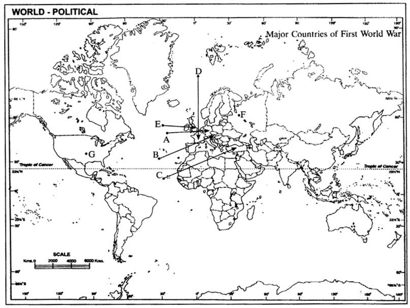
  • Central Powers → A. Germany, B. Austria-Hungary, C. Turkey (Ottoman Empire)
  • Allied Powers → D. France, E. England, F. Russia, G. Ameriea (USA)

We hope the given CBSE Class 9 History Chapter 2 Extra Questions Socialism in Europe and the Russian Revolution Pdf free download will help you. If you have any query regarding NCERT Extra Questions for Class 9 Social Science SST History Chapter 2 Socialism in Europe and the Russian Revolution, drop a comment below and we will get back to you at the earliest.

Class 9 Geography Chapter 4 Extra Questions and Answers Climate

CBSE Class 9 Geography Chapter 4 Extra Questions Climate Pdf free download are part of Extra Questions for Class 9 Social Science. Here we have given NCERT Extra Questions for Class 9 Social Science SST Geography Chapter 4 Climate.

You can also practice NCERT Solutions for Class 9 Geography Chapter 4 Questions and Answers on LearnInsta.com.

NCERT Class 9 Geography Chapter 4 Extra Questions and Answers Climate

Very Short Answer Type Questions

Question 1.
What is climate? [CBSE 2014]
Answer:
Climate refers to sum total of weather conditions over a large area for a long period of time (30 – 40 years).

Question 2.
Distinguish between climate and weather. [CBSE 2016]
Answer:
Climate refers to the sum total of weather conditions and variations over a large area for a long period of time (thirty years).
Weather refers to the state of the atmosphere over an area at any point of time.

Question 3.
Name the elements of climate and weather.
Answer:
Elements of weather and climate are temperature, atmospheric pressure, wind, humidity and precipitation.

Question 4.
What is the climate of India?
Answer:
India’s climate is described as “Tropical Monsoon Type of Climate”.

Question 5.
What does the word ‘Monsoon’ mean?
Answer:
The word Monsoon is derived from the Arabic word ‘mausim’ which literally means season. It refers to the seasonal reversal in the wind direction during a year.

Question 6.
What is the variation of temperature in summer in India?
Answer:
In summer, the mercury occasionally touches 50°C in some parts of Rajasthan desert, whereas it may be around 20°C in Pahalgam in Jammu and Kashmir.

Question 7.
What is the variation of temperature in winter in India?
Answer:
In winter, the temperature in Drass in Jammu and Kashmir is as low as – 45°C and Thiruvananthapuram may have 22°C.

Question 8.
What is the variation of annual precipitation in India?
Answer:
The annual precipitation is over 400 cms in Meghalaya and less than 10 cms in Ladakh and western Rajasthan.

Question 9.
In which months is the season of rainfall experienced in India?
Answer:
Most parts of India receive rainfall from June to September.

Question 10.
Why do the coastal areas of India experience less contrast in temperature?
Answer:
The coastal areas experience less contrast in temperature because of the influence of the sea, e.g. Mumbai experiences an equable climate.

Question 11.
Why is there decrease in rainfall from east to west in the Northern Plains?
Answer:
There is general decrease in the amount of rainfall from east to west in the Northern Plains as the winds have less moisture in them when they reach the western side.

Question 12.
What does the term continentality mean?
Answer:
As the distance from the sea increases the moderating influence of the sea decreases and the people experience extreme weather conditions. This is called continentality i.e. very hot in summers and cold in winters, e.g. in Delhi.

Question 13.
Why does the amount of solar radiation vary with latitude?
Answer:
The amount of solar radiation varies with latitude because of the curvature of the earth. The temperature decreases from the equator to the poles.

Question 14.
How does the temperature decrease with altitude?
Answer:
The temperature of air decreases at the rate of 1°C for every 165 m of ascent. This is because the air density decreases with height. That is why hills are cooler in summers.

Question 15.
Which two factors affect the wind and pressure system of an area and how?
Answer:
The latitude and the altitude of the place affect the temperature and rainfall of the area.

Question 16.
What are ocean currents? Name the two types.
Answer:
Ocean currents are streams of water that move in the same direction throughout the year. The two types of ocean currents are warm currents and cold currents.

Question 17.
How does the relief of an area affect the climate of a place?
Answer:
The relief of a place affects the climate of a place when the high mountains act as barriers for cold and hot winds, e.g. the Himalayas. They also affect the amount of rainfall if they are very high. They force the wind to give heavy rain on the windward side and less rain on the leeward side.

Question 18.
Which parallel of latitude passes through the centre of India?
Answer:
The parallel of latitude is the Tropic of Cancer, 231/2°N.

Question 19.
What is the influence of the division of India by the Tropic of Cancer?
Answer:
The Tropic of Cancer divides India into the Tropical zone which lies to the south and the sub-tropical area which lies to the north. It gives India’s climate a tropical and a sub-tropical character.

Question 20.
What is Coriolis force?
Answer:
It is an apparent force caused by the earth’s rotation. The Coriolis force is responsible for deflecting the winds to the right in the northern hemisphere and towards the left in the southern hemisphere, due to the rotation of the earth.

Question 21.
What do you know about South-Western Monsoon Winds?
Answer:
Air moves from the high pressure area over the southern Indian Ocean in a south easterly direction, crosses the equator and gets deflected towards the rights towards the low pressure area over the Indian subcontinent. This is known as south western monsoon.

Question 22.
What are jet streams?
Answer:
Jet streams are fast flowing winds at high altitude of above 12,000 metres in the troposphere.

Question 23.
What are sub-topical westerly jet streams?
Answer:
The sub-tropical westerly jet streams are located approximately over 27° – 30° north latitude.

Question 24.
In which parts of India the sub-tropical westerly jet streams blow?
Answer:
The sub-tropical westerly jet streams flow south of the Himalayas all through the year except in summers. They are responsible for the western cyclonic disturbances in north and north western parts.

Question 25.
What are tropical easterly jet streams?
Answer:
An easterly jet stream known as the tropical easterly jet stream blows over peninsular India approximately at 14°N during the summer months.

Question 26.
What are western cyclonic disturbances?
Answer:
These are shallow cyclonic depressions which originate over the east Mediterranean sea, travel eastwards and influence the weather conditions of north western parts of India during winters.

Question 27.
Which warm ocean current replaces the Peruvian cold current?
Answer:
El Nino.

Question 28.
On what basis is the year divided into seasons?
Answer:
On the basis of the generalised monthly atmospheric conditions.

Question 29.
What does the word ‘Monsoon’ refer to?
Answer:
The word ‘Monsoon’ refers to the seasonal reversal in the wind direction during a yean

Question 30.
Where is the monsoonal type of climate found in Asia?
Answer:
In south and southeast Asia.

Question 31.
Name the two elements which are responsible for the regional variations within the country.
Answer:
The two important elements are temperature and precipitation.

Question 32.
What is the temperature in Rajasthan in summer?
Answer:
50°C

Question 33.
Where is Drass located? What are the winter temperatures?
Answer:
Drass is located in Jammu and Kashmir. The winter temperatures are as low as minus 45°C.

Question 34.
Why do the houses in Rajasthan have thick walls and flat roofs?
Answer:
The houses in Rajasthan have thick walls to prevent them from becoming hot. The thick walls keep the interior cool. The flat roofs are used to collect water when it rains and in summer they are used for drying dates and storage purposes.

Question 35.
Why are houses in Assam built on stilts?
Answer:
Assam receives very heavy rain and often water accumulates on the ground. There is a thick undergrowth which makes it difficult for the people to live. So houses are built above the ground level on stilts.

Question 36.
Why do houses in the Terai region, Goa and Mangalore have sloping roofs?
Answer:
All the three regions, the Terai, Goa and Mangalore have very heavy rainfall. The sloping roofs of the houses enable the rainwater to flow off easily.

Question 37.
Why is the climate of India known as having a tropical monsoon character?
Answer:
Because the climate of India is strongly influenced by the monsoon winds.

Question 38.
How did the sailors who came to India in historic times, benefit from the monsoon winds?
Answer:
In the olden times the movement of ships depended on the mercy of winds. The sailors and the Arab traders found the monsoon winds helpful, due to the reversal of the wind system.

Question 39.
What is the duration of the monsoon?
Answer:
100-120 days from June to mid-September.

Question 40.
Explain the term ‘burst’ of the monsoon.
Answer:
Around the time of its arrival, the normal rainfall suddenly increases and it continues to rain for several days. This is known as the ‘burst’ of the monsoon.

Question 41.
Name the two branches of the South West Summer Monsoon.
Answer:
Bay of Bengal Branch
Arabian sea Branch.

Question 42.
What causes the Bay of Bengal branch of the S.W. Summer Monsoons to be deflected towards the west over the Ganga plains?
Answer:
The lofty Himalayas and the low pressure in N.W. India attracts the Monsoons.

Question 43.
Why does the global heat belt shift northwards in the summer season?
Answer:
It shifts northwards due to the apparent northward movement of the sun.

Question 44.
Name any two states which are affected by the TVopical cyclones.
Answer:
Tamil Nadu, Odisha.

Question 45.
Why do the Monsoon winds change their direction? Give any one reason. [CBSE 2015]
Answer:
Monsoon winds change their direction when the lofty Himalayas obstruct their passage. For example, the Himalayas causes the monsoon winds to deflect towards the west over the Ganga Plains.

Question 46.
Give two examples of pre-monsoon showers. [CBSE 2016]
Answer:
The two examples of pre-monsoon showers are the ‘mango showers’ in Kerala and Karnataka and the ‘Kaal Baisakhi’ which causes rainfall in West Bengal.

Question 47.
Name the major seasons of India.
Answer:
(a) The cold weather season (winter)
(b) The hot weather season (summer)
(c) Rainy season
(d) Retreating season

Question 48.
Name the three basic elements that one learns about while studying the natural environment of any area.
Answer:
The three basic elements are.
(a) Landforms
(b) Drainage
(c) Atmospheric Conditions

Question 49.
What is the form of precipitation in the upper parts of the Himalayas, Meghalaya and western Rajasthan?
Answer:
(a) Upper parts of the Himalayas – snow.
(b) Meghalaya – Rainfall of over 400 cm.
(c) Western Rajasthan – Rainfall of about 10 cm.

Question 50.
When and how do the following parts of the country get their rainfall: Tamil Nadu, Northern Plains.
Answer:
(a) Tamil Nadu receives its rainfall in winter from the N E Winter Monsoons and tropical cyclones.
(b) The Northern plains receive rainfall between June and September from the South West Monsoons.

Question 51.
What is the duration of the Summer season?
Answer:
March to May.

Question 52.
State the temperature and pressure conditions in the Hot Weather season.
Answer:
The summer months experience rising temperature and falling air pressure.
Deccan: 38°C Gujarat and M.P: 42°C N.W. India: 45°C

Question 53.
Name the local winds blowing in summer.
Answer:
The Loo, Kaal Baisakhi and Mango showers.

Short Answer Type Questions

Question 54.
How do the variations in temperature affect the lives of the people in India?
Answer:
(a) They affect the food the people eat.
(b) The clothes the people wear
(c) The kind of houses they live in.

Question 55.
What is the jet stream?
Answer:
(a) These are a narrow belt of high altitude westerly winds in the troposphere.
(b) Their speed varies from about 110 km/h in summer to about 184 km/h in winter.
(c) Of the jet streams that have been identified, the most constant are the mid-latitude and the sub¬tropical jet stream.

Question 56.
What is the ITCZ?
Answer:
(a) The Inter Tropical Convergence Zone is a low pressure trough lying 5° North and South of the Equator.
(b) The North East and the South East Trade winds meet here.
(c) The ITCZ moves north or south of the Equator with the apparent movement of the sun.

Question 57.
Explain the Southern Oscillation.
Answer:
(a) Normally when the tropical eastern South Pacific Ocean experiences high pressure, the tropical . eastern Indian Ocean experiences low pressure.
(b) Sometimes there is a reversal in the pressure conditions.
(c) This periodic change in pressure conditions is known as the Southern Oscillation or S.O. If the pressure differences are negative it would mean late monsoons.

Question 58.
How is the El Nino phenomenon connected with the Southern Oscillation?
Answer:
(a) Normally a cold current flows along the Peruvian Coast.
(b) Every two to five years a warm ocean current takes the place of the cold Peruvian current.
(c) The changes in the pressure conditions are connected to the El Nino, so this phenomenon is referred to as ENSO (El Nino Southern Oscillations).

Question 59.
What do you understand by the ‘Retreating of the Monsoon’? When does it occur?
Answer:
(a) Withdrawal of the monsoon from the country is known as the retreating of the monsoon.
(b) The withdrawal is a gradual process. In September the monsoon withdraws from the north western states and by October from the northern half of the peninsular.
(c) The monsoon finally withdraws from the country by early December.

Question 60.
Describe the main features of the Retreating Monsoon season in India. [CBSE 2011]
Answer:
The main features of the Retreating Monsoon season in India are:
(a) During October-November the monsoon trough becomes weaker. It is gradually replaced by a high pressure system. The south-west monsoon winds starts withdrawing gradually. By beginning of October the monsoon withdraws completely from northern plains.
(b) The months of October and November are a period of change from hot rainy season to dry winter conditions. The land is moist, the sky is clear and the temperature rises. Nights are cool and pleasant. Owing to high temperature and humidity, the heat becomes oppressive during daytime and it is called ‘October heat’.
(c) The low pressure conditions get transferred over the Bay of Bengal by the beginning of November. This shift is associated with the occurence of cyclonic depression, which develops over the Andaman Sea. These cyclones cross the eastern coast and cause heavy rainfall. They are destructive and the deltas of the Godavari, Krishna and Kaveri are often struck by them.

Question 61.
What are the temperate cyclones? How do they influence the climate of India?
Answer:
(a) Temperate cyclone also known as depressions, enter India from the Mediterranean Sea in the cold season.
(b) These cause winter rains over the Northern plains and snowfall in the mountains.
(c) The winter rainfall locally known as ‘mahawat’ is small, but is very important for the cultivation of rabi crops.

Question 62.
Write short notes on the local winds of the Hot/Summer season.
Answer:
(a) Loo: These are strong, gusty, hot dry winds blowing during the day over north and north west India. Dust storms are common.
(b) Kaal Baisakhi: These are the localised thunderstorms, accompanied by violent winds, torrential rain, sometimes accompanied by hail. These occur in West Bengal.
(c) Mango showers: These are the pre-monsoon showers, which occur in Kerala and Karnataka at the end of the summer season. These help in the ripening of mangoes.

Question 63.
How are the TTade Winds related to the Monsoon Winds?
Answer:
(a) The South East Trade winds originate over the warm subtropical areas of the southern oceans.
(b) Due to the intense low pressure over the northwest of India, the Trade Winds cross the equator and blow in a south westerly direction towards the Indian peninsula.
(c) These blow over the warm ocean, pick up moisture and then blow into the Indian peninsula causing heavy rain there. These winds enter India as the South West Monsoon winds.

Question 64.
What is the pattern of annual rainfall distribution in India? Name any two states having heavy rainfall, two states having moderate rainfall and two having low rainfall.
Answer:
The annual rainfall is highly variable from year to year. Parts of western coast and north eastern India receive heavy rainfall. Rainfall is low in Deccan plateau, east Sahyadris, Leh, Rajasthan, Gujarat. The rest of the country receives moderate rainfall. Thus the pattern of annual rainfall distribution is uneven in India.
Heavy rainfall – Meghalaya,
Arunachal Pradesh Moderate rainfall – Uttar Pradesh,
Tamil Nadu Low rainfall – Rajasthan, Gujarat

Question 65.
Explain any three factors which affect the mechanism of monsoons. [CBSE 2016]
Answer:
The three factors are:
(a) The presence of land and water causes the differences in temperature. This results in differences in pressure which gives rise to the monsoons. The monsoon winds blow from high pressure to low pressure. This determines the direction of winds.
(b) The movement of the westerly jet stream to the north of the Himalayas and the presence of the easterly jet stream over the peninsula during summer.
(c) The shift of the position of the Inter Tropical Convergence zone in summer over the Ganga plain (normal position is about 5°N of the equator).

Long Answer Type Questions

Question 66.
Class 9 Geography Chapter 4 Extra Questions and Answers Climate img-1
Study the table given above and answer the following questions:
(a) Calculate the average temperature of this place.
(b) Which are the rainiest month and the driest month of this station?
(c) What is the range of temperature of this station?
(d) What type of climate does the place have and why?
Answer:
(a) 28.6° C
(b) November is the rainiest month. February and March are the driest months.
(c) Range of Temperature is (33.0 – 24.5) = 8.5°C.
(d) The respective station has a maritime climate because there is not much difference between the highest and lowest temperature of the year. In other words it has an equable climate.

Question 67.
Explain any five factors that affect the climate of India.
Answer:
(a ) Pressure: In winter the pressure is high over the land and low over the sea. Therefore cold winds blow from land to the sea. In summer the winds blow from sea to land where the pressure is low.
(b) Distance from the Sea: Places near the sea have a moderate climate due to the influence of land and sea breezes. Places far away in the interior have a continental or extreme climate.
(c) Ocean Currents: Ocean currents affect the coastal regions. Cold currents reduce the temperature of the regions they blow along. Warm currents increase the temperature of coastal regions.
(d) Relief: Mountains lying at right angles to the winds cause heavy rainfall whereas mountains lying parallel to the winds do not cause rain. Windward slopes of mountains cause heavier rain than the leeward slope or the rain shadow area.
(e) Latitude: Due to the spherical shape of the earth the amount of solar energy received by the earth varies according to the latitude. Temperature decreases from the Equator to the poles.

Question 68.
Describe the path of the monsoon winds, after it strikes the West Bengal coast.
Answer:
(a) The Bay of Bengal Branch first strikes the coast of Bangladesh and then proceeds towards Assam in the first week of June.
(b) The high mountains cause the monsoon winds to deflect towards the west over the Ganga plains.
(c) The rainfall keeps on decreasing as the winds move up the Ganga Valley.
(d) By mid-June, the Arabian Sea Branch meets the Bay of Bengal Branch.
(e) The monsoon reaches Delhi by 29th June. Uttar Pradesh, Punjab, Haryana and eastern Rajasthan receives rain by the 1st week of July and Himachal Pradesh by mid-July.

Question 69.
Explain the distribution of rain caused by the Monsoons.
Answer:
(a) Heavy rainfall (over 250 cm) is caused on the windward slopes of the Western Ghats.
(b) The Deccan plateau and parts of Madhya Pradesh lie in the rain shadow area of the Ghats and get less rain.
(c) The north eastern part of the country receives very heavy rain (Mawsynram receives the highest rainfall in the world).
(d) Rain in the Ganga plain decreases from the east to the west.
(e) Rajasthan and parts of Gujarat get scanty rainfall.

Question 70.
Explain the four features of the Monsoon rains. [CBSE 2010]
Answer:
(a) The Monsoon is often irregular in its arrival and retreat.
(b) The rainfall is unevenly distributed. Certain regions lying on the windward slopes of the mountains receive heavy rain while those in the rain shadow area receives less.
(c) The amount of rain varies annually.
(d) The rainfall is concentrated within the three months of the year.
(e) The alternation of dry and wet spells vary in intensity. At one place the rainfall is very heavy
causing floods while at another place it might have famines. (any four)

Question 71.
Describe the regional variations in the climatic conditions of India with the help of suitable examples. [CBSE 2016]
Answer:
There are great variations in the climate of India.
(a) Certain regions receive very heavy rainfall like the North-east and the Western Coastal plains while others like the Thar Desert receive scanty rainfall.
(b) Places like Ladakh and Kashmir are very cold while others like Rajasthan are very hot.
(c) Coastal regions have an equable climate while places in the interior have an extreme climate.
(d) Areas on the windward slopes of the mountains receive heavy rainfall, while leeward and rain shadow areas receives less rain.
(e) Coastal areas with warm currents flowing past it, will be warmer than those areas which have the cold currents flowing close to it.

Question 72.
Describe the role of El Nino and Southern Oscillation to control the climate of India. [CBSE 2016]
Answer:
The periodic change in pressure conditions in eastern Pacific and eastern Indian Ocean is known as the Southern Oscillation. The difference in pressure’in the Indian arid Pacific Oceans is computed to predict the intensity of the monsoons. Negative pressure differences predict below average and late Monsoons. This affects the El Nino, a warm current which flows along the Peruvian current instead of the cold current. The changes in pressure conditions are connected to the EL Nino.

Question 73.
Why is the distribution of rainfall uneven in India? Mention any five factors? [CBSE 2011]
Answer:
The distribution of rainfall is uneven in India because:
(a) Relief: The Western Ghats receives heavy rainfall. The Arabian sea branch of the South-West monsoon, which are moisture laden winds, causes very heavy rainfall when they strike the Western Ghats. Mawsynram gets more rain due to its relief. It gets rain from the Bay of Bengal branch of the South-West monsoon.
(b) Distance from the Sea: Places near the coastal region get more rainfall than the places situated far away from the sea.
(c) Direction of the Winds: Rajasthan get scanty rainfall due to Arabian sea Branch blowing parallel to the Aravalli hills.
(d) Inter-Tropical Convergence Zone (ITCZ): It is also known as monsoon trough during the monsoon season. The trough and its axis keep on shifting, northward or southward, which determines the spatial distribution of rainfall. When the trough lies over the plains, rainfall is over this region. When the axis shift closer to the Himalayas, there is a dry spell over the plains and widespread rainfall in mountainous catchment area.
(e) Cyclonic disturbances: The occurrence of cyclonic depressions, which originate over Andaman Sea, generally cross the eastern coasts of India cause heavy and widespread rain in deltas of the Godavari, the Krishna and the Kaveri, coasts of Odisha and West Bengal.

Question 74.
Differentiate between the North-East Monsoons and South-West Monsoons by explaining five distinctive features of each.
Answer:

South-West MonsoonsNorth-East Monsoons
They blow in summer from June to September.They blow in winter from December to February.
They blow from (high pressure) sea to (low pressure) land.They blow from (high pressure) land to (low pressure) sea.
They are moisture bearing winds.These are dry as they originate over land.
They blow in two branches Arabian Sea Branch, Bay of Bengal branch and give bulk of rainfall to India from 75% to 90%.While crossing the Bay of Bengal, they pick up moisture and give rainfall to the Coromandel coast (Tamil Nadu.)
High temperature, low pressure and high humidityLow temperature, high pressure, low humidity.

Question 75.

Station ALatitudeAltitude
A12 degree N909 m
B26 degree N160 m

Study the table given above and answer the following questions:
(a) What type of climate does station A have and why?
(b) What type of climate does station B have and why? [CBSE 2016]
Answer:
(a)Since station A is located closer to the equator and at a height bf 909 metres it has a moderate climate.
(b) Station B is located at 26°N in the interior of the country, north of the Tropic of Cancer.

Question 76.
Development of tropical cyclones is a distinguishing feature of the monsoon. How do tropical cyclones influence distribution of rainfall in India? [CBSE 2016]
Answer:
The low pressure conditions over north western India slowly get transferred to the Bay of Bengal by early November. The occurrence of cyclonic depression is a result of this shift. The tropical cyclones move westwards towards the east coast of India and cause heavy rainfall there. These cyclones are very destructive and cause great damage to life and property. Most of the winter rain along the east coast is caused by these depressions.

Map Skills

Question 77.
On the outline map of India, locate and label the following cities.
(a) Thiruvananthapuram
(b) Chennai
(c) Jodhpur
(d) Bengaluru
(e) Mumbai
(f) Kolkata
(g) Leh
(h) Sehillong
(i) Delhi
(j) Nagpur
Answer:
Class 9 Geography Chapter 4 Extra Questions and Answers Climate img-2

Question 78.
Two features are marked on the outline map of India. Identify the features on the basis of information provided and mark them.
(a) Area receiving rainfall less than 20 cm
(b) Area receiving rainfall more than 400 cm.
Class 9 Geography Chapter 4 Extra Questions and Answers Climate img-3
Answer:
Class 9 Geography Chapter 4 Extra Questions and Answers Climate img-4

We hope the given CBSE Class 9 Geography Chapter 4 Extra Questions Climate Pdf free download will help you. If you have any query regarding NCERT Extra Questions for Class 9 Social Science SST Geography Chapter 4 Climate, drop a comment below and we will get back to you at the earliest.

Class 9 Geography Chapter 3 Extra Questions and Answers Drainage

CBSE Class 9 Geography Chapter 3 Extra Questions Drainage Pdf free download are part of Extra Questions for Class 9 Social Science. Here we have given NCERT Extra Questions for Class 9 Social Science SST Geography Chapter 3 Drainage.

You can also practice NCERT Solutions for Class 9 Geography Chapter 3 Questions and Answers on LearnInsta.com.

NCERT Class 9 Geography Chapter 3 Extra Questions and Answers Drainage

Very Short Answer Type Questions

Question 1.
What is a river/drainage basin?
Answer:
A river/drainage basin is an area drained by a single river system.

Question 2.
What is a watershed?
Answer:
An upland/highland area that separates two drainage basin systems.

Question 3.
Which river has the largest basin in India?
Answer:
River Ganga has the largest basin in India.

Question 4.
In which two major groups Indian rivers are divided into?
Answer:
The Indian rivers are divided into:
(a) The Himalayan rivers
(b) The Peninsular rivers

Question 5.
What is a perennial river?
Answer:
Perennial rivers have water throughout the year. These rivers get water from rain and snow e.g. River Ganga.

Question 6.
What is a gorge?
Answer:
A gorge is a deep narrow channel created by a flowing river.

Question 7.
What do Himalayan rivers do in their upper course?
Answer:
The Himalayan rivers perform intensive erosional activity in their upper course and carry huge loads of silt and sand.

Question 8.
List the factors on which the drainage patterns depend. [HOTS]
Answer:
The slope of the land, the rock structure as well as the climatic conditions of the area are some factors on which the drainage pattern depends.

Question 9.
How is the dendritic pattern formed by the river?
Answer:
The dendritic pattern is formed by the river channel, when the river follows the slope of the land. The stream with its tributaries develops a pattern that resembles the branches of a tree so named as dendritic.

Question 10.
How does a rectangular pattern of drainage develop?
Answer:
Rectangular pattern of drainage develops on a strongly jointed rocky’ terrain.

Question 11.
How does a radial pattern of drainage develop?
Answer:
Radial pattern develops when streams flow in different directions from a central peak/dome.

Question 12.
Why are peninsular rivers called seasonal?
Answer:
The peninsular rivers are called seasonal because their flow depends upon rainfall. Even large rivers like the Narmada have less water during the dry season.

Question 13.
Where do most of the peninsular rivers originate? Where do they flow?
Answer:
Most of the peninsular rivers originate from the Western Ghats and they flow into the Bay of Bengal.

Question 14.
Name three main Himalayan river systems.
Answer:
The three main Himalayan river systems are the Indus system, the Ganga system and the Brahmaputra system.

Question 15.
Mention any two features of the Himalayan rivers.
Answer:
The two features of the Himalayan rivers are:
(a) The Himalayan rivers are long.
(b) They are joined by many large and important tributaries.

Question 16.
What is a river system?
Answer:
A river alongwith its tributaries may be called a river system.

Question 17.
Where does the Indus river originate?
Answer:
The Indus river originates in Tibet, near lake Mansarowar.

Question 18.
Name the tributaries which join Indus river in Kashmir.
Answer:
The Zaskar, the Nubra, the Hunza and the Shyok are the tributaries which join Indus river in Kashmir.

Question 19.
Which are the main tributaries of River Indus?
Answer:
The Satluj, the Ravi, the Beas, the Chenab and the Jhelum are the main tributaries of River Indus.

Question 20.
In which sea River Indus falls into?
Answer:
River Indus flows into the Arabian Sea.

Question 21.
What is the total length of River Indus?
Answer:
The total length of river Indus is 2900 km.

Question 22.
Write the regulations mentioned in Indus Water TVeaty of 1960?
Answer:
According to the regulations of the Indus Water Treaty of 1960, India can use only 20% of the total water carried by the Indus river system.

Question 23.
From which place does the River Ganga originate?
Answer:
The headwaters of the Ganga called the Bhagirathi is fed by Gangotri Glacier and joined by Alaknanda at Devaprayag in Uttarakhand.

Question 24.
Name the main tributaries of River Ganga.
Answer:
The Yamuna, the Ghaghara, the Gandak and the Kosi are the main tributaries of River Ganga.

Question 25.
From which place does Yamuna river originate?
Answer:
River Yamuna originates from Yamunotri glacier. Being a right bank tributary of Ganga river. It joins Ganga river at Allahabad.

Question 26.
Mention the journey/river drainage of River Yamuna.
Answer:
Starting from the Yamunotri glacier, it flows parallel to the Ganga and as a right bank tributary, meets the Ganga at Allahabad.

Question 27.
Which rivers rise from Nepal Himalayas?
Answer:
The Ghaghara, the Gandak and the Kosi rise in the Nepal Himalayas.

Question 28.
Mention the distinguished features about the Ghaghara, the Gandak and the Kosi river.
Answer:
(a) These rivers flood the northern plains every year.
(b) They enrich the soil for agricultural use.

Question 29.
Which tributaries join Ganga from peninsular uplands?
Answer:
The Chambal, the Betwa and the Son join the Ganga from the peninsular uplands.

Question 30.
What is the main feature of the tributaries of Ganga joining from the peninsula?
Answer:
These tributaries rise from semi-arid areas with shorter courses and do not carry much water.

Question 31.
What is the Namami Gauge Programme?
Answer:
It is an Integrated Conservation Mission approved as a ‘flagship programme’ by the Union Government in June 2014.

Question 32.
List the twin objectives of Namami Gauge Programme.
Answer:
Abatement of pollution, conservation and rejuvenation of the national river Ganga.

Question 33.
Where is the northernmost point of the Ganga delta?
Answer:
The northernmost point of the Ganga delta is in Farakka, West Bengal.

Question 34.
Where did Ganga river named as Meghna?
Answer:
After joining Brahamputra river, Ganga river named as Meghna.

Question 35.
How is Sundarban delta formed?
Answer:
The waters of two very big rivers i.e. the Ganga and the Brahmaputra flows into the Bay of Bengal and the delta formed by these rivers is known as Sundarban delta. It is the world’s largest and . fastest growing delta.

Question 36.
How is the Sundarban delta named?
Answer:
The Sundarban delta gets its name from the Sundari trees which grow very well in the marshland and does not get rot in water.

Question 37.
What is the total length of the River Ganga?
Answer:
The total length of the River Ganga is over 2500 km.

Question 38.
Which place is located on water divide of river Ganga and river Indus?
Answer:
Plains of Ambala is located on water divide of the Ganga and Indus river.

Question 39.
How does River Ganga forms large meanders?
Answer:
The plains from Ambala to the Sunderban stretch over nearly 1800 km, but the fall in its slope is hardly 300 metres there is a fall of one metre for every 6 km. Thus the river develops large meanders.

Question 40.
From where does Brahmaputra river originate?
Answer:
The Brahmaputra river originates in Tibet, east of Mansarowar lake very close to the sources of the Indus and the Satluj.

Question 41.
From where Brahmaputra river enters India?
Answer:
On reaching the Namcha Barwa (7757m), it takes a U-turn and enters India in Arunachal Pradesh through gorge.

Question 42.
When did Brahmaputra river known as Dihang?
Answer:
When Brahmaputra river enters India, it is known as Dihang.

Question 43.
What is Brahmaputra called in Tibet and Bangladesh?
Answer:
Brahmaputra called as Tsang Po in Tibet and Jamuna in Bangladesh.

Question 44.
Why does River Brahmaputra carry less water and silt in Tibet?
Answer:
In Tibet, River Brahmaputra carry less water and silt as it is a dry and cold area.

Question 45.
Give one feature of River Brahmaputra.
Answer:
The Brahmaputra river is a braided channel in its entire length in Assam and forms many riverine islands, e.g. Majuli in Brahmaputra, is the largest inhabited riverine island in the world.

Question 46.
Mention the cause behind widespread devastation caused by Brahmaputra river.
Answer:
Due to floods in Assam and Bangladesh during rainy season, every year Brahmaputra river overflows its banks and cause widespread devastation.

Question 47.
How is Brahmaputra river different from other north Indian rivers?
Answer:
Unlike other north Indian rivers, the Brahmaputra river got huge deposits of silt on its bed which results in rising of river bed. The river also shifts its channel frequently.

Question 48.
Name the main water divide in Peninsular India.
Answer:
The main water divide in Peninsular India is formed by the Western Ghats.

Question 49.
Name the major peninsular rivers of India.
Answer:
The Mahanadi, the Godavari, the Krishna and the Kaveri are the major peninsular rivers in India.

Question 50.
Name the peninsular rivers flowing westwards and also make estuaries.
Answer:
The Narmada and the Tapi are the peninsular rivers flow westwards and also make estuaries.

Question 51.
From which place Narmada river rises?
Answer:
The Narmada river rises in Amarkantak hills in Madhya Pradesh.

Question 52.
Mention some picturesque location of Narmada river when the Narmada river flows through.
Answer:
The Marbel rocks near Jabalpur and the Dhuadhar falls form picturesque location

Question 53.
Name the scheme undertaken by the government of Madhya Pradesh for the Narmada river conservation mission.
Answer:
Namami Devi Narmade.

Question 54.
In which Indian states Narmada basin formed?
Answer:
Narmada basin formed in Madhya Pradesh and Gujarat.

Question 55.
Where does the River Tapi rises?
Answer:
The River Tapi rises in Satpura ranges in the Betul district of Madhya Pradesh.

Question 56.
Name the Indian states which covers parts of Tapi basin.
Answer:
Madhya Pradesh, Gujarat and Maharashtra are the states which covers the Tapi basin.

Question 57.
Why coastal rivers are short in length?
Answer:
Coastal rivers are short in length because the coastal plains between the Western Ghats and the Arabian Sea are very narrow.

Question 58.
Name the major west-flowing rivers of the W’estern Ghats.
Answer:
Sabarmati, Mahi, Bharathpuzha and Periyar are the major west flowing rivers of the Western Ghats.

Question 59.
Which is the largest Peninsular river?
Answer:
River Godavari is the largest Peninsular river.

Question 60.
Where does the River Godavari rise?
Answer:
The River Godavari rises from the slopes of the Western Ghat in the Nasik district of Maharashtra.

Question 61.
Which drainage basin largest among Peninsular rivers?
Answer:
Godavari drainage basin is largest among the Peninsular rivers.

Question 62.
Name the tributaries of River Godavari.
Answer:
The Purna, the Wardha, the Pranhita, the Manjra, the Wainganga and the Penganga are the tributaries of River Godavari.

Question 63.
Which river is known as Dakshin Ganga?
Answer:
Godavari river is known as Dakshin Ganga.

Question 64.
From where does the Mahanadi river rises?
Answer:
Mahanadi river rises in the highlands of Chhattisgarh.

Question 65.
Write the total length of Mahanadi river? Which Indian states have Mahanadi river basin?
Answer:
The total length of river is 860 km. Maharashtra, Chhattisgarh, Jharkhand and Odisha have Mahandi river basin.

Question 66.
From which region River Krishna rises?
Answer:
River Krishna rises from a spring near Mahabaleshwar.

Question 67.
Mention the length of Krishna river. In which waterbody it falls into?
Answer:
The total length of Krishna river is 1400 km and it falls into the Bay of Bengal.

Question 68.
Name the major tributaries of River Krishna.
Answer:
The Tungabhadra, the Koyana, the Ghatprabha, the Musi and the Bhima are the major tributaries of River Krishna.

Question 69.
Which Indian states share the basin of Krishna river?
Answer:
Maharashtra, Karnataka and Andhra Pradesh are the Indian states which shared the Krishna basin.

Question 70.
Write the main tributaries of Kaveri river. Also mention its total length.
Answer:
Kaveri basin’s main tributaries are Amravati, Bhavani, Hemavati and Kabini. Its total length is 760 km.

Question 71.
Name the Indian states which have Kaveri basin.
Answer:
Karnataka, Kerala and Tamil Nadu have the Kaveri basin.

Question 72.
Name the second biggest waterfall in India which is made by River Kaveri.
Answer:
The second biggest waterfall in India which is made by River Kaveri is Jog Falls, it is used to generate hydroelectricity.

Question 73.
Name the biggest waterfall in India.
Answer:
Kunchikal falls (1493 feet/455 mts)

Question 74.
Mention the composition of water on earth’s surface.
Answer:
71% of the earth’s surface is covered with water. 97% of it is salt water and only 3% is in the form of fresh water in rivers, lakes, ponds, glaciers and ice caps.

Question 75.
How are oxbow lakes formed?
Answer:
A meandering river cuts across the narrow neck of the meander forming an oxbow lake.

Question 76.
How lakes become seasonal?
Answer:
Lakes in the region of inland drainage are sometime seasonal, e.g. Sambhar lake of Rajasthan.

Question 77.
What are fresh water lakes?
Answer:
Fresh water lakes are mostly found in the Himalayan region. These are usually formed by a glacier and get filled with water by melting snow.

Question 78.
Name some fresh water lakes of India.
Answer:
The Wular, Dal, Bhimtal, Nainital, Loktak and Barapani are some fresh water lakes.

Question 79.
How are man-made lakes formed?
Answer:
Man-made lakes are formed when the rivers are used for generation of hydro-electricity by constructing a dam across a river. e.g. Guru Gobind Sagar lake (Bhakra Nangal Dam Project).

Question 80.
Give the full form of GAP & NRCP.
Answer:
GAP is Ganga Action Plan and NRCP is National River Conservation Plan.

Question 81.
When was the Ganga Action Plan launched?
Answer:
1985.

Question 82.
Under which plan the Ganga Action Plan was expanded to cover other rivers in 1995?
Answer:
National River Conservation Plan.

Question 83.
What is the objective of the NRCP?
Answer:
To improve the water quality of the rivers through the implementation of pollution abatement work.

Short Answer Type Questions

Question 84.
Explain any three features of Peninsular rivers. [CBSE 2012]
Answer:
The three features of the Peninsular rivers are:
(a) A large number of peninsular rivers are seasonal as they are dependent on rainfall.
(b) They have short and shallow courses.
(c) Most of the peninsular rivers originate from the Western Ghats and flow into the Bay of Bengal.
(d) The drainage basin of Peninsular rivers are small in size. (any three)

Question 85.
Why are Peninsular rivers seasonal in nature? State any three reaSons. [CBSE 2014]
Answer:
The three reasons are as follows:
(a) The Peninsular rivers are dependent on rainfall unlike the Himalayan rivers are snowfed.
(b) The hills of the peninsular plateau are not snow-bound unlike Himalayas.
(c) These rivers follow smaller course and have small basins which influence water volume.
(d) The catchment areas (the area where the river gets maximum water either by rain/snow) of peninsular rivers are small in comparison to Himalayan rivers.

Question 86.
Which two rivers form the largest delta? Write any two features of this delta. [CBSE 2014]
Answer:
River Ganga and River Brahmaputra from the largest delta i.e. the Sundarban delta.
The two features of this delta are:
(a) It is the largest and fastest growing delta in the world.
(b) It gets its name as Sundarban from the Sundari tree. It is the home of the Royal Bengal tiger.

Question 87.
Compare a delta and an Estuary. [CBSE 2010]
Answer:

DeltaEstuary
(a) It is a triangular-shaped alluvial landmass formed at the mouth of the river.(a) Deep funnel-shaped valleys at the mouth of a river where the sea water and the river water meets. It is free from any deposits.
(b) Delta is formed in regions of low tides by a dense network of distributaries in the coastal areas.(b) Estuaries are formed in areas of high tides and rift valleys.
(c) The delta areas have fertile soils which get renewed annually.(c) These are the best fishing grounds of the world.
e.g. Sundarban delta in India and Bangladesh.e.g. Estuaries of the Narmada and Tapi river.

Question 88.
Explain the concept of water divide with special reference for Ganga and Indus river systems. Name the major distributary of river Ganga. [CBSE 2014]
Answer:
(a) A water divide is a highland area/an upland/mountain which separates two drainage basins.
(b) Ambala is located on the water divide between the Indus and the Ganga river system.
(c) The distributary of River Ganga are Hooghly.

Question 89.
Why are most of the Peninsular river draining into the Bay of Bengal? Give two reasons. Name two rivers draining into the Arabian Sea. [CBSE 2014]
Answer:
I. Most of the Peninsular rivers drain into the Bay of Bengal because of the following reasons:
(a) The Eastern Ghats are lower than the Western Ghats and are also discontinuous thus making it easier for the rivers to reach the Bay of Bengal.
(b) The Deccan Plateau has a gentle slope towards the east, thus the rivers drain towards the east.
II. Two rivers draining into the Arabian Sea are the Narmada and the Tapi.

Question 90.
Describe three important features of the Tapi basin.
Answer:
The important features of Tapi basin are:
(a) The Tapi river rises in the Satpura ranges in the Betul district of Madhya Pradesh.
(b) It also flows through a rift valley parallel to the Narmada but much shorter in length.
(c) Its basin covers parts of Madhya Pradesh, Gujarat and Maharashtra.

Question 91.
Why are the rivers of Western Coast very short?
Answer:
The rivers of West Coast of India are very short because:
(a) The coastal plains between Western Ghats and the Arabian Sea are very narrow.
(b) The course of these rivers are short as they do not have much water and drain small area of the states.
(c) These rivers are seasonal in nature.
Examples of these rivers are Sabarmati that drains parts of Rajasthan and Gujarat; Mahi – Madhya Pradesh, Rajasthan, Gujarat; Periyar – Kerala, Bharathpuzha – Kerala.

Question 92.
Describe any three important features of the Mahanadi basin. [CBSE 2015]
Answer:
The three important features of Mahanadi basin are:
(a) Mahanadi basin covers parts of the states of Chhattisgarh, Jharkhand, Odisha and Maharashtra.
(b) It rises in the highlands of Chhattisgarh and flows through Odisha to form a delta in the Bay of Bengal. It’s length is 860 km.
(c) Due to the devastating floods that the river causes every year, the Hirakund dam has been built on it.

Question 93.
From where does the River Krishna originate? Name its tributaries. Mention the names of the states covered by it.
Answer:
(a) The River Krishna rises from a spring near Mahabaleshwar.
(b) Its tributaries are the Tungabhadra, the Koyana, the Ghatprabha, the Musi and the Bhima.
(c) The states covered by Krishna river are Maharashtra, Karnataka and Andhra Pradesh.

Question 94.
What is the difference between a Tributary and Distributary? [CBSE 2015]
Answer:

TributaryDistributary
(a) A small stream which joins the main river.(a) A branch of main river which leaves the main river before it reaches the sea.
(b) It adds water to the main river.(b) It takes away the water of the main river and adds it to the sea.
(c) Main river gains water and becomes an active agent of gradation.(c) The river becomes sluggish when the distributary  leaves it.
(d) e.g. Yamuna, Ghaghara, Gandak and Kosi are tributaries of Ganga river.(d) e.g. Hooghly is a distributary of Ganga.(any three)

Question 95.
(a) How are the Fresh Water lakes formed in the Himalayas? Give two examples of fresh water lakes in this region.
(b) How is the Sambhar lake useful? [HOTS]
Answer:
(a) (i) Most of the fresh water lakes are in the Himalayan region are of glacial origin i.e. they are
formed when a glacier digs out a basin that is later filled with water from snow melt or rain. Some examples of fresh water lakes are Bhimtal, Nainital, Dal lake etc.
(ii) India’s largest fresh water lake is Wular Lake which is an exception as it was formed by tectonic activity.
(b) Sambhar lake in Rajasthan is a rich source of salt in India.

Long Answer Type Questions

Question 96.
What is a river pattern? Name any four patterns formed by the rivers. [CBSE 2014,15]
Answer:
The streams within the drainage basin form certain patterns depending on
(a) the slope of the land
(b) underlying rock structure of the area
(c) the climate of the area.
The different drainage patterns are:
(a) Dendritic Pattern: It develops where the river channel follows the slope of the land. When the stream and its tributaries drainage pattern resembles the branches of a tree, so it is called dendritic.
(b) Trellis Pattern: This pattern develops when a river is joined by its tributaries at approximately right angles. It also develops when the hard and soft rocks exist parallel to each other.
(c) Rectangular Pattern: This drainage pattern develops on a strongly jointed rocks terrain.
(d) Radial Pattern: The drainage pattern develops when streams flow in different directions from a central peak or dome-like structure.

Question 97.
Write main features of River Indus under the following headings: [HOTS]
(a) Source
(b) Tributaries
(c) Areas drained
(d) Extent of Indus Plain
(e) Indus Water Treaty.
Answer:
The main features of River Indus as an important river of the Himalayas are:
(a) Source: Indus river rises in Tibet, near lake Mansarowar. While flowing towards west it enters India in the Ladakh district of Jammu and Kashmir by forming a picturesque gorge.
(b) Tributaries: Several tributaries like the Zaskar, the Nubra, the Shyok and the Hunza join it in the Kashmir region. Other major tributaries are the Satluj, the Beas, the Ravi, the Chenab and the Jhelum join together and form Indus at Mithankot in Pakistan.
(c) Areas drained by river Indus: The Indus flows southwards eventually reaching the Arabian Sea east of Karachi areas. This is where Indus river end but not the total area drained.
(d) Extent of the Indus Plain: The Indus plain has a gentle slope. It covers the states of Jammu and Kashmir, Himachal Pradesh and Punjab.
(e) Indus Water Treaty (1960): According to the regulations of this treaty, India can use only 20% of the total water carried by Indus river system. The water is used for irrigation in Punjab, Haryana and southern and western parts of Rajasthan.

Question 98.
Give main characteristic features of the Ganga river system. [HOTS]
Answer:
The main characteristic features of the Ganga river system are:
(a) The Ganga rises in Gangotri Glacier in Uttarakhand. Its headstream Bhagirathi joined by the Alaknanda at Devaprayag in Uttarakhand.
(b) At Haridwar, the river Ganga comes out from the mountains to the plains.
(c) Its tributaries like the Yamuna, the Gandak, the Ghaghara, the Kosi flood parts of northern plains every year, causing widespread damage to life and property but the flood enriches the soil naturally. The soil is most suitable for intensive cultivation.
(d) The main tributaries that join Ganga river from peninsular India are the Chambal, the Betwa and the Son.
(e) The Ganga continues to flow eastwards after addition of water by its tributaries till Farakka in West Bengal. It then enters Bangladesh and joined Brahamputra and known as stream Meghna which flows into the Bay of Bengal. Here, it forms the Sundarban delta, which is the largest delta of the world.

Question 99.
Give characteristic features of the Ganga-Brahmaputra delta.
Answer:
The characteristic features of the Ganga-Brahmaputra delta are:
(a) The Ganga-Brahmaputra delta is also known as Ganga delta or Sundarban delta.
(b) It is situated in Bangladesh (southern parts) and in the state of West Bengal (India).
(c) It is the world’s largest and fastest growing delta.
(d) The mainstream of Ganga river flows southwards into Bangladesh and is joined by the Brahmaputra river resulting in the formation of a delta.
(e) Sundarban delta derived its name from Sundari trees which does not rot in stagnant water.
(f) It is also the home of Royal Bengal tigers.

Question 100.
Give the main characteristic features of mighty Brahmaputra river. [HOTS]
Answer:
The main characteristics features of Brahmaputra river are:
(a) Its source lies in Tibet, east of Mansarowar lake very close to the sources of the Indus and the Satluj. It is slightly longer than the Indus and most of its course lies outside India.
(b) The river carries less silt and smaller volume of water in Tibet as it is a cold and dry area,
(c) Brahmaputra river passes through a region of high rainfall in India. Hence, the river carries large volume of water and considerable amount of silt.
(d) The Brahmaputra has a braided channel in its entire length in Assam and forms many riverine islands. For example, Majuli island is the largest inhabited riverine island in the world.
(e) Unlike other rivers of north India, river Brahmaputra is marked by huge deposits of silt on its bed causing the river bed to rise. The river also shifts its channel frequently. Every year during the rainy season the river overflows its banks causing widespread devastation due to floods in Assam and Bangladesh.

Question 101.
Enlist the characteristic features of the Godavari basin.
Answer:
The characteristic features of the Godavari basin are as follows:
(a) It is the largest river basin of the Peninsular rivers.
(b) It rises in the Nasik district of Maharashtra and joins the Bay of Bengal in Andhra Pradesh.
(c) The Godavari river basin covers the states of Maharashtra, Madhya Pradesh, Odisha and Andhra Pradesh (50% of this basin covers the state of Maharashtra).
(d) The Godavari is often referred to Dakshin Ganga because of its largest size and extent.
(e) The important tributaries of River Godavari are: the Purna, the Wardha, the Pranhita, the Manjra, the Wainganga and the Penganga.

Question 102.
What is meant by drainage? Explain any four benefits of rivers. [CBSE 2014]
Answer:
(a) Drainage means river system of an area.
(b) The four benefits of rivers are:
(i) The rivers provide water, the basic natural resource essential for various human activities.
(ii) The banks of the rivers have always attracted settlers from ancient times. These settlements are now big cities.
(iii) River waters are used for irrigation, navigation, hydro-electric power generation is of special significance.
(iv) Rivers are very significant for countries like India where agriculture is the livelihood of the majority of the population.

Question 103.
What are the causes of river pollution? How can it be prevented?
Answer:
River pollution are caused by the following ways.
(a) Rivers are polluted by domestic, municipal, industrial and agricultural waste. This affects the quality of water.
(b) Large amount of untreated sewage are dumped into the rivers. This affects the self cleansing capacity of water.
(c) Increasing pollution by urbanisation and industrialisation also contribute to river pollution which has increased to very high levels.
River pollution can be prevented by:
(a) Treatment of industrial and urban waste before it is dumped into the rivers.
(b) Sensatising the people about pollution of rivers and difficulties in cleaning water.
(c) Various action plans like Ganga Action Plan to clean up River Ganga.
(d) Emphasising on the technologies used to reduce river pollution by promoting recycling of water, improvement of water quality.

MAP SKILLS

Question 104.
Some features are marked in the given political map of India. Identify these features with the help of given information and write their correct names on the lines marked on the map.

  • Type of Rivers

Class 9 Geography Chapter 3 Extra Questions and Answers Drainage img-1
Answer:
(a) The Indus
(b) The Ganges
(c) The Satluj
(d) The Narmada
(e) The Tapi
(f) The Kaveri
(g) The Krishna
(h) The Godavari
(i) The Mahanadi
(j) The Brahmaputra

Question 105.
Some features are marked in the given outline political map of India. Identify these features with the help of given information with their correct names on the sign marked on the map.

  •  Type of Lakes

Class 9 Geography Chapter 3 Extra Questions and Answers Drainage img-2
Answer:
(i) Wular Lake
(ii) Pulicat Lake
(iii) Sambhar Lake
(iv) Chilika Lake
(v) Vembanad Lake
(vi) Kolleru Lake

We hope the given CBSE Class 9 Geography Chapter 3 Extra Questions Drainage Pdf free download will help you. If you have any query regarding NCERT Extra Questions for Class 9 Social Science SST Geography Chapter 3 Drainage, drop a comment below and we will get back to you at the earliest.

Class 9 Geography Chapter 5 Extra Questions and Answers Natural Vegetation and Wildlife

CBSE Class 9 Geography Chapter 5 Extra Questions Natural Vegetation and Wildlife Pdf free download are part of Extra Questions for Class 9 Social Science. Here we have given NCERT Extra Questions for Class 9 Social Science SST Geography Chapter 5 Natural Vegetation and Wildlife.

You can also practice NCERT Solutions for Class 9 Geography Chapter 5 Questions and Answers on LearnInsta.com.

NCERT Class 9 Geography Chapter 5 Extra Questions and Answers Natural Vegetation and Wildlife

Very Short Answer Type Questions

Question 1.
What position does India occupy in the world with regards to plant diversity?
Answer:
Tenth place.

Question 2.
What position in Asia, does India hold in plant diversity?
Answer:
Fourth place.

Question 3.
What is the number of flowering plants in India?
Answer:
15,000 flowering plants.

Question 4.
What percentage of flowering plants does India contribute to the world’s total?
Answer:
6%.
Question 5.
What is Natural Vegetation?
Answer:
Natural vegetation refers to the plants which have grown naturally without human aid and have been left undisturbed by humans for a long time.

Question 6.
Give another name for natural vegetation.
Answer:
Virgin vegetation

Question 7.
Why are cultivated crops, fruits and vegetables not considered as natural vegetation?
Answer:
They are grown with the help of man.

Question 8.
What is the difference between flora and fauna?
Answer:
Flora refers to the plants of a particular region or period. The species of animals are referred to as fauna.

Question 9.
Why is there a great diversity in flora and fauna?
Answer:
Differences in land, soil and climate cause a great diversity in the flora and fauna of a region.

Question 10.
What is the main occupation of people where land is fertile and level?
Answer:
Agriculture.

Question 11.
Which occupation can be carried on in grasslands and woodlands?
Answer:
Cattle grazing.

Question 12.
Why do trees grow faster in summer?
Answer:
Due to longer duration of sunlight.

Question 13.
Why are the southern slopes of the Himalayas covered with thicker vegetation as compared to northern slopes?
Answer:
The southern slopes of the Himalayas get direct sunlight while the northern slopes receive indirect rays or oblique rays.

Question 14.
Name the two winds which cause rainfall in the major part of the Indian subcontinent.
Answer:

  • South West Monsoons in Summer.
  • North East Monsoons in Winter.

Question 15.
Why do the windward or western slopes of the Western Ghats have a denser vegetation than the eastern or leeward slopes?
Answer:
Rainfall is heavier on the windward or western slopes than the eastern or leeward slope.

Question 16.
Which areas in India have been untouched by man or have not been modified?
Answer:
Inaccessible regions of the Himalayas and the hilly region of Central India and the marusthali.

Question 17.
According to the Indian State of Forest Report 2011, what is the percentage of forest cover in India.
Answer:
21.05%.

Question 18.
‘When the vegetation is altered, the animal life also changes’. How?
Answer:
This happens because plants occur in distinct groups of communities in areas having similar climatic conditions. The nature of the plants in an area, to a large extent, determines the animal life in that area. All the plants and animals in an area are interdependent and inter-related to each other in their physical environment. Therefore when the vegetation changes, the animal life is affected.

Question 19.
How do the human beings influence the ecology of a region?
Answer:
Human beings utilise the vegetation and wildlife. They cut the trees for their own benefit and kill the animals for various purposes. The ecological balance is disturbed.

Question 20.
What is a biome?
Answer:
A very large ecosystem on land having distinct types of vegetation and animal life is called a-biome.

Question 21.
How are the biomes identified?
Answer:
Biomes are identified on the basis of plants.

Question 22.
What is the other name of Tropical Rain Forests? [CBSE 2016]
Answer:
These forests are also known as the Tropical Evergreen Forests.

Question 23.
Name two regions, one in the north of the Tropic of Cancer and one in the south of the TTopic of Cancer, where TTopical Evergreen Forests are found.
Answer:

  • North – Northern parts of Assam
  • South – Windward slopes of the Western Ghats.

Question 24.
Name any four commercially important trees of the Evergreen Forests.
Answer:
Ebony, mahogany, rosewood and rubber.

Question 25.
For what purpose did the people in the forests use bamboo?
Answer:
The people in the forests used bamboo for commercial purposes especially for the construction of houses and for carrying the water from the higher regions of heavy rainfall to the lower areas.

Question 26.
Name any four common animals found in the Tropical Evergreen Forests?
Answer:
Elephants, monkeys, rhinoceros and snakes.

Question 27.
Name the most widespread forests of India. By what other name are they also known as?
Answer:
Tropical Deciduous Forests. These forests are also known as Monsoon Forests.

Question 28.
What are the sub-divisions of the Tropical Deciduous Forests?
Answer:
Dry Deciduous – (70-100 cm of rain)
Wet Deciduous – (100-200 cm of rain)

Question 29.
Why are thorny trees and shrubs found in Gujarat and Rajasthan?
Answer:
Rainfall is less than 70 cm

Question 30.
When was the Wildlife Protection Act implemented in India? [HOTS]
Answer:
1972.

Question 31.
Name the natural habitat of the Indian lion.
Answer:
Gir forest in Gujarat.

Question 32.
Name any two bird sanctuaries in India.
Answer:

  • Vedanthangal
  • Ranganathittu

Question 33.
Name any three common animals each of thorn forests and the mangrove forests found in India.
Answer:
The wild ass, camels and horses are the common animals of the thorn forest.
Tigers, crocodiles and gharials are found in coastal areas where mangrove forests exist.

Question 34.
How many species of animals and birds does India have?
Answer:
India has approximately 90,000 of animal species and 2,000 species of birds.

Question 35.
Name any three animals found in rivers, lakes and the coastal areas of India.
Answer:
Turtles, crocodiles and gharials.

Question 36.
Name any three animals which live in the Himalayas due to its cold climate.
Answer:
The yak lives in Ladakh’s freezing high altitudes. The shaggy horned wild ox and the Tibetan antelope also live in the cold regions of Elimalayas.

Question 37.
Differentiate between endemic and exotic plants.
Answer:
The Virgin vegetation which is purely Indian is known as endemic, while those plants which have come from outside India are known as exotic plants.

Question 38.
How does the vegetation change with the change in the soil?
Answer:
Different types of soils have different characteristics and minerals, therefore it is suited to those plants which can grow well under those conditions.

Question 39.
What type of vegetation is supported by the following soils?
Answer:
Sandy soils of the desert – cactus and thorny bushes
Marshy or deltaic soils – mangroves
Hill soils – conical trees or coniferous trees

Question 40.
What are the causes for the variation of sunlight at different places?
Answer:

  • Differences in latitude
  • Differences in altitude
  • Season and duration of the day

Question 41.
Which forest is the most widespread forest of India? What is its other name? Give an example of any two species of trees of these forests.
Answer:
The Tropical Deciduous Forest is the most widespread forest of India. These forests are also called the Monsoon Forests. Shisham and sal are two important species of these forests.

Question 42.
In which regions are the following animals found?
Answer:
Lion: Gir forest in Gujarat Tigers: Forests of Madhya Pradesh Leopards: Himalayas.

Question 43.
Name four bioreserves in India which have been included in the world network of biosphere reserves.
Answer:
(a) Sundarbans
(b) Nanda Devi
(c) Gulf of Mannar
(d) Nilgiris .
(e) Nokrek
(f) Great Nicobar
(g) Manas
(h) Simlipal
(i) Pachmarhi
(j) Achanakmar-Amarkantak (Any four)

Question 44.
What are migratory birds?
Answer:
Migratory birds visit a warmer country during the winters as in their native country the temperature falls below freezing point. These birds return to their native area in summer.

Short Answer Type Questions

Question 45.
Give reasons why India’s natural vegetation has undergone many changes?
Answer:
India’s natural vegetation has undergone many changes due to the:
growing demand for cultivated land
development of industries and mining
urbanisation and overgrazing of pastures

Question 46.
Where are mangrove forests found? How are they formed? Which is the most important tree of the Ganga Delta?
Answer:
Mangrove forests are found in the coastal areas mainly in the deltas of the rivers. These forests are also known as the tidal forests as they are formed by the tides which bring in mud and silt and accumulate it on the coasts. The most important tree of the Ganga Delta is the Sundari tree which is hard and durable.

Question 47.
Name any three medicinal plants of India and mention for what they are used.
Answer:
Jamun: The juice has digestive properties. The powder of the seed is used for curing diabetes.
Arjun: The fresh juice of leaves is a cure for earache and regulate blood pressure.
Tulsi Plant: It is used to cure cough and cold.

Question 48.
‘Bird life in India is colourful’. Explain.
Answer:
(a) The country has about 2,000 species of birds. Some of the wetlands of India are popular with migratory birds.
(b) Peacocks, pheasants, ducks, parakeets, cranes and pigeons are some of the birds inhabiting the forests and the wetlands of the country.
(c) In places where the desert merges with the sea, like the Rann of Kachchh, flamingoes with their pink plumage, come in large numbers.

Question 49.
How many National Parks and Wildlife Sanctuaries have been set up by the government to take care of the natural heritage of India? Why have these been established by the government?[CBSE 2016]
Answer:
103 National Parks and 535 Wildlife Sanctuaries have been set up to take care of the natural heritage of India. These have been established to protect and save the flora and fauna, and maintain the balance of the ecosystem.

Question 50.
A great variety of flora is found in India. Give three geographical factors responsible for this diversification of flora. [CBSE 2011]
Answer:
India has a great variety in flora because of:
(a) Varied relief of mountains, plains, plateaus and desert. They have their own different types of flora. In the mountainous regions, wet temperate forests are found between the height of 1000-2000 m, coniferous forests are found between 1500 and 3000 m. Trees like the pine, deodar, spruce and cedar are found. In regions of less rainfall (less than 70 cm) and in semi-arid regions the vegetation consists of acacias, palms and cacti.
(b) In areas of heavy rainfall like the Western Ghats, which receive more than 200 cm of rainfall, tropical evergreen forests are found.
(c) Different types of terrain and soil – like alluvial, black, red, laterite support different types of vegetation e.g., black soil is good for growing cotton.

Question 51.
Distinguish between Thorn Forests and Mangrove Forests. [CBSE 2010]
Answer:

Thorn ForestsMangrove Forests
(a) Located in regions having 70 cm of rainfall. The natural vegetation consists of thorny trees and bushes.(a)The Mangrove tidal forests are found in coastal regions influenced by tides.
(b) Found in semi-arid regions, e.g., Gujarat, Rajasthan, Haryana, Uttar Pradesh.(b)Mangrove tidal forests are found in the deltas of Ganga, Mahanadi, Krishna, Godavari and Kaveri.
(c)Babool, kikar, palms, cacti and acacia are the main plant species.(c) The Sundari is an important tree found here. These have hard durable wood. Other examples are agar, keora.

Question 52.
Write three measures to conserve Ecosystem. [HOTS] [CBSE 2010]
Answer:
Ecosystem can be conserved by:
(a) avoiding cutting of trees indiscriminately.
(b) checking rapid growth of population. Otherwise overcrowding will result in imbalances and the pollution of the environment.
(c) checking the smoke from the chimneys and vehicles. Waste from farms, factories and cities should be scientifically treated so that we can save our ecosystem and preserve it for the benefit of mankind.

Question 53.
Write the main characteristics of tropical deciduous forests. [CBSE 2010]
Answer:
Main characteristics of tropical deciduous forests are:
(a) They form the natural cover almost all over India, hence they are also called ‘monsoon forests’.
(b) Rainfall needed is between 75-200 cm. They are sub-divided into (/) moist deciduous (ii) dry deciduous. Examples are sal, teak, shisham, sandalwood, bamboo, etc.
(c) Trees shed their leaves for about six to eight weeks in summer.
(d) Located on the eastern slopes of Western Ghats, Uttar Pradesh, Chattisgarh, northeastern states
Bihar, West Odisha, along the Shiwaliks and rainier pans of peninsular plateau.
(e) These forests are economically most important. They have been commercially exploited, providing the most valuable timber and other forest products.

Question 54.
Explain ‘natural ecosystem’. Why is any attempt to tamper with the ecosystem fraught with grave risks? [CBSE 2010]
Answer:
(a) An ecosystem consists of all species of plants and animals in a given area which are interdependent.
(b) It is the ecosystem which helps the man to survive and lead a comfortable life. It provides man with food, raw material for industries and clothing. The natural resources should be used carefully so that they are not exhausted in a short time.
(c) Ecosystem can be conserved by avoiding cutting of trees indiscriminately. Checking on rapid growth of population, otherwise overcrowding will result in the imbalances and pollution of environment.

Question 55.
Describe the major vegetation zones of the Himalayan region. [CBSE 2010]
Answer:
In mountainous areas (Himalayas), the decrease in temperature and increase in altitude leads to
the corresponding changes in natural vegetation. The major vegetation zones are:
(a) Wet temperate type of forests are located between a height of 1000-2000 metres. Evergreen broad-leaf trees such as chir, chill, ash, oak, chestnuts are found in this region.
(b) Between 1500-3000 metres above sea-level, coniferous forests such as pine, deodar, silver fir, spruce and cedar are found.
(c) At high altitude, Alpine vegetation comprising Silver fir, junipers, pines and birches is found.
(d) Tundra vegetation of moss and lichen prevails at higher altitude. (any three)

Question 56.
Write three measures to protect wildlife. [CBSE 2010]
Answer:
The measures taken by the Government for the protection and conservation of our biological diversity are:
(a) Periodic census are conducted to find out the latest position and trends in this regard.
(b) Tiger reserves have been set up. Project Tiger is a great success.
(c) Rhinos in Assam and elephants in Periyar are being conserved.
(d) Several national parks and bird sanctuaries have been set up.

Question 57.
Describe the vegetation and the wildlife found in the Ganga and Brahmaputra delta. [CBSE 2010
Answer:
Mangrove tidal forests are found in coastal regions, influenced by the tides. The roots of the plants
are submerged under water. They are found in the deltas of Ganga and Brahmaputra. The Sundari trees are found here. They have hard durable wood. Other examples are agar, keora. The Tigers are found in the Sundarbans of West Bengal. Turtles, crocodiles, gharials and snakes are also found in these forests.

Question 58.
Name two states where thorn forests and scrubs vegetation are found. Which are the common animals found in these forests? Why is there absence of trees in these forests?
Answer:
Thorn forests and scrubs vegetation are found in Gujarat and Rajasthan. Camels, rats, wild ass are the common animals found in these forests. There is absence of trees because rainfall is less than 70 cm in these regions.

Question 59.
Mention the ways in which the desert plants adapt themselves to their surroundings.
Answer:
(a) Trees are scattered.
(b) Have long roots which go deep into the soil to get moisture.
(c) The stems are succulent to conserve water.
(d) Leaves are thick and small to prevent excessive evaporation of moisture. (any three)

Question 60.
Which migratory bird visits the Rann of Kachchh in winter? Why? How do we benefit from these birds?
Answer:
Siberian Crane is the migratory bird which visits the Rann of Kachchh in winter. It becomes extremely cold in Siberia so they come here and build nest mounds from the salty mud and raise their young ones.
The visit of the Siberian Crane is one among many extraordinary sights in the country. Many tourists and visitors come here to see them.

Question 61.
Compare the wildlife of the Himalayas and the wetlands of our country. [CBSE 2015]
Answer:
The animals of the Himalayas can survive in the extreme cold where the temperatures are very low.
These include shaggy horned wild ox, the Tibetan antelope, the bharal, wild sheep and the Tibetan wild ass. Rare animals like the snow leopard and the red panda are found in certain areas.
In the wetlands, animals like the crocodiles, gharial and turtles are commonly found. A number of reptiles and birds inhabit the wetlands of the country.

Question 62.
What is the meaning of flora and fauna? How is India rich in its fauna? Explain. [CBSE 2016]
Answer:
The term ‘flora’ is used to denote plants and the term ‘fauna’ is used to denote animals. India has
approximately 90,000 of animal species. The country has about 2,000 species of birds. There are 2546 species of fish, which account for nearly 12% of the world’s stock. It also shares between 5 and 8 per cent of the world’s amphibians, reptiles and mammals. India is the only country in the world that has both tigers and lions. In the rivers, lakes and coastal areas, turtles, crocodiles and gharials are found. Peacocks, Pheasants, ducks and cranes are some of the birds inhabiting the forests and wetlands of the country.

Long Answer Type Questions

Question 63.
Why are the forests important to man? What has been the result of man’s interference with nature?
Answer:
The importance of forests are as follows:

  • Forests increase the quality of environment.
  • They modify the climate.
  • They control the erosion of the soil.
  • Control soil erosion.
  • Regulate stream flow.
  • They support many industries and thus provide a livelihood for the rural population.
  • Forests provide humus to the soil and shelter to the wildlife.

The interference of man with nature has resulted in the extinction of many plants and animals.

Question 64.
Complete the following table: Name any two common animals found in these forests.

HeightTrees
(a) Wet temperate
(b) Temperate forests
(c) Alpine
(d) Tundra

Answer:

HeightTrees
(a) Wet temperate1,000-2,000 metresOaks, Chestnuts
(b) Temperate forests1,500-3,000 metresPine, deodar, spruce, cedar
(c) Alpine(High altitude) 3,600 metres above sea-levelSilver fir, junipers, pines
(d) TundraHigher altitudesMosses, lichens

The common animals found in these forests are the Kashmir stag and the spotted dear.

Question 65.
Mention the steps taken by the government to protect the flora and fauna. [HOTS]
Answer:
(a) Eighteen biosphere reserves have been set up for the protection of the flora and fauna.
(b) Financial and technical assistance is provided to many Botanical Gardens since 1992.
(c) Many eco-developmental projects have been introduced e.g., Project Tiger, Project Rhino, Project Great Indian Bustard etc.
(d) 103 National Parks and 535 Wildlife Sanctuaries set up to take care of the natural heritage.
(e) Setting up of Zoological gardens.

Question 66.
Describe the features of the Mangrove forests? [CBSE 2016]
Answer:

  • Mangrove forests are found in the coastal regions which are affected by tides.
  • Dense mangroves are the common varieties of trees.
  • The roots of the plants are submerged in water and can be seen only during low tide.
  • The Sundari trees found in the Ganga-Brahmaputra delta provide durable hard timber.
  • Palm, coconut, keora, agar also grow in some parts of the delta.
  • Royal Bengal Tiger is the famous animal in these forests. (any five)

Question 67.
Give a brief account of the wildlife in India in five points.
Answer:
(a) India is rich in its wildlife. It has about 90,000 animal species, about 2000 species of birds and about 2546 species of fish.
(b) Elephants are found in the hot wet forests of Assam, Karnataka and Kerala. One-horned rhinoceros live in swampy and marshy lands of Assam and North-west Bengal.
(c) Rann of Kutch and Thar desert are habitat of wild asses and camels. Lions are found in Gir hills of Gujarat and Tigers in the Sundarbans of West Bengal.
(id) The Himalayas harbour a wide wild variety of animals, e.g., yaks, snow-leopards, bear, Tibetan antelope [bharal (blue sheep), musk-deer, kiang (Tibetan wild ass)], etc.
(e) In rivers, lakes and coastal areas, turtles, crocodiles and gharials are found.

Question 68.
Distinguish between TVopical Evergreen and Deciduous Forests. [CBSE 2010]
Answer:

Tropical Evergreen ForestsDeciduous Forests
(a)Located in regions of heavy rainfall more than 200 cm of rainfall.(a)The Mangrove tidal forests are found in coastal regions influenced by tides.
(b) Luxuriant vegetation of all kinds, trees, shrubs and creepers. Trees reach height of 60 metres.(b)These are most widespread forests of India. They are divided into moist and dry deciduous forest.
(c)There is no definite time for trees to shed their leaves. These forests generally appear green all the year round.(c) Trees of this forest type shed their leaves for about 6-8 weeks in dry summer.
(d) These forests are found in Western Ghats, Assam, Tamil Nadu, Lakshadweep, Andaman and Nicobar.(d) Wet deciduous are found in regions between 100-200 cm of rainfall, e.g., Jharkhand, Odisha and Chattisgarh. Dry deciduous are found in regions between 70-100 cm of rainfall, e.g., Bihar. Uttar Pradesh.
(e) Some important trees of this forest are ebony, mahogany, rosewood, cinchona. Trees, shrubs and creepers give it a multi-layered structure.(e)There are open stretches in which teak, peepal, neem, sal grows.

Map Skills

Question 69.
On the outline map of India, identify the type of vegetation.
Answer:
Class 9 Geography Chapter 5 Extra Questions and Answers Natural Vegetation and Wildlife img-1
A. Tropical Evergreen
B. Tropical Deciduous Forest
C. Thorn Forest
D. Montane Forest
E. Mangrove Forest

Question 70.
Locate and label the following national parks on the map of India.
(a) Corbett
(b) Kaziranga
(c) Ranthambor
(d) Shivpuri
(e) Kanha
(f) Simlipal
(g) Manas
Answer:
Class 9 Geography Chapter 5 Extra Questions and Answers Natural Vegetation and Wildlife img-2

Question 71.
Locate and label the following bird sanctuaries and wildlife sanctuaries on the given map of India.
(a) Bird Sanctuaries: Bharatpur and Ranganthittu
(b) Wildlife Sanctuaries: Sariska, Mudumalai, Rajaji, Dachigam.
Answer:
Class 9 Geography Chapter 5 Extra Questions and Answers Natural Vegetation and Wildlife img-3

We hope the given CBSE Class 9 Geography Chapter 5 Extra Questions Natural Vegetation and Wildlife Pdf free download will help you. If you have any query regarding NCERT Extra Questions for Class 9 Social Science SST Geography Chapter 5 Natural Vegetation and Wildlife, drop a comment below and we will get back to you at the earliest.

Class 9 Geography Chapter 2 Extra Questions Physical Features of India

CBSE Class 9 Geography Chapter 2 Extra Questions Physical Features of India Pdf free download are part of Extra Questions for Class 9 Social Science. Here we have given NCERT Extra Questions for Class 9 Social Science SST Geography Chapter 2 Physical Features of India.

You can also practice NCERT Solutions for Class 9 Geography Chapter 2 Questions and Answers on LearnInsta.com.

Extra Questions for Class 9 Social Science Geography Chapter 2 Physical Features of India

Very Short Answer Type Questions

Question 1.
Mention one example of hard and soft rock with their use.
Answer:
Hard rock like marble has been used for making the Taj Mahal and soft rock like soap stone is used for making talcum powder.

Question 2.
Give the reason for variation of soil colour at different places.
Answer:
The reason for variation of soil colour is that the soil is formed out of different types of rocks.

Question 3.
Name the processes which have created and modified the relief to its present state.
Answer:
The processes are weathering, erosion and deposition.

Question 4.
What is the Theory of Plate Tectonics? [CBSE 2014]
Answer:
The Theory of Plate Tectonics states that the earth’s crust has been formed out of seven major and some minor plates. The movement of these plates results in folding, faulting and volcanic activity.

Question 5.
What happens when two tectonic plates collide with each other?
Answer:
When two plates collide with each other, it can lead to folding, faulting and volcanic activity.

Question 6.
Which are the three types of plate boundaries/movements? [HOTS]
Answer:
The three types of plate boundaries includes convergent, divergent and transform boundary.

Question 7.
Mention any six tectonic plates of the earth’s crust.
Answer:
The six tectonic plates of the earth’s crust are Eurasian plate, North American plate, South American plate, African plate, Indo-Australian plate and Pacific and Antarctic plate.

Question 8.
What is the implication of plate movements?
Answer:
The plate movements have changed the size and position of the continents over million years. These movements have also influenced the evolution of present landforms.

Question 9.
Where do most of volcanoes and earthquakes happen?
Answer:
Most of them are happened at plate margins but some also occur within the plates.

Question 10.
Name the oldest part of the Indian landmass.
Answer:
The peninsular plateau is the oldest landmass of India.

Question 11.
Which areas comprised the Gondwana land?
Answer:
The Gondwana land comprised of India, Australia, South Africa, South America and Antarctica.

Question 12.
Which two plates collided with each other when Gondwana land split?
Answer:
When Gondwana land split, the two plates which collided with each other were Indo-Australian and Eurasian plate.

Question 13.
From which type of boundary were Himalayas formed?
Answer:
The Himalayas have been formed by convergent boundaries.

Question 14.
Name the geosyncline which formed the mountain system of western Asia and Himalayas.
Answer:
The geosyncline was Tethys Sea.

Question 15.
Mention the division of super continent Pangea.
Answer:
The super continent was divided into two parts i.e. Angara land in north and Gondwana land in south.

Question 16.
What does the geology of the peninsular plateau show?
Answer:
The geology of the peninsular plateau shows that it constitutes one of the ancient landmasses on the earth’s surface. It was suppose to be one of the most stable blocks.

Question 17.
Mention any one feature of Northern Plains of India.
Answer:
The Northern plains of India are fertile alluvial plains formed by deposition of sediments by the rivers.

Question 18.
What is the composition of the peninsular plateau?
Answer:
It is composed of igneous and metamorphic rocks with gently rising hills and wide valleys.

Question 19.
Name the major physical divisions of India.
Answer:
The major physical divisions of India are the Himalayan mountains, the Northern plains, the Peninsular plateau, the Indian desert, the Coastal plains, the Islands.

Question 20.
What is the extent of Himalayas?
Answer:
The Himalayas stretch along the northern borders of India. The Himalayas spread out from Indus to Brahmaputra in a west-east direction.

Question 21.
In which part Himalayan altitudinal extent is greater?
Answer:
The eastern-half of Himalayas have greater altitudinal extent than western-half.

Question 22.
Name the three parallel ranges of the Himalayas.
Answer:
The three parallel ranges of the Himalayas are:
(a) The Great Himalayas or Inner Himalayas or Himadri
(b) Himachal or Lesser Himalayas
(c) Shiwaliks or Outer Himalayas.

Question 23.
Why is Himadri mountain range named so?
Answer:
Himadri in Sanskrit means the abode of snow and the range is perpetually snowbound.

Question 24.
Mention a characteristic feature of Himadri.
Answer:
Himadri is the most continuous range with an average height of 6000 metres and consists of loftiest peaks.

Question 25.
Name the states of India where highest peaks of Himalayas are located.
Answer:
Mountain Peak States
Kanchenjunga Sikkim
Nanga Parbat Jammu and Kashmir
Nanda Devi Uttarakhand
Kamet Uttarakhand
Namcha Barwa Arunachal Pradesh

Question 26.
Mention the location of Mussoorie, Nainital and Ranikhet in India.
Answer:
Mussoorie-Uttarakhand, Nainital-Uttarakhand, Ranikhet-Uttarakhand

Question 27.
What do you mean by Lesser Himalayas?
Answer:
Lesser Himalayas or Himachal are the mountain range located south of Himadri.

Question 28.
How do Himachal composed of?
Answer:
It is composed mainly of highly compressed and altered rocks.

Question 29.
Mention the height and width of Himachal.
Answer:
Himachal have height between 3700 to 4500 m and average width is of 50 km.

Question 30.
Name the three prominent sub-ranges of the Himachal Himalayas.
Answer:
The sub-ranges are the Pir Panjal, the Dhaula Dhar and the Mahabharat.

Question 31.
Name the famous valleys found in the Himachal Himalayas.
Answer:
The famous valleys found in the Himachal Himalayas are the valley of Kashmir, the Kangra and Kullu valley.

Question 32.
What is the average height of the Shiwaliks?
Answer:
The average height of the Shiwaliks is between 900 to 1100 m.

Question 33.
Why are Shiwaliks more prone to earthquakes and landslides? [HOTS]
Answer:
The Shiwaliks are more prone to earthquakes and landslides because they are made of unconsolidated mud, sediments and rocks.

Question 34.
What do you understand by Duns? Give example. [CBSE 2010]
Answer:
Duns are the longitudinal valleys lying between the lesser Himalayas and Shiwaliks e.g. Dehra Dun, Kotli Dun etc.

Question 35.
Name the longitudinal divisions of Himalayas:
(a) Between Indus and Satluj rivers.
(b) Between Kali and Tista rivers.
Answer:
(a) Between Indus and Satluj rivers the Himalayas’ division is known as the Punjab Himalayas or Kashmir and Himachal Himalayas.
(b) Between Kali and Teesta rivers, the Himalayas’ division is known as the Nepal Himalayas.

Question 36.
Name the two rivers between which Kumaon and Assam Himalayas demarcated.
Answer:
The Kumaon Himalayas is demarcated between the Satluj and the Kali river. The Assam Himalayas is demarcated between Tista and Dihang rivers.

Question 37.
What do you mean by Purvachal?
Answer:
Purvachal refers to sharp southward bent of Himalayas mountain beyond the Dihang gorge.

Question 38.
What is the location of the Purvachal?
Answer:
Purvachal lies along the eastern edge of India and forms the border with Myanmar.

Question 39.
How does the purvachal composed of?
Answer:
The Purvachal composed of strong sandstone i.e. sedimentary rocks.

Question 40.
Name the hills that make the Purvachal.
Answer:
The Patkai hills, Naga hills, Manipur hills and Mizo hills make the Purvachal.

Question 41.
Which physical feature of India is a flat land comprised of extensive alluvial deposits?
Answer:
The Northern plains is a flat land having extensive alluvial deposits from the rivers flowing in it.

Question 42.
Name the major river systems of the Northern plains.
Answer:
The three major river systems are the Indus, the Ganga and the Brahmaputra.

Question 43.
Mention the extent of Northern plains of India.
Answer:
The Northern plains of India spread over an area of 7 lakh sq. km. It has a length of 2400 km and breadth of 240 to 320 km.

Question 44.
Why does Northern plains considered as agriculturally productive part of India?
Answer:
The existence of rich soil cover combined with adequate water supply and favourable climate together make the northern plains agriculturally productive part of India.

Question 45.
How are riverine islands formed? Give an example.
Answer:
Riverine islands are formed by the rivers in their lower course. The rivers are involved in depositional work due to the gentle slope, low velocity and thus lead to the formation of a riverine island, e.g., Majuli island in Brahmaputra river (the largest inhabited riverine island in the world).

Question 46.
Explain the term distributary.
Answer:
In the lower course rivers split into numerous channels due to the deposition of the silt. These numerous channels known as distributaries. e.g. R. Hooghly is the distributary of R. Ganga.

Question 47.
Mention the division of northern plains.
Answer:
They are divided into three sections Punjab plains, Ganga plains and Brahmaputra plains according to the basis of rocks.

Question 48.
Which section of Northern plains are dominated by doabsl.
Answer:
Originating from Himalayas, the Indus river and its tributaries are dominated by doabs.

Question 49.
Mention the division of Northern plains on the basis of relief features.
Answer:
The division includes bhabar, terai, bhangar and khadar.

Question 50.
What do you mean by the term bhabar?
Answer:
After descending from the mountains, the river deposits pebbles in a narrow belt of about 8 to 16 km in width is known as bhabar. It lies parallel to the slopes of Shiwaliks.

Question 51.
What is the name given to the wet and swampy belt of the northern plains?
Answer:
The wet and swampy belt of the northern plains is known as terai.

Question 52.
What do we mean by the term bhangarl.
Answer:
Bhangar is the older alluvial soil region lying above the flood plains and presenting a terrace like feature. It forms the largest part of the Northern plains.

Question 53.
Write a feature of khadar.
Answer:
The newer younger deposits of flood plains, khadar is very fertile and ideal for intensive agriculture.

Question 54.
Give the composition of the peninsular plateau.
Answer:
The peninsular plateau is composed of the old crystalline, igneous and metamorphic rocks. They were formed by the breaking and drifting of Gondwana land.

Question 55.
Give two broad divisions of the peninsular plateau.
Answer:
The two broad divisions of the peninsular plateau are the Central Highlands and the Deccan Plateau.

Question 56.
Name the two mountain ranges by which the Vindhyan range is bounded on the south and on the northwest.
Answer:
The Vindhyan range is bounded by the Satpura range on the south and the Aravalis on the northwest.

Question 57.
What do you mean by bundelkhand and baghelkhandl.
Answer:
The eastward extensions of the Central Highland is known as bundelkhand and baghelkhand.

Question 58.
Mention the location of Deccan Plateau.
Answer:
Deccan Plateau is located in the south of the Narmada river. The Satpura range is in north while the Mahadev, the Kaimur hills and the Maikal range is its eastern extension.

Question 59.
Which two well-known rivers originate near the Mahadev hills?
Answer:
The rivers originating near the Mahadev hills are the Narmada and the Son.

Question 60.
List down the extension of Deccan Plateau in northeast.
Answer:
The extension are Meghalaya, Karbi-Anglong Plateau and North Cachar hills.

Question 61.
Name the highest peak of the Western Ghats.
Answer:
The Anai Mudi with the height of 2,695 m is the highest peak of the Western Ghats.

Question 62.
Which is the highest peak of the Eastern Ghats?
Answer:
The Mahendragiri with the height of 1,501 m is the highest peak of the Eastern Ghats.

Question 63.
Name the hills lies in the southeast of the Eastern Ghats.
Answer:
The Shevroy and Javadi hills lies in the southeast of the Eastern Ghats.

Question 64.
Mention one distinct feature of Peninsular plateau.
Answer:
The Deccan trap i.e. the black soil area is one of the distinct features of Peninsular Plateau.

Question 65.
How did the black soil form in Deccan TVap?
Answer:
In Deccan Trap, rocks are of volcanic origin, thus the type of rocks is igneous and these are denunded over time resulted in formation of black soil.

Question 66.
What is the location of Satpura range in comparison with the Aravali?
Answer:
The Satpura range lies to the south of the Aravali range.

Question 67.
Which is the only largest river in the Indian Desert?
Answer:
River Luni is the only largest river in the Indian desert.

Question 68.
What do you mean by Barchans? Where are they found?
Answer:
Crescent-shaped dunes are known as Barchans. They are found in the Indian desert prominently near the Indo-Pakistan boundary.

Question 69.
List down the location of the western coast.
Answer:
The western coast is a narrow plain sandwiched between the Western Ghats and the Arabian Sea.

Question 70.
Name the three divisions of the western coastal plains.
Answer:
The three divisions of western coastal plains are the Konkan, the Kannada and the Malabar.

Question 71.
On which coastal plain does the deltas of the Godavari, Mahandi, Krishna and Kaveri formed?
Answer:
On the eastern coastal plains, these deltas are formed.

Question 72.
What is the Chilika lake?
Answer:
It is a largest back water or salt water lake found in Odisha, south of the Mahanadi delta.

Question 73.
What was the earlier name of Lakshadweep?
Answer:
They were known as Laccadive, Minicoy and Amindive. In the year 1973 they were named as Lakshadweep.

Question 74.
Which island in the Lakshadweep islands group has a bird sanctuary?
Answer:
The bird sanctuary is located in the Pitti island.

Question 75.
In which habitat the coral polyps flourish?
Answer:
Coral polyps flourish in a habitat consisting of shallow warm water, which does not have mud. This kind of habitat is found in Lakshadweep islands.

Question 76.
Name the island groups which has an active volcano.
Answer:
An active volcano is found on Barren island in Andaman and Nicobar islands.

Question 77.
Which physical feature of India is known as granaries of the world?
Answer:
The Northern plains of India is known as granaries of the world.

Short Answer Type Questions

Question 78.
What are the three types of plate movements on the earth?
Answer:
The three types of plate movements are the following.
(a) Converging Boundary: When the plates come towards each other, they form convergent boundaries. ‘ The plates collide, crumble or even slide under the other. It may also be known as folding
movements. For example, Himalayas mountains were formed by convergence of IndoAustralian plate against Eurasian plate.
(b) Divergent Boundary: These are formed when the plates move away from each other, they form divergent boundary. They are also called faulting movements. For example, the North American Plate diverge from the Eurasian Plate.
(c) Transform Boundary: When some plates move past each other form transform boundary, i e.g. San Andreas fault. The western half of California is moving north because it is part of the Pacific Plate and Eastern half of California is moving south because it is part of North America.

Question 79.
Give a brief description of the Himalayan mountains.
Or
State any three features of Himalayan mountains. [CBSE 2013]
Answer:
The three features of Himalayan mountains are:
(a) Himalayas are geologically young as well as structurally fold mountains stretching along the northern borders of India.
(b) They run from west to east direction i.e. from River Indus to River Brahmaputra.
(c) They form an arc over a length of 2400 km. They are higher in the east than in the west. They are the loftiest rugged mountain range in the world.

Question 80.
Explain in brief the famous passes of the Himalayas.
Answer:
A pass is a natural pathway in between high mountains. The Himalayan mountains are so formidable that it is not possible to cross them. There are some passes in the Himalayas which provide route-way across them. Some of the important passes are:
(a) Shipki La located in Satluj valley in Himachal Pradesh along Tibet border.
(b) Lipu Lekh pass near Tibet border in Uttarakhand providing route to Mt. Kailash and Mansarowar in Tibet.
(c) In the east, there is Nathu La pass in Sikkim and China border providing passage from India to Lhasa and Bomdi la pass La Arunachal-China border.

Question 81.
List some major Mountain Peaks of the Himalayas.
Answer:
The Greater Himalayas or Himadri has the tallest peaks of the world. Many peaks are more than 8000 metres above sea level and remain snow bound throughout the year. Some of them are as follows:
(a) Mount Everest or Sagarmatha is 8848 m high located in Nepal is the world’s highest peak.
(b) Kanchenjunga (8598 m) is the second highest peak in the Himalayas. It is in Sikkim in India.
(c) Nanga Parbat (8126 m) lies in Kashmir and Nanda Devi (7817 m) in Uttarakhand are the other two peaks.
(d) Namcha Barwa (7756 m), an important peak on the border of Arunachal Pradesh and Tibet. (any three)

Question 82.
Give an account of the four divisions of Himalayas from west to east along with Purvachal hills. [CBSE 2014]
Answer:
The four divisions of Himalayas from west to east are:
(a) Punjab Himalayas: They lie between Indus and Satluj rivers. They are also known locally as Kashmir and Himachal Himalayas from west to east.
(b) Kumaon Himalayas: These Himalayas lie between Satluj and Kali rivers.
(c) Nepal Himalayas: These Himalayas lie between Kali and Tista rivers.
(d) Assam Himalayas: These Himalayas lie between Tista and Dihang rivers.
Purvachal Hills: These are the north-eastern extension of Himalayas. Beyond the Dihang gorge,
the Himalayas bend sharply to the South and spread along the north-eastern boundary of India.
They are mainly composed of strong sandstones. The important hills are the Patkai, the Naga,
the Manipur and the Mizo hills.

Question 83.
Mention divisions of Northern Plains marked by rivers.
Answer:
The Northern Plains of India are fertile alluvial plains. The division of Northern plains marked by river are:
(a) Indus Plains: Indus plain formed by River Indus and its tributaries e.g. Jhelum, Chenab, Ravi, Beas and Satluj.
(b) Ganga Plains: The plain formed by River Ganga and its tributaries such as Yamuna, Ghaghara, Gandak, Kosi etc. It extends between Ghaggar and Teesta rivers. It covers the states of Haryana, Delhi, Uttar Pradesh, Bihar, Jharkhand and West Bengal.
(c) Brahmaputra Plains: The plains lies in the east mainly in Assam. These are very narrow plains drained by Brahmaputra and its tributaries.

Question 84.
Write some important features of Ganga Plains.
Answer:
Some important features of Ganga Plains are:
(a) The Ganga Plain lies in Uttar Pradesh, Bihar, Haryana, Delhi and West Bengal. The deltaic part of the plain is in West Bengal and Bangladesh. This part of the plain is formed by Ganga and its Himalayan tributaries (Yamuna, Ghaghara, Gandak) and Peninsular tributaries (Chambal, Betwa, Ken and Son).
(b) The plain slopes towards east and southeast and also has high fertile soils.
(c) These plains extended between Ghaggar and Teesta rivers.

Question 85.
Differentiate between bhabhar and terai.
Answer:

BhabarTerai
(a)It is formed by the rivers after descending down from the mountains (along the foothills-Shiwalika to Tista).(a)It lies to the south of bhabar running parallel to it.
(b) It is 8-16 km wide.(b)It is 20-30 km wide.
(c)The bhabar area comprises of pebble rocks. It makes a porous bed near the river.(c)It has rich deposits of alluvium.
(d)Streams disappear in bhabar and flow underground.(d)Underground streams of bhabar re-emerge here as a marshy land.
(e)Not suitable for agricullture.(e)Suitable for agriculture or can be reclaimed for j agriculture.

Question 86.
Write the importance of peninsular plateau.
Answer:
(a) The peninsular plateau which is made up of old crystalline igneous and metamorphic rocks, is a rich source of mineral wealth.
(b) The Deccan Trap provides the black soil, which is most suitable for cultivation of cotton crops.
(c) It has a number of industries especially in the Chotanagpur plateau area e.g. Jameshedpur and Bokaro steel plants etc.

Question 87.
Write a short note on the Deccan Ttap.
Answer:
(a) The black soil area of the peninsular plateau is known as Deccan Trap.
(b) This is of volcanic origin, hence the rocks are of igneous nature. Over a period of time, these rocks have broken down to form black soils.
(c) It covers parts of Maharashtra, Madhya Pradesh and Gujarat.

Question 88.
Mention the three distinct features of Aravali hills.
Answer:
The three distinct features of Aravali hills are:
(a) It lies on the western and northwestern margins of the peninsular plateau.
(b) These hills appeared as broken hills as they got highly eroded.
(c) In a southwest to northeast direction, Aravali hills extended from Gujarat to Delhi.

Long Answer Type Questions

Question 89.
Describe the three parallel ranges of the Himalayas.
Answer:
The three parallel ranges of the Himalayas are:
(a) Himadri (Greater or Inner Himalayas): It is the most continuous range of the Himalayas. It has loftiest peaks with an average height of 6000 metres. For example, Mount Everest 8848 metres, Kanchenjunga 8598 metres. The folds of this part are asymmetrical in nature. It is perennially snow bound and gives rise to a number of perennial rivers e.g. Ganga rises from Gangotri glacier.
(b) Himachal (Lesser Himalayas): These ranges lie south of Himadri and forms the most rugged ranges. These ranges are mainly composed of highly compressed and altered rocks. The average height of the lesser Himalayas is between 3700 and 4500 metres. The important ranges are the Pir Panjal, the Dhaula Dhar and the Mahabharat. This range consists of the famous valley of Kashmir, the Kangra and the Kullu Valley. This range is also famous for its hills stations like Mussoorie, Nainital, Ranikhet, Shimla. This range is also famous for its fruit orchards.
(c) Shiwaliks (Outer Himalayas): These ranges extend over a width of 10-50 km and height between 900 and 1100 metres. These ranges are made up of unconsolidated mud and rocks brought down by the Himalayan rivers. These ranges are more prone to landslides and earthquakes. They are more prominent in the western part of India. The longitudinal valleys lying between lesser Himalayas and the Shiwaliks are called ‘Duns’ like Dehra dun, Kotli Dun and Path
Dun etc.

Question 90.
Mention the significance of Himalayas. [HOTS]
Answer:
The significance of Himalayas are as follows:
(a) The Himalayas act as a climatic divide. They do not allow the cold winds from Central Asia to come into India nor do they allow the monsoons to escape into Central Asia.
(b) They are storehouse of forest wealth and wildlife.
(c) They give rise to perennial rivers e.g. River Ganga.
(d) They have a number of places of tourist attraction i.e. hill stations (Shimla, Nainital, Srinagar etc).
(e) They are also famous for the river valleys, e.g. Kashmir valley drained by Jhelum river and fruit orchards.
(f) They also are well known for the glaciers like Siachen, the highest battlefield.

Question 91.
Classify the Northern plains on the basis of the variations in the relief features.
Answer:
The Northern Plains are alluvial plains formed by deposition of sediments brought down by rivers from the mountains. On the basis of the variation in relief of the northern plains it can be divided into four regions.
(a) Bhabar: The rivers, after descending down from the mountains, deposit pebbles in a narrow belt of 8-16 km lying parallel to the slopes of the Shiwaliks. This is known as bhabar. The streams disappear in this belt.
(b) Terai: Below the Bhabar belt, the streams and rivers re-emerge and create a wet, swampy and marshy region called terai. It was a thickly forested area rich in wildlife. But now the area is cleared for cultivation.
(c) Bhangar: It is the largest part of the northern plains made up of older alluvium. This region lie above the flood plains of the rivers and present a terrace-like feature. The soil is not fertile here, it contains calcareous deposits called kankar.
(d) Khadar: The newer, younger deposits of the flood plains found in the lower river valley and at the mouth of the river. These are very fertile and get renewed every year by annual floods. They are suitable for intensive cultivation.

Question 92.
Mention the significance of Northern Plains of India.
Answer:
The significance of Northern Plains are:
(a) The Northern Plains of India are drained by Rivers Indus, Ganga and Brahmaputra along with their tributaries. Thus, these plains are very fertile and are rich source of food grains in India so known as granaries of the world.
(b) The plains are densely populated. A number of religious places are also there, e.g., Varanasi, Rishikesh, Haridwar etc.
(c) These is presence of a number of perennial rivers, e.g. Ganga, Yamuna etc. provide water for irrigation.
(d) They have a dense network of transport such as railways and roadways.
(e) They provide the base for early civilisations.

Question 93.
How do the physical divisions of India complement each other?
Answer:
Each physiographic region is unique in itself, but inspite of their differences they are interdependent on each other. They complement one another, in the following sense:
(a) The Northern mountains are a rich source of water and forest resources.
(b) The Northern Plains with fertile soil are the granaries for the whole country.
(c) The Peninsular plateau is the storehouse of mineral wealth, so it is a base of manufacturing industries.
(d) The coastal plains provide sites for fishing and port activities.
(e) The island groups have a unique diversity in flora and faura.
Conclusion: None of these regions can exist without the other. Therefore, there is a geographical unity between these different regions. In other words there is a kind of unity in diversity that exists in India.

Question 94.
Locate and label the following on the map of India.
(a) Mountain Ranges: The Karakoram, the Zaskar, the Shiwalik, the Aravali, the Vindhya, the Satpura, the Western and Eastern Ghats.
(b) Mountain Peaks: K2, Kanchenjunga, Anai Mudi
(c) Plateau: Deccan Plateau, Chota Nagpur Plateau, Malwa Plateau.
(d) Coastal Plains: Konkan, Malabar, Coromandel and Northern Circar.
Answer:
(a) Mountain Ranges: The Karokoram, the Zaskar, the Shiwaliks, the Aravali, the Vindhya, the Satpura, the Western and Eastern Ghats.
Class 9 Geography Chapter 2 Extra Questions Physical Features of India img-1
(b) Mountain Peaks: K2, Kanchenjunga, Anai Mudi
Class 9 Geography Chapter 2 Extra Questions Physical Features of India img-2
(c) Plateau: Deccan plateau, Chotta Nagpur Plateau, Malwa Plateau
(d) Coastal plains: Konkan, Malabar, Coromandel and Northern Circar
Class 9 Geography Chapter 2 Extra Questions Physical Features of India img-3

We hope the given CBSE Class 9 Geography Chapter 2 Extra Questions Physical Features of India Pdf free download will help you. If you have any query regarding NCERT Extra Questions for Class 9 Social Science SST Geography Chapter 2 Physical Features of India, drop a comment below and we will get back to you at the earliest.