Class 7 History Chapter 4 Extra Questions and Answers The Mughal Empire

The Mughal Empire Class 7 History Chapter 4 Extra Questions and Answers Social Science CBSE Pdf free download are part of Extra Questions for Class 7 Social Science. Here we have given NCERT Extra Questions for Class 7 Social Science SST History Chapter 4 The Mughal Empire.

You can also practice NCERT Solutions for Class 7 History Chapter 4 Questions and Answers on LearnInsta.com.

Class 7 History Chapter 4 Extra Questions and Answers The Mughal Empire

The Mughal Empire Class 7 Extra Questions and Answer History Chapter 4 Very Short Answers Type

Question 1.
Mention the year in which Mughal Empire was established in India.
Answer:
In 1526.

Question 2.
Who defeated Humayun at Chausa and Kanauj battles?
Answer:
SherKhan.

Question 3.
When was Delhi recaptured by Humayun?
Answer:
In 1555, Humayun recaptured Delhi.

Question 4.
What was the age of Akbar when he became emperor? *
Answer:
He was only 13 years old.

Question 5.
Who was Akbar’s father?
Answer:
Akbar’s father’s name was Humayun.

Question 6.
When did Jahangir become Emperor of Mughal?
Answer:
Jahangir became Emperor of Mughal after death of his father Akbar in 1605.

Question 7.
What is recognized as a great success of Jahangir? r
Answer:
The Sisodiya ruler of Mewar, Amar Singh accepted Mughal service which was a great success of Jahangir.

Question 8.
Who was Dara Shukoh?
Answer:
Dara Shukoh was son of Shah Jahan.

Question 9.
Who killed his three brothers including Dara shukoh?
Answer:
It is stated that Aurangzeb killed his three brothers including Dara Shukoh.

Question 10.
Name of the Emperor who spent his last days in the jail.
Answer:
He was Shah Jahan who spent his last days in the jail.

Question 11.
Name the Mughal descendants.
Answer:
The Mughals were descendants (offspring) of two great lineages of rulers; from the mother side Genghis Khan and from father’s side Timur.

Question 12.
Who was the first emperor of Mughal in India?
Answer:
Babur was the first Mughal emperor in India.

Question 13.
To whom Babur defeated and captured Delhi and Agra?
Answer:
Babur defeated the Sultan of Delhi, Ibrahim Lodi at Panipat in 1526 and captured Delhi and Agra.

Question 14.
When was the first war of Panipat fought?
Answer:
In 1526.

Question 15.
When Babur defeated to Rana Sanga?
Answer:
In 1527 Babur defeated to Rana Sanga, Rajput rulers and allies.

Question 16.
Give the names of all Mughal emperors.
Answer:
Babur, Humayun, Akbar, Jahangir, Shah Jahan, Aurangzeb were the Mughal emperors.

Question 17.
Who was mother of Jahangir?
Answer:
The mother of Jahangir was a Kachhwaha princess, daughter of the Rajput ruler of Amber (Jaipur).

Question 18.
Who was mother of Shah Jahan?
Answer:
The mother of Shah Jahan was a Rathor princess, daughter of the Rajput ruler of Marwar (Jodhpur).

Question 19.
Who refused to accept Mughal authority upto a long time?
Answer:
The Sisodiya Rajputs refused to accept Mughal authority for a long time.

Question 20.
What was the main source of income for the Mughals?
Answer:
The main source of income was tax on the produce of the peasantry.

Question 21.
Who was Todar Mai?
Answer:
Todar Mai was Akbar’s revenue minister.

Question 22.
Give the name of provinces where zabt was not possible to implement.
Answer:
This was not possible in provinces such as Gujarat and Bengal.

Question 23.
What do you mean by ‘suba’ and ‘subadar’?
Answer:
Akbar’s empire was divided into provinces called subas, governed by subadar. Subadar carried out both political and military functions.

Question 24.
Who was called diwan under Mughal administrative system?
Answer:
Each province had a financial officer who was called ‘diwan’.

Question 25.
What was the main ethics of ‘sulh-i-kul’ established by Akbar?
Answer:
‘Sulh-i-kul’ was focused on a system of ethics—honesty, justice and peace.

The Mughal Empire Class 7 Extra Questions and Answer History Chapter 4 Short Answers Type

Question 1.
What were the historically happenings during 16th to 17th century in the entire subcontinent?
Answer:
From the latter half of the 16th century the Mughals expanded their kingdom from Agra and Delhi, until in the 17th century they controlled nearly the entire subcontinent.

Question 2.
Why was it difficult to rule in a large territory as the Indian subcontinent?
Answer:
Ruling as large a territory as the Indian subcontinent with such a diversity of people and cultures was an extremely difficult task for any ruler.

Question 3.
What do you know about term ‘zamindar’?
Answer:
To describe the intermediaries, whether they were local headmen of villages or powerful chieftains the term used was ‘zamindar’. Peasants paid taxes through this zamindar.

Question 4.
Who provided support to subadar?
Answer:
The subadar was supported by other officers such as military paymaster (bakhshi), the minister in charge of religious and charitable patronage (sadr), military commanders (faujdars) and the town police commander (kotwal).

Question 5.
Write about ‘sulh-i-kul’?
Answer:
‘Sulh-i-kul’ is a Persian ward which means ‘universal peace’. As a strong administrative function, Akbar established ‘sulh-i kul’. It did not allowed discrimination between people of different religions in his realm. While, it was focused on a system of ethics-honesty, justice and peace that was universally applicable.

The Mughal Empire Class 7 Extra Questions and Answer History Chapter 4 Long Answers Type

Question 1.
What efforts were undertaken by Mughal to make them stronger?
Answer:
The Mughal rulers campaigned constantly against rulers who refused to accept their authority. Many rulers also joined them voluntarily. The Rajputs are a good example of this. Many of them married their daughters into Mughal families and received high positions.

Question 2.
Who were ‘mansabdars’ and how was ‘Zat’ important for them?
Answer:
The Mughals recruited diverse bodies of people. Those who joined Mughal service were enrolled as mansabdars. These mansabdars held a mansab. Rank, salary and military responsibilities of the mansabdars were determined by grading system.

Rank and salary were determined by a numerical value called zat. The higher the zat, the more prestigious was the noble’s position in court and the larger his salary.

Question 3.
What were the responsibilities of mansabdars?
Answer:
The main responsibilities of a mansabdar were: to maintain the military and collect the taxes.
(i) The military responsibilities: It required him to maintain a specified number of sawar or cavalrymen. The mansabdar brought his cavalrymen for review, got them registered, and their horses branded and then received money to pay them as salary.

(ii) Mansabdars received their salaries from the revenue collected under their mansab.

  • In Akbar’s reign these jagirs were carefully assessed so that the revenues were roughly equal to the salary of the mansabdar.
  • By Aurangzeb’s reign this was no longer the case and the actual revenue collected was often less than the granted sum.

Question 4.
Describe the work of Todar Mai undertaken for lands and taxes.
Answer:
Todar Mai carried out a careful survey of crop yields, price and areas cultivated for a 10-years period, 1570-1580. On the basis of this data, tax was fixed on each crop in cash. Each province was divided into revenue circles with its own schedule of revenue rates for individual crops. This revenue system was called ‘zabt’. It was prevalent in those areas where Mughal administrators could survey the land and keep very careful accounts.

Question 5.
Describe about “Akbar Nama” and its volume?
Answer:
Abul Fazl wrote a three-volume history of Akbar’s reign, titled “Akbar Nama”. The first volume dealt with Akbar’s ancestors and the second volume recorded the events of Akbar’s reign. The third volume is the Ain-i-Akbari, it deals with Akbar’s administration, household, army, the revenues and the geography of his empire.

It also provides rich details about the traditions and culture of the people living in India. The most interesting aspect about the Ain-i-Akbari is its rich statistical details about things as diverse as crops, yields, prices, wages and revenues.

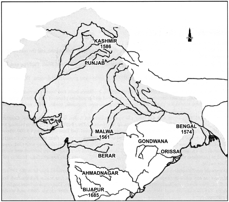
Map-Based Questions Class 7 History Chapter 4 The Mughal Empire

Question 1.
Find out military campaigns under Akbar and Aurangzeb:

  1. Kashmir
  2. Punjab
  3. Malwa
  4. Berar
  5. Ahmadnagar
  6. Bijapur
  7. Golconda
  8. Gondwana
  9. Orissa
  10. Bengal

Answer:
Class 7 History Chapter 4 Extra Questions and Answers The Mughal Empire

Class 7 Geography Chapter 3 Extra Questions and Answers Our Changing Earth

Our Changing Earth Class 7 Geography Chapter 3 Extra Questions and Answers Social Science CBSE Pdf free download are part of Extra Questions for Class 7 Social Science. Here we have given NCERT Extra Questions for Class 7 Social Science SST Geography Chapter 3 Our Changing Earth.

You can also practice NCERT Solutions for Class 7 Geography Chapter 3 Questions and Answers on LearnInsta.com.

Class 7 Geography Chapter 3 Extra Questions and Answers Our Changing Earth

Our Changing Earth Class 7 Extra Questions and Answer Geography Chapter 3 Very Short Answers Type

Question 1.
What are Lithospheric plates?
Answer:
The lithosphere is broken into a number of plates known as the Lithospheric plates.

Question 2.
How do the Lithospheric plates move?
Answer:
Lithospheric plates move because the molten magma moves inside the earth thereby the Lithospheric plates are moved very slowly just a few millimetres each year.

Question 3.
What is the result of movement of the Lithospheric plates?
Answer:
The movement of these plates causes changes on the surface of the earth.

Question 4.
What is volcano?
Answer:
A volcano is a vent (opening) in the earth’s crust through which molten material erupts suddenly.

Question 5.
What is earthquake?
Answer:
Vibration in the surface of earth is called earthquake.

Question 8.
What are distributaries?
Answer:
As the river approaches the sea, the speed of the flowing water decreases and the river begins to break up into a number of streams called distributaries.

Question 7.
How do the deltas form?
Answer:
Each distributary forms its own mouth. The collection of sediments from all the mouths forms a delta.

Question 8.
What are Glaciers?
Answer:
Glaciers are rivers of ice.

Question 9.
How are the glacial moraines formed?
Answer:
The material carried by the glaciers, such as rocks, sand and silt gets deposited. These deposits form glacial moraines.

Question 10.
Name the active agent of erosion and deposition in the deserts.
Answer:
The wind.

Question 11.
What do you understand about mushrooms rocks?
Answer:
In the desert areas, wind makes rocks in shape of a mushroom called mushroom rocks.

Our Changing Earth Class 7 Extra Questions and Answer Geography Chapter 3 Short Answers Type

Question 1.
What do you understand about endogenic and exogenic forces?
Answer:
The forces that act in the interior of the earth are called endogenic forces, while the forces that work on the surface of the earth are called exogenic forces. Endogenic forces sometimes produce sudden movements and at the other times produce slow move-ments. Sudden movements like earthquakes and volcanoes cause mass destruction over the surface of the earth.

Question 2.
How can the impact of earthquake be minimized?
Answer:
Although earthquake cannot be predicted but impact can be minimized. Selecting safe spot, staying away from fire places, chimneys etc., and be preparation are the measures which may be helpful as safeguards.

Question 3.
How are sea caves and sea arches formed?
Answer:
The erosion and deposition of the sea waves gives rise to coastal landforms. From the striking of sea waves to the rocks, hollow like caves are formed in the rocks which are called sea caves. When these cavities become bigger and bigger only the roof of the caves remains, thus forming sea arches.

Question 4.
What is focus and epicentre?
Answer:
The place in the crust where the movement starts is called the ‘focus’ and the place on the surface above the focus is called the ‘epicentre’. Greatest damage is usually closest to the epicentre and the strength of the earthquake decreases away from the centre.

Question 5.
How do the rivers erode the landscape?
Answer:The running water in the river erodes the landscape. Due to continuous erosion and deposition along the sides of the meander, the ends of the meander loop come closer and closer.

Question 6.
What is called sand dunes loess?
Answer:
In the desert areas, when the wind stops blowing, the sand falls and gets deposited in low hill like structures. These are called sand dunes. When the grains of sand are very fine and light, the wind can carry it over long distances, when such sand is deposited in large areas, it is called loess.

Our Changing Earth Class 7 Extra Questions and Answer Geography Chapter 3 Long Answers Type

Question 1.
What do you understand about seismograph? Describe in brief.
Answer:
An earthquake is measured with a machine called a seismograph. The magnitude of the earthquake is measured on the Richter scale. An earthquake of 2.0 or less can be felt only a little. When earthquake is measured over 5.0 on Richter scale, it can cause damage from falling things. A 6.0 or higher magnitude is considered very strong and 7.0 is classified as a major earthquake.

Question 2.
Write a short note on Waterfall.
Answer:
The running water in the river erodes the landscape. When the river tumbles at steep angle over very hard rocks or down a steep valley side it forms a waterfall.

There are thousands of small waterfalls in the world. The highest waterfall is Angel Falls of Venezuela in South America. The other waterfalls are Niagara falls located on the border between Canada and USA in North America and Victoria Falls on the borders of Zambia and Zimbabwe in Africa.
Class 7 Geography Chapter 3 Extra Questions and Answers Our Changing Earth 1
Picture Based Questions Class 7 Geography Chapter 3 Our Changing Earth

In the following picture, identify Sea Cave, Sea Arch and Stack.
Class 7 Geography Chapter 3 Extra Questions and Answers Our Changing Earth 2

Class 6 Geography Chapter 2 Extra Questions and Answers Globe Latitudes and Longitudes

Globe Latitudes and Longitudes Class 6 Geography Chapter 2 Extra Questions and Answers Social Science CBSE Pdf free download are part of Extra Questions for Class 6 Social Science. Here we have given NCERT Extra Questions for Class 6 Social Science SST Geography Chapter 2 Globe Latitudes and Longitudes.

You can also practice NCERT Solutions for Class 6 Geography Chapter 2 Questions and Answers on LearnInsta.com.

Class 6 Geography Chapter 2 Extra Questions and Answers Globe Latitudes and Longitudes

Globe Latitudes and Longitudes Class 6 Extra Questions and Answer Geography Chapter 2 Very Short Answers Type

Question 1.
What is the advantage of the globe?
Answer:
Globe is true model of the Earth. It depicts the whole Earth in small size. Globe provides us facility for the study of the Earth in easy way.

Question 2.
How does latitudes and longitudes help us?
Answer:
These help us to find out location on the Earth.

Question 3.
In which zone did the equator lie?
Answer:
Equator lies in the Torrid zone.

Question 4.
What is use of the Greenwich?
Answer:
Greenwich is used as a standard for time all over the world.

Question 5.
Where does the Tropic of Cancer lie?
Answer:
The Tropic of Cancer lies on 23 ¥2° N.

Question 6.
Where does Tropic of Capricorn lie?
Answer:
23 W S.

Question 7.
How much does the Earth rotate in 24 hrs.?
Answer:
Earth rotates 360° in 24 hrs.

Question 8.
How much time is required for the Earth for 1° rotation?
Answer:
Four hours.

Question 9.
Where is India located on the Globe?
Answer:
India is located east of Greenwich at 82°30 E.

Question 10.
By how much time is India ahead from Greenwich?
Answer:
5 hours 30 minutes.

Question 11.
How many zones has the Earth been divided?
Answer:
The Earth has been divided into 24 time zones.

Question 12.
In how many zones has the Earth been divided?
Answer:
24 time zones.

Globe Latitudes and Longitudes Class 6 Extra Questions and Answer Geography Chapter 2 Short Answers Type

Question 1.
Define Longitude.
Answer:
These are lines drawn on the globe by joining North Pole and South Pole. These lines run from north to south.

Question 2.
What do you understand by parallels of latitude?
Answer:
All parallel circles from the equator up to the poles are called parallels of latitudes. Latitudes are measured in degrees.

Question 3.
What do you understand by the Temperate Zone?
Answer:
The area between the Tropic of Cancer (23 V20 N) and the Arctic Circle (66 V20 S) in the Northern Hemisphere and the Tropic of Capricorn (23 W S) and the Antarctic Circle (66V20 S) in the Southern Hemisphere have moderate temperatures. These are therefore, called Temperate Zones.

Question 4.
Define the Northern and the Southern Hemisphere.
Answer:
An imaginary line running on the globe divides it into two equal parts. This line is known as the equator. The northern half part from the equator is called the Northern Hemisphere and southern half called the Southern Hemisphere.

Question 5.
Why did some countries adopt more than one standard time?
Answer:
Some countries have a great longitudinal extent and so they have adopted more than one standard time. For example, in Russia, there are as many as 11 standard times.

Globe Latitudes and Longitudes Class 6 Extra Questions and Answer Geography Chapter 2 Long Answers Type

Question 1.
Describe in brief the importance of parallels of latitudes.
Answer:
Equator:
An imaginary line running on the globe divides it into two equal parts. This is line which situated at 0° on the globe. Equator is surrounded by the Torrid Zone. In other words equator has its position in the middle of the Torrid Zone and this divided the Torrid Zone into two parts and expanded in north and south upto 23 V20 N & 23 V20 S.

Tropic of Cancer:
The Tropic of cancer line lies on 23 V20 N in the northern hemisphere. This area is expanded upto 66 V20 N. This area indicates about moderate temperature.

Tropic of Capricorn:
It is the parallel of 23 V20 S in the southern hemisphere.

Arctic Circle:
It lies at 66 V20 north of the equator.

Antarctic Circle:
It lies at 66 V20 south of the equator.

90° parallel:
It is shown by a point.
• its length is zero.

North Pole:
• it is 90° north of equator.

South Pole:
• it is at 90° south of equator.

Question 2.
Describe major heat zones of the Earth.
Answer:
Major heat zones are three:

1. Torrid zone: Torrid zone is a hot zone. This zones receive the maximum amount of heat throughout the year, because the rays of the Sun fall straightly on this zone. This zone is located between the Tropic of Cancer and the Tropic of Capricorn.

2. Temperate zone: Temperate zone is moderate temperature zone. The temperate zones lies between Arctic Circle and Tropic of Cancer in north and Tropic of Capricorn and Antarctic Circle in south. These zones are neither too hot nor too cold.

3. Frigid zone: Frigid zones are cold zones. Beyond the Arctic Circle and Antarctic Circle temperatures are very low and thus climate is very cold. This is due to the extreme slanting’s of the Sun’s rays.

The North Frigid Zone lies between the Arctic Circle (66 V2 °N) and North Pole in the northern hemisphere. The South Frigid Zone lies between the Antarctic Circle (66 V2 °S) and South Pole in the southern hemisphere.

Question 3.
How does longitudes help us to calculate the time?
Answer:
Time is measured by the movement of the Earth. The Earth is rotated on its axis. For one rotation, it takes 24 hours, it means the Earth is rotated 360° in 24 hrs. It means 15° in a hour or 1° in 4 minutes. Accordingly, the Earth has been divided into 24 time zones of one hour each.

The places which are situated in the east of Greenwich Meridian experience day or Sunrise earlier than the places lying west to the Greenwich Meridian. Thus, time is ahead in the east than the west places at the rate of 4 minutes per degree of longitude.

Picture Based Questions Class 6 Geography Chapter 2 Globe Latitudes and Longitudes

1. Draw important parallels of latitudes.
Class 6 Geography Chapter 2 Extra Questions and Answers Globe Latitudes and Longitudes 1

2. Draw Important Latitudes and Heat Zones.
Class 6 Geography Chapter 2 Extra Questions and Answers Globe Latitudes and Longitudes 2

Class 7 History Chapter 2 Extra Questions and Answers New Kings and Kingdoms

New Kings and Kingdoms Class 7 History Chapter 2 Extra Questions and Answers Social Science CBSE Pdf free download are part of Extra Questions for Class 7 Social Science. Here we have given NCERT Extra Questions for Class 7 Social Science SST History Chapter 2 New Kings and Kingdoms.

You can also practice NCERT Solutions for Class 7 History Chapter 2 Questions and Answers on LearnInsta.com.

Class 7 History Chapter 2 Extra Questions and Answers New Kings and Kingdoms

New Kings and Kingdoms Class 7 Extra Questions and Answer History Chapter 2 Very Short Answers Type

Question 1.
Why is the time span important between 7th to 12th centuries?
Answer:
The time span between 7th to 12th centuries is important because many new dynasties
emerged in different parts of the subcontinent.

Question 2.
Who were acknowledged as the ‘samantas’?
Answer:
In 7th century there were big landlords or warrior chiefs in different regions, they were acknowledged as subordinates or samantas of kings.

Question 3.
What was expected by the kings from samantas?
Answer:
Samantas were expected to bring gifts and provide them military support.

Question 4.
How did samantas become ‘maha-mandaleshvara’?
Answer:
As samantas gained power and wealth, they declared themselves to be maha-mandaleshvara.

Question 5.
Who were mah-samantas?
Answer:
The samantas who got power and wealth were also called ‘maha-samantas’.

Question 6.
What do you understand about ‘hiranya-garbha’?
Answer:
The Rashtrakutas in the Deccan were initially subordinate to the Chalukyas of Karnataka but later overthrew them and performed a ritual called ‘hiranya-garbha’. This ritual leads to the “rebirth” of the sacrificer as a Kshatria, even if he not one by birth.

Question 7.
Who was Kadamba Mayurasharman?
Answer:
The Kadamba Mayurasharman was Brahmana who gave up traditional profession and took to arm, successfully establishing kingdom in Karnataka.

Question 8.
Who was Pratihara Harichandra?
Answer:
The Gurjara Pratihara Harichandra was a Brahmana who gave up traditional professions and took to arms, successfully establishing kingdoms in Rajasthan.

Question 9.
How were resources obtained by the states?
Answer:
In each of these states resources were obtained from the producers, peasants, cattle keepers, artisans.

Question 10.
Where did the Cholas ruled?
Answer:
The Cholas were in Tamil Nadu.

Question 11.
How many taxes were imposed in the Cholas regime?
Answer:
There were more than 400 kinds of taxes in the Cholas regime.

Question 12.
What do you understand about ‘vetti’?
Answer:
In the Cholas regime, the most frequently mentioned tax is ‘vetti’ taken not in cash but in the form of forced labour.

Question 13.
What do you understand by word ‘kadamai?
Answer:
‘Kadamai’ was tax of the Cholas regime imposed for land revenue.

Question 14.
What was the use of collected taxes?
Answer:
The collected taxes were used for the construction of temples and forts, to fight wars, and access to land as well as trade routes.

Question 15.
What was referred in prashasti found in Gwalior, Madhya Pradesh?
Answer:
One prashasti written in Sanskrit and found in Gwalior, Madhya Pradesh describes the exploits of Nagabhata, a Pratihara King.

Question 16.
Mention the use of copper plates during the period.
Answer:
Kings often rewarded Brahmanas by grants of land. These were recorded on copper plates, which were given to those who received the land.

Question 17.
Where did the Chauhans ruled?
Answer:
The Chauhans ruled over the region around Delhi and Ajmer.

Question 18.
What was the target of Sultan Mahmud of Ghazni?
Answer:
He raided the subcontinent almost every year. His targets were wealthy temples, including that of Somnath, Gujarat.

Question 19.
Who wrote ‘Kitab-al-Hind’?
Answer:
Al-Biruni wrote it.

Question 20.
Who captured delta from the Muttaraiyar?
Answer:
Vijayalaya, who belonged to the ancient chiefly family of the Cholas from Uraiyur captured the delta from the Muttaraiyar in the middle of the ninth century.

Question 21.
Who built Thanjavur and a temple for goddess Nishumbhasudini?
Answer:
Vijayalaya Chola built the town named Thanjavur.

Question 22.
Who conquered the Pandyan and the Pallava territories?
Answer:
Vijayalaya conquered the Pandyan and the Pallava territories.

Question 23.
Who built temples of Thanjavur and Gangaikonda Cholapuram?
Answer:
The temples of Thanjavur and Gangaikonda Cholapuram were built by Rajaraja and Rajendra.

Question 24.
How many sabhas were formed by the Cholas for the regulation of various works?
Answer:
Inscription received from Tamil Nadu, provide the details of various sabha such as irrigation
works, gardens, temples etc., with a certain criteria of eligibility.

New Kings and Kingdoms Class 7 Extra Questions and Answer History Chapter 2 Short Answers Type

Question 1.
What do you meant by maharaja-adhiraja, tribhuvana-chakravartin?
Answer:
The meaning of maharaja-adhiraja and tribhuvana-chakravartin are ‘great king’ and ‘Lord of the three worlds’ respectively. Many of the new kings adopted high sounding titles such as maharaja-adhiraja and tribhuvana-chakravartin. They often shared power with their samantas as well as with associations of peasants, traders and Brahmanas.

Question 2.
Who collected the taxes?
Answer:
For collecting the taxes or revenue functionaries were generally recruited from influential families and positions were often hereditary. In many cases, close relatives of the king held
these positions.

Question 3.
What do you understand by ‘tripartite struggle’?
Answer:
In the Ganga valley, city of Kanauj was the area where three dynasties fought for control. These dynasties were

  1. Guijara-Pratihara
  2. Rashtrakuta and
  3. Pala dynasties.

Historians often describe it as the ‘tripartite struggle’.

Question 4.
What attempts were made to expand the regime by the Chauhans?
Answer:
The Chauhans attempted to expand their control to the west and the east, where they were opposed by the Chalukyas of Gujarat and the Gahadavalas of western Uttar Pradesh. The best known Chauhans ruler was Prithviraja III (1168-1192), who defeated an Afghan ruler name Sultan Muhammad Ghori in 1191, but next year in 1192 he was defeated by Ghori.

Question 5.
How did the rulers demonstrate their power and resources?
Answer:
Rulers tried to demonstrate their power and resources by building large temples. So, when they attacked, they often chose to target temples, which were sometimes extremely rich.

Question 6.
When and where did Sultan Mahmud of Ghazni ruled?
Answer:
Sultan Mahmud of Ghazni, Afghanistan ruled from 997 to 1030 and extended control over parts of Central Asia, Iran and the north-western part of the subcontinent.

Question 7.
How were the temples hubs for economic, social and cultural life?
Answer:
Temples and its area were maintained by those who worked at the temple and very often lived near it, priests, garland makers, cooks, sweepers, musicians, dancers, etc. In other words, temples were not only places of worship; they were the hub of economic, social and
cultural life as well.

Question 8.
Describe the development of agriculture in Cholas regime.
Answer:
Many of the achievements of the Cholas were made possible through new developments in agriculture. The Kaveri branches off into several channels before emptying into the Bay of Bengal. Water from the channels also provides the necessary moisture for agriculture particularly the cultivation of rice.

New Kings and Kingdoms Class 7 Extra Questions and Answer History Chapter 2 Long Answers Type

Question 1.
How did the new dynasties emerge?
Answer:
By the 7th century there were big landlords or warrior chiefs in different regions of the subcontinent. The kings often acknowledged them as their subordinates or samantas. These samantas provided gifts and military support to the king. As samantas gained power and wealth, they declared themselves to be maha- samanta or maha-mandaleshvara and so on. Sometimes they asserted their independence from their overlords.

As an example, Rashtrakutas were subordinate to the Chalukyas of Karnataka overthrew his Chalukya overlord and performed a ritual called hiranya-garbha. Likewise, Kadamba Mayurasharman and the Gurjara Pratihara Harichandra were Brahmanas who gave up their traditional professions and took to arms, successfully establishing kingdoms in Karnataka and Rajasthan respectively. Thus, a new dynasty emerged.

Question 2.
How did the kingdoms obtained resources?
Answer:
During the period, the kings often shared their power with their samantas as well as associations of peasants, traders and BrahmAnswer:Resources were obtained from producers such as peasants, cattle keepers, artisans etc. In the Cholas regime there were more than 400 taxes.

Vetti was taken not in cash but in the form of forced labour and kadamai or land revenue. There were also tax on house, the use of a ladder to climb palm trees, a cess on succession to family property etc. These resources were used to finance the king’s establishment, construction of temples and forts also used to fight wars.

Picture Based Questions Class 7 History Chapter 2 New Kings and Kingdoms

Class 7 History Chapter 2 Extra Questions and Answers New Kings and Kingdoms 1
Question 1.
Look the temple given and give the answer:

  1. Who built this temple and when?
  2. Who and when built this temple?
  3. Where is this situated?
  4. To whom is temple dedicated?

Answer:

  1. Gangaikonda temple.
  2. The temple was built by Rajendra in 1035 AD. Rajendra was a king of Chola dynasty.
  3. Situated in Cholapuram, Distt.: Ariyalur Tamil Nadu.
  4. Mainly dedicated to Bhagwan Shiva.

Map-Based Questions Class 7 History Chapter 2 New Kings and Kingdoms

Question 1.
In the given map locate the followings Regimes:
(i) Cholas Regime
(ii) Palas Regime
(iii) Rashtrakutas Regime
(iv) Chauhans Regime
Answer:
Class 7 History Chapter 2 Extra Questions and Answers New Kings and Kingdoms 2

Class 6 Geography Chapter 8 Extra Questions and Answers India: Climate Vegetation and Wildlife

India: Climate Vegetation and Wildlife Class 6 Geography Chapter 8 Extra Questions and Answers Social Science CBSE Pdf free download are part of Extra Questions for Class 6 Social Science. Here we have given NCERT Extra Questions for Class 6 Social Science SST Geography Chapter 8 India: Climate Vegetation and Wildlife.

You can also practice NCERT Solutions for Class 6 Geography Chapter 8 Questions and Answers on LearnInsta.com.

Class 6 Geography Chapter 8 Extra Questions and Answers India: Climate Vegetation and Wildlife

India: Climate Vegetation and Wildlife Class 6 Extra Questions and Answer Geography Chapter 8 Very Short Answers Type

Question 1.
What are the reasons of change in weather?
Answer:
Due to changes in temperature, rainfall and sunshine etc., day to day weather is also changed.

Question 2.
Mention the types of weather?
Answer:
The weather may be hot or cold; sunny or cloudy; windy or calm.

Question 3.
How many seasons are there in India?
Answer:
Four. Winter, summer, rainy and autumn.

Question 4.
How do we experience winter season?
Answer:
The Sun rays do not fall directly in the region. As a result the temperature is quite low in northern India and thus, the people of the region feel cold.

Question 5.
In which season do the Sun rays fall directly?
Answer:
In summer season.

Question 6.
What is another name of “South West Monsoon Season”?
Answer:
“South West Monsoon Season” is also called rainy season.

Question 7.
Where does air blow in rainy season?
Answer:
In the rainy season, the winds blow from Arabian Sea and Bay of Bengal towards the land.

Question 8.
How is rainfall carried by the winds?
Answer:
When South West winds strike the mountain barriers, rainfall occurs. The air carries moisture with it.

Question 9.
In which places does rainfall occur in autumn?
Answer:
In the southern part of India particularly, Tamil Nadu and Andhra Pradesh receive rainfall in this season.

Question 10.
Which air blows in the autumn season?
Answer:
In autumn season winds move back from the mainland to the Bay of Bengal.

Question 11.
Write the factors which affect climate.
Answer:
The climate of India is affected by its location, altitude (height), distance from sea and relief.
Therefore, we experience regional differences in the climate of India.

Question 12.
Which are the hot desert places in India?
Answer:
Jaisalmer and Bikaner in the desert of Rajasthan are very hot.

Question 13.
Which are the cold places in India?
Answer:
Drass and Kargil in Jammu and Kashmir are freezing cold.

Question 14.
Which places of India have moderate climate?
Answer:
Coastal places like Mumbai and Kolkata experience moderate climate.

Question 15.
Give the name of place receiving highest rainfall.
Answer:
Mawsynram in Meghalaya receives the world’s highest rainfall.

Question 16.
When do trees shed their leaves in Tropical Rain Forests?
Answer:
The trees shed their leaves at different time of the year. These always appear green.

Question 17.
Which trees grow in Tropical deciduous forests?
Answer:
Important trees of these forests are sal, teak, peepal, neem and shisham.

Question 18.
When do trees shed their leaves in tropical deciduous forests?
Answer:
They shed their leaves at a particular time of the year.

Question 19.
Where is Sunderbans located?
Answer:
In West Bengal.

Question 20.
What do you mean by Sundari?
Answer:
Sundari is a well-known species of trees in Mangrove forests after which Sunderbans have been named.

Question 21.
Where are sal, teak, peepal, neem and shisham found?
Answer:
These are found in Tropical Deciduous Forests.

Question 22.
Name of places where thorny bushes vegetation is found.
Answer:
These are found in the states of Rajasthan, Punjab, Haryana, eastern slopes of Western Ghats and Gujarat.

Question 23.
Name of our National animal.
Answer:
Our National animal is ‘Tiger’.

Question 24.
Which are the animals found in the forests of Assam?
Answer:
Elephants and one-horned rhinoceroses are found in Assam.

Question 25.
Where are camels found?
Answer:
Camels found in Great Indian desert.

Question 26.
Which animals are found in the Himalayan region?
Answer:
Wild goats, snow leopards, bears etc., are found in the Himalayan region.

India: Climate Vegetation and Wildlife Class 6 Extra Questions and Answer Geography Chapter 8 Short Answers Type

Question 1.
Which are the major seasons in India?
Answer:
The major seasons recognized in India are:

  1. Winter which falls from December to February;
  2. Summer falls from March to May;
  3. Rainy season falls from June to September;
  4. Autumn falls from October to November.

Question 2.
State different type of Vegetation found in India.
Answer:
Vegetation of India can be divided into five types-

  1. Tropical evergreen or rain forest,
  2. Tropical deciduous forest,
  3. Thorny bushes,
  4. Mountain vegetation and
  5. Mangrove forest.

Question 3.
Which are the species found in Tropical Rain Forests? Give location thereof.
Answer:
Mahogany, ebony and rosewood are trees found in Tropical Rain Forests. Andaman and Nicobar Islands, parts of north-eastern States and a narrow strip of the western slope of the Western Ghats are home of these forests.

Question 4.
Why doesn’t Sunlight reach up to the ground in Tropical Rain Forests?
Answer:
The sunlight doesn’t reach upto the ground in Tropical Rain Forests because the rainfall being heavy, vegetation in these areas are very dense and hence it is not possible for sunlight to reach upto the ground.

Question 5.
Where do we find Tropical deciduous forests?
Answer:
These are found in a large part of our country such as in Madhya Pradesh, Uttar Pradesh, Bihar, Jharkhand, Chhattisgarh, Odisha, and in parts of Maharashtra.

Question 6.
What do you understand about thorny bushes vegetation?
Answer:
Thorny bushes vegetation is found in dry areas of the country. The leaves are in the form of spines to reduce the loss of water. Cactus, khair, babool, keekar are important and are found in the states
of Rajasthan, Punjab, Haryana, eastern slopes of Western Ghat and Gujarat.

Question 7.
Write few lines on Mountain Vegetation.
Answer:
A wide range of Mountain vegetation is found in the mountains according to the variation in height. At a height between 1500 to 2500 metres, most of the trees are conical in shape. These trees are called coniferous trees. Chir, Pine and Deodar are important trees of these forests.

Question 8.
Why is wildlife declining rapidly in India? What efforts have been made by the government in this regard?
Answer:
Due to cutting of forests and hunting, several species of wildlife of India are declining rapidly. Many species have already become extinct. In order to protect the wildlife many national parks, sanctuaries and biosphere reserves have been set up by the government. The government has also started Project Tiger and Project Elephant to protect these animals.

Question 9.
What do you understand about coniferous trees?
Answer:
At a height of 1500 to 2500 metres, where mountain vegetation exist, most of trees are conical in shape. These trees are called coniferous trees. Chir, Pine and Deodar are some examples of coniferous trees.

India: Climate Vegetation and Wildlife Class 6 Extra Questions and Answer Geography Chapter 8 Long Answers Type

Question 1.
What do you understand about the seasons? Describe them.
Answer:
Due to changes in temperature, rainfall and sunshine etc., day to day weather is also changed. This specific weather is called season.

  1. Winter season: This is also called “Cold Weather Season”. The Sunrays do not fall directly in the region. As a result the temperature is quite low in northern India.
  2. Summer season: This is also called “hot weather season”. In this season Sun rays more or less directly fall in this region. Temperature becomes very high. Hot and dry winds called loo, blow during the day.
  3. Rainy season: This is also called “South West Monsoon Season”. In this season the winds blow from Arabian Sea and Bay of Bengal towards the land. These winds carry moisture with them. When these winds strike the mountain barriers, rainfall occurs.
  4. Autumn: This is also called “Season of Retreating Monsoons”. In this season winds move back from the mainland to the Bay of Bengal. The southern part of India particularly Tamil Nadu and Andhra Pradesh receive rainfall in this season.

Question 2.
Describe different type of vegetation found in India.
Answer:
Tropical rain: Tropical forests occur in the areas which receive heavy rainfall. They are so dense that Sunlight doesn’t reach the ground. Many species of trees are found in these forests. The trees shed their leaves at different time of the year. These always appear green.

Mahogany, ebony and rosewood are trees found in these areas. Andaman and Nicobar Islands, parts of north-eastern states and a narrow strip of the western slope of the Western Ghats are home of these forests.

Tropical deciduous forests: These forests are found in a large part of our country. These forests are also called monsoon forests. They are less dense. They shed their leaves at a particular time of the year.

Important trees of these forests are sal, teak, peepal, neem and shisham. They are found in Madhya Pradesh, Uttar Pradesh, Bihar, Jharkhand, Chhattisgarh, Odisha, and in parts of Maharashtra.

Thorny bushes vegetation: These are found in dry areas of the country. The leaves are in the form of spines to reduce the loss of water. Cactus, khair, babool, keekar are important and are found in the States of Rajasthan, Punjab, Haryana, eastern slopes of Western Ghat and Gujarat.

Mountain vegetation: A wide range of Mountain vegetation is found in the mountains according to the variation in height. At a height between 1500 to 2500 metres. Most of the trees are conical in shape. These trees are called coniferous trees. Chir, Pine and Deodar are important trees of these forests.

Mangrove forests: These forests can survive in saline water. They are found mainly in Sunderbans in West Bengal and in the Andaman and Nicobar Islands. Sundari is a well-known species of trees in mangrove forests after which Sunderbans have been named.

Question 3.
Why are forests necessary? Describe.
Answer:
Forests are very useful for us. They perform various functions. Some of them can be summarized as follows:

  1. Plants release oxygen that we breathe and carbon dioxide released by living being is absorbed by the plants, thus these make a balance in oxygen and carbon dioxide.
  2. The roots of the plants bind the soil; thus, they control soil erosion.
  3. Forests provide us timber, fuel, wood, fodder, medicinal plants and herbs, lac, honey, gum etc.
  4. Forests are the natural habitat of wildlife.
  5. Forests control over rain.
  6. Used in industrial produces etc.

Question 4.
Write a short note on wildlife in India.
Answer:
Forests are home to a variety of wildlife. There are many species of animals and a large variety of reptiles, amphibians, mammals, birds, insects and worms which dwell in the forest.

Tiger is our National Animal. Gir forest in Gujarat is a home Asiatic lions. Elephants and one-horned rhinoceroses roam in the forests of Assam. Elephants are also found in Kerala and Karnataka. Camels are found in the Great India desert and wild asses in the Rann of Kuchchh. Wild goats, snow leopards, bears are found in the Himalayan region. Many other animals are found in our country such as monkeys, wolves, jackals, nilgais, cheetals etc.

Peacock is our National Bird. There are several birds found in our country. Other common birds are parrots, pigeons, mynah, geese, bulbul and ducks. There are several bird sanctuaries which have been created to give birds their natural habitat. These provide the birds protection from hunters.

There are several hundreds of species of snakes found in India. Cobras and Kraits are important among them. In order to protect animals, the government has also started Project Tiger and Project Elephant.

Picture Based Questions Class 6 Geography Chapter 8 India: Climate Vegetation and Wildlife

1. Find out following National Parks in the Map of India.
(i) Gir
(ii) Kaziranga
(iii) Dachigam
(iv) Dudhwa
(v) Corbet

2. Find out following Wildlife Sanctuaries in the Map of India.
(i) Sariska
(ii) Pocharam
(iii) Chandra Prabha
(iv) Periyar
(v) Eturnagaram
Answer:
Class 6 Geography Chapter 8 Extra Questions and Answers India Climate Vegetation and Wildlife