Globe Latitudes and Longitudes Class 6 Geography Chapter 2 Extra Questions and Answers Social Science CBSE Pdf free download are part of Extra Questions for Class 6 Social Science. Here we have given NCERT Extra Questions for Class 6 Social Science SST Geography Chapter 2 Globe Latitudes and Longitudes.
You can also practice NCERT Solutions for Class 6 Geography Chapter 2 Questions and Answers on LearnInsta.com.
Class 6 Geography Chapter 2 Extra Questions and Answers Globe Latitudes and Longitudes
Globe Latitudes and Longitudes Class 6 Extra Questions and Answer Geography Chapter 2 Very Short Answers Type
Question 1.
What is the advantage of the globe?
Answer:
Globe is true model of the Earth. It depicts the whole Earth in small size. Globe provides us facility for the study of the Earth in easy way.
Question 2.
How does latitudes and longitudes help us?
Answer:
These help us to find out location on the Earth.
Question 3.
In which zone did the equator lie?
Answer:
Equator lies in the Torrid zone.
Question 4.
What is use of the Greenwich?
Answer:
Greenwich is used as a standard for time all over the world.
Question 5.
Where does the Tropic of Cancer lie?
Answer:
The Tropic of Cancer lies on 23 ¥2° N.
Question 6.
Where does Tropic of Capricorn lie?
Answer:
23 W S.
Question 7.
How much does the Earth rotate in 24 hrs.?
Answer:
Earth rotates 360° in 24 hrs.
Question 8.
How much time is required for the Earth for 1° rotation?
Answer:
Four hours.
Question 9.
Where is India located on the Globe?
Answer:
India is located east of Greenwich at 82°30 E.
Question 10.
By how much time is India ahead from Greenwich?
Answer:
5 hours 30 minutes.
Question 11.
How many zones has the Earth been divided?
Answer:
The Earth has been divided into 24 time zones.
Question 12.
In how many zones has the Earth been divided?
Answer:
24 time zones.
Globe Latitudes and Longitudes Class 6 Extra Questions and Answer Geography Chapter 2 Short Answers Type
Question 1.
Define Longitude.
Answer:
These are lines drawn on the globe by joining North Pole and South Pole. These lines run from north to south.
Question 2.
What do you understand by parallels of latitude?
Answer:
All parallel circles from the equator up to the poles are called parallels of latitudes. Latitudes are measured in degrees.
Question 3.
What do you understand by the Temperate Zone?
Answer:
The area between the Tropic of Cancer (23 V20 N) and the Arctic Circle (66 V20 S) in the Northern Hemisphere and the Tropic of Capricorn (23 W S) and the Antarctic Circle (66V20 S) in the Southern Hemisphere have moderate temperatures. These are therefore, called Temperate Zones.
Question 4.
Define the Northern and the Southern Hemisphere.
Answer:
An imaginary line running on the globe divides it into two equal parts. This line is known as the equator. The northern half part from the equator is called the Northern Hemisphere and southern half called the Southern Hemisphere.
Question 5.
Why did some countries adopt more than one standard time?
Answer:
Some countries have a great longitudinal extent and so they have adopted more than one standard time. For example, in Russia, there are as many as 11 standard times.
Globe Latitudes and Longitudes Class 6 Extra Questions and Answer Geography Chapter 2 Long Answers Type
Question 1.
Describe in brief the importance of parallels of latitudes.
Answer:
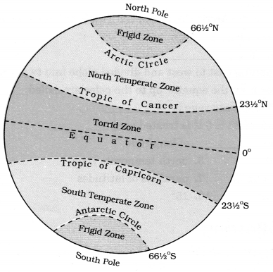
Equator:
An imaginary line running on the globe divides it into two equal parts. This is line which situated at 0° on the globe. Equator is surrounded by the Torrid Zone. In other words equator has its position in the middle of the Torrid Zone and this divided the Torrid Zone into two parts and expanded in north and south upto 23 V20 N & 23 V20 S.
Tropic of Cancer:
The Tropic of cancer line lies on 23 V20 N in the northern hemisphere. This area is expanded upto 66 V20 N. This area indicates about moderate temperature.
Tropic of Capricorn:
It is the parallel of 23 V20 S in the southern hemisphere.
Arctic Circle:
It lies at 66 V20 north of the equator.
Antarctic Circle:
It lies at 66 V20 south of the equator.
90° parallel:
It is shown by a point.
• its length is zero.
North Pole:
• it is 90° north of equator.
South Pole:
• it is at 90° south of equator.
Question 2.
Describe major heat zones of the Earth.
Answer:
Major heat zones are three:
1. Torrid zone: Torrid zone is a hot zone. This zones receive the maximum amount of heat throughout the year, because the rays of the Sun fall straightly on this zone. This zone is located between the Tropic of Cancer and the Tropic of Capricorn.
2. Temperate zone: Temperate zone is moderate temperature zone. The temperate zones lies between Arctic Circle and Tropic of Cancer in north and Tropic of Capricorn and Antarctic Circle in south. These zones are neither too hot nor too cold.
3. Frigid zone: Frigid zones are cold zones. Beyond the Arctic Circle and Antarctic Circle temperatures are very low and thus climate is very cold. This is due to the extreme slanting’s of the Sun’s rays.
The North Frigid Zone lies between the Arctic Circle (66 V2 °N) and North Pole in the northern hemisphere. The South Frigid Zone lies between the Antarctic Circle (66 V2 °S) and South Pole in the southern hemisphere.
Question 3.
How does longitudes help us to calculate the time?
Answer:
Time is measured by the movement of the Earth. The Earth is rotated on its axis. For one rotation, it takes 24 hours, it means the Earth is rotated 360° in 24 hrs. It means 15° in a hour or 1° in 4 minutes. Accordingly, the Earth has been divided into 24 time zones of one hour each.
The places which are situated in the east of Greenwich Meridian experience day or Sunrise earlier than the places lying west to the Greenwich Meridian. Thus, time is ahead in the east than the west places at the rate of 4 minutes per degree of longitude.
Picture Based Questions Class 6 Geography Chapter 2 Globe Latitudes and Longitudes
1. Draw important parallels of latitudes.
2. Draw Important Latitudes and Heat Zones.