CBSE Class 10 Geography Chapter 7 Extra Questions and Answers Lifelines of National Economy Pdf free download are part of Extra Questions for Class 10 Social Science. Here we have given NCERT Extra Questions for Class 10 Social Science SST Geography Chapter 7 Lifelines of National Economy.
Learnintsa.com Committed to provides Extensive NCERT Solutions for Class 10 Geography Chapter 7 Lifelines of National Economy, Students can read and score more marks in your CBSE board examination.
Lifelines of National Economy Class 10 Extra Questions Geography Chapter 7
VERY SHORT ANSWER QUESTIONS
Answers should not exceed 30 words.
Question 1.
Why is there the need for transport system ? Mention any one reason.
Answer:
The movement of goods and products from the supply locations to demand locations (markets) necessitates the need for transport.
Question 2.
Which are the different types of transport ?
Answer:
The transport can be classified into land, water and, air transport.
Question 3.
Mention two types of airways.
Answer:
Domestic Airways and International Airways.
Question 4.
What are the factors for growing importance of the roadways ? State two factors.
Answer:
- Construction cost of roads is much lower than that of railway lines.
- It provides door-to-door service.
Question 5.
How are roads classified in India ?
Answer:
In India roads are classified into six classes as mentioned below :
- Golden Quadrilateral Super Highways
- National Highways
- State Highways
- District Roads
- Other roads that link rural areas with towns
- Border Roads.
Question 6.
What is road density ?
Answer:
The length of road per 100 sq. km of area is known as density of roads.
Question 7.
What was national average density of roads in 1996-97 ?
Answer:
The national average density of roads in India in 1996-97 was 75 km per 100 sq. km.
Question 8.
Mention one drawback of roads in India.
Answer:
Most of the bridges and culverts are old and narrow.
Question 9.
When and where the first train steamed off in India ?
Answer:
In India, the first train steamed off from Mumbai to Thane in 1853, covering a distance of 34 km.
Question 10.
The northern plains provide favourable conditions for the growth of the railways. Mention any two.
Answer:
- Vast level land.
- High population density.
Question 11.
Why railway track are laid with difficulty in Rajasthan ?
Answer:
It is difficult to lay railway lines on the sandy plain of Rajasthan.
Question 12.
In recent times which railway has been developed along the west coast ?
Answer:
Konkan Railway.
Question 13.
The railways is facing many problems. Mention any two problems.
Answer:
- Many passengers travel without ticket.
- People pull the chain unnecessarily.
Question 14.
What is the use of pipelines transport ?
Answer:
Pipelines are used for transporting crude oil, petroleum products and natural gas from oil and natural gas fields to refineries, fertilizer factories and big thermal power plants.
Question 15.
There are three important networks of pipeline transportation in the country. Mention any one.
Answer:
Gas pipeline from Hazira in Gujarat connects Jagdishpur in Uttar Pradesh via Vijaipur in Madhya Pradesh. It has branches to Kota in Rajasthan, Shahjahanpur, Babrala and other places in Uttar Pradesh.
Question 16.
Why are the waterways useful ? State any two advantages.
Answer:
- Waterways are the cheapest means of transport.
- It is a fuel efficient and environment friendly mode of transport.
Question 17.
Which waterways have been declared as National Waterways by the government ?
Answer:
- The Ganga river between Allahabad and Haldia (1620 km) NW No. 1.
- The Brahmaputra river between Sadiya and Dhubri (891 km) NW No. 2.
- The West-Coast Canal in Kerala (205 km) NW No. 3.
Question 18.
What is the length of India’s coastline ?
Answer:
7516.6 km.
Question 19.
Which port was the first port developed after independence and why ?
Answer:
Kandla in Kuchchh was the first port developed after independence to ease the volume of trade on Mumbai port in the wake of loss of Karachi port of Pakistan after the Partition.
Question 20.
Which is the biggest port ? State its one feature.
Answer:
- Mumbai is the biggest port.
- It has a spacious, natural and well-sheltered harbour.
Question 21.
Which is the premier iron ore exporting port of the country ?
Answer:
Marmagao (Goa) is the premier iron ore exporting port of the country.
Question 22.
Which is one of the oldest artificial port in the country ?
Answer:
Chennai is one of the oldest artificial ports of the country.
Question 23.
What type of port is Kolkata ?
Answer:
Kolkata is an inland riverine port.
Question 24.
State one feature of Airways.
Answer:
Airways is the fastest, most comfortable and prestigious mode of transport.
Question 25.
Which is the extreme south-western port located at the entrance of a lagoon with a natural harbour ?
Answer:
Kochchi.
Question 26.
When was air transport nationalised ?
Answer:
In 1953.
Question 27.
Which company provides helicopter services to ONGC and where ?
Answer:
Pawanhans Helicopters Ltd. provides helicopter services to Oil and Natural Gas Commission in its far off-shore operations.
Question 28.
In which states special provisions have been made to provide air services to the common people ?
Answer:
It is only in the north-eastern states that special provisions are made to extend the air services to the common people.
Question 29.
How many telephone exchanges are there in India ?
Answer:
About 37565.
Question 30.
How many villages are covered with STD telephone facility in India ?
Answer:
More than two-thirds villages in India have already been covered with Subscriber Trunk Dialing (STD) telephone facility.
Question 31.
What is trade ?
Answer:
The exchange of goods among people, states and countries is referred to as trade.
Question 32.
Which states are important destinations of foreign tourists in India ?
Answer:
Rajasthan, Goa, Jammu and Kashmir and Temple towns of south India.
QUESTIONS OF &S MARKS
Answers should he in about 80/100 words.
Question 1.
“Efficient means of transport are pre-requisites for the fast development.” Express your views in favour of this statement. [CBSE 2016]
Answer:
I agree with the above statement. Without efficient means of transport, no development can be made in a country. The arguments in favour of the statement are as mentioned below :
- The goods and services do not move from supply locales to demand locales on their
own. - The movement of goods and services from supply locations to demand locations necessitates the need for transport.
- A large number of workers are engaged in doing this work so that the needs of people may be fulfilled.
- Traders too use transport facilities for sending and receiving goods for selling to the consumers.
- If no transport facility is available, they may not be able to send their goods and products to different places. Their trade will, thus, be concentrated to one place only. The pace of development of a country, thus, depends upon the production and movement of goods and services to all the parts.
Question 2.
Do you agree with the view that transport, communication and trade are complementary to each other ? Explain you views.
Answer:
Yes, means of transport, communication and trade are complementary to each other as mentioned below :
- Transport and communication provide the infrastructural basis for conducting trade.
- The growth in trade also leads to creation of more infrastructure to match the volume of trade because increase in the volume of trade may need more means of transport.
- More trade creates avenue for investment in infrastructure through the revenue generated by trade.
- The growth in trade means more transport like roads, railways, air, water and pipelines to be developed to keep the wheels of economy moving.
- Communication helps in commercial transactions to be completed across different places all over the world. It helps to cross the geographical barriers and keeps the traders informed about their business instantly. The modern means of communication such as e-mail, mobile etc. are of great help for the traders all over the world. The world has become a village.
Thus it can be said that progress in science, technology, means of transport and communication are responsible for increase in trade and commerce.
Question 3.
“Roadways still have an edge over railways in India.” Support the statement with arguments.
[CBSE 2016]
Answer:
See Textbook Question 2(1) and (2).
Question 4.
Describe different kinds of roads according to their capacity.
Answer:
The roads are classified into six classes according to their capacity as mentioned below :
(1) Golden Quadrilateral Super Highways :
- It is a major road development project linking Delhi-Kolkata-Chennai-Mumbai and Delhi by six-lane Super Highways.
- The object of these Super Highways is to meet the requirements of fast movement of traffic in the country and to reduce the time and distance between the mega cities of India.
- North-South corridor connects Srinagar (JK) to Kanniyakumari (Tamil Nadu).
- East-West corridor connects Silchsr, (Assam) to Porbandar (Gujarat).
- These highway projects are being implemented by the National Highway Authority of
India (NHAI). ”
(2) National Highways :
- National Highways link extreme parts of the country including one state with another.
- These are primary road systems of national importance. Therefore, these are con¬structed and maintained by the Central Public Works Department (CPWD) of the central government.
The historical Sher Shah Suri Marg is called National Highway No. 1 between Delhi and Amritsar. - A number of major National Highways run in North-South and East-West directions.
(3) State Highways :
- These roads link a state capital with different district headquarters.
- These roads are constructed and maintained by the State Public Works Department in State and Union Territories.
(4) District Roads :
- These roads connect the district headquarters with other places of the district.
- These roads are maintained by the Zila Parishad.
(5) Rural Roads :
- Rural roads or village roads link rural areas and villages with towns.
- Under Pradhan Mantri Grameen Sadak Yojana provisions have been made to link every village in the country to a major town by an all season motorable road. Thus, it is hoped that the condition of rural roads will improve in future.
(6) Border Roads :
- These roads are in the border areas of the country.
- Border Roads Organisation which is a Government of India undertaking constructs and maintains these roads.
- These roads are of strategic importance in the northern and north-eastern border areas.
- These roads have improved accessibility in areas of difficult terrain.
- These roads have also helped in the economic development of these areas.
Question 5.
How roads are classified on the basis of the type of material used for their construction ?
Answer:
On the basis of type of material use for their construction, roads are classified into two types as mentioned below :
(1) Metalled roads :
- These roads are made of cement concrete or even bitumen or coal tar.
- One can go fast on metalled roads.
- These are all weather roads.
- These are maintained by the government.
(2) Unmetalled roads :
- These are not all weather roads.
- These are made of mud and gravel which are generally found in the rural areas.
- These are sometimes made even of sand and laid as extended roads.
- These may not be fit for use in rainy season.
- The unmetalled roads are maintained by common people.
- One cannot go fast on these roads.
Question 6.
Describe the problems that are being faced in road transportation in India.
Answer:
The problems that are being faced in road transportation in India are as given below :
- Inadequate network in view of the volume of traffic and passengers.
- Half of the roads are unmetalled that cannot be used during rainy season.
- National highways are inadequate to meet the rush of traffic.
- Roads in the cities are highly congested.
- Most of the bridges and culverts are old and narrow.
- Roadside amenities like emergency health services, police protection on the highways are not adequate.
The above problems need immediate attention of the government to make road transport more popular and useful in the country.
Question 7.
“Railways are the principal mode of transportation in India.” Explain.
Answer:
The railways are the main artery of inland transport in India. It is the lifeline of the country as mentioned below :
- Railways are the principal mode of transportation for freight and passengers.
- The Indian Railways have a network of 7,031 stations, 7,817 locomotives, 5,321 passenger service vehicles, 4,904 other coach vehicles and 228,170 wagons as on 31st March, 2004.
- The total length of railways is 63,221 km.
- Railways are useful in conducting business, sightseeing, pilgrimage along with transportation of goods over longer distances.
- It is the largest public undertaking in the country. Thus, it is clear that the railways are playing an important role in our economy. It has played an important role in the integration of the country as people can go from one region to another easily.
Question 8.
Give brief description of the Indian Railway’s gauge operations.
Answer:
A table showing Indian Railway’s Track on multiple gauge operations is given below
(Source : India Year Book, 2006)
| Gauge in metres | Route (km) | Running Track (km) | Total Track (km) |
(1) Broad Gauge (1.676) (2) Meter Gauge (1.000) (3) Narrow Gauge (0.762 & 0.610) | 46,807 13,209 3,124 | 66,754 13,976 3,129 | 88,517 16,489 3,450 |
| Total | 63,221 | 83,859 | 1,08,486 |
Question 9.
Analyse the physiographic and economic factors that have influenced the distribution pattern of railway network in our country. [CBSE 2015]
Answer:
Physical and economic factors have influenced the distribution pattern of the Indian Railway network in the following ways :
(1) Northern plains :
- Level land, high population density and rich agricultural re¬sources has favoured development of railways in these plains,
- However, a large number of rivers requiring construction of bridges across their wide river beds posed some obstacles
(2) Peninsular region and the Himalayan region :
- It is a hilly terrain. The railway tracks are laid through low hills, gaps or tunnels. So, it is very difficult to lay the railway lines.
- The Him alayan mountainous regions too are not favourable for the construction of railway lines due to high relief, sparse population and. lack of economic opportunities.
(3) Desert of Rajasthan : On the sandy plain of western Rajasthan too, it is very difficult to lay railway lines which has hindered the development of railways.
(4) Swamps of Gujarat, forested tracts of Madhya Pradesh, Chhattisgarh, Orissa and Jharkhand : These are also not suitable for the development of the railways.
(5) The contiguous stretch of Sahyadri could be crossed only through gaps or passes (ghats). Although the Konkan railway along the west coast has been developed but it has also faced a number of problems such as sinking of track in some stretches and landslides.
Question 10.
Describe the problems being faced by the railways.
Answer:
The problems being faced by the railways are as mentioned below :
- Old track and poor state rolling stock : The major problem faced by Indian railways is that the tracks are old and outdated. These old tracks cause many serious railway accidents. This has also resulted in speed restrictions.
- Travel without tickets : A large number of passengers travel without purchasing tickets. Indian railways have to bear extra loss of about ? 5 crore every year on account of travelling without tickets.
- Railway accidents : The incidence of railway accidents in our country is greater as compared to other countries of the world. Accidents occur due to the errors and negligence of the employees.
- Attack on railways : During disturbances or strikes, people attack railway stations. This leads to loss of railway property. For instance, there was heavy loss of railways in the movements of West Bengal, Telangana and Assam and other places in the past.
- Lack of modern management : There is lack of modern management as railway failed to attract suitable talent. It also could not make economic analysis for perspective planning tariff.
- Outmoded technology : The rolling stock technology is outmoded. This has made railways incapable of coping with increasing transport demand and of raising and imporving the traffic volume and flows at lower unit cost of operation.
- Problem of laying double lines : Most of the railway lines are single lines which create great inconvenience to the railway organisation and passengers.
- Competition with road transport : The competition with road transport is harming the railways. The lack of coordination between railways and road transport has lowered the earning capacity of the railways.
Question 11.
What is pipeline transportation ? Give any two points of importance of pipeline transportation.
Or
Explain uses and advantages of pipeline transportation.
Answer:
(1) Under pipeline transportation now pipelines are used to transport crude oil, petroleum products and natural gas from oil and natural gas fields to oil refineries, fertiliser factories and big thermal power plants.
(2) Advantages :
- Crude oil and other petroleum products can be transported to far away inland locations like Barauni and Panipat.
- Pipelines have proved beneficial for gas based fertiliser plants.
- Solids can also be transported through a pipeline when converted into slurry.
- Running cost of pipelines is minimal but initial cost of laying pipeline is high.
- There are no trans-shipment losses or delays.
(3) Networks of pipelines : There are three networks of pipeline transportation as given below :
- From oil field in upper Assam to Kanpur iJJttar Pradesh) via Guwahati, Barauni and Allahabad. It has branches from Barauni to Haldia via Rajbandh, Rajbandh to Maurigram and Guwahati to Siliguri.
- From Salaya in Gujarat to Jalandhar in Punjab via Viramgam, Mathura, Delhi and Sonipat. It has branches to connect Koyali (near Vadodara, Gujarat), Chakshu and other places.
- Gas pipeline from Hazira in Gujarat connects Jagdishpur in Uttar Pradesh via Vijaipur in Madhya Pradesh. It has branches to Kota in Rajasthan, Shahjahanpur, Babrala and other places in Uttar Pradesh.
Question 12.
Describe the inland navigation waterways in India. What are its advan¬tages ?
Answer:
(1)
- India has inland navigation waterways of 14,500 km in length. Out of these only 3,700 km are navigable by mechanised boats.
- National waterways : The following waterways have been declared as the National Waterways by the government:
- The Ganga river between Allahabad and Haldia (1,620 km) — N.W. No. 1.
- The Brahmaputra river between Sadiya and Dhubri (891 km) — N.W. No. 2.
- The West-Coast Canal in Kerala (Kottapurma-Komman, Udyogamandal and Champakkara canals – 205 km) — N.W. No. 3.
- The other inland waterways include the Godavari, Krishna, Barak, Sunderbans, Buckingham canal, Brahmani. East-West canal and Damodar Valley Corporation Canal.
(2) The advantages of waterways are as given below :
- Waterways are the cheapest means of transport.
- They are most suitable for carrying heavy and bulky goods.
- It is a fuel-efficient transport.
- It is environment friendly mode of transport.
Question 13.
Describe the major sea ports of India.
Answer:
India has a long coastline of 7,516.6 km. There are 12 major and 181 medium and minor ports. These major ports handle 95 per cent of India’s foreign trade.
The major sea ports of India are as given below :
- Kandla in Kuchchh (Gujarat): Kandla is a tidal port. It caters to the needs of handling of exports and imports of highly productive granary and industrial belt stretching across the states of Jammu and Kashmir, Himachal Pradesh, Punjab, Haryana, Rajasthan and Gujarat.
- Mumbai port (Maharashtra) : It is the biggest port with natural and well-sheltered harbdhr. Jawaharlal Nehru port was planned with a view to decongest the Mumbai port and serve as a support for this region.
- Marmagao port (Goa): It is the premier iron ore exporting port. This port accounts for about 50% of India’s iron ore export.
- New Mangalore port (Karnataka): It exports iron ore from Kudremukh mines.
- Kochchi port: It is the extreme south-western port which is located at the entrance of a lagoon with a natural harbour.
- Tuticorin port (Tamil Nadu): It has a natural harbour and rich hinterland. It handles cargoes to Sri Lanka and Maldives too.
- Chennai port (Tamil Nadu): It is one of the oldest artificial ports of India. It is next to Mumbai in volume of trade and cargo.
- Vishakhapatnam port (Andhra Pradesh) : It is the deepest landlocked and well-protected port.
- Paradip port (Orissa): It specialises in the export of iron ore.
- Kolkata port (West Bengal): It is ar»-inland riverine port. It is a tidal port and requires constant dredging of Hoogly.
- Haldia port: It was developed as a subsidiary port in order to relieve growing pressure
on the Kolkata port.
Question 14.
Describe the air transport in India. What are the advantages of airways ?
Answer:
(1)
- In India, air transport was nationalised in 1953.
- Domestic air services : These services are provided by Indian Airlines, Alliance Air, private scheduled airlines and non-scheduled air operators.
- International air services : These are provided by Air India.
- Helicopter services : These services are provided by Pawanhans Helicopters Ltd. to Oil and Natural Gas Commission in its off-shore operations, to inaccessible areas and difficult areas like north-eastern states and the interior parts of Jammu and Kashmir, Himachal Pradesh and Uttarakhand.
- Neighbouring countries : Indian Airlines provides services to the neighbouring countries of South and south-east Asia and the Middle east.
(2) The advantages of airways are as given below :
- It is the fastest and most comfortable mode of transport. One can reach his destination at far away places within a short period.
- It can cover very difficult areas like high mountains, dreary deserts, dense forests and
long oceanic stretches easily. - It is very useful in hostile areas and natural and human-made calamities like floods, famines and earthquakes.
Question 15.
Explain why is air transport preferred in north-eastern states of India ?
Answer:
The north-eastern states are full of big rivers, dissected relief, dense forests, frequent
floods. It has international frontiers with Myanmar, Bangladesh and China. Under these conditions, air transport is preferred in these hilly areas of north-eastern states because air transport can cover very difficult areas like high mountains and dense forests. It is also useful t in hostile areas and natural and human-made calamities like floods. It is only in the north¬ eastern states that special provisions are made to extend the air services to the common people. As such air travel is within their reach and preferred.
Question 16.
Describe the main features of the Indian postal network.
Answer:
Main features of the Indian postal network are as given below :
- The Indian postal network is the largest network in the world.
- Types of mail: There are two types of mail :
- First-class mail: Cards and envelops fall in this category.
- Second-class mail : It includes book packets, registered newspapers and periodicals.
- Mail channels : For quick delivery of mails, six channels have been introduced. These are – Rajdhani Channel, Metro Channel, Green Channel, Business Channel, Bulk Mail Channel and Periodical Channel.
Question 17.
Write a short note on the telecom networks in India.
Answer:
- India’s telecom network is one of the largest networks in Asia.
- All urban places and two-thirds of the villages have Subscriber Trunk Dialling (STD) telephone facility. Special provisions have been made to extend twenty-four hours STD facility to all villages. ‘
- There is a uniform STD rate in the country. It has been made possible by integrating the development in space technology with communication technology.
Question 18.
Which are the main means of mass communication ? Explain the importance of ‘Radio’ and ‘Television’ as an effective mere of mass communication in India.
Answer:
- Radio, television, newspapers, magazines, books and films are the main means of mass communication.
- The importance of‘Radio’ and ‘Television’ as an effective means of communication in India is due to the factors as mentioned below :
- Radio and television provide entertainment to the people.
- These create awareness among people about various national programmes and poli¬cies as debates are conducted on television and radio.
- Programmes are broadcasted in different languages for all types of people.
- Doordarshan, the national television channel of India and one of the largest terres¬trial networks in the world, broadcasts various types of programmes from entertainment, educational to sports etc., for different age groups.
Question 19.
What is the position of India in the production of films ? What type of Rims are produced and which authority certifies them ?
Answer:
- India is the largest producer of feature films in the world.
- Various types of films are produced – such as short films, video feature films and video short films.
- The Central Board of Film Certification certifies both Indian and foreign films.
Question 20.
Why is international trade considered the economic barometer for a country ?
Answer:
The progress in international trade leads to economic prosperity. If the value of
exports exceeds the value of imports, the country is considered to have made advancement in international trade. It is called favourable balance of trade. Developed countries come in this category. On the other hand, if the value of imports exceeds the value of exports, it is termed as unfavourable balance of trade. Thus, advancement of international trade is an index to its economic prosperity and considered the economic barometer for a country.
Question 21.
Write a short note on how tourism as a trade has flourished in India.
Answer:
The tourism as a trade has flourished in India as mentioned below :
- There has been increase of 23.5 per cent during the year 2004 as against the year 2003 and contributed ? 21,828 crore of foreign exchange.
- Over 2.6 million foreign tourists visit India every year.
- Over 15 million people are directly employed in the tourism industry in the country.
- It promotes national integration because people from India also go from one place to another place.
- It helps- in the development of international understanding. Foreign tourists are attracted by Indian culture and traditions.
- It supports local handicrafts and cultural pursuits because tourists purchase many products during their visits.
- Foreign tourists visit India for visiting places of heritage or to have adventure in hilly region or to have business with India.
- Rajasthan, Goa, Jammu and Kashmir and temple towns of south India have attracted many tourists from all over the world.
MAP QUESTIONS
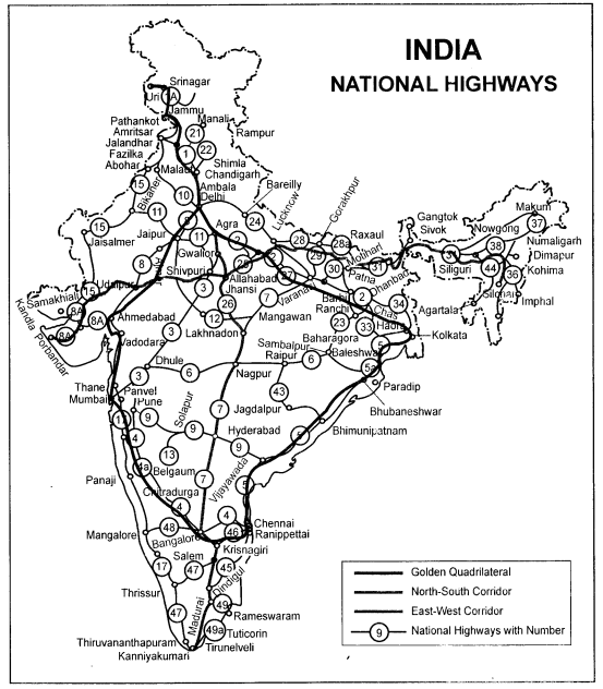
Question 1.
On the map of India show the following :
(1) Golden Quadrilateral
(2) North-South corridor
(3) East-West corridor
(4) National Highways with number.
Answer:
- Golden Quadrilateral will connect Delhi, Mumbai, Chennai, Kolkata and Delhi. Its length will be 5,846 km.
- North-South corridor : It will connect Srinagar and Kanniyakumari.
- East-West corridor will connect Silchar and Porbandar.
- National Highways connect one state with another. They are of national importance. These roads are maintained by the Central Government.
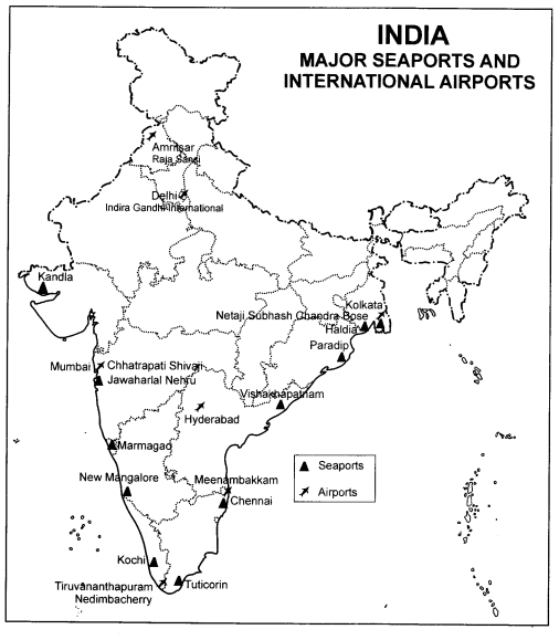
Question 2.
On the outline map of India show the following :
- Sea ports
- International Airports.
Answer:
Major sea ports and airports are as given below :
- Sea ports: Kandla, Mumbai, Marmagao, New Mangalore, Kochchi, Tuticorin, Paradip, Vishakhapatnam, Chennai and Haldia.
- International Airports: Amritsar (Raja Sansi), Delhi, Mumbai, Hyderabad, Chennai, Thiruvananthapuram, Kolkata. See map given below :
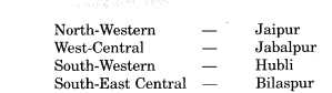
Question 3.
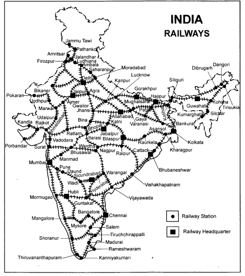
On the map of India locate headquarters of the railway zones in India.
Answer:
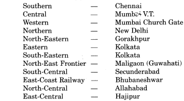
The headquarters of the sixteen zones are as given below :
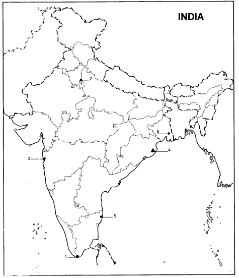
Question 4.
Six features with serial numbers (1) to (6) are marked in the given political outline map of India. Identify these features with the help of the following information and write their correct names on the lines marked in the map.
(1) Southern point of North-South corridor.
(2) A point in Golden Quadrilateral.
(3) An International Airport.
(4) A major sea port.
(5) Headquarter of Eastern Railways.
Answer:
- Kaniyakumari
- Delhi
- Mumbai
- Paradip
- chinnai
- Kolkata
We hope the Extra Questions for Class 10 Social Science Geography Chapter 7 Lifelines of National Economy help you. If you have any query regarding Extra Questions for Class 10 Social Science Geography Chapter 7 Lifelines of National Economy, drop a comment below and we will get back to you at the earliest.