NCERT Class 9 Geography Chapter 4 Notes Climate

NCERT Class 9 Geography Chapter 4 Notes

On this page, you will find NCERT Class 9 Geography Chapter 4 Notes Pdf free download. CBSE Class 9 Social Science Notes Geography Chapter 4 SST Climate will seemingly, help them to revise the important concepts in less time.

Climate Class 9 Notes Social Science Geography Chapter 4

CBSE Class 9 Geography Chapter 4 Notes Understanding the Lesson

1. Climate refers to the sum total of weather conditions and variations over a large area for a long period of time.

2. Weather refers to the state of the atmosphere over an area at any point of time.

3. The elements of weather and climate are the same i.e., temperature, atmospheric pressure, wind, humidity and precipitation.

4. The climate of India is described as the monsoon type. Temperature and precipitation vary from place to place and season to season.

5. In upper parts of Himalayas precipitation is mostly in the form of snowfall but in the rest of the country it rains. Most parts of the country receives rainfall from June to September. There is decrease in rainfall generally from east to west in the Northern Plains.

6. There are six major controls of the climate of any place-latitude, altitude, pressure and wind system, distance from the sea, ocean currents and relief features.

7. India’s climate has characteristics of tropical as well as sub-tropical climates. The Himalayas in the north of India prevent the cold winds from Central Asia from entering the sub-continent.

8. The climate and associated weather conditions in India are governed by-pressure and surface winds, upper air circulation; and western cyclonic disturbances and tropical cyclones.

9. The pressure and wind conditions over India are unique. During winter, there is a high-pressure area north of the Himalayas. In summer, a low-pressure area develops over interior Asia as well as over northwestern India.

10. The climate of India is strongly influenced by monsoon winds. The monsoons are experienced in the tropical area roughly between 20°N and 20°S.

11. The duration of monsoon in India is between 100-120 days from early June to mid-September. It arrives at the southern tip of the Indian peninsula by the first week of June. Subsequently, it proceeds into two-the Arabian sea branch and the Bay of Bengal branch.

12. The Arabian sea branch reaches Mumbai by the 10th of June and the Bay of Bengal branch arrives in Assam in the first week of June. Both these branches merge over the northwestern part of the Ganga plains.

13. The retreat of the monsoon begins in northwestern states of India by early September. By mid- October, it withdraws completely from the northern half of the peninsula. By early December, the monsoon has withdrawn from the rest of the country.

14. Four seasons can be identified in India-the cold-weather season, the hot weather season, the advancing monsoon and the retreating monsoon with some regional variations.

15. The cold-weather season begins from mid-November in northern India and stays till February. The hot-weather season remains from March to May. The rainy season starts from early June. By the beginning of October, the monsoon withdraws from the Northern plains.

16. December and January are the coldest in the northern part of India. The summer months experience rising temperature and falling air pressure in this part.

17. ‘Loo’ is a striking feature of the hot weather season. It blows over the north and northwestern India.

18. The retreat of monsoon is marked by clear skies and rise in temperature. While day temperature are high, nights are cool and pleasant.

19. Distribution of rainfall varies from place to place. It is highest in parts of western coast and northeastern India and lowest in western Rajasthan and adjoining parts of Gujarat, Haryana and Punjab.

20. Areas of high rainfall are liable to be affected by floods and areas of low rainfall are drought-prone.

21. The uncertainties of rain and uneven distribution are very much typical of the monsoons. The Indian landscape, its animal and plant life, its entire agriculture calender and the life of the people, revolve around this phenomenon.

Climate Class 9 CBSE Notes Important Terms

Weather: The state of atmosphere over an area of at any point of time.

Climate: The sum total of weather conditions and variation over a large area for a long period of time.

Monsoon: The seasonal prevailing wind in the region of South and South East Asia, blowing from the south-west between May and September and bringing rain.

Precipitation: Rain, snow, sleet or hail that falls to or condenses on the ground.

Loo: Strong, gusty, hot, dry winds blowing during the day over the north and north-western India.

Mahawat: The local name for the total amount of winter rainfall.

Relief: The highest and lowest elevation points in an area.

NCERT Class 9 Geography Chapter 3 Notes Drainage

NCERT Class 9 Geography Chapter 3 Notes

On this page, you will find NCERT Class 9 Geography Chapter 3 Notes Pdf free download. CBSE Class 9 Social Science Notes Geography Chapter 3 SST Drainage will seemingly, help them to revise the important concepts in less time.

Drainage Class 9 Notes Social Science Geography Chapter 3

CBSE Class 9 Geography Chapter 3 Notes Understanding the Lesson

1. The term ‘Drainage’ describes the river system of an area. The area drained by a single river system is called a drainage basin.

2. Any mountain or an upland separating two drainage basins is called a water divide.

3. The Indian rivers are divided into two major groups

  • the Himalayan rivers and
  • The peninsular rivers.

4. Some of the features of the Himalayan rivers are-they are perennial, they have long courses from heir source to the sea, they perform intensive erosional activity in their upper courses and carry huge loads of silt and sand.

5. Some of the features of the Peninsular rivers are-they are seasonal, they have shorter and shallower courses as compared to the Himalayan rivers, most of them originate in the Western Ghats and flow towards the Bay of Bengal.

6. The streams within a drainage basin form certain patterns, depending on the slope of land, underlying rock structure as well as the climatic conditions of the area.

7. Types of drainage patterns are-dendrite, trellis, rectangular and radial patterns.

8. The major Himalayan rivers are-the Indus, the Ganga and the Brahmaputra. The river Indus rises in Tibet, near Lake Mansarovar. It flows through Baltistan and Gilgit and emerges from the mountains at Attock. The Indus plain has a very gentle slope. The Indus is one of the longest rivers of the world.

9. The Ganga emerges from the mountains on to the plains at Haridwar. The river is joined by tributaries such as the Yamuna, the Ghaghara, the Gandak and the Kosi. The length of the Ganga is over 2500 km.

10. The Brahmaputra is slightly longer than the Indus and most of its course lies outside India. The river rises in Tibet east of Mansarovar lake. It flows eastwards parallel to the Himalayas. Every year during the rainy season, the river overflows its banks, causing widespread devastation due to floods in Assam and Bangladesh.

11. Major rivers of the Peninsula such as the Mahanadi, the Godavari, the Krishna and the Kaveri flow eastwards and drain into the Bay of Bengal. These rivers make deltas at their mouths. The Narmada and the Tapi flow west and make estuaries.

12. The Narmada rises in the Amarkantak hills in the Madhya Pradesh. On its way to the sea, it creates many picturesque sites. The Narmada basin covers parts of Madhya Pradesh and Gujarat.

13. The Tapi rises in the Satpura ranges, in the Betul district of Madhya Pradesh. Its basin covers parts of Madhya Pradesh, Gujarat and Maharashtra.

14. The Godavari, the largest Peninsular river, rises in the Nasik district of Maharashtra. Its basin covers parts of Maharashtra, Madhya Pradesh, Odisha and Andhra Pradesh.

15. The Mahanadi rises in the highlands of Chhattisgarh. Its drainage basin is shared by Maharashtra, Chhattisgarh, Jharkhand and Odisha.

16. The Krishna rises from a spring near Mahabaleshwar. It drains into the Bay of Bengal. Its drainage basin is shared by Maharashtra, Karnataka and Andhra Pradesh.

17. The Kaveri rises in the Brahmagri range of the Western Ghats and it reaches the Bay of Bengal in south of Cuddalore, in Tamil Nadu. Its basin drains parts of Karnataka, Kerala and Tamil Nadu.

18. India has many lakes which differ from each other in size, and other characteristics. Most lakes are permanent while some contain water only during the rainy season.

19. Some of the lakes have come into existence as the result of the action of glaciers and ice sheets while the others have been formed by wind, river action and human activities.

20. Most of the fresh-water lakes are in the Himalayan region. The Wular lake in Jammu and Kashmir is the largest freshwater lake in India. Some lakes such as Guru Gobind Sagar have been artificially created by damming of rivers for power generation.

21. Rivers play an important role in country’s economy. Their water is used for irrigation, navigation, hydro-power generation, etc.

22. Excess use of river water has affected its quality. Untreated sewage and industrial effluents are emptied into the rivers as a result of which their self-cleansing capacity is lost.

23. Increasing urbanization and industrialization are also major reasons of river pollution. It is high time to think over it and do accordingly.

Drainage Class 9 CBSE Notes Important Terms

Drainage: The river system of an area.

Drainage basin: The area drained by a single river system.

Water divide: Any mountain or an upland that separates two drainage basins is called a water divide.

Perennial rivers: Rivers having water throughout the year.

River system: A river along with its tributaries.

Seasonal rivers: Rivers having water only during rainy season.

Floodplain: An area of low-lying ground adjacent to a river, formed mainly of river sediments and subject to flooding.

River delta: A landform that forms from deposition of sediment carried by a river as the flow leaves its mouth and enters slower-moving or standing water.

Gorges: Deep, narrow valleys with a stream or river running along their bottom.

Bhagirathi: The headwaters of the Ganga.

Tributary: A river or stream flowing into a larger river or lake.

Glacier: A slowly moving mass or river of ice formed by the accumulation and compaction of snow on mountains or near the poles.

Distributary: A branch of a river that does not return to the mainstream after leaving it as in a delta.

Meander: A winding curve or bend in a river.

Rift valley: A linear-shaped lowland between several highlands or mountain ranges created by the action of a geologic rift or fault.

Lake: A large area of water surrounded by land.

Sea: A lake of large extent.

Trough: A narrow depression as in the earth or between ocean waves or in the ocean bed. A narrow channel, gutter or gulley.

NCERT Class 9 Geography Chapter 1 Notes India Size and Location

NCERT Class 9 Geography Chapter 1 Notes

On this page, you will find NCERT Class 9 Geography Chapter 1 Notes Pdf free download. CBSE Class 9 Social Science Notes Geography Chapter 1 SST India Size and Location will seemingly, help them to revise the important concepts in less time. India Size and Location

India Size and Location Class 9 Notes Social Science Geography Chapter 1

CBSE Class 9 Geography Chapter 1 Notes Understanding the Lesson

1. India lies entirely in the Northern Hemisphere. The mainland extends between latitudes 8°4′ N and 37°6′ N and longitudes 68°7′ E and 97°25′ E. The Tropic of Cancer divides the country in two halves. The landmass of India has an area of 3.28 million square km. India’s total area accounts for about 2.4 percent of the total geographical area of the world.

2.India has a land boundary of about 15,200 km and the total length of the coastline of the mainland including Andaman and Nicobar and Lakshadweep is 7,516.65 km.

3. The Indian landmass has a central location between the East and West Asia. India is a southward extension of the Asian continent.

4. India occupies an important strategic position in South Asia. India has 29 states and 7 Union Territories. The neighbouring countries of India are-Pakistan, Afghanistan, China, Nepal, Bhutan, Myanmar, Bangladesh, Sri Lanka and Maldives.

5. India has had strong geographical and historical links with her neighbours.

India Size and Location Class 9 CBSE Notes Important Terms

Longitude: It refers to the imaginary lines that bisect the globe through the North and South Poles the ones that run vertically, as opposed to the lines of latitude that run horizontally, parallel to the equator.

Latitude: The angular distance east or west on the earth’s surface, measured by the angle contained between the meridian of a particular place and some prime meridian, as that of Greenwich, England, and usually expressed in degrees.

Equator: The imaginary great circle around the earth’s surface equidistant from the poles and perpendicular to the earth’s axis of rotation. It divides the earth into the Northern Hemisphere and the Southern Hemisphere.

Mainland: A large continuous extent of land that includes the greater part of a country or territory, as opposed to offshore islands and detached territories.

Coastline: The land along a coast. A line that forms the boundary between the land and the ocean, or a lake.

Pass: A gap or break in high, rugged terrain such as a mountain ridge.

Merchandise: Goods to be bought and sold.

NCERT Class 9 Geography Chapter 2 Notes Physical Features of India

NCERT Class 9 Geography Chapter 2 Notes

On this page, you will find NCERT Class 9 Geography Chapter 2 Notes Pdf free download. CBSE Class 9 Social Science Notes Geography Chapter 2 SST Physical Features of India will seemingly, help them to revise the important concepts in less time.

Physical Features of India Class 9 Notes Social Science Geography Chapter 2

CBSE Class 9 Geography Chapter 2 Notes Understanding the Lesson

1. The land of India displays great physical variation. Different geological periods have influenced her relief. Besides geographical formations, a number of processes such as weathering, erosion and disposition have created and modified the relief to its present form.

2. According to the theory of Plate tectonics, the upper part of the earth has been formed out of seven major and some minor plates. The movement of these plates are classified into three types- convergent boundary, divergent boundary and transform boundary.

3. The oldest landmass was a part of the Gondwana land. The Gondwana land included India, Australia, South Africa, South America and Antarctica as one single landmass.

4. Geologically, the Peninsular Plateau constitutes one of the ancient landmasses on the earth’s surface. The Himalayas and the Northern Plains are the most recent landforms.

5. The physical features of India can be grouped under six physiographic divisions-the Himalayan Mountains, the Northern Plains, the Peninsular Plateau, the Indian Desert, the Coasted Plains and the Islands.

6. The whole mountain system of Himalayas represents a very youthful topography with high peaks, deep valleys and fast-flowing rivers. The Himalayas consist of three parallel ranges in its longitudinal extent-The Great or Inner Himalayas or the Himadri, Himachal or lesser Himalayas and the Shivaliks.

7. Besides the longitudinal divisions, the Himalayas have been divided on the basis of regions from west to east-Punjab Himalayas, Kumaon Himalayas, the Nepal Himalayas and Assam Himalayas.

8. The Brahmaputra marks the easternmost boundary of the Himalayas known as the Purvachal or the eastern hills and mountains. The Purvachal comprises the Patkai hills and Naga hills, Manipur hills and the Mizo hills.

9. The Northern Plains are formed of alluvial deposits. The three major river systems of which the plain have been formed are-the Indus, the Ganga, and the Brahmaputra along with their tributaries.

10. The Northern plains are broadly divided into three sections-The Punjab plains, the Ganga plain and the Brahmaputra plain. These plains have diverse relief features. According to the variations in relief features, they can be divided into four regions.

11. The largest part of the Northern Plains is formed of older alluvium. They lie above the floodplains of the rivers and is known as The newer, younger deposits of the flood plains are called khadar.

12. The Peninsular plateau is composed of igneous and metamorphic rocks with gently rising hills and wide valleys. This plateau consists of two broad divisions, namely, the Central Highlands and the Deccan Plateau. The Deccan Plateau is a triangular landmass that lies to the south of the river Narmada.

13. The Western Ghats and the Eastern Ghats mark the western and the eastern edges of the Deccan plateau respectively. The Western Ghats are continuous and are higher than the Eastern Ghats.

14. The Great Indian desert lies towards the western margins of the Aravali Hills. It is an undulating sandy plain covered with sand dunes. This region receives very low rainfall.

15. The coastal plains of India are located along the Arabian Sea coast in the west and along the Bay of Bengal coast in the east. According to their location to the east or west of the peninsular plateau, they are a called-East coastal plain and West coastal plain.

16. India has two groups of Islands-The Lakshadweep Islands groups and the Andaman and Nicobar Islands. The Lakshadweep Islands groups lie close to the Malabar coast of Kerala and the Andaman and Nicobar Islands are located in the Bay of Bengal.

17. Different physiographic units highlights the unique features of each region. Each region complements the other and makes the country richer in its natural resources.

Physical Features of India Class 9 CBSE Notes Important Terms

Folding: A type of earth movement resulting from the horizontal compression of rock layers by internal forces of the earth along plate boundaries.

Faulting: A crack in the earth’s crust resulting from the displacement of one side with respect to the other.

Gondwana land: It is the southern part of the ancient supercontinent Pangea with Angara land in the northern part.

Tethys: The sedimentary rocks accumulated in the geosyncline.

Duns: The longitudinal valley lying between lesser Himalaya and the Shivaliks.

Alluvium: A deposit of clay, silt and sand left by flowing floodwater in a river valley or delta, typically producing fertile soil.

Doab: The term is made up of two words-‘do’ meaning two and ‘ab’ meaning water.

Distributaries: Branches of rivers that do not return to the mainstream after leaving it.

Terai: A wet, swampy and marshy region.

Kankar: The soil containing calcareous deposits.

Khadar: The newer, younger alluvium of the flood plains.

Bhangar: The older alluvium lying above the flood plains of the rivers and presenting a terrace like feature.

Central Highlands: The part of the Peninsular plateau lying to the north of the Narmada river covering a major area of the Malwa plateau.

Western Ghats: The western edges of the Deccan plateau.

Eastern Ghats: The eastern edges of the Deccan plateau.

Deccan Trap: The black soil area of the Peninsular plateau.

Barchans: Crescent-shaped dunes found in the desert regions.

Dune: A hill of loose sand built by wind or the flow of water.

Konkan: The northern part of the coast.

Kannad plain: The central stretch of level open land.

Coral polyps: Short-lived microscopic organisms, which live in colonies.

Management of Natural Resources Class 10 Notes Science Chapter 16

Management of Natural Resources Class 10 NotesOn this page, you will find Management of Natural Resources Class 10 Notes Science Chapter 16 Pdf free download. CBSE NCERT Class 10 Science Notes Chapter 16 Carbon and its Compounds will seemingly help them to revise the important concepts in less time.

CBSE Class 10 Science Chapter 16 Notes Management of Natural Resources

Management of Natural Resources Class 10 Notes Understanding the Lesson

1. Natural resources: The resources provided by the nature and utilised by human beings are called natural resources. Example: Soil, air, water, forests, wildlife, coal, petroleum, etc. Management of Natural Resources is necessary for their conservation and sustainable development.

2. Efforts for Environment Protection: There are international laws and regulations; National laws and acts creating awareness and National and international organisations working towards protecting our environment.

3. Ganga Action Plan: A multi-crore project came about in 1985 to improve quality of the water in the Ganga.

4. Coliform: A group of bacteria found in human intestines. Its presence in water indicates contamination by disease-causing microorganisms.

5. Survey for Coliform Count in 1993-1994: The results of survey done in 1993-1994 for finding total coliform in terms of MPN/100 mL is:
Minimum desired level 450 MPN/100 mL; Minimum level found in Rishikesh 600-650 MPN/100 mL; Maximum level found in Kannauj 1400 MPN/100 mL.

6. Pollution of the Ganga: The Ganga runs a course of 2500 km from Gangotri in the Himalayas to Ganga Sagar in the Bay of Bengal. It is getting polluted due to the flow of garbage, excreta, untreated sewage which are dumped into it. Also, human activities like bathing, washing of clothes and immersion of ashes or unbumt corpses, chemical effluents from industries increase its pollution load. This leads to toxicity which kills fish in large sections of the river.

7. The three R’s to save the environment: Reduce, Recycle and Reuse.

8. Reduce: Use less and not to waste any resource.

9. Recycle: Segregate the waste that can be recycled and make required things by using them,

10. Reuse: Use the things again and again.

11. Reuse is better than recycling: Reusing helps to save energy, so it is better than recycling.

12. Concept of sustainable development: Encourage forms of growth and development which helps to meet current basic human needs while preserving the resources for the needs of future generations. In this way economic development is linked to environmental conservation.

13. Need to Manage Natural Resources: The human population is increasing at a tremendous rate due to improvement in health care, so the demand for all resources is increasing at an exponential rate. Since the resources are limited, the management of natural resources is necessary, so that these will last for the generations to come. This management would help in equitable distribution of resources and reducing the damage being done to the environment.

14. Biodiversity Hot Spots: Forests are biodiversity hot spots. Number of species found in an area is one of the measures of biodiversity along with the range of different life forms (bacteria, fungi, ferns, flowering plants, nematodes, insects, birds, reptiles, etc.)

15. Result of loss in biodiversity: Experiments and field studies suggest that a loss of diversity may lead to a loss of ecological stability.

16. Stakeholder: A person having interest or concern for something is called as stakeholder. The various stakeholders for the conservation of forests are:

  • Local People: Those who are dependent on forests for their survival.
  • Forest Department: Government who owns the land and controls resources
  • Industrialists: Those who use various forests
  • Wildlife enthusiasts: Those who want to conserve nature

17. Efforts of Bishnoi community in Rajasthan: Bishnoi community of Rajasthan has religiously being protecting the environment. ‘Amrita Devi Bishnoi National Award for Wildlife Conservation’ is given by the Government in the memory of Amrita Devi Bishnoi, who in 1731 AD sacrificed her life along with 363 others for the protection of‘khejri’ trees in Khejarli village near Jodhpur in Rajasthan.

18. Sustainable Management: The management of forest resources wisely and judiciously to fulfil needs of present generation as well as future generations.

19. The Chipko Andolan (‘Hug the Trees Movement’): This movement for conservation of forests originated in a remote village called Reni in Garhwal Himalayas during the early 1970s when the women of the village clasped the tree trunks thus preventing the workers of logging contractor from felling the trees.

20. People’s Participation in the Management of Forests: In 1972, the West Bengal Forest Department failed in reviving the degraded Sal forests in the south-western districts of the state by methods of surveillance and policing. Complete alienation of the people from the administration led to movements by the Naxalites and into frequent clashes between forest officials.

21. Due to efforts of forest officer A.K. Baneijee, villagers were involved in the protection of 1,272 hectares of badly degraded Sal forest. Villagers were given employment in both silviculture and harvesting operations, 25 per cent of the final harvest, and allowed fuel wood and fodder collection on payment of a nominal fee in return of such help in protection. By 1983, the previously worthless Sal forests in Arabari forest range of Midnapore district underwent a remarkable recovery and were valued ? 12.5 crores with the active and willing participation of the local community.

22. Water as a Resource
Reasons for failure to sustain water availability underground:
Loss of vegetation cover, diversion for high water demanding crops, and pollution from industrial effluents and urban wastes.

23. Dams
Advantages of Dams:

  • Ensure the storage of adequate water for irrigation and generating electricity.
  • Canal systems leading from these dams can transfer large amounts of water great distances. Disadvantages of Dams:
  • No equitable distribution of water.
  • Large number of people displaced without compensation.
  • Huge amount of public money is involved without giving proper benefits.
  • Loss of biological diversity and deforestation.

24. Criticisms about large dams: They lead to

  • Social problems: They displace large number of peasants and tribals without adequate compensation or rehabilitation.
  • Economic problems: They swallow up huge amounts of public money without the generation of proportionate benefits.
  • Environmental problems: They contribute enormously to deforestation and the loss of biological diversity.

25. Narmada Bachao Andolan (‘Save the Narmada Movement’): The movement started against the raising of the height of the Sardar Sarovar Dam on the river Narmada.

26. Water Harvesting: Watershed management emphasises scientific soil and water conservation in order to increase the biomass production.

27. Aim: To develop primary resources of land and water to produce secondary resources of plants and animals for use in a manner that will not cause ecological imbalance.

28. Benefits of Watershed management:

  • Increases the production and income of the watershed community
  • Mitigates droughts and floods
  • Increases the life of the downstream dam and reservoirs.

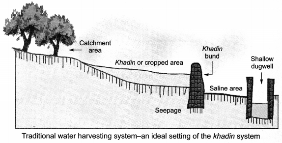
29. Various ancient methods of water harvesting:

  • Khadins, tanks and nadis in Rajasthan
  • Bundhis in Madhya Pradesh and Uttar Pradesh
  • Kulhs in Himachal Pradesh
  • Eris (tanks) in Tamilnadu
  • Kattas in Karnataka
  • Bandharas and tals in Maharashtra
  • Ahars and pynes in Bihar
  • Ponds in the Kandi belt of Jammu region
  • Surangams in Kerala,

Management of Natural Resources Class 10 Notes Chapter 16 1

30. Purpose of Water Harvesting:

  • To recharge the ground water beneath.

31. Advantages of water stored in the ground:

  • It does not evaporate.
  • Spreads out to recharge wells and provides moisture for vegetation over a wide area.
  • Does not provide breeding grounds for mosquitoes like stagnant water.
  • It is relatively protected from contamination by human and animal waste.

32. Coal and Petroleum

  • They are generally called fossil fuels.
  • They are formed from the degradation of biomass millions of years ago.
  • They will be exhausted in the future no matter how carefully we use them.
  • Petroleum resources will last for about forty years while coal resources will last for two hundred years.
  • They contain carbon, hydrogen, nitrogen and sulphur.
  • They produce carbon dioxide, water, oxides of nitrogen and oxides of sulphur on being burnt.
  • Carbon monoxide is formed instead of carbon dioxide, when they are burnt in insufficient amount of oxygen.
  • The oxides of sulphur and nitrogen and carbon monoxide are poisonous at high concentrations and carbon dioxide is a greenhouse gas.
  • Increase in amount of carbon dioxide is leading to global warming.

33. Ways to use resources judiciously:

  • Taking a bus, public transport or walking/cycling instead of a private vehicle.
  • Using LED bulbs in homes instead of normal bulbs.
  • Taking the stairs instead of lift.
  • Wearing an extra sweater on cold days instead of burning fossil fuels for warmth.

Class 10 Science Chapter 16 Notes Important Terms

Natural Resources: The stocks of nature such as air, water, soil, forests and wildlife. Biodiversity: The diversity of life forms present on Earth.

Sustainable Management: The judicious and wise use of natural resources to fulfil needs of present generation and preserving them for needs of the future generations.

Coliform: Group of gram negative, rod shaped bacteria found in polluted water and in human intestine. Coliform Count: Measure of pollution level of a water body on the basis of presence of coliform bacteria.

Silviculture: Practice of growing trees. Helpful in replenishment of forests.

Monoculture: A culture of single type of plant or tree in an area of forest.

Deforestation: Cutting down trees.

Afforestation: Growing or planting trees.

Reforestation: Growing or planting trees in a deforested area which previously had trees and vegetation.