Here we are providing Class 12 Geography Important Extra Questions and Answers Chapter 5 Field Surveys. Geography Class 12 Important Questions are the best resource for students which helps in class 12 board exams.
Class 12 Geography Chapter 5 Important Extra Questions Field Surveys
Field Surveys Important Extra Questions Short Answer Type
Question 1.
What do you understand by the term ‘Field Work’ ? Explain its necessity, importance and aim.
Answer:
Geography is a field oriented science. It is an areal science which studies the differences in natural, social, cultural and economic characteristics between different regions. This study is done with the help of maps. But a detailed and practical knowledge of an area can be obtained only by conducting a field-work and visiting the area. Field work provides permanent information. According to Prof. Fairgrieve, “Geography comes through the soles of one’s shoes.”
According to Prof. E.A. Freeman, “Geography is a matter of travel, a matter of seeing things with our own eyes.”
Field Work. Field work involves observing the area personally to collect and compile data regarding socio-economic conditions of the area. It is done by enquiring the people with the help of a specially prepared questionnaire.
Necessity. The published data of an area is sometimes not sufficient for geographical study. Therefore, the study of the different aspects of socioeconomic conditions can be done with the help of field work by which we can collect first hand information and data and analyse them by various methods. Therefore field work is necessary to understand the relation between man and his environment in an area.
Field work has two basic steps :
- Collection of data
- Processing of data.
Satellite images are important source of study in Geography, but field work is the important source of latest information.
Importance and objectives.
- Field work helps to study the relation between physical and cultural aspects of the environment.
- It helps to get the first hand information about the local Geography of an area.
- It develops the qualities of team spirit and leadership among the students.
- It provides an opportunity to interview the people about socio-economic conditions.
- With the help of field work, a geographer can himself collect data and prepare the maps.
- It provides a practical knowledge of an area.
- Field work makes the geographical study of an area easy and interesting.
Question 2.
Describe the different stages involved in Field work.
Answer:
Field work involves different stages of work. It includes observation of the area; collection and compilation of data, representing it on maps with the help of cartographic techniques. This work is done systematically in different stages. Field work is divided into the following stages:
1. Preliminary Stage. In this stage, it is planned to conduct the field work.
- The area is selected.
- The topic is selected
- A base map of the area is prepared
- Many copies of the outline map are prepared
- A topographical map of the area is obtained.
2. Operational Stages.
- The area is personally visited by the surveyor.
- A questionnaire related to the topic is prepared.
- Latest data is collected.
- A sample survey is done where the number is large.
- Detailed information of the area is obtained from the topographical map.
3. Tabulation Stage. The collected data is arranged in a tabular form. The average data is calculated to get the minimum number of data.
4. Mapping Stage. The data is shown by statistical diagrams. Cartographic techniques are used to prepare maps to obtain certain patterns and results.
5. Reporting Stage. At the end of the survey, a report is prepared. It includes a detailed description of the area. Some results are obtained on the basis of this survey. Some suggestions are made to meet the aims of the survey.
Question 3.
How is a questionnaire prepared ?
Answer:
A specially prepared questionnaire is used to collect data. People are interviewed with the help of this questionnaire. This questionnaire forms the basis of field work. The following techniques should be followed while preparing a questionnaire:
(i) A questionnaire should be prepared after visiting the area personally.
(ii) The main aim of the survey should always be kept in mind.
(iii) The questions should be short and direct.
(iv) The questions should be simple so that these can be answered easily.
(v) Questions should be related to field work.
(vi) Questions that may hurt the personal or religious feelings of the people should not be asked.
Precautions:
(i) The surveyor should establish good relations with the people to be interviewed.
(ii) Answers should be brief.
(iii) Every entry of the questionnaire should be filled immediately.
(iv) The surveyor should not impose his personal views.
(v) The surveyor should fix the time for interview with the respondent at their convenience.
Question 4.
What do you mean by Questionnaire ? Describe its types.
Answer:
Questionnaire : Questionnaire method involves putting previously framed questions to the selected persons. The questionnaire can be structured or unstructured. When a structured questionnaire is administered, there is no scope for manoeuvring on the part of the researcher. He has to mechanically put the questions and note down the answers. In un-structured questionnaires, the order in which questions are put can be changed according to the need of the surveyor. A map or sketch can be drawn while recording the answer. As a guide each question includes, in brackets, some remarks on how one should process the answers.
Type of Questionnaire. There are several types of questions. Which type should be administered depends on the nature of data required and the background of the people to whom the questionnaire is administered.
The different types of questions include :
(а) Simple choice questions
(b) Multiple choice questions
(c) Semantic scale questions
(d) Open ended questions.
(a) Simple Choice Questions
Simple choice questions can be answered in a Yes or No. For example, the response to the question: Do you practise agriculture? would be simple Yes or No. These questions are useful for collecting information related to occupation of the people.
(b) Multiple Choice Questions
In case of multiple choice questions, some answers are given, but only one of the answers is correct. Example : Why is the sugar factory in region ‘X’ located at place ‘A’ ? The probable answers are :
- Availability of land
- Availability of labour
- Availability of capital
- Access to the market.
- Personal preference for residence of owner/ entrepreneur.
- Any other reason.
Only one of the above answers mentioned is correct. But the answer will give an idea about the consideration that has been instrumental behind setting up of a factory.
3. Semantic Scale Questions
The degree of feeling of the respondent is noted down on a point scale. How strongly the respondent feels in favour or against the issue is to be noted down.
For example: How do you rate the anti-poverty programmes implemented by the government?
- Very good
- Good
- Satisfactory
- Bad
- Very bad.
The rating answer of the respondent is noted down. This kind of information will give an idea about the public opinion regarding a policy or a programme.
4. Open Ended Questions
In this case, questions are administered and the answers as given by the respondents are recorded.
For example: What steps should the government undertake to eradicate poverty?
The answers will vary from person to person depending upon his personal, social and economic background.
Question 5.
How will you conduct the land use survey of a village ? Prepare a questionnaire to be used.
Answer:
Land Use Survey
1. Introduction. India is an agricultural country. So field work for land use studies is necessary for the development of agriculture in India. This survey is done by taking a village as a unit. It shows the main conditions, type of agriculture and different patterns of uses of land in an area.
2. Aims
(i) To know the land use of a cultivated area.
(ii) To show the types of land use on maps.
(iii) To know the crops grown.
(iv) To find out the different types of soils.
(v) To determine the irrigated area.
3. Method. A village, as a unit, is selected for this type of survey. A cadastral map of the village is obtained from the Patwari of the village. This map shows the numbers and boundaries of the fields. Some copies of this outline map are prepared. On this map, the location of the village is clearly marked.
The following information is obtained from the record of the Patwari of the village:
- Total geographical area of the village.
- Land not available for cultivation.
- Other uncultivated area.
- Net area sown.
- Net area irrigated.
- No. of fields.
- The average size of fields.
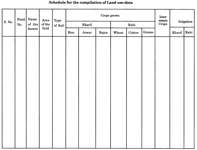
The data and time for interview with the farmer is fixed. A proper questionnaire is prepared to collect the required information. The fields are classified into different groups; each farmer is contacted personally.
Field Work. Every field is visited by the surveyor. The farmers who cultivate these fields are interviewed. The information regarding the general character of the field, the size of the farms, the types of crops, etc., is obtained from the farmers. This information is written in the questionnaire.
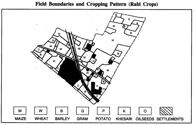
Rabi and Kharif crops are shown with the help of symbols or letters. The soils and land use is shown by colour or shading method. Different types of data is tabulated. Different maps are prepared using cartographic techniques.
4. Report. The maps and data are analysed to present a final report. The interpretation of maps helps to obtain certain conclusion, such as:
- Pattern of land use
- Types of soils
- Net sown area
- Intensity of cultivation.
- Types of irrigation.
- Steps to improve the land use.
Question 6.
Describe the field-study of soil degradation, environmental pollution in Industrial areas and Urban areas.
Ans.
Environmental Pollution. Environmental pollution includes soil pollution, water pollution, air pollution and noise pollution.
1. Field study of Soil Pollution
(i) Causes of pollution and solid waste contamination can be ascertained through interaction with the residents of the area.
(ii) The polluting unit and its effect on the surroundings, the hardships of people and deterioration of soil in the adjoining area can be found out by talking to the people.
(iii) The field surveyors have to look at the solid waste management techniques used, the role of various stakeholders, the initiatives taken to solve the problem and progress made so far.
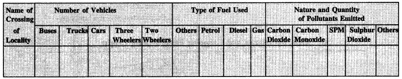
2. In Industrial areas. In Industrial areas fossil fuels cause environmental pollution. The effect on the health of local people can be found. The polluted areas have to be demarcated.
Questionnaire for Study of Pollution of Industrial areas
| Sr.No. | Name and Address of the factory | Name of the products | Nature of Fuel used | Quantity of Fuel used | Nature of Pollutants | Effect on The Environment | |||
| Smoke | Gases | Liquids | Solids | ||||||
| 1. | |||||||||
| 2. | |||||||||
| 3. | |||||||||
| 4. | |||||||||
| 5. | |||||||||
3. Pollution by Transport. Various vehicles such as Buses, Cars, Trucks, Two-wheelers, etc., and the major source of pollution in urban areas.
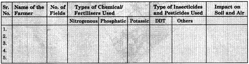
4. Pollution in Agricultural areas. A large number of chemicals, pesticides are used in agriculture to increase the yield and protect the crops.
Question 7.
Describe the method and aims of field study of Poverty in a region.
Answer:
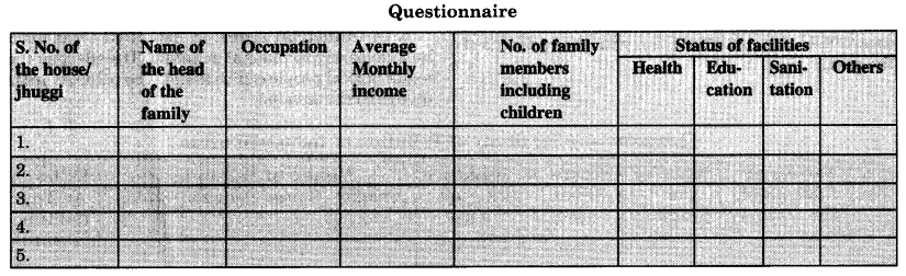
Field-Study of Poverty. Unemployment and lack of education are the main causes of poverty. A socio-economic study of poverty in a given area can be undertaken. It can be a study of each household in slum areas.
Measure of Poverty.
- Information on average income
- calorie intake
- medical facilities available
- occupation
- The distribution of population
- human habitations
- food, clothing along with the social and cultural relations in the area between various income groups can be found out by carefully worded questionnaire.
Aims.
- The initiative of the government, various poverty alleviation schedules, their impact on people in the area can also be ascertained by effective questionnaire.
- To infer the poverty situation in an area.
- To know the causes of poverty.