CBSE Class 9 Geography Chapter 1 Extra Questions India-Size and Location Pdf free download are part of Extra Questions for Class 9 Social Science. Here we have given NCERT Extra Questions for Class 9 Social Science SST Geography Chapter 1 India-Size and Location.
You can also practice NCERT Solutions for Class 9 Geography Chapter 1 Questions and Answers on LearnInsta.com.
Extra Questions for Class 9 Social Science Geography Chapter 1 India-Size and Location
Very Short Answer Type Questions
Question 1.
In which hemisphere does India lie?
Answer:
India lies in the Northern hemisphere.
Question 2.
What is the latitudinal extent of India?
Or
What are the degrees of the southernmost latitude of mainland India? [CBSE 2011]
Or
What are the degrees of the northernmost latitude of India?
Answer:
The latitudinal extent of India is between 8°4′ N (southernmost) and 37°6’ N and (northernmost) latitude.
Question 3.
What is the longitudinal extent of India?
Or
What are the degrees of the easternmost and westernmost longitude of India?
Answer:
The longitudinal extent of India is 68°7′ E (westernmost) to 97°25′ E (easternmost) longitude.
You can also Download NCERT Solutions for Class 9 Social Science PDF to help you to revise complete Syllabus and score more marks in your examinations.
Question 4.
Name the parallel of latitude which divides India roughly into two equal halves.
Answer:
The parallel of latitude which roughly divide India into two equal halves is the Tropic of Cancer (23° 30′ N).
Question 5.
Name the two seas located around India.
Answer:
The two seas located around India are the Arabian Sea in the west and the Bay of Bengal in the east.
Question 6.
What is the southernmost point of the Union of India?
Answer:
Southernmost point of the Union of India is Indira Point.
Question 7.
In which year did ‘Indira Point’ submerge under water due to tsunami? [CBSE 2014]
Answer:
In 2004 ‘Indira Point’ got submerged under the sea water.
Question 8.
What is the total area of the Indian landmass? [CBSE 2014]
Answer:
The landmass of India has an area of 3.28 million square km. It is 2.4% of the total area of the world.
Question 9.
What is the size of India among the countries of the world?
Answer:
India is the seventh largest country in the world.
Question 10.
What is the total land frontier of India?
Answer:
The total land frontier of India is 15,200 km.
Question 11.
Give the total length of the Indian coastline including the Indian islands.
Answer:
The total length of the Indian coastline is 7,516.6 km.
Question 12.
In which direction India is bound by young fold mountains?
Answer:
In the north, northwest and northeast direction, India is bound by young fold maintains.
Question 13.
Why is the north-south extent of India larger than east-west extent even though the latitudinal and longitudinal extent in degrees is of the same value?
Answer:
This is because the distance between two latitudes is always 111 km i.e. always same whereas between two longitudes, it is the maximum at the equator and decreases towards the poles.
Question 14.
What is the time lag between Gujarat and Arunachal Pradesh?
Answer:
The time lag between Gujarat and Arunachal Pradesh is 2 hours.
Question 15.
Why has 82°30′ been selected as the standard meridian of India? [CBSE 2011]
Answer:
82°30′ E has been selected as the standard meridian of India because it passes through the centre of India, i.e. Mirzapur in Uttar Pradesh.
Question 16.
Which route connects countries of Europe in the west to the countries of east Asia?
Answer:
The trans Indian Ocean route.
Question 17.
In which year Suez Canal opened?
Answer:
Suez Canal opened up in 1869.
Question 18.
What is the significance of the Suez Canal?
Answer:
With the Suez Canal, India’s distance from Europe has been reduced by 7,000 km.
Question 19.
What is the total north-south extent of India in km?
Answer:
The north-south extent of India in kilometre is 3,214 km.
Question 20.
What is the total east-west extent of India in km?
Answer:
The total east-west extent of India is 2,933 km.
Question 21.
How had India kept her relationship with the world in ancient times?
Answer:
Passes in the mountains of the Himalayas provided passages to the ancient travellers while the oceans restricted this as people were afraid to travel by oceans.
Question 22.
Which ideas of India could reach the world?
Answer:
Ans. The ideas of the Upanishads and the Ramayana, the stories of Panchtantra, the Indian numerals, decimal system could reach many parts of the world.
Question 23.
Which commodities were exported from India?
Answer:
The spices, muslin cloth and many other commodities were exported from India.
Question 24.
From which regions and styles India got influenced in ancient times?
Answer:
India got influenced from greek sculpture, the architectural styles of dome and minarets from west Asia in the ancient times.
Question 25.
Which is the largest and smallest state of India areawise?
Answer:
The largest state is Rajasthan and the smallest state is Goa.
Question 26.
Name the states of India which do not have an international border or lie on the coast.
Answer:
The states are Madhya Pradesh, Chhattisgarh, Haryana and Jharkhand.
Question 27.
Name the states of India which have common border with Pakistan.
Answer:
The states are Gujarat, Rajasthan, Punjab and Jammu and Kashmir.
Question 28.
Name the states of India which have common border with China.
Answer:
The states are Jammu and Kashmir, Himachal Pradesh, Uttarakhand, Sikkim and Arunachal Pradesh.
Question 29.
Name the states of India which have common border with Myanmar.
Answer:
The states are Arunachal Pradesh, Nagaland, Manipur, Mizoram.
Question 30.
Name the countries which share borders with India.
Answer:
The countries are Pakistan and Afghanistan in the northwest, China (Tibet), Nepal and Bhutan in the north, Myanmar and Bangladesh in the east.
Question 31.
Which two island countries are India’s neighbours? [CBSE 2016]
Answer:
Sri Lanka and Maldives are the two island countries.
Question 32.
Name the two waterbodies which separate India from Sri Lanka.
Answer:
The two waterbodies that separate India are Palk Strait and the Gulf of Mannar.
Question 33.
Mention the types of states in India present before 1947.
Answer:
The two types of states in India were:
(a) the provinces
(b) the princely states.
Question 34.
Who ruled the princely states?
Answer:
Princely states were ruled by the local hereditary rulers.
Question 35.
Name the country that has common land frontier with the states of Uttarakhand, Uttar Pradesh, Bihar, West Bengal and Sikkim.
Answer:
The country is Nepal.
Question 36.
Name the states through which the Tropic of Cancer passes.
Answer:
Gujarat, Rajasthan, Madhya Pradesh, Chhattisgarh, Jharkhand, West Bengal, Tripura and Mizoram.
Question 37.
Name the Union Territories of India.
Answer:
The Union Territories are Delhi, Chandigarh, Andaman and Nicobar, Lakshadweep, Daman and Diu, Dadra and Nagar Haveli, Puducherry.
Question 38.
With which country Jammu and Kashmir, Punjab, Rajasthan and Gujarat share international boundary?
Answer:
The country is Pakistan.
Question 39.
Name the states of India which lie along the eastern coast of India from North to South.
Answer:
The states lying along the eastern coast are West Bengal, Odisha, Andhra Pradesh and Tamil Nadu.
Question 40.
Name the two states of India which are parts of Indian desert.
Answer:
Gujarat and Rajasthan are parts of Indian Desert.
Short Answer Type Questions
Question 41.
Write the size and extent of India.
Answer:
(a) India is the 7th largest country in the world. It has an area of 3.28 million square km. It accounts for 2.4% of the world’s total area.
(b) India has a land frontier of 15,200 km.
(c) India has a coastline of 7516.6 km including the Andaman and Nicobar islands and the Lakshadweep islands.
Question 42.
Explain why 82°30′ E an odd value has been chosen as the standard meridian of India. [HOTS]
Answer:
The odd value has been chosen as the standard meridian because the longitudinal extent of India is 68°7′ E to 97°25′ E and this meridian passes through the centre of India.
It passes through Mirzapur i.e. the centre of India. Then there is an understanding among the countries of the world that the degrees of the meridian should be divisible by 7\(\frac { 1 }{ 2 }\) i,e. 82° 30′ E. This
enables us to overcome the difference of 2 hours of time between Arunachal Pradesh and Gujarat. The time is Indian Standard Time.
Question 43.
Why is the difference between the durations of day and night hardly felt at Kanyakumari but not so in Kashmir?
Answer:
The difference in the durations of day and night and Kanyakumari and Kashmir are respectively due to their latitudinal locations. Kanyakumari is located closer to the equator and experiences a maximum difference of 45 minutes between day and night. However, Kashmir lies further away from the equator and experience a significant gap between the duration of day and night that can extend to as much as 3-5 hours.
Question 44.
What is a subcontinent? Name the countries that constitute the Indian subcontinent. How is India different from other countries of Asia?
Answer:
A subcontinent is a distinctive geographical unit which stands out distinctively from rest of the region because of its large size, varied climates, varied relief etc.
Countries that make up the Indian subcontinent are – India at the centre, Pakistan in the west, Nepal and China (Tibet) in the north, Bhutan and Bangladesh in the east.
India is different from other countries of Asia regarding climate, vegetation and culture.
Question 45.
Justify the naming of Indian Ocean after India.
Answer:
India ocean is named after India because:
(a) India has a long coastline on the Indian Ocean.
(b) India has a central location between east and west Asia.
(c) India’s southernmost extension, the Deccan Peninsula, protrudes into the Indian Ocean which makes it significant to international trade done through the Indian Ocean.
(d) India was the favourite destination of the traders of the world. (any three)
Question 46.
What do you know about India and her neighbours? [HOTS]
Answer:
(a) India occupies an important strategic position in south-east Asia. India has 29 states, 6 Union
Territories and one National Capital Territory.
(b) India shares her land borders with Pakistan and Afghanistan in the north-west, China (Tibet), Nepal and Bhutan in the north, and Myanmar and Bangladesh in the east. Our southern neighbours across the sea consists of two island countries i.e. Sri Lanka and Maldives.
(c) Sri Lanka is separated from India by Palk Strait and Gulf of Mannar while Maldives islands are situated to the south of the Lakshadweep islands.
Question 47.
India’s land routes have been important since ancient times. Explain. [HOTS]
Answer:
(a) India’s contacts with the outside world have continued through the ages, but her relationships
through the land routes are much older than her maritime contacts.
(b) The various passes across the mountains in the north have provided passages to the ancient travellers. These routes (Kyber and Bolan pass) across the mountains have contributed in the exchange of ideas and commodities since ancient times.
(c) The ideas of Upanishads and the Ramayana, the stories of Panchatantra, the Indian numerals,
the decimal system could reach many parts of the world through the land routes. The spices and muslin cloth along with other commodities were taken from India to other countries. The Greek sculpture and the architectural style of dome and minarets from west Asia can be seen in many parts of our country. This is the result of the exchange of commodities and ideas movement of people.
Long Answer Type Questions
Question 48.
Why are Ahmedabad and Kolkata able to see the noon seen exactly overhead twice a year but not Delhi?
Answer:
The sun’s apparent movement towards north and south of the equator is within two tropics.
(a) All the places located within the tropics have overhead sun twice a year.
(b) Both Ahmedabad and Kolkata lie to the south of the Tropic of Cancer. That is why these two stations see the noon sun overhead twice a year.
(c) Delhi is located at 29°N latitude much to the north of Tropic of Cancer.
(d) The sun’s rays are near overhead in sub-tropical zone. It will never see noon sun overhead, at anytime of the year.
Question 49.
India occupies an important strategic position in south Asia. Discuss. [HOTS]
Answer:
(a) The Indian landmass has a central location between the east and the west Asia. India is a
southward extension of the Asian continent.
(b) The trans Indian Ocean routes which connect the countries of Europe in the west and the countries of east Asia provide a strategic central location to India.
(c) The part that is attached to the Asian continent connects India through the land routes and mountain passes to the various countries lying to its north, west and east.
(d) The Deccan Peninsula protrudes into the Indian Ocean, thus helping India to establish close contact with west Asia, Africa and Europe from the western coast and southeast and east Asia from the eastern coast.
Question 50.
Describe how the geographical features of India have fostered unity and homogenity in the Indian society.
Answer:
India has a distinct physical and cultural identity: India’s unity and homogenity have been enabled by its physical diversity i.e., physical features.
(a) The lofty mountains in the north which run east-west for thousands of kilometres. They provide a natural wall against all possible intrusions. It gives India an intact structure.
(b) The southern part of India is surrounded by the seas and oceans on the sides. These physical features have also ensured that the people from outside could enter India only through well defended routes through sea or passes in the mountains.
(c) Standard meridian 82’30” has been taken as local time all over India providing uniformity.
(d) Rivers and their tributaries provide irrigation facility throughout the country bring uniform development.
(e) Monsoons foster unity. Many festivals are associated with it. Apart from that agricultural and domestic needs are also met by monsoons.
Thus, by adopting new norms and values and accepting as their own, unity and homogenity of India has been promoted.
Map Skills
Question 51.
Locate and Label the Indian States and Capital on the outline map of India.
Answer:
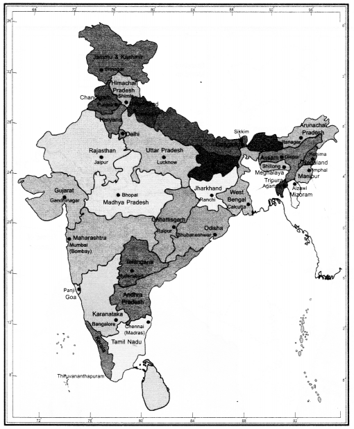
- Hyderabad is the Joint Capital of Telangana and Andhra Pradesh.
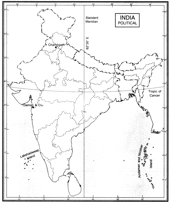
Question 52.
On the political map given locate and label the following.
(a) Tropic of cancer
(b) Standard meridian with degrees.
(c) Union Territories- Andaman and Nicobar, Lakshadweep, Chandigarh, Daman and Diu.
Answer:
We hope the given CBSE Class 9 Geography Chapter 1 Extra Questions India-Size and Location Pdf free download will help you. If you have any query regarding NCERT Extra Questions for Class 9 Social Science SST Geography Chapter 1 India-Size and Location, drop a comment below and we will get back to you at the earliest.