Composition and Structure of Atmosphere Class 11 Important Extra Questions Geography Chapter 8

Here we are providing Class 11 Geography Important Extra Questions and Answers Chapter 8 Composition and Structure of Atmosphere. Important Questions for Class 11 Geography are the best resource for students which helps in class 11 board exams.

Important Questions for Class 11 Geography Chapter 8 Composition and Structure of Atmosphere

Composition and Structure of Atmosphere Important Extra Questions Very Short Answer Type

Question 1.
How is the atmosphere held to the earth?
Answer:
The atmosphere is held to the earth by the force of gravity.

Question 2.
What is heterosphere?
Answer:
The layer of the atmosphere 90 km above the surface of the earth where the composition begins to change with a progressive increase in the lighter gases, is called heterosphere.

Question 3.
Which are the major constituents of clean dry air of atmosphere?
Answer:
Oxygen and nitrogen are the major constituents of clean dry air of the atmosphere.

Question 4.
Which gas of the atmosphere does not take part in a chemical reaction?
Answer:
‘Argon’ does not take part in a chemical reaction.

Question 5.
What are aerosols?
Answer:
Aerosols are huge amounts of s0lid and liquid particles present in the atmosphere.

Question 6.
Which gas despite its small percentage is crucial in atmospheric processes?
Answer:
Carbon dioxide is an important gas in the atmospheric processes.

Question 7.
What is the atmosphere?
Answer:
The atmosphere is a gaseous envelope extending thousands of kilometres above the earth’s surface.

Question 8.
What energises the atmosphere?
Answer:
The atmosphere is energised by the sun.

Question 9.
Where does much of life exist on the earth?
Answer:
Much of life exists at the bottom of the atmosphere where it meets the lithosphere and the hydrosphere.

Question 10.
Name two broad layers of the atmosphere.
Answer:
Homosphere and heterosphere are two broad layers of the atmosphere.

Question 11.
Name the three thermal layers of the homosphere.
Answer:
Troposphere, stratosphere and mesosphere.

Question 12.
What is wind?
Answer:
The horizontal motion of the air is known as wind.

Question 13.
Mention some forms of precipitation.
Answer:
Rain, hail, sleet or snow are some forms of precipitation.

Question 14.
Which gas acts as a filter and protects us from ultraviolet rays?
Answer:
Ozone gas protects us from the ultraviolet rays and acts as a filter.

Question 15.
Which layer transmits the radio waves?
Answer:
Ionosphere.

Question 16.
Name the gas which is found in the upper part of the atmosphere.
Answer:
Hydrogen.

Question 17.
What are the two causes of depletion of the ozone layer?
Answer:
Use of carbons and deforestation are the two causes of depletion of the ozone layer.

Question 18.
Name the gas which is most essential for life.
Answer:
Oxygen.

Question 19.
What are the principal elements of weather and climate?
Answer:
Temperature, pressure, wind, moisture and precipitation are the principal elements of weather and climate.

Question 20.
Why do the jet aircraft fly through the lower stratosphere?
Answer:
Because it provides the easiest flying conditions. It is the layer of calm and clean air. There is no water vapour and clouds are present.

Question 21.
What are the constituents of dust particles?
Answer:
Smoke-soot, ash, pollen are the main constituents of dust particles.

Question 22.
What is the weather?
Answer:
The cumulative effect of wind, temperature, pressure, clouds, humidity and precipitation is called weather.

Question 23.
What is the role of elements of weather?
Answer:
They influence temperature and precipitation.

Composition and Structure of Atmosphere Important Extra Questions Short Answer Type

Question 1.
Why are the vapour and dust particles important variables of weather and climate?
Answer:
The water vapour and dust particles are important variables of weather and climate because they are the source of all forms of condensation and principal absorbers of heat received from the sun or radiated from the earth. Besides, they affect the stability of the atmosphere.

Question 2.
What is meant by a normal lapse rate?
Answer:
The temperature decreases with altitude because the atmosphere is heated more by the heat radiated from the earth’s surface. Wanner air lying under the cooler air goes up or turns downward. In this layer, the temperature decreases vertically at a rate of 0.65°C per 100 metres. It is called the normal lapse rate.

Question 3.
What is homosphere?
Answer:
The atmospheric layer up to an altitude of 90 km. above the surface of the earth is generally called homosphere. It is uniform in term of these major gases – nitrogen, oxygen and argon. In addition, it also contains some rare gases like neon, krypton and xenon.

Question 4.
Name the gases and other materials which compose the atmosphere.
Answer:
Nitrogen, oxygen and argon are the most important gases of the atmosphere. In addition, it contains gases like carbon dioxide, neon, helium, ozone, hydrogen, methane, krypton and xenon. Besides, there are also present huge amounts of solid and liquid particles collectively called aerosols.

Question 5.
Discuss the properties of nitrogen gas.
Answer:
Nitrogen is the most abundant gas of the atmosphere. By volume, it constitutes 78.8% of the total gases present in the atmosphere. Nitrogen does not easily enter into chemical union with other substances but gets fixed into the soil. It serves mainly as diluent or dissolver. It regulates combustion.

Question 6.
What is the importance of carbon dioxide on the earth?
Answer:
By volume carbon dioxide constitutes 0.03% of the total gases of the earth’s atmosphere. Although it forms a small portion, it is an important gas in the atmospheric processes. It can absorb the heat and thus allows the lower atmosphere to be warmed up by heat radiation coming from the sun and from the earth’s surface. Green plants in the process of photosynthesis utilise carbon dioxide from the atmosphere.

Question 7.
Explain the difference between weather and climate.
Answer:
The weather of any place is the sum total of its temperature, pressure, winds, moisture and precipitation conditions for a short period of time. Climate, on the other hand, is the composite weather conditions over a considerable period of time.

Question 8.
Identify the climatic controls.
Answer:
The various climatic controls are given below :

  1. Latitude or sun.
  2. Distribution of land and water
  3. The great semi-permanent high and low-pressure belts
  4. Winds
  5. Altitude
  6. Mountain barriers
  7. Ocean currents
  8. Storms of various kinds

Question 9.
What is the importance of the atmosphere for the earth?
Answer:
The earth is the only known planet to have life. The atmosphere, which is unlike that of any other planet, encircles and protects the earth. Changes in the composition of the atmosphere are closely associated with the evolution of the earth. One of the most important transition was the increase in oxygen when photosynthetic plants evolved.

The atmosphere is a mixture of gases, the largest proportion of which is nitrogen. However, the most important is oxygen, without which life could not be sustained. The very survival of life processes is associated with the atmosphere.

The influence of the atmosphere on humans particularly is not only direct but also indirect through natural vegetation, soil and topography.

Question 10.
What is tropopause?
Answer:
The tropopause is the plane which separates the troposphere and stratosphere. It is the boundary between these two layers. It is a thin transitional zone between two layers.

Question 11.
Explain three major features of the troposphere.
Answer:
Three major features are :

  1. It is 16 km thick at the equator and 10 km thick at the poles.
  2. The temperature decreases with the altitude at the rate of l°C per 165 metres.
  3. Biological activities take place in this layer.

Question 12.
What are the main characteristics of the lowermost layer of the atmosphere?
Answer:
The lowermost layer is the troposphere.

  • Its average height is 16-18 km.
  • All biological activities occur in this layer.
  • All the atmospheric processes take place in this layer.
  • It is 16 km thick at the equator and 10 km thick at the poles.

Composition and Structure of Atmosphere Important Extra Questions Long Answer Type

Question 1.
Distinguish between troposphere and stratosphere.
Answer:

TroposphereStratosphere
(1) It is the lowermost layer of the atmosphere.(1) It is the second layer of the atmosphere above the earth.
(2) Its height varies from 10-18 km. at the equator.(2) Its height is up to 50 km.
(3) Temperature decreases at the rate of 1 °C per 165 metres in this layer.(3) In this layer temperature is very low and fairly constant.
(4) It is the zone of convection currents of the atmosphere.(4) It is a zone of non-convection currents of the atmosphere.
(5) Water vapour, dust particles, clouds are found in this layer.(5) There is no water vapour but dust particles and clouds are found.
(6) Atmospheric processes occur in this layer.(6) This zone is free from atmospheric disturbances.

Question 2.
What is the difference between condensation and precipitation?
Answer:
Condensation is the physical process of the transition of a substance from the vapour to the liquid state, e.g., as a result of cooling or increase of pressure. It occurs in the atmosphere when the air is saturated or when it is cool. Thus, the change of state of the moisture from invisible water vapour to visible liquid (water) or solid (ice or snow ) state is known n as condensation. It is opposite of evaporation.

Precipitation, on the other hand, means ‘throwing down of moisture’. Continuous condensation in the body of the air helps the water droplets to grow in size so that the resistance of the air fails to keep them suspended. In such cases, only an ascending air current can keep them floating in the air. In the absence of such a current, the products of condensation begin to fall on the earth’s surface. The process whereby the water vapour first condenses in the air and then falls on to the earth is called precipitation.

Question 3.
Discuss the principal elements of weather and climate and the major climatic controls.
Answer:
The principal elements of weather and climate are temperature precipitation, moisture, pressure and winds. These are called elements because they are the ingredients out of which various weather and climate types are compounded. The temperature and precipitation are the main basic elements to which pressure, winds and other elements are related.

Temperature expresses the intensity of heat. Practically all the heat energy on the earth is the result of insulation or the increasing solar radiation. Unequal distribution of temperature over the earth’s surface causes differences in atmospheric pressure, which causes winds.

Higher the temperature, the greater is the capacity’ of air to hold moisture on cooling. The air is not able to retain all the moisture it gathers while warm. This leads to condensation and precipitation.

Thus, the temperature is the basic element on which other elements of climate depend.

The climatic controls are :
Latitude (or sun), distribution of land and water, the great semi¬permanent high and low-pressure belts, winds, altitude, mountain barriers, ocean currents and storms of various kinds.

Question 4.
Define the atmosphere. Explain its importance to human life.
Answer:
The atmosphere is a mixture of air and various gases which envelopes the earth all around. It represents the gaseous realm of the earth. It is held to the earth by the force of gravity.

Importance of atmosphere:

  1. It contains gases like oxygen (essential for breathing) for man and animals and carbon dioxide for plants.
  2. By trapping the heat, it acts as a greenhouse. It keeps the earth
    warm.
  3. One of its layer, the ionosphere, reflects radio waves back to the earth and makes radio communication possible.
  4. It protects us from the deadly cosmic rays and meteors which are continuously showered on the earth from outer space.
  5. All the weather phenomenon take place in the atmosphere. Presence of water vapour in the atmosphere brings many changes such as condensation and precipitation. These processes influence the human life, plants and animals.
  6. It absorbs ultraviolet rays.
  7. It acts as an air conditioner by moderating the extremes of heat ‘ and cold.
  8. It is a storehouse of water vapour.

Question 5.
Discuss the proportion of the constituent gases of the atmosphere.
Answer:
The atmosphere is a mixture of various gases. It includes :
Nitrogen (N,), Oxygen (O,), Argon (Ar), Carbon dioxide (CO,), Neon (Ne), Helium (He), Ozone (O,), Hydrogen (H), Methane (CH4), Krypton (Kr) and Xenon (Xe).

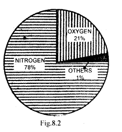
Nitrogen (N2): It is a colourless, odourless gas, the main constituent (i.e. 78.8% by volume) of the atmosphere. It is an essential constituent of living organisms. It is an important element for plants.

Oxygen (O,): Constitutes 20.94% of the total volume of the atmosphere. It is the second most abundant gas. It is essential to plant and animal life.

Argon (Ar): It constitutes one per cent volume of the total atmosphere. It is an inert gas, does not take part in any chemical reaction.

Carbon dioxide: It constitutes a very small amount (0.03%). It is an important gas in the atmospheric process. It can absorb heat and thus allows the lower atmosphere to be warmed up by heat radiation from the sun and from the earth’s surface. Green plants in the process of photosynthesis utilise carbon dioxide from the atmosphere.

Neon (Ne): Neon is an inert gaseous element occurring in’ trivial quantities (0.0018%) in the atmosphere.

Helium (He): It exists primarily in the sun’s atmosphere. It is an inert element of the atmosphere.

Ozone (03): It is an allotropic form of oxygen (02). Its main concentration lies between 20 to 25 km. from the earth’s surface.

Hydrogen (H): It is the lightest element. It is gaseous and inflammable. It is used in many chemical processes.
Class 11 Geography Important Questions Chapter 8 Composition and Structure of Atmosphere im-1

Landforms and their Evolution Class 11 Important Extra Questions Geography Chapter 7

Here we are providing Class 11 Geography Important Extra Questions and Answers Chapter 7 Landforms and their Evolution. Important Questions for Class 11 Geography are the best resource for students which helps in class 11 board exams.

Important Questions for Class 11 Geography Chapter 7 Landforms and their Evolution

Landforms and their Evolution Important Extra Questions Very Short Answer Type

Question 1.
What is geomorphology?
Answer:
It is the study of landforms especially concerned with the genesis, evolution, and processes involved in the formation of the surface features of the earth.

Question 2.
What is the relief?
Answer:
The physical landscape of the earth’s surface is called relief. It includes mountains, valleys, plains, and plateaus.

Question 3.
Name various types of weathering.
Answer:
Chemical weathering, mechanical weathering, and biological weathering.

Question 4.
Arrange the following from smaller to bigger form: stream, gully, river, rill.
Answer:
Rill, gully, stream, river.

Question 5.
What is fiord?
Answer:
When a glacial trough formed near the sea gets filled up by the seawater, it is called a fiord. It is a deep steep-sided water inlet near the sea.

Question 6.
What do you understand by mud-flow?
Answer:
Mud-flow is a moving mass of solid waste fluid by rain or melting snow.

Question 7.
What is deflation?
Answer:
Deflation is the lifting and transporting of loose particles of clay and silt, collectively referred to as dust.

Question 8.
What is a landform?
Answer:
The landform is the shape, focus and volume of a specific physical feature of the earth’s surface produced by natural processes of erosion and deposition.

Question 9.
What is the combination?
Answer:
A combination is a form of chemical weathering caused due to the reaction of minerals with dissolved carbon dioxide in water.

Question 10.
Name two basic forms in which the running water acts as a geomorphic agent.
Answer:
As a geomorphic agent, the running water acts in two basic forms, namely overland flow and channel or streamflow.

Question 11.
What is a drainage basin?
Answer:
The drainage basin is a part of land drained by a sole river system.

Question 12.
What are three closely inter-related geomorphic works performed by rivers?
Answer:
Rivers perform three closely inter-related geomorphic works, viz., erosion, transportation, and deposition.

Question 13.
Give an example of badland topography.
Answer:
The valley of the Chambal in Madhya Pradesh is an example of badland topography.

Question 14.
What is Karst topography?
Answer:
Karst topography is a landscape formed by groundwater in a limestond1 region.

Question 15.
What is meant by water table?
Answer:
The top of the zone of saturated rocks is called the water table.

Question 16.
Why is wind action most prominent in arid and semi-arid areas?
Answer:
Wind action is most prominent in arid and semi-arid areas as there are loose particles of soil in these areas and wind can remove them easily.

Question 17.
Which areas on the earth’s surface depict landforms made by glaciers?
Answer:
The following areas on the earth’s surface depict landforms made by glaciers:

  1. High altitude areas,
  2. High mountain areas.

Question 18.
What is a glacier?
Answer:
The moving heap of ice and snow is termed a glacier.

Question 19.
How are lagoons formed? Give two examples of lagoons from India.
Answer:
Lagoons are formed when sand bars along the coast cut off a portion of the sea from the main water body. Example:

  1. Chilka lake (in Orissa),
  2. Pullicat lake (Tamilnadu).

Question 20.
Where are areas of permanent snow or ice found over the surface of the earth?
Answer:

  1. Areas or regions situated at high latitudes.
  2. Areas situated at very high altitudes irrespective of their distance from the equator.

Question 21.
What acts as cutting tools for the sea waves?
Answer:
Loose pieces of rocks and sand suspended in the sea waves.

Question 22.
What is marine erosion?
Answer:
Marine erosion is the erosion of rocks in the coastal areas, carried out by the sea waves.

Question 23.
Where are lagoons mostly found in India?
Answer:
On the Malabar coast of India.

Question 24.
Where is the Marine beach situated in India?
Answer:
Marine beach is situated in Chennai on the Coromandel coast.

Question 25.
What is the distance covered by a rapidly moving glacier in a day?
Answer:
4 kilometres per day.

Question 26.
Where is wind most important as an agent of gradation?
Answer:
In arid and semi-arid regions.

Question 27.
Enumerate various forms made by wind action.
Answer:

  1. Wind eroded basin,
  2. Loess plains,
  3. Sand dunes.

Question 28.
Where do the sand dunes originate?
Answer:
Sand dunes originate at the place where there is some obstruction in the way of the wind.

Landforms and their Evolution Important Extra Questions Short Answer Type

Question 1.
How would you explain the fact that the areas of permanent snow or ice are in high latitudes and very high altitudes?
Answer:

  1. Sun always shines perpendicular on the equator. Hence, equatorial regions get intense heat due to straight sun rays. As we go northwards or southwards from the equator, the sun’s rays become oblique and less heat is received in these regions. Hence, poles are always cold.
  2. Temperature decreases with increase in height at the rate of 1 °C per 165 metres height. Hence, as we go above from the equator, fewer temperatures are observed. A height comes when the temperature is below freezing point and snow and ice rules over.

Question 2.
What are snowfields? Where are they generally situated?
Answer:
The vast areas which are permanently covered with snow and ice are called snowfields.

The snowfields are generally found situated above the snow line.

  1. High latitudes and polar regions,
  2. Near mountain tops.

Question 3.
What is meant by ‘moraines’?
Answer:
Glaciers carry pieces of rocks, big and small, with them. They deposit them at certain places – at their edges, on the bottom, at the terminals and the central zone of two glaciers. These deposits are called moraines.

Question 4.
Define loess plateau?
Answer:
Loess is the deposit of sand blown over long distances and deposited over large areas. When the thickness of the loess is hundreds of metres, it assumes the name of loess plateau.

Question 5.
Write a short note on the formation of sand dunes.
Answer:
Wind deposits sand brought by it as sand dunes. The major features of these sand dunes are as follows:

  1. A sand dune is a typical hill. It has a crest.
  2. It is generally mobile as it goes on shifting along the direction of the prevailing wind.
  3. Obstructions in the path of the wind lead to the formation of the sand dunes.
  4. Sand dunes vary in size. They vary from a few metres to 300 metres in height.

Question 6.
Distinguish between stalactite and stalagmite.
Answer:

StalactiteStalagmite
Deposits of lime hanging downwards from the ceiling are of a cave are called stalactitesdeposits of lime taking place upwards from the floor of an ave are termed as stalagmites.

Question 7.
Distinguish between beaches and sand bars.
Answer:

BeachesSand Bars
(1) Beaches. are deposits of sand and gravel along the coast.(1) Sand bars are embank¬ments of sand and gravel built by the wave action on the seafloor at a short distance from the coast,
(2) Example: Marine beach in Chennai.(2) Example: Sand bars along the coast of Kerala.

Question 8.
What is a fiord?
Answer:
When a glacial trough formed near the sea gets filled up by the seawater, it is called a fiord. Thus a fiord is a deep, steep-sided water inlet near the sea. It is typical of Norwegian and Chilean coasts.

Question 9.
What is ‘regolith’?
Answer:
Regolith is a layer of loose or soft material lying above the bedrock. When regolith is formed by decomposition and disintegration of the bedrock that lies directly beneath it, it is called residual regolith. The regolith transported by steam, ice, water and deposited elsewhere is called transported regolith.

Question 10.
Define fluvial denudation.
Answer:
Running water is undoubtedly the most important agent of denudation. It is most conspicuous as a stream or river that transports enormous volumes of surplus precipitation from the land to the ocean. Stream action, in combination with weathering, mass wasting and overland flow, is responsible for the total process called fluvial denudation.

Question 11.
Explain two forms of the flow of running water as the geomorphic agent.
Answer:
Running water acts as a geomorphic agent in two basic forms, viz., overland flow and channel or streamflow.

Overland flow is the movement of run-off downhill on the ground surface in a more or less broadly distributed sheet or film. Second is channel flow or streamflow in which water moves to lower levels in a long, narrow, trough-like feature called stream-channel, bounded on both sides by rising shapes called banks that contain the flow.

Question 12.
Discuss the features developed due to falling rain on bare surfaces.
Answer:
Gentle rain falling on bare surfaces loosens the soil and muddies the water. The muddy water flows as the thin, slow-moving surface layer of water called sheet flow. As the slope increases, the water scours additional sediments and erodes small channels, which are called rills. Headward erosion of rills and their subsequent widening leads to gully formation. Gullies dissect the land into a number of isolated hills, giving rise to badland topography.

Question 13.
Discuss the internal and external forces involved in the creation of landforms.
Answer:
A host of internal and external forces are involved in the creation of landforms. Tectonic forces crumple rocks and push up continents and mountain ranges. Moving water, air and ice erode rocks and transport the eroded debris to depositional sites and thus change the appearance of the landscape with the passage of time. The intensity of these agencies varies from one region to- another depending on climate, vegetation and altitude.

Question 14.
How is a U-shaped valley formed?
Answer:
A glacier does not make its own valley. When a glacier enters a V-shaped river valley, it modifies it into a U-shaped valley. The valley is deepened as the pressure of ice increases. A wide, flat structure is formed. Due to side cutting the valley is widened, and it is known as U-shaped valley.

Question 15.
On what factors the erosional work of the river depends?
Answer:
The erosional work of the river depends upon the following factors:

  1. Volume of water
  2. The slope of the river
  3. Load of the river
  4. Velocity of water
  5. The nature of the rocks

Landforms and their Evolution Important Extra Questions Long Answer Type

Question 1.
Discuss features created by wave action.
Answer:
At the shoreline, the line along which the water meets the land, the major erosive agent is wave action. Along the coast of hard rock, a gently inclined rock surface is carved out to accommodate the swash and backwash. It is called abrasion platform. A shoreline rising abruptly from the abrasion platform is called a marine cliff. The stormy waves thrust rock fragments with great violence against the cliff base to develop wave-cut notches or sea-caves. Relatively thick and gently sloping accumulation of sand, gravel or cobbles in the zone of breakers and surf is called beads.
Class 11 Geography Important Questions Chapter 7 Landforms and their Evolution im-1

Question 2.
Write an essay on the geomorphic work of rivers,
Answer:
Rivers are the stream channels organised into branching channel network. Rivers perform three closely interacted geomorphic works, viz.,

  1. erosion,
  2. transportation,
  3. deposition. River erosion is the progressive removal of minerals from the surface of stream channel which itself may consist of the bedrock of regolith. River transportation is the movement of eroded particles in a chemical solution, in turbulent suspension or 6y rolling and changing along the bed. River deposition consists of -accumulation of any transported particles on the stream bed on the adjoining flood plain or on the floor of a body of standing water into which the river empties. While the river performs all three functions simultaneously, one may dominate over the other in different parts of the river course.

The nature of river erosion depends upon the materials of which the channel is composed. Erosion is hydraulic action, the pressure and drag of flowing water exerted upon grains projecting from the bed and banks. Weak bedrock and various forms of regolith are easily carved out by hydraulic action. Abrasion occurs when rock particles carried in the current strike against the exposed bedrock of the channel. Small particles are reduced by crushing and grinding when caught between larger cobbles and boulders. The chemical reaction between ions carried in solution and exposed mineral surfaces result in a form of erosion called a solution.
Class 11 Geography Important Questions Chapter 7 Landforms and their Evolution im-2

Question 3.
How does wind affect rocks and what kinds of rocks are eroded the fastest? Explain the formation of landforms by winds.
Answer:
Winds are not strong enough to remove the mineral matter from hard rocks, moist clay or soil rich in vegetation. They can only affect those rocks which are soft, arid and vegetation less. Hence rocks which are soft are eroded the fastest.

Formation of landforms by winds: Winds form landforms both during erosional and depositional work.

Erosional landforms – Winds erode loose particles of soil and take them away. In course of a time, a hollow is formed in the desert surface. This is called a wind-eroded basin.

Depositional landforms – When the wind becomes weak and some obstacle lies in its path, deposition of transported loose particles begin to take place. Wind becomes weak due to the decrease in its velocity. As a result of the depositions, sand dunes are formed. They are of different types and shapes.
Class 11 Geography Important Questions Chapter 7 Landforms and their Evolution im-3
Class 11 Geography Important Questions Chapter 7 Landforms and their Evolution im-4

Question 4.
Which is the most important agent modifying the coastal topography? Describe the various features formed by this agent of gradation.
Answer:
The most important agent modifying coastal topography is sea waves. Sea waves erode, transport and deposit debris in the coastal regions and form both erosional as well as depositional features,

Erosional Features: Arches and Sea stacks: If the rock formation along the coast differs in resistance, softer rocks are eroded and harder remain to stand. This results in the formation of arches and stacks.

Depositional Features:

  1. Sea waves deposit sand, gravel and pebbles on the shore. These deposits are called beaches. Marine beach (Triplicane) in Chennai is famous in India.
  2. Sometimes sea waves deposit embankments of sand and gravel on the seafloor not far from the coast. These embankments are termed as bars. Very often ships strike against these bars and cause damage to themselves.
  3. Sometimes sand bars separate a portion of the sea from the main sea, giving birth to a lake lagoon. A lagoon is a saltwater .lake. These lakes have a connection with the main sea through sand and gravel along with the narrow outlets. Malabar coast in India abounds in lagoons. On the eastern coast, Chilka (in Orissa) and Pullicat (near Chennai) are two well-known lagoons.

Class 11 Geography Important Questions Chapter 7 Landforms and their Evolution im-5

Question 5.
Distinguish between:
1. V-shaped valley and U-shaped valley.
2. Valley glacier and Continental glacier.
3. Gorge and Canyon.
Answer:
1. V-shaped valley and U-shaped valley.

V-shaped valleyU-shaped valley
(1) Valley with slanting sides and the narrow bottom is called a V-shaped valley.(1) Valley with steep sides and flat bottom is called a U-shaped valley.
(2) It is formed by the action of running water.(2) It is formed by the action of the glacier.
(3) Example: Ganga, Brahmputra valley.(3) Valley formed by Pindari glacier in the Himalayas.

2. Valley glacier and Continental glacier.

Valley glacierContinental glacier
(1) Glaciers formed in the high mountains are long and narrow as they occupy former river valley, and are termed as valley glacier.(1) Glaciers formed in polar and arctic regions over extensive areas are called continental glaciers.
(2) Example: Siachen glacier.(2) Example: Antarctic glacier.

3. Gorge and Canyon.

GorgeCanyon
(1) A gorge is a narrow deep opening of the river across a mountain.(1) Canyon are formed in dry areas.
(2) Side cuttings are absent due to hard rocks.(2) It has high vertical walls for long distances.
(3) The river’s downcutting leads to the formation of deep gorges(3) The upper part of the canyon is wide due to weathering.
(4) The lower part is deeper due to rapid downcutting

Geomorphic Processes Class 11 Important Extra Questions Geography Chapter 6

Here we are providing Class 11 Geography Important Extra Questions and Answers Chapter 6 Geomorphic Processes. Important Questions for Class 11 Geography are the best resource for students which helps in class 11 board exams.

Important Questions for Class 11 Geography Chapter 6 Geomorphic Processes

Geomorphic Processes Important Extra Questions Very Short Answer Type

Question 1.
What are exogenetic forces?
Answer:
The external forces are known as exogenetic forces.

Question 2.
What are endogenetic forces?
Answer:
The internal forces operating from within the earth are known as endogenetic forces.

Question 3.
What is the degradation?
Answer:
The wearing down of relief is known as degradation.

Question 4.
What is the function of endogenetic forces?
Answer:
These forces continuously elevate or build up parts of the earth’s surface.

Question 5.
Name the various exogenetic elements.
Answer:
Water, air wind, ice, etc. are exogenetic elements.

Question 6.
How is energy generated within the earth?
Answer:
The energy within the earth is generated by radioactivity, rotational and tidal friction.

Question 7.
What is the effect of gravitational stresses?
Answer:
They activate wave and tide induced currents and winds.

Question 8.
What is orogeny?
Answer:
Orogeny is a mountain building process.

Question 9.
What causes earthquakes?
Answer:
Orogeny, epeirogeny, plate tectonics cause earthquakes.

Question 10.
Name the denudation processes.
Answer:
Weathering, mass wasting/movements, erosion and transportation are the denudation processes.

Question 11.
Name the different types of weathering.
Answer:
Weathering is of three types:-

  1. Chemical,
  2. Physical,
  3. Biological weathering.

Question 12.
What are the important agents of weathering?
Answer:
Frost, wind, heat, glacier and running water.

Question 13.
Name the two active factors of soil formation.
Answer:
Climate and living organisms.

Question 14.
What do you mean by exfoliation?
Answer:
It is the process of peeling off the outer layers from the main rock.

Question 15.
What is bad land?
Answer:
An area dissected with gullies and ravines.

Question 16.
What is humus?
Answer:
Humus is the organic matter of vegetable or animal organs in the soil.

Question 17.
How do organic soils develop?
Answer:
Organic soils develop from the accumulation of plant residues that are preserved by the low oxygen environment of shallow and stagnant waters.

Question 18.
Name the primary factors responsible for the development of soils.
Answer:
The primary factors responsible for the development of soils are parent material, climate, biota, topography and time.

Question 19.
What is eutrophication?
Answer:
Enrichment of water with nutrients, primarily phosphorous, causing abundant aquatic plant growth is called eutrophication.

Question 20.
Define soil profile.
Answer:
A vertical section of the soil through all its horizons and extending into the parent material is called a soil profile.

Question 21.
What is pedology?
Answer:
The branch of science that deals with the study of soil are called pedology.

Question 22.
What is added to the saline soil to reduce its salinity?
Answer:
Gypsum is added to the saline soil to reduce its salinity and make it useful for crops.

Question 23.
What are the mineral contents of laterites?
Answer:
The mineral contents of laterites include aluminium and iron oxide,

Question 24.
What makes the soil alkaline?
Answer:
Alkaline soils are formed in areas of low rainfall due to the accumulation or retention of lime.

Question 25.
Name the four soil-forming processes.
Answer:
The four soil-forming processes are eluviation, illuviation, Teaching and chelation.

Question 26.
What does ICAR stand for?
Answer:
ICAR stands for Indian Council of Agricultural Research.

Question 27.
Name eight soil groups as classified by ICAR.
Answer:
They are alluvial soils, black soils, red and yellow soils, laterite, arid, saline, peaty, organic and forest soils.

Geomorphic Processes Important Extra Questions Short Answer Type

Question 1.
What are geomorphic processes? Describe briefly.
Answer:
The endogenetic and exogenetic forces causing physical; stresses and chemical actions on earth materials and bringing about changes in the configuration of the earth’s surface are known as geomorphic processes. Diastrophism and volcanism are endogenetic geomorphic processes.

Question 2.
Distinguish between exogenetic and endogenetic forces.
Answer:
Exogenetic forces: The earth’s surface is being continuously subjected to external forces induced basically by the energy (sun). These external forces are known as exogenetic forces.

Endogenetic forces: The forces originating within the earth from its interior are known as endogenic forces. They are responsible for building up and wearing down of the earth’s surface.

Question 3.
What is directional force and what is its role?
Answer:
Gravity is a directional force. It activates the movements of matter and also causes stresses on the earth materials. Indirect gravitational stresses activate wave and tide induced currents and winds. Without gravity and gradients, there would be no mobility and hence no erosion.

Question 4.
What do you understand by oxidation?
Answer:
When atmospheric oxygen combines with minerals of rocks (especially with iron) to form oxides, the process is known as oxidation, v Rocks get rusted due to the presence of air and water. The rocks begin to decay and crumble to a powder mass of brown dust.

Question 5.
What is carbonation?
Answer:
Carbonation is the process in which rainwater gets mixed with carbon dioxide. It dissolves limestone, chalk and marble rock to form carbonates or bicarbonates with minerals. Calcium carbonates and magnesium carbonates are dissolved in carbonic acid.

Question 6.
What is weathering?
Answer:
Weathering means the weakening or wearing down, breaking up, rotting and disintegration of rocks at or over the earth’s surface.

Question 7.
What is chemical weathering?
Answer:
Chemical weathering is the decomposition of rocks by chemical methods. It results from the action of weak acids and gases like oxygen, carbon dioxide and hydrogen. Chemical weathering produces a chemical change in the minerals of rocks. High temperatures and humidity cause the rocks to decompose.

Question 8.
How does mass wasting take place?
Answer:
The force of gravity acts constantly upon the soil and bedrock. At various places, the internal strength of these materials is sufficient to keep them in place. But when the ground surface is sloping, the force of gravity is directed down the slope parallel with the surface. Every particle has least same tendency to roll or slide downhill and will do so whenever the downslope force exceeds the resisting forces of friction and cohesion that tend to bind the particles to the rest of the mass.

Question 9.
How does biota help in soil development?
Answer:
Biota is the collective term for the animal and plant life of a specific area as per the period of time. The decomposition of organic wastes and residues and the activities of living plants and animals have marked influence on soil development. Burrowing animals such as moles, prairie dogs, earthworms, ants and termites help soil development slowly by decomposing organic matter and forming weak acids that dissolve minerals faster. The roots of living plants and decomposed plant material release weak organic acids that help in weathering and soil development.

Question 10.
What is the pH value of soils?
Answer:
‘pH’ value means ‘potential hydrogen’, the standard measure of activity or Alkalimists in the soils. It is based on the activity of hydrogen ions in a litre of a solution, expressed in gram per litre. The pH value range from 0 to 14.0. Neutrality is at 3.0. Numbers lower than neutrality signify increasing acidity and higher numbers increasing salinity. Knowledge of the pH value of the soil under cultivation is most important in agriculture and horticulture.

Question 11.
What is saline soil?
Answer:
Because of the dry climate and poor drainage conditions, this soil acquires more salt. It is widespread in western Gujarat (Rann of Kutch), deltas of the east coast and Sunderban areas of West Bengal. Gypsum diminishes the salinity of soil and makes it useful for drops.

Question 12.
Distinguish between chelation and leaching.
Answer:
Leaching is the downward movement of material from a soil horizon in solution.

Chelation is also the downward movement of material, similar to leaching, but under the influence of organic complex compounds.

Question 13.
Discuss the role of topography in soil formation.
Answer:
The topography influences the soil formation through its relationship with relief, water and temperature. Steep hillsides have thin soil cover because of surface runoff that results in the erosion of the surface. On the other hand, gentle hillside preserves appreciable soil overdue to the luxuriant vegetation and sufficient water passing in vertically to deeper levels. The land-locked depressions receive a high amount of runoff water that favours appreciable vegetation cover but slower decomposition because of oxidation deficiency. This results in the formation of soil that is rich in organic matter.

Question 14.
How many essential elements are required by plants?
Answer:
Plants need at least 16 essential elements. They are carbon, hydrogen, oxygen, phosphorus, potassium, nitrogen, sulphur, calcium, iron, magnesium, boron, manganese, copper, zinc, molybdenum and chlorine.

Question 15.
How are the exogenetic earth processes driven?
Answer:
Exogenetic earth processes are the external processes that are driven by solar energy. They act through the atmosphere and oceans where air and water come in contact with the lithosphere.

Geomorphic Processes Important Extra Questions Long Answer Type

Question 1.
What is the rock weathering? Discuss various ways in which it takes place.
Answer:
Rock weathering is the chemical decomposition and physical disintegration of rocks. Weathering takes place in three ways :

  1. Chemical weathering
  2. Physical or mechanical weathering
  3. Biological action

1. Chemical weathering: Chemical weathering is the decomposition of rocks by chemical methods. It results from the action of weak acids and gases like oxygen, carbon dioxide and hydrogen. Chemical weathering produces a chemical change in the minerals of rocks. High temperatures and humidity cause the rocks to decompose.

2. Physical or Mechanical weathering: The physical wear and tear of rocks is called mechanical weathering. In the middle and high latitude climates, and at high altitudes, alternate freezing and melting of water called frost action provide a powerful mechanism for breaking up of rocks. Water that penetrates joint planes and other natural openings in the rock expands when transformed into ice crystals. The pressure of the growing mass of such crystals causes joint blocks to be heaved up and pried free of the parent mass.

In the dry climates of low and middle latitudes, an important agent of rock disintegration is salt. The dry climates have long droughts in which evaporation can occur continuously causing water deep in the rock to be drawn surfaceward by capillary force. Near the rock surface, the moisture steadily evaporates permitting dissolved salts to be deposited in the opening of the rock. The growing salt crystals in this manner are capable of exerting pressure and disintegrating rocks.

The action of roots of growing plants exerting pressure upon the confining walls of rocks is yet another kind of mechanical weathering.

Biological weathering: When the breakdown of rocks and minerals is due to plants, animals and bacteria, it is called biological weathering. The main contribution of animals to weathering seems to be repeated mixing of soil material, thus bringing fresh material into exposure to the weathering agents. Snails are common in lime-rich ) areas and can wear deep holes in the limestone. Bird droppings may provide ‘ organic matter for the slant of soil formation and weathering.

Grazing by large animals loosens the soil, thus increasing surface runoff and soil erosion. Larger plants affect weathering in a number of ways. Cracks may be widened by root pressure. The accumulation of elements by plants and their return to the surface of the soil affects the nature of the soil and weathering profiles and the course of weathering. , Vegetation litter and decaying vegetation are important in conserving moisture which in turn enhances weathering.

Question 2.
Describe the geomorphic processes and how the gravity force affects the materials.
Answer:
The endogenetic and exogenetic forces causing physical stresses and chemical action on earth materials and bringing about changes in the configuration of the surface of the earth are known as geomorphic processes. The common geomorphic processes are diastrophism, volcanism, weathering, mass wasting, erosion and deposition.

Any exogenetic element of nature (like ice, wind, water, etc.) capable of acquiring and transporting earth materials can be called a geomorphic agent. When these elements become mobile due to gradients, they remove the materials and transport them over slopes. An agent is a mobile medium which removes, transports and deposits ‘ earth materials. Running water, groundwater, glaciers, wind, waves and currents, etc. can be called geomorphic agents.

Gravity is a directional force activating all downslope movements of matter and also causes stresses on the earth materials. Gravitational stresses activate wave and tide induced currents and winds. Without p gravity and gradients, there would be no mobility and hence no erosion, transportation and deposition are possible. So, the gravitational stresses are as important as the other geomorphic processes. Gravity force keeps us in contact with the surface and switches on the movement of all surface earth materials.

Question 3.
Write short notes on:-
1. Diastrophism,
2. Volcanism,
3. Exfoliation.
Answer:
1. Diastrophism: These are endogenetic processes. They include

  1. orogenic processes, involving mountain building through severe folding and affecting long and Harrow belts of earth’s crust,
  2. Epeirogenic processes, involving uplift or warping of large parts of the earth’s crust,
  3. earthquakes, involving local, relatively minor movement, and
  4. plate tectonics, involving horizontal movements of the crustal plates. In the process of orogeny, the crust is severely deformed into folds. Due to Epeirogency, there may be simple deformation. Orogeny is a mountain building process, whereas epeirogeny is a continental building process. Through the processes of orogeny, epeirogeny earthquakes and plate tectonics, there can be faulting and fracturing of the crust. All these processes cause pressure, volume and temperature (PVT) changes which in turn induce metamorphism of rocks.

2. Volcanism: Volcanism includes the movement of molten rocks towards the surface of the earth and also the formation of many intrusive and extrusive volcanic forms. In the process of volcanism, a host of landforms are created, including rock deformation, resulting in Domal folds and metamorphism of surrounding rocks due to intense heat.

3. Exfoliation: This is a type of physical weathering process unloading, thermal contraction and expansion and salt weathering. Exfoliation is a result and not a process. Spalling or flaking off of more or less curved sheets of shells from rocks or bedrocks resalts in smooth and rounded surfaces. Exfoliation can occur due to expansion and contraction induced by unloading and temperature changes. Exfoliation domes and tors result due to unloading and thermal expansion respectively. Granular exfoliation or disintegration, taking place especially due to salt weathering processes, also results in smooth and rounded surfaces.

Question 4.
Define and describe soil horizons.
Answer:
Soil horizons are the soil layers that are approximately parallel to the soil surface. Each horizon is different from the other. Boundaries between horizons range from indistinct to abrupt and clear. Horizons are formed because of differences in the degree of depth, amounts of humus accumulated, translocation of colloids by water and loss of colloids. Capital letters A, B, C, D and E are used to designate these horizons.

Horizons are commonly identified from the surface downwards.
Class 11 Geography Important Questions Chapter 6 Geomorphic Processes im-1
‘A’ horizon is the topsoil containing humus, from which materials are washed downwards by percolating water (leaching) so that it is termed an eluvial (eluviation) horizon.

‘B’ horizon or sub-soil lies beneath ‘A’ horizon. It is a horizon of deposition, of secondary enrichment, an illuvial horizon (illuviation) into which are deposited, the washed-out materials from ‘A’ horizon. Underneath is the ‘C’ horizon, it is the weathered parent material of the existing soil. Some soil scientists also distinguish ‘D’ horizon, the bedrock.

Question 5.
Discuss the factors responsible for soil formation and also the processes involved.
Answer:
Soil forming factors: There are five factors that influence soil formation, viz., parent material, climate, biota, topography and time.
1. Parent material: Parent material in soil science is weathered bedrock or the transported glacial or alluvial material. Soils from weakly cemented sandstone will be sandy and soils from shales will be shallow and fine-textured. Similarly, clay formation is favoured more by a high percentage of decomposable dark mineral and less by quartz.

2. Climate: Climate is an important active factor in soil formation. Several processes are involved in soil formation and may to some extent affect the soil profile.

3. Biota: Biota is the collective term for the animal and plant life of a
a specific area as per the period of time. The decomposition of organic wastes and residues and the activities of living plants and animals have marked influence on soil development. Burrowing animals such as moles, prairie dogs, earthworms, ants and termites help soil development slowly by decomposing organic matter and forming weak acids that dissolve minerals faster. The roots of living plants and decomposed plant material release weak organic acids that help in weathering and soil development.

4. Topography: Topography means relief features. Steep hillsides have thin soil cover because of surface runoff that results in the erosion of the surface. On the other hand, gentle hillside preserves appreciable soil cover due to the luxuriant vegetation and sufficient water passing in vertically to deeper levels. The landlocked depressions receive a high amount of runoff water that favours appreciable vegetation cover but slower decomposition because of oxidation deficiency. This results in the formation of soil that is rich in organic water. Thus, topography influences soil formation through its relationship with water and temperature.

5. Time: Soil formation is a very slow process. It may take a few hundred to a few thousand years. This period of time, however, varies from place to place, depending upon other factors discussed above (plant material, -biota, topography, climate). Under ideal conditions, a recognisable soil profile may develop in 200 years and under less favourable circumstances, it may extend to several thousand years.

Soil, forming processes: Several processes are involved in soil formation. These are:

  1. Eluviation: It is the mechanical translocation of clay or other fine particles down the profile.
  2. Illuviation: ft is the accumulation of the washed down material in the lower horizons of the soil profile.
  3. Leaching: It is the removal and downward movement of material from a horizon in solution.
  4. Cheluviation: It is a downward movement of the material, similar to leaching, but under the influence of complex organic compounds.

Minerals and Rocks Class 11 Important Extra Questions Geography Chapter 5

Here we are providing Class 11 Geography Important Extra Questions and Answers Chapter 5 Minerals and Rocks. Important Questions for Class 11 Geography are the best resource for students which helps in class 11 board exams.

Important Questions for Class 11 Geography Chapter 5 Minerals and Rocks

Minerals and Rocks Important Extra Questions Very Short Answer Type

Question 1.
What is meant by smelting?
Answer:
The process through which metals are separated from ores by using heat is called smelting.

Question 2.
Why are coal and petroleum called fossil fuels?
Answer:
Because they are associated with fossils (remnants of organisms).

Question 3.
Name two important sources of atomic energy found in India.
Answer:
Uranium and Thorium.

Question 4.
Define a rock.
Answer:
A rock is any natural mass of mineral matter that makes up the earth’s crust.

Question 5.
Name the types of rocks.
Answer:
The three types of rocks are the igneous rocks, the sedimentary rocks and the metamorphic rocks. ‘

Question 6.
Which are two main types of igneous rocks?
Answer:
On the basis of chemical differentiation of magma, there are two types of igneous rocks, viz., mafic and felsic.

Question 7.
What is meant by ‘texture? of the rocks?
Answer:
Texture relates to the sizes and patterns of the mineral crystals present in the rock.

Question 8.
Name the scale that grades between the size of mineral grains.
Answer:
The system of grading of mineral grains according to their size is called the Wentworth scale.

Question 9.
What is ‘phenocrysts’?
Answer:
Few large crystals embedded in a matrix of smaller crystals are known as phenocrysts.

Question 10.
What is ‘diagenesis’?
Answer:
It is the process of physical and chemical changes affecting sediments during their conversion into solid rocks.

Question 11.
What is the scientific study of rocks called?
Answer:
The scientific study of rocks is called petrology.

Question 12.
What does the term ‘lithosphere’ mean?
Answer:
The term lithosphere means a sphere of rocks.

Question 13.
Give two examples of soft rocks.
Answer:
Clay and chalk.

Question 14.
What kind of rock is granite?
Answer:
Granite is a coarse-grained igneous rock that is formed by the slow cooling of magma.

Question 15.
What happens to clay when it gets metamorphosed?
Answer:
It converts into slate.

Question 16.
What is metamorphism?
Answer:
Metamorphism is the change of form. It refers to the change in the form of rock when it is subjected to heat or pressure.

Question 17.
How many minerals have been identified and named till date?
Answer:
At least 2000 minerals have been named and identified till date.

Question 18.
Name the largest diamond ever found.
Answer:
Cullinan diamond is the largest diamond ever found.

Question 19.
What is the basic source of all minerals found in the earth?
Answer:
The basic source of all minerals is the hot magma in the interior of the earth.

Question 20.
What are ‘optical properties’ of minerals?
Answer:
Optical means ‘usual’. The optical properties of minerals are evaluated by means of a microscope using polarised light rays.

Question 21.
What are sedimentary rocks?
Answer:
The rocks which are formed by the accumulation of sediments are called sedimentary rocks.

Question 22.
Name three types of sedimentary rocks on the basis of their mode of formation.
Answer:

  1. Mechanically formed,
  2. Organically formed,
  3. Chemically formed.

Question 23.
Name the different types of coal.
Answer:
Peat, Lignite, Bituminus and Anthracite.

Question 24.
What is the thickness of lithosphere?
Answer:
The thickness of the lithosphere is about 100 km.

Question 25.
What are schists?
Answer:
Strongly developed foliation is known as schists.

Minerals and Rocks Important Extra Questions Short Answer Type

Question 1.
What is lithification?
Answer:
The fragments of the rocks are transported by various exogenous agencies and deposited. These deposits through compaction and/or cementation turn into rocks. This process is called lithification. In many sedimentary rocks, the layers of deposits. retain their characteristics even after lithification.

Question 2.
How would you classify the igneous rocks based on the size and nature of crystals?
Answer:
There are five types of igneous rocks based on the size and nature of crystals viz.

  1. rocks with phaneritic textured crystals
  2. rocks with orphan textured crystals
  3. equigranular textured rocks, and
  4. porphyritic textured rocks.

The crystals large enough to be seen with naked eyes or with the help of hand lens are called phaneritic textured crystals, whereas those too small to be distinguished without the aid of a microscope are – called orphan textured crystals of the igneous rocks. Where crystals in the rocks are all within the same size range, the texture is described as equigranular, whereas few large crystals are embedded in a matrix of smaller crystals, the texture is porphyritic.

Question 3.
Discuss the classification of sedimentary rocks into clastic and non-clastic division.
Answer:
Clastic means ‘broken’, describes clastic sediments consisting of particles removed individually from a parent rock source. The naming of clastic rocks depends on the size of component mineral grains.

The non-clastic sedimentary rocks are made of sediments of two basic types: chemical precipitates and organically derived sediments.

The chemical precipitates are solid mineral matters precipitated from an aqueous solution. The rock salt and gypsum are its examples. The organically derived sediments consist of remains of plants and animals as well as mineral matters produced by activities of plants and animals. Coal and limestone are examples.

Question 4.
What are schists?
Answer:
As metamorphism continues a large percentage of the minerals assume the plate-like shape and are assembled in parallel orientation in the rock, a structure is known as foliation. Strongly developed foliation is known as schist.

Question 5.
What is meant by mineral hardness?
Answer:
The degree to which a mineral surface resists being scratched is known as its mineral hardness. Hardness is important because it determines how a mineral is worn away by the abrasive action of stream, waves, wind and glaciers in the processes of erosion and transportation.

Question 6.
What are minerals and how are they formed?
Answer:
The mineral is a naturally occurring homogeneous solid that is an inorganic substance having an orderly atomic structure and definite chemical composition.

The basic source of all minerals is hot magma in the interior of the earth. When magma cools, crystals of mineral appear. These first crystals may sink in the magma so that the composition of the magma changes with depth. Thus, a sequence of minerals is formed in the rocks as the magma cools. Besides this, certain minerals such as coal, petroleum and natural gas are organic substances found in solid, liquid and gaseous forms respectively.

Question 7.
Describe the formation of sedimentary rocks.
Answer:
Sedimentary rocks are made from sediments deposited by the erosion and weathering of other rocks. Wind, water and snow erode rocks and carry the sediments to low lying areas. When deposited in the sea, they are compressed and hardened to form layers of rocks. Sediment is a fragmented mineral and organic matter derived directly or indirectly from pre-existing rocks and from life processes transported and deposited by air, water, etc. Chalk, sandstone, limestone, gypsum and coal are the examples.

Question 8.
What is mineral ‘lustre’?
Answer:
The appearance of a mineral surface under reflected light is referred to as its mineral lustre. It is described by several descriptive adjectives, such as metallic (metal like), adamantine (diamond), vitreous glass), resinous (oil), pearly or silky.

Question 9.
What do you understand by the specific gravity of minerals?
Answer:
Each mineral has a certain specific gravity. The specific gravity is the ratio of its density to the density of water at 4° Celsius. Mineral’s specific gravity is a property of great importance because it determines the density of a given rock and rock density, in turn, determines the gross layered structure of the earth.

Question 10.
What is the Deccan Trap?
Answer:
The Deccan trap is an extensive area in the north-west part of India. It covers about 5 lakh sq. km, area. It has been formed by lava flows. Lava has solidified to form basalt. It is useful for cotton cultivation.

Question 11.
How is coal formed?
Answer:
Vegetation is hurried in swamps and forests. Due to pressure of the overlying sediments, the remains of plants are changed into carbon. Coal is formed in this way. Coal is of different types such as peat, lignite, bituminous and anthracite.

Question 12.
What are the three types of rocks? Give two examples of each of them.
Answer:
The three types of rocks are:

  1. Igneous rocks
  2. Sedimentary rocks
  3. Metamorphic rocks

1. Igneous rocks: These rocks are formed by the cooling and solidification of molten lava and magma in the interior of the earth. Granite and basalt are examples.

2. Sedimentary rocks: These rocks have been formed by the deposition cementation of the fragments by exogenous means, i.e., wind, ice and sea. Examples are – sandstone and clay.

3. Metamorphic rocks: These rocks are formed by the change in colour, hardness, texture and mineral composition of the pre-existing rocks. Examples are – marble, slate.

Question 13.
What is meant by the texture of rocks?
Answer:
The texture means the size and pattern of the mineral crystals present in the rock. The size of the mineral crystals in an igneous rock depends largely upon the rate of cooling of magma.

Question 14.
Why fossils are preserved in sedimentary and not in igneous rocks?
Answer:
Sedimentary rocks are formed by the deposition of fragments ‘ carried away by exogenous means. They are deposited in distinct strata or layers. Fossils in the form of prints of leaves, insects or soft bovine animals and pieces of bones, shells or some hard parts of old living beings are embedded into layers of the sedimentary rocks. Thus, fossils are preserved in sedimentary rocks. The igneous rocks are formed by the solidification of magma. They are massive. They have no layers. Therefore, fossils cannot be preserved in igneous hard rocks and they are fossils-free.

Minerals and Rocks Important Extra Questions Long Answer Type

Question 1.
Write short notes on:
1. Sedimentary rocks
2. Types of metamorphism
Answer:
1. Sedimentary rocks: Exogenous agencies such as rain, wind, ice, running water, plants and animals are constantly hurried in rock disintegration producing loose and broken rock fragments in all sizes. These minerals are carried by wind, ice and running water in depressions such as lakes and seas on the earth’s surface. Such dropped materials are called sediments. Accumulation of these sediments in course of time gives rise to sedimentary rocks. The word ‘sedimentary’ is derived from the Latin word ‘sedimented’ means setting down. The sediments are usually deposited in distinct layers or strata. Therefore, these rocks are also known as stratified rocks.

2. Types of metamorphism: Metamorphism is the process of transformation of pre-existing rock into a new rock. Thus, metamorphic rocks are found when a rock is subjected to heat and/or pressure. Their characteristics are altered by forming new mineral forms. There are three types of metamorphism, viz. foliation, lineation and banding. When, under continued metamorphism, its minerals assume the plate-like shape and are assembled in parallel orientation in the rock, it is called foliation, e.g., Schist is formed in this manner.

When the mineral grains are drawn out into long, thin, pencil-like objects, all in parallel alignment, it is referred to as lineation. In another type of metamorphism, i.e., banding, the minerals of different varieties or groups are segregated into alternate layers. These layers are usually of light or dark shades, making the banding conspicuous.

Question 2.
What is the economic importance of minerals?
Answer:
Mineral resources can be divided into four main groups – essential resources, energy resources, metal resources and industrial resources. The most basic group, essential resources, comprises soil and water. Energy resources can be divided into fossil fuels (crude oil, natural gas, coal, oil shale and tar sand) and nuclear fuels (uranium, thorium and geothermal power). Metal resources range from structural metals such as iron, aluminium and titanium to ornamental and industrial metals such as gold, platinum and gallium.

Mineral deposits have two geological characteristics that make them a real challenge to modem civilization. First, all of them are non-renewable resources. The geological processes that form them are much slower than the rate at which we exploit them. There is no likelihood of our ability to grow mineral deposits at a rate equal to our consumption. Second, mineral deposits have a place value. We cannot decide from where to extract them; nature made that decision for us when the deposits were formed.

Question 3.
Describe the categorization of metamorphic rocks.
Answer:
The metamorphic rocks can be broadly grouped into two major classes – cataclastic rocks and recrystallised rocks. Cataclastic rocks are formed by mechanical disruption (breaking and crushing) of the original materials. The process is described as dynamic metamorphism.

The recrystallised rocks are further divided into two sub-classes – contact and regional metamorphic rocks. The contact metamorphic rocks are formed by recrystallisation under high temperature caused by intruding magma. The rocks are not subjected to bending or breaking and new minerals emanating from magma are added to metamorphosed rocks. The regional metamorphic rocks undergo recrystallisation during the process of being deformed by sharing often under the condition of high pressure or high temperature or bolts.

Question 4.
Discuss various types of rocks in detail.
Answer:
There are three main groups of rocks: igneous, sedimentary and metamorphic rocks.
Igneous rocks: These are formed from lava hurled out of a volcano or from the cooling of hot magma below the crust. Granite is a coarse-grained rock that was formed by the slow cooling of magma. Basalt is a fine-grained igneous rock, almost black, that was formed by quick cooling of lava. Chemical differentiation of magma gives rise to mafic and felsic types of igneous rocks.

The size of mineral crystals in an igneous rock largely depends upon the rate of cooling of magma. As a general rule, rapid cooling results in small crystals and slow cooling in large crystals. Extremely sudden cooling results in the formation of a natural glass which is non-crystalline. Large bodies of magma trapped beneath the surface cool very slowly because the surrounding rocks conduct the heat slowly. Rapid cooling occurs in lava that loses heat rapidly to the atmosphere or to the overlying ocean water.

Question 5.
Describe the formation of igneous rocks, giving suitable examples of various types.
Answer:
The igneous rocks are divided into extrusive rocks and intrusive rocks. When the magma solidifies on the surface of the earth, we call it an extrusive rock. A typical example of this kind of rock is basalt. It is a very fine-grained rock, usually Sf black in colour.

On the other hand, when the magma solidifies in the crust, below the surface, it is called an intrusive rock. The few most common examples of intrusive rocks are granite and dolerite. More frequent, however, is the solidification of magma below the earth’s surface leading to the formation of intrusive rocks. Igneous rocks are classified on the basis of chemical composition and texture. Chemical differentiation of magma gives rise to mafic and felsic types of igneous rocks.

Texture relates to the sizes and pattern of the mineral crystals present in the rock. The size of mineral crystals in an igneous rock depends largely upon the rate of cooling of magma. As a general rule, rapid cooling results in small crystals and slow cooling results in large crystals. Extremely sudden cooling results in the formation of natural glass which is non-crystalline. Large bodies of magma trapped beneath the surface cool very slowly because the surrounding rocks conduct the heat slowly. Rapid cooling occurs in lava that loses heat rapidly to the atmosphere or to the overlying ocean water.

Distribution of Oceans and Continents Class 11 Important Extra Questions Geography Chapter 4

Here we are providing Class 11 Geography Important Extra Questions and Answers Chapter 4 Distribution of Oceans and Continents. Important Questions for Class 11 Geography are the best resource for students which helps in class 11 board exams.

Important Questions for Class 11 Geography Chapter 4 Distribution of Oceans and Continents

Distribution of Oceans and Continents Important Extra Questions Very Short Answer Type

Question 1.
What is Pangaea?
Answer:
All landmasses of the world have been formed from one super¬continent called Pangaea.

Question 2.
Who first propounded the theory of continental drift?
Answer:
Alfred Wegner propounded the theory of continental drift in 1912.

Question 3.
Which plate is composed of mainly oceanic crust?
Answer:
The Pacific plate is composed of mainly oceanic crust.

Question 4.
How did the Himalayas rise?
Answer:
The collision between the Indian Plate and the Eurasian plate took place north of the Indian plate giving rise to the Himalayas.

Question 5.
What is the evidence in support of continental drift theory?
Answer:

  1. Geological matching
  2. Palaeoclimatic unity, and
  3. Palaeornagnetism.

Question 6.
Name the continents into which the supercontinent, Pangaea, got split.
Answer:
They are Laurasia and Gondwanaland.

Question 7.
How many years ago Pangaea, the supercontinent has evolved?
Answer:
Pangaea, the supercontinent, had evolved some 280, million years ago.

Question 8.
What are hot spots?
Answer:
The centers of volcanic activity are called hot spots.

Question 9.
Name the three kinds of boundaries based on their Relative motion.
Answer:

  1. Zones or margins of divergence or spreading,
  2. Margins of convergence, and
  3. Fracture zones or transform faults.

Question 10.
How many plates the lithosphere is divided into?
Answer:
Seven plates.

Question 11.
The collision between which two plates gave rise to the Himalayas?
Answer:
The collision between Indian and Eurasian plates gave rise to the Himalayas.

Question 12.
Name two fossils that tell us that continents were once united.
Answer:
The fossils of the plant Glossopteris and animals Mesosaurus and Lystosaurus, suggests that these continents were once joined.

Question 13.
What is Palaeornagnetism?
Answer:
It is the fossil magnetism evident today in igneous rocks such as magnetite, hematite, pyrrhotite, etc.

Question 14.
What is the Pacific plate?
Answer:
The latest plate in terms of its formation or origin.

Question 15.
What do you understand by the spreading of crust from the ridge and the widening of the ocean basin?
Answer:
It is the seafloor spreading.

Question 16.
Name the northern and southern parts of Pangaea.
Answer:
Laurasia and Gondwanaland.

Question 17.
Name the sea separating Laurasia and Gondwanaland.
Answer:
The Tethys sea.

Question 18.
In which parts Pangaea was split?
Answer:
Pangaea was split into northern continent Laurasia and Southern continent, Gondwanaland.

Question 19.
Name the original supercontinent. When was it formed?
Answer:
Pangaea. It was formed about 280 million years ago.

Question 20.
State three causes of plate movements.
Answer:

  1. Thermal convection,
  2. Hot spots of volcanic activity,
  3. Movement of currents.

Question 21.
What is meant by sea-floor spreading?
Answer:
The crust spreads away from the ridge and the ocean basin widens. This phenomenon is known as sea-floor spreading.

Question 22.
Name the process in which one plate overrides the other and the overriding plate slips down into the mantle and is submerged.
Answer:
Subduction.

Question 23.
What is thermal convection?
Answer:
It acts as a driving force for the movement of plates.

Question 24.
Name the four different types of plate interactions.
Answer:
Spreading, collision, subduction, and transform.

Question 25.
How was drifting of continents caused?
Answer:
It was caused by two forces :

  1. pole fleeing force, and
  2. tidal force.

Distribution of Oceans and Continents Important Extra Questions Short Answer Type

Question 1.
How do lithosphere plates behave along the transform fault?
Answer:
The lithospheric plates slide over each other, neither creating nor destructing any landmass. Instead, the. friction arising from the f* movement of the plates usually causes severe earthquakes and earth tremors.

Question 2.
Why do geographers focus their attention on plate boundaries?
Answer:
Geographers focus their attention on plate boundaries because each plate is a tectonic plate. It is rigid and moves as a single unit. Nearly all major tectonic activity occurs along the plate boundaries.

Question 3.
What does the term ‘supercontinent’ refer to?
Answer:
The term ’supercontinent’ refers to a single common geological landmass called Pangaea. It has been proposed that all landmasses of the world had formed from this ‘supercontinent’. Pangaea had evolved some 280 million years ago, at the end of the Carboniferous period and by mid-Jurassic age, 150 million years ago. Pangaea land split into Laurasia, the northern continent, and Gondwanaland, the southern continent. About 65 million years ago, i.e. at the end of the cretaceous, bound mainland were further broken up to give rise to several other continents such as South America, Africa, Australia, and Antarctica.

Question 4.
Discuss the causes of plate movement.
Answer:
Sub-crustal convection currents invoke the mechanism of thermal convection that acts as a driving force for the movement of plates. Hot currents rise, then cool as they reach the surface. At the same time, cool currents sink down. This convectional movement moves the crustal plates. .. Owing to current movements, the rigid plates of the lithosphere, which ‘float’ on more mobile asthenosphere, are in constant motion.

Question 5.
What is a geological time-scale?
Answer:
The chronology of the geological history’ of the earth is revealed by its rocks. Geological time scale indicates the hierarchy of time periods during which different rocks of the earth have formed.

Question 6.
What is subduction?
Answer:
The process in which the overridden plate slips down into the mantle and is submerged is known as subduction. Besides volcanism and shallow to deep-focus earthquakes, boundaries also formed deep trenches and folded mountains.

Question 7.
What is polar wandering?
Answer:
There has been a periodic change in the position of the magnetic pole. These changes are recorded in rocks by way of permanent magnetism. Unraveling of the signatures of such changes in the geologically old rocks by scientific methods provides the changing position of poles in geological time scale. It is known as ‘polar wandering’. It demonstrates that the continents have frequently moved and changed their direction of motion from time to time.

Question 8.
Account for the formation of the Himalayas according to the theory of plate tectonics in three points.
Answer:

  1. South-east Indian ocean ridge collided between the Indian plate and European plate. The Indian plate gave rise to the Himalayas.
  2. The suture between the Indian and Eurasian plates in the Himalayan region has been along the Indus and Brahmaputra.
  3. The mid-Indian ocean ridge has been spreading faster.

Question 9.
What is ‘Zolrt of Convergence’?
Answer:
Zone of Convergence is the boundary along which the edge of ‘ one plate overrides the other. It produces deep trenches and folds mountains. Volcanoes and deep-focus earthquakes mark it.

Question 10.
Describe the driving force for the movement of plates.
Answer:
The sub-crustal convection currents invoke the mechanism of thermal convection that acts as a driving force for the movement of plates. As these currents reach the surface, the hot current rises, then cools. Sometimes, cooler currents sink down. This type of convectional movement causes the movement of crustal plates.

Question 11.
Name the major plates of the earth. Which plate is composed of the oceanic plate?
Answer:
Pacific plate, Eurasian plate, Indo-Australian plate, African plate, North American plate, South American plate, and Antarctica plate are the major plates of the earth.

The zone of divergence is the boundary along which the plate is composed of mainly oceanic crust. It is known as the Pacific plate.

Question 12.
What is palaeoclimatic unity?
Answer:
The uniformity in the nature of the sediment in the biological past indicates that these continents were together in the geological past and experienced similar climatic conditions. It is the native of glacial deposits of the separated continents indicating that these continents were together in the geological past and experienced similar climatic conditions.

Distribution of Oceans and Continents Important Extra Questions Long Answer Type

Question 1.
What do you mean by ‘jig-saw-fit’? Describe the similarities found on the east and west coasts of the Atlantic ocean. What do they suggest?
Answer:
The ‘jig-saw-fit’ means the landmasses on the east and west coast of the Atlantic ocean can be fitted together. There are many similarities found on the two coasts :

  1. The Gulf of Guinea can be fitted into Cape San-Rogue of Brazil, the shoulder of Africa can be fitted into Gulf of Mexico, Western Europe and Eastern coast of North America along with Greenland can be fitted together.
  2. Gold deposits of Ghana lands are found on the east and in Brazil on the west.
  3. The glacial deposits are found in all landmasses of Gondwana land.

These similarities suggest that these continents were together in the geological past.

Question 2.
Discuss the Continental Drift Theory.
Answer:
Continental Drift Theory was proposed by Alfred Wegner in 1912. He postulated that all landmasses of the world have been formed from one super-continent called Pangaea.

The supercontinent, Pangaea, had evolved some 280 million years ago, at the end of the Carboniferous period and by the mid-Jurrasic age, 150 million years ago. Pangaea had split into a northern continent, Laurasia, and a southern continent Gondwanaland. About 65 million years ago, i.e., at the end of the Cretaceous, Gondwanaland further broke up to give rise to several other continents, such as South America, Africa, Australia, and Antarctica. Thus, the present distribution of the continental masses and the oceans are the n .uit of fragmentation of one or more pre-existing masses. These landmasses have drifted apart the intervening hollows having been occupied by the oceans.
Class 11 Geography Important Questions Chapter 4 Distribution of Oceans and Continents im-1
There are several pieces of evidence that suggest the existence of Pangaea. This evidence is available in the form of geological watching, palaeoclimatic units, and paleomagnetism.

Question 3.
Describe sea-floor spreading in brief.
Answer:
The present distribution of continents has taken place in the last 65 million years. The drift of continents still continues. The ridges down the middle of ocean floors have been emitting lava continuously. Those mid-oceanic ridges are cracks on the floor of the ocean where molten rocks push up to form a new crust. The crust spreads among the ridge and the ocean basin widens. This phenomenon is known as sea-floor spreading. The Atlantic ocean is getting smaller and the Red Sea is the part of a crack in the crust that will widen to produce new ocean millions of years ahead in the future. In the past, the widening of the South Atlantic ocean has separated Africa and South America.
Class 11 Geography Important Questions Chapter 4 Distribution of Oceans and Continents im-2

Question 4.
Explain the plate tectonic theory and its mechanism.
Answer:
Plate tectonic theory proves that the earth’s crust consists of several plates that carry continents and the ocean floors and float on the asthenosphere, moving very slowly, the movement probably resulting from currents in the asthenosphere. As shown in fig., the lithosphere is broken into seven major plates. They include :

  1. Pacific plate
  2. Eurasian plate
  3. Indo-Australian plate
  4. African plate
  5. North American plate
  6. South American plate
  7. Antarctic plate

The latest among these is the Pacific plate which is composed of oceanic crust almost entirely. The other plates have both continental and ocean crust. No plate consists of only continental crust. Plates range in thickness from about 70 km. beneath oceans to 150 km. under continents. Each tectonic plate is rigid and moves on a single unit. Nearly all major tectonic activities occur along the plate boundaries.

Based on the relative motion of plates, three kinds of plate boundaries have been recognized. They are :
1. Zones of divergence: These are boundaries along which plates separate and in the process of separation molten materials upwell. This is commonly observed along linear ocean edge where the new lithosphere is created in the form of new ocean floors. Active volcanism and shallow focus earthquakes make such boundaries,

2. Zones of convergence: There are the boundaries along which, the edge of one plate overrides the other. The overridden plate slips down into the mantle and is absorbed. This process is known as subduction.

3. Fracture zones or Transform faults: The plates slide past each other effect creating or destructing the boundaries. However, shallow focus earthquakes may result due to this friction.
Class 11 Geography Important Questions Chapter 4 Distribution of Oceans and Continents im-3

Question 5.
Describe the main features of the Indian plate.
Answer:
Indian ocean floor presents striking topography consisting of a number of elevated ridges and plateaus. Two of the ocean ridges, namely, the Mascarene Plateau, Chagos-Maldweep-Lakshadweep island ridge are said to be the volcanic tracts of two hot spots. The Northward extension of Ninety-east Ridge indeed in the trench which consumed the seafloor to the north of the Indian continental mass. The Chagos- Lakshadweep ridge linked the ancient Carlsberg ridge with the Southeast Indian ridge during the Eocene period (50 million years ago).

Consequent to the Carlsberg-Southeast Indian ocean ridge, the collision between the Indian plate and the Eurasian plate took place north of the Indian plate giving rise to the Himalayas. The suture between Indian and Eurasian plates in the Himalayan region has been along the Indus and Brahmputra rivers.