Here we are providing Class 11 Geography Important Extra Questions and Answers Chapter 13 Water (Oceans). Important Questions for Class 11 Geography are the best resource for students which helps in class 11 board exams.
Important Questions for Class 11 Geography Chapter 13 Water (Oceans)
Water (Oceans) Important Extra Questions Very Short Answer Type
Question 1.
What are brines?
Answer:
Brines are salt solutions commonly containing a higher portion of dissolved salt than that occurring in seawater.
Question 2.
How would you classify the large water bodies?
Answer:
The large water bodies can be classified into four groups, viz., oceans, intercontinental seas, enclosed seas and fringing seas.
Question 3.
Name four major oceans of the earth.
Answer:
The four major oceans of the earth are the Pacific Ocean, Atlantic Ocean, Indian Ocean and the Arctic Ocean.
Question 4.
Give three examples of intercontinental seas.
Answer:
They are Malays Sea, Central American Sea and the Mediterranean Sea.
Question 5.
Give a few examples of enclosed seas.
Answer:
Baltic Sea, Red Sea, Hudson Bay and the Persian Gulf are some examples of enclosed seas.
Question 6.
Identify some fringing seas.
Answer:
Baring Sea, Japan Sea, East China Sea, Andaman, California, North Sea, Laurentian Sea, Bass Sea, English Channel and Irish Seas.
Question 7.
What are the factors on which the amount of rainfall entering the soil depends?
Answer:
The amount of rainfall entering the soil depends upon the rate of rainfall and the infiltration rate of the soil.
Question 8.
What are the first order relief features of the earth?
Answer:
Continents and ocean basins are the first order relief features of the earth.
Question 9.
“The continental margins consists of two major submarine features.” Name them.
Answer:
They are the continental shelf and the continental slope.
Question 10.
Mention three types of features of the ocean basin floor.
Answer:
The ocean basin floor contains three types of features, viz.,
- abyssal plains and hills,
- oceanic rise and
- seamounts.
Question 11.
Name the second layer of oceans identified on the basis of their temperature structure.
Answer:
It is Theraseoline.
Question 12.
What is the major salt presents in the seawater?
Answer:
The major salt present in seawater is sodium chloride.
Question 13.
Name the deepest part of the ocean.
Answer:
The deepest part of the ocean is the Mariana Trench in the Pacific Ocean. It is from 11,034 m. deep below the sea level.
Question 14.
Where is the tallest sea mount situated?
Answer:
The tallest seamount is situated between Samoa and New Zealand which is 8690 m. high from the surrounding ocean floor.
Question 15.
What are the factors determining the salinity of seawater?
Answer:
The salinity of seawater depends upon the extent of evaporation, river discharge and precipitation.
Question 16.
What is residence time?
Answer:
The average time that an element remains dissolved in the ocean before removal is known as residence time.
Question 17.
How do you measure the salinity of seawater?
Answer:
It is measured in gm. of salt per thousand gm of seawater.
Question 18.
Why is the earth called Blue planet?
Answer:
Because of the abundance of water on its surface, the earth is often called a Blue planet.
Question 19.
What are oceanic deeps?
Answer:
Trough like depressions or trenches in the seafloor is called oceanic deeps. Deeps occur mostly at the convergence of plates in subduction zones.
Question 20.
How is the hydrological cycle expressed mathematically?
Answer:
The hydrological cycle is expressed mathematically as:
RF = RO + ET
RF includes all types of precipitations, RO is round off and ET is evapotranspiration.
Question 21.
Which is the largest ocean in the world?
Answer:
The Pacific Ocean.
Question 22.
Which sea has the maximum salinity?
Answer:
Dead Sea – 238 per thousand.
Question 23.
How much part of the earth is covered by the Pacific Ocean?
Answer:
1/3 part.
Question 24.
How much percentage of the earth is covered with water?
Answer:
71 % of the surface of the earth is covered with water.
Question 25.
What is the average salinity of ocean water?
Answer:
35 per thousand.
Question 26.
Name the two main banks of the world.
Answer:
- The Duggar bank,
- The Grand bank,
Question 27.
What percentage of the ocean floor is covered by the continental shelf?
Answer:
7.6%.
Water (Oceans) Important Extra Questions Short Answer Type
Question 1.
Why is earth called the ‘Blue Planet’?
Answer:
The earth is called a Blue planet because of the abundance of water found on the surface of the earth. Water covers 71 % of the earth surface.
If we take into account only the water surface of the earth, then 43% lies in the northern hemisphere and 57% in the southern hemisphere.
Question 2.
What are oceanic deeps?
Answer:
The oceanic deeps are deeper than the abyssal plains. They occupy 2% of the oceanic area. Although deeps are found in the Pacific ocean. Mariana deep is the deepest deep in the Pacific Ocean.
Question 3.
Name the most common features found on the ocean floor.
Answer:
The most common features found on the ocean floor are:
- Continental shelf
- Continental slope
- Submarine canyon
- Abyssal plains
- Submarine ridge
- Ocean deeps
- Troughs
Question 4.
Define the continental shelf.
Answer:
From the coasts towards the open sea, there often exists a stretch of the shallow sea. The bed of this shallow sea bordering the continental platform is known as the continental shelf. It is a continuation of the continental block submerged below the sea. It slopes gently towards the sea, the angle of slope usually being less than one degree. The depth of the shallow seas rushing over a continental shelf varies from low tide to about 100 fathoms. Along the eastern coast of India, there exists a fairly wide strip of the continental shelf.
Question 5.
What are oceanic deeps?
Answer:
Trough like depressions or trenches in the seafloor is called oceanic deeps. Deeps occur mostly at the convergence of plates in subduction zones.
Question 6.
What are seamounts?
Answer:
Seamounts are topographical features rising from the ocean floor. A seamount is an isolated peak, usually a volcano, with a pointed summit, usually lies below the ocean surface, sometimes 3000 m. below.
Question 7.
What is an abyssal plain?
Answer:
Abyssal plain is a deep-sea plain. It is a very large and relatively level area of the ocean floor, covered with a thin layer of sediment. Thus abyssal plain is an area of the deep ocean floor having a flat bottom with a very’ faint slope. Characteristically situated at the foot of the continental rise, the abyssal plain is present in all ocean basins. It is formed by long-continued deposition of very’ fine sediments and, therefore, has a nearly perfect flatness.
Question 8.
Write a short note on the continental rise.
Answer:
Continental rise is a submarine feature of the continental margins. Along its seaward margin, the continental shelf gives way to the continental slope. The slope is abruptly replaced by the continental rise. Continental rise is a surface of much gentler slope decreasing in steepness toward the ocean basin floor. It generally has a moderate to low relief.
Question 9.
What is runoff? How does it occur?
Answer:
Runoff is th§ water flowing from a drainage area. It is that part of precipitation which run off the land surface into streams. Runoff occurs when precipitation, that does not have an opportunity to infiltrate into the soil, flows across the land surface. However, most of it enters the stream channel ultimately, which carries it to the oceans. A part of precipitation that infiltrates the soil percolates downward to the water table through springs. Broadly speaking, runoff is composed of water from both surface flow and seepage flow. It is an extremely important-segment of hydrological cycles.
Question 10.
Discuss the factors affecting the distribution of temperature of the ocean water.
Answer:
The salinity of seawater varies from place to place. At the equator, the salinity is somewhat lower due to abundant rains, greater cloudiness and low rate of evaporation. In latitudes about 20° in both the hemispheres, where evaporation is more intense and precipitation is lower, salinity is greater and in the temperate latitudes, where evaporation is less and rains. are more abundant, salinity is lower.
In Red sea, where no river flows, the salinity is 40 to 41 per thousand. In the Black sea, in which numerous rivers discharge, the salinity is 17 to 18 per thousand. In the White sea. it is between 25 and 26 per thousand, while in the Baltic sea it is 3 to 4 per thousand on an average.
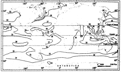
Fig. 13.4: Distribution of surface water salinity in oceans
Question 11.
Why is the seawater saline?
Answer:
The seawater is saline because a number of salts are dissolved in it. The total weight of salts dissolved in the sea is 4800 million tonnes. Of these, sodium chloride, or common salt, accounts for 3800 million tonnes, sulphate for 3000 million tonnes, magnesium for 1600 million tonnes, potassium for 480 million tonnes and bromide for 83 million tonnes. The seawater may be less saline or more saline depending upon the extent of evaporation, river discharge and precipitation, but salt composition remains invariable.
Question 12.
What are the direct and indirect uses of oceans to man?
Answer:
Oceans are directly or indirectly useful to man in many ways:
Direct uses of the oceans:
- Oceans are the storehouse of fishes.
- They are a storehouse of minerals.
- They provide the cheapest route for transportation.
Indirect uses: Indirectly-oceans control the climate.
Question 13.
How is the depth of seafloor measured?
Answer:
The depth of seafloor is measured with sound waves. A depth recorder is used for this purpose. The echo of the sound returning after striking the sea bottom forms the basis of it. It helps to measure the velocity and depth.
Question 14.
What do you understand by hydrosphere?
Answer:
The hydrosphere is the part of the earth submerged by oceans and seas. The vast oceans cover a total area of about 71% of the total earth’s surface. Earth is called a blue planet. Approximately 61% of the northern hemisphere and 81 % of the southern hemisphere is known as water hemisphere. The distribution of land and water is antipolar on earth. The Arctic Ocean surrounds the north pole and the Antarctic continent encircles the south pole.
Water (Oceans) Important Extra Questions Long Answer Type
Question 1.
Prepare a map of the Atlantic Ocean floor, mentioning ocean basins and mid-Atlantic ridges.
Answer:
The Atlantic Ocean covers about one-sixth of the earth’s area. Resembling ‘S’ in shape, the ocean is bounded on the west by North America and South America, and On the east by Europe and Africa. To the south, it extends up to Antarctica and in the north, it is bounded by Greenland and Iceland.
The mid-Atlantic ridge, running from north to south in ‘S’ form is about 14,450 km. long and about 4000 m. high. The ridge has a broad fracture in the middle and slopes on both sides gently. The mid-oceanic ridge in the North Atlantic is known as Dolphin Ridge, and that in the South Atlant ic as the Challenger Ridge. A number of islands are located on the ridge.
The mid-Atlantic ridge divides the ocean into two major basins, namely, the East and West Atlantic basins. Some other basins in the Atlantic are the North American basin, The Labrador basin, The Brazil basin. The Argentina, Agulhas, Angola, and the West.
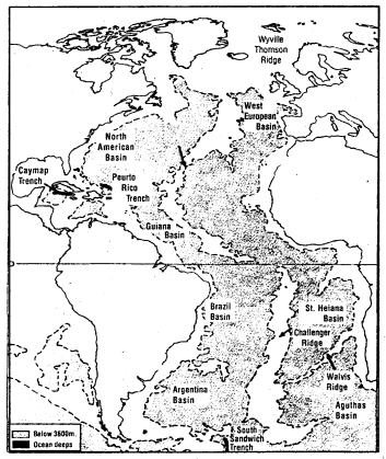
Fig. 13.3: Major Relief features of the Atlantic Ocean
Question 2.
What type of relief features exists in the ocean basin floor?
Answer:
The ocean basin is an extensive region of the basin floor, generally lying at a depth ranging between 2,500 and 6,000 m. It covers about 76.2% of the ocean’s area.
The ocean basin floor contains three types of relief features:
- abyssal plains and hills,
- oceanic rise and
- seamounts.
An abyssal plain is an area of the deep ocean floor having a flat bottom with a very faint slope. Characteristically situated at the foot of the continental rise, the abyssal plain is present in all ocean basins. Abyssal plains are surfaces formed by long-continued deposition of very fine sediments and, therefore, have a nearly perfect flatness. Abyssal hills are small hills rising to heights of a few tens of metres to a few hundred metres above the sea basin floor.
The ocean rise is an area hundreds of km. in the breadth over which the surface rises several hundred metres above the surrounding abyssal plain. Within the rise, the relief may range from subdued to very rugged.
Seamounts are the isolated peaks that rise 1000 ms. or more above the seafloor. Many of the seamounts are conspicuously flat-topped and extremely steep riched, named guyot.
Question 3.
Identify various layers of the ocean based on the level of salinity.
Answer:
The salinity of the water is the ratio of the total weight of dissolved
solids to the weight of water. It is variable in quantity, differentiating in value from place to place over the oceans and at various depths. The average salinity is 35 per thousand. The relationship of salinity to depth is analogous with the three-layer temperature systems.
- First and the topmost layer is the shallow surface layer of high salinity (35.0 to 36.5 per thousand)
- Below this layer is a zone of the rapid decrease in salinity, called a halocline. It corresponds with the thermocline.
- Below the halocline, differences in salinity’ are very small and salinity lies in the range of 34.6 to 34.9 per thousand for most of the ocean body. Thus, the salinity decreases with the increasing depth.
Question 4.
Discuss the longitudinal variation in the salinity of ocean water.
Answer:
The salinity of seawater varies from place to place. At the equator, the salinity is somewhat lower due to abundant rains, greater cloudiness and low rate of evaporation. In latitudes about 20° in both the hemispheres, where evaporation is more intense and precipitation is lower, salinity is greater and in the temperate latitudes, where evaporation is less and rains. are more abundant, salinity is lower.
In Red sea, where no river flows, the salinity is 40 to 41 per thousand. In the Black sea, in which numerous rivers discharge, the salinity is 17 to 18 per thousand. In the White sea. it is between 25 and 26 per thousand, while in the Baltic sea it is 3 to 4 per thousand on an average.
Fig. 13.4: Distribution of surface water salinity in oceans
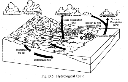
Question 5.
Describe the hydrological cycle in brief.
Answer:
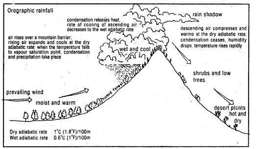
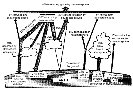
The hydrological cycle is the continuous circulation of water from the earth’s surface to the atmosphere. Water from the oceans is evaporated and lifted into the atmosphere. It is eventually condensed and is returned back to the earth’s surface in the form of rain, hail, snow or sleet.
Some of the precipitation, after wetting the foliage and ground, runs off over the surface to the streams. It is the water that sometimes causes erosion and is the main contribution to floods. Of the precipitation that soaks into the ground, some are available for growing plants and for evaporation. Some reach the deeper zones and percolates through springs and seeps to maintain streams during the dry period. The streams, in turn, eventually return the water back to the oceans where it originated. It is because of this never-ending circulation that the process has come to be known as the hydrological cycle.
The hydrological cycle is mathematically expressed as:
RF = RO + ET, where RF-includes all types of precipitation, RO is runoff and ET is evapotranspiration.
Runoff occurs when precipitation, that does not have an opportunity to infiltrate into soil, flows across the land surface. However, most of it enters the stream channel ultimately, which carries it to the oceans. A part of precipitation that infiltrates the soil percolates downward to the water table through springs. Broadly speaking, runoff is composed of water from both surface flow and seepage flow. It is an extremely important segment of the hydrological cycle. Rainwater that reaches the soil surface is wholly or partly absorbed by the soil in the process of infiltration. The amount of rainfall entering the soil depends upon the s* rate of rainfall and infiltration rate of the soil.