Structure and Physiography Class 11 Important Extra Questions Geography Chapter 2

Here we are providing Class 11 Geography Important Extra Questions and Answers Chapter 2 Structure and Physiography. Important Questions for Class 11 Geography are the best resource for students which helps in class 11 board exams.

Important Questions for Class 11 Geography Chapter 2 Structure and Physiography

Structure and Physiography Important Extra Questions Very Short Answer Type

Question 1.
Where did the Tethys sea exist?
Answer:
Tethys was present there where the Himalayas and northern plains are present today.

Question 2.
What are the main physical divisions of India?
Answer:

  1. Northern mountains,
  2. The Great Plains,
  3. Peninsular Plateau,
  4. Coastal Plains and
  5. Islands

Question 3.
What is the length and breadth of the Himalayas?
Answer:
Length is 2,500 km, breadth is 150 km to 400 km.

Question 4.
Name the four largest glaciers of India.
Answer:
Siachin, Hispar, Baii’o and Baltoro.

Question 5.
What do you mean by ‘duns’?
Answer:
These are the flat-floored valleys between Sivalik and Himachal.

Question 6.
What type of sand dunes are present in the ‘Thar desert’?
Answer:
Longitudinal, Barkhans, and Transverse type.

Question 7.
Name two passes of the Western Ghats.
Answer:
Thai Ghat and Bhor Ghat.

Question 8.
Name two rift valleys found in India.
Answer:
Narmada and Tapti.

Question 9.
Which plateau is found in the northeast of the peninsula?
Answer:
Shillong plateau.

Question 10.
What is the height of three peaks of Himalaya, having a height of more than 8,000 m.?
Answer:

  1. Mount Everest 8,848 m.
  2. Kanchenjunga 8,598 m.
  3. Annapurna 8,078 m.

Question 11.
Name the highest peak of the Alps mountain.
Answer:
Mont Blanc.

Question 12.
What is the name of the outer Himalaya?
Answer:
Shivalik.

Question 13.
Name the highest plateau of India?
Answer:
Ladakh.

Question 14.
Name the largest physiographic division of India.
Answer:
Peninsular plateau.

Question 15.
Name the important passes in the Himalayas.
Answer:
Jelepa, Nathula, Chola, Zojila, Patkoi, Bomdila, Changla, Karakoram, etc.

Question 16.
Which rivers drain in the Punjab plains?
Answer:
Satluj and Beas drain in Punjab.

Question 17.
What is ‘Marusthal’?
Answer:
The land which is inhabited by the Gonds, Santhali, Oraons, and Bhils is known as Marshal.

Question 18.
Name two Saline lakes of Rajasthan.
Answer:
Sambhar and Didwana are two saline lakes of Rajasthan.

Question 19.
Name the two major island groups in India.
Answer:
The Bay of Bengal and the Arabian Sea.

Question 20.
Where is Barren island located in India?
Answer:
It is located on the Nicobar Islands.

Question 21.
Name the important peaks of Nicobar islands.
Answer:
Saddle peak, Mount Diavolo, Mount Koyob, and Mount Thuiller.

Question 22.
Name the submerged coastal plain.
Answer:
Dwarak is the submerged coastal plain.

Question 23.
Which part of the north-western plateau has a complex relief of ravines and gorges?
Answer:
Chambal, Bhind, and Morena have complex relief of ravines and gorges.

Question 24.
In which period were the Aravallies uplifted?
Answer:
Vindhyan period.

Question 25.
Name the eastern boundary of the Deccan plateau.
Answer:
Rajmahal Hills.

Structure and Physiography Important Extra Questions Short Answer Type

Question 1.
“The peninsular plateaus and the Himalayas mountains are quite different from each other in respect of stratigraphy, geological structure, and physiography.” Comment.
Answer:
The northern mountains are young, weak, and flexible and have suffered from folding and deformation. The peninsula contains mostly residual mountains. Here, the river valley is shallow having low gradients. On the other hand, the Himalayas mountains are tectonic and rivers are torrential. The formation and development of the surface of the land like mountains, plateaus, and plains are called physiography.

Question 2.
What is Bhangar?
Answer:
The south of Terai is a belt consisting of old and new alluvial deposits known as Bhangar. These areas stand above the level of floodwater and the flood plains. This land is made up of clay pebbles and gravel. In Gangetic plains, these alluvial lands have been formed by the deposition of sandbars by the river.

Question 3.
What is Doab? Give few examples from India.
Answer:
The plain formed between two rivers is known as Doab. It separates two rivers but maintains its uniform character over the whole area. In Punjab, Doabs maintain the physical characteristics of the Punjab plain.

  1. Best Jalandhar Doab
  2. Bari Doab
  3. Chaz Doab
  4. Sind Sagar Doab

Question 4.
What is Karewas?. Where do they found?
Answer:
In the valley of Kashmir, the lake deposits comprise thick deposits of glacial clay and other materials embedded with maintaining, These deposits occur in the valleys within the Himalayan mountain where there was once glacial action and deposition of Morain.

Question 5.
State two important characteristics of the topographic complexity of the Himalayas.
Answer:
The young mountains of the Himalayas are formed by the internal horizontal earth movements. They have characteristic topographic. complexity.

  1. The Greater Himalayas, the Lesser Himalayas, and Shivalik are three main parallel ranges.
  2. These ranges have striking contrasts in their altitudes with snow-capped peaked, deep valleys, gorges, hanging valleys, ridges, etc.

Question 6.
Give three characteristics of the Himalayas, which indicate their youthful stage.
Answer:
There are many pieces of evidence collected by various geologists and archeologists to prove the youthfulness of the Himalayas. The follow ing evidence is given here :

  1. The presence of Karewas.
  2. In the sub-Himalayan region, fossils of post-tertiary mammals have been found which points to the upliftment during the Pleistocene times.
  3. The archeologists have collected curious stone tools that represent the paleolithic times, an early man in the terraces of Himalayan rivers.

Question 7.
Give the main points of difference in Himalaya mountains with Indian plateau.
Answer:

Himalayan MountainsIndian Plateau
(i) These are young new fold mountains.(i) Indian plateau is an ancient crystalline land
(ii) These mountains have been formed by the folding of earth.(ii) It has been formed as a horst.
(iii) The relief features of the young age of the Himalayas.(iii) Plateau is old and well dissected.
(iv) There are parallel mountain ranges formed.(iv) Rift valleys are formed.

Question 8. What is the difference between Eastern Himalaya and Western Himalaya?
Answer:

Eastern HimalayaWestern Himalaya
(i) Eastern Himalayas are extended from Sikkim to Assam between Tista and Brahmaputra river.(i) Western Himalayas are extended between Indus and Kali.
(ii) Strong monsoon brings heavy rainfall.(ii) Summers are warm and winter is vigorous cold.
(iii) Tropical wet evergreen forests grow.(iii) Area is snow-covered.
(iv) Relief features are relatively lesser complex.(iv) Alpine and temperate vegetation are found.

Question 9. Differentiate the Western Ghats and Vindhya Mountains.
Answer:

Western GhatsVindhya Mountains
(i) These are the extension of the south of the Malwa plateau.(i) They are flank the Deccan lava plateau on the west.
(ii) It is running to the Narmada river.(ii) They have altitude ranges from 900 to 1100 meters.
(iii) These are composed of sandstones, limestones, and shales.(iii) They are generally forested with a variety of vegetation.

Question 10.
What are the characteristics of the Andaman and Nicobar Islands?
Answer:
The main characteristics are :

  1. The Great Andaman is a collection of three islands, north, middle, and south.
  2. These are a group of islands.
  3. The south coast is very indented and has the highest hill ranges,
  4. There are 19 islands in Nicobar islands.

Question 11.
In which part of India, faulting evidence are found?
Answer:
The faulting has taken place on the Deccan plateau. The trough faulting is found in the valleys of Godavari, Mahanadi, Damodar, Tapi, and Narmada valleys are rift valleys. Faulting evidence is found on the Malabar coast and the Markan coast.

Question 12.
What is horst?
Answer:
A horst is the uplift land between two parallel faults. The central mass of the land keeps standing while the adjoining areas are thrown down. It forms the shape of a block mountain or a horst. For example Vindhyan and Vosges.

Structure and Physiography Important Extra Questions Long Answer Type

Question 1.
Describe in short the major physical division of India.
Answer:
India can be divided into the following physical divisions :

  1. The Great Mountains
  2. The Great Northern Plain
  3. The Great Peninsular
  4. The Great Indian Desert Plateau

1. The Great Mountains – These are formed by the continuous stretch of the mountain from Kashmir to Assam. It acts as a wall. They arc the Karakoram and the Himalayas. The Karakoram mountains lie between the Pamir plateau and the Indus River in the west. Baltoro is the famous glacier of the Karakoram range. They are very high mountains. The second Himalayas mountain chain stretch from the Indus river in the west to the Brahmaputra river in the east. Indus and Brahmaputra divide them into the main Himalayas, the western Himalayas, and the eastern Himalayas. The Garo hills, the Khasi hills, the Jaintia hills, and the Mikir hills form the Eastern Himalayas. They fall in the states of Arunachal Pradesh, Nagaland, Manipur, Assam, Mizoram, Tripura, and Meghalaya.

2. The Great Northern Plain – The great plains are composed of sediments deposited by rivers. They are quite extensive. The central and eastern parts of the plains have been formed by the tributaries of the Ganga and Brahmaputra rivers. Half of the Great plain lies in Uttar Pradesh and half in the state of Bihar.

3. The Great Peninsular Plateau – The peninsular plateau forms the largest physiographic division facing towards the Bay of Bengal and the Arabian Sea. It stretches from the Satpura range (north) to Kanyakumari (south) and from the Sahyadri (Western Ghats) to Rajmahal hills in the east. It is triangular in shape having four physiographic divisions: the Western Ghats, the Deccan Plateau, the Eastern Ghats, and Eastern Plateau.

4. The Greatest Indian Desert – It lies to the west of the Aravali ranges in Rajasthan. This is the region of moving sand and low rainfall, known as Marusthali. It was drained by the Saraswati, Drisadvati, and Satluj rivers. But today Llini is the only river. There are numerous salt lakes of which Sambhar is the largest.

5. Coastal Plains: The peninsular plateaus are bordered on the east and the west by the coastal plains. There are two well-known peninsulas, Kathiawar and Kachchh, on the west coast and an extensive plain of Gujarat. The east coast has a number of deltas. The west coast has no delta.

6. Island Groups – Arabian Sea and Bay of Bengal have a number of islands. They are called Lakshadweep, Andaman, and Nicobar islands. Andaman and Nicobar islands are the elevated portions of submarine mountains while the Lakshadweep Islands are built of coral deposits.

Question 2.
Write a short note on the saline lakes of Rajasthan.
Answer:
Rajasthan lies in the desert area to the west of the Aravali hills. This region has very low rainfall. The groundwater in this region is impregnated with salt, therefore various saline lakes are found. Out of these, there are two well-known saline lakes on the eastern edge of the Thar Desert. They are known as Sambhar end the Didwana. Both of these are the sources of common salts. The Sambhar is an example of a boson. Bolson is an extensive flat depression surrounded by hills in which the drainage is centripetal. The smaller lakes with flat floors are undrained basins in which water collects after rains and evaporates quickly are called Playas. The Didwana lake is a playa.

There are four theories about the origin of these salt lakes :

  1. The salt comes from the underlying beds.
  2. The lakes are the relics of the receding sea.
  3. The salt is transported from Kachchh by the wind.
  4. The salt is obtained from the surrounding rocks.

Question 3.
Describe in short, how the Himalayas were formed?
Answer:
The Himalayas have been formed due to folding by different mountain building movements. The major areas of the Himalayas have been formed by folding while minor has been formed as a result of weathering and other agents of changes. It had been uplifted from the Great Geosyncline known as Tethys sea in the folded form. These uplifted ranges had been denuded by the weathering and the other agents such as rivers and glaciers. These agents of changes carved the physical features i.e. gorges, U-shaped valleys, hanging valleys, and ridges. The Indus gorge is formed as a result of erosion and weathering.

There are many U-shaped and hanging valleys which are the result of the erosional work of glaciers and ice. The complexity of the Himalayas is achieved by the various process of weathering and the cycle of erosion. The fertile valley of Kashmir represents the depositional work of the agents of change. Ganga, Indus, and their tributaries rise from the Himalayas. They are busy carving the minor physical features. The Himalayas peaks are snow-covered. They represent the work done by earth movements.

Question 4.
What is ‘KARE WAS’? Where are they found? Describe in short
Answer:
Kare was are the thick deposits of glacial clay and other materials embedded with moraine. The Kashmir Himalayas are famous for Karewas formations which are useful for the cultivation of Zafran, which is a local variety of saffron. Kashmir or the north-western Himalayas comprise a series of ranges such as the Karakoram, the Ladakh, the Zaskar, and the Pir-Punjab. The north-eastern part of the Kashmir Himalayas is a cold desert that lies between the Greater Himalayas and the Karakoram ranges. Between the Great Himalayas and the Pir- Punjab lies the famous valley of Kashmir and Dal Lake, important glaciers Baltoro and Siachin are also found here. Kare was formed in the valleys within the Himalayan mountain where there was once glacial action and deposition of Morain.

Question 5.
Describe the two island groups of India.
Answer:
There are two major island groups in India. One in the Bay of Bengal and the other in the Arabian Sea. The Bay of Bengal groups of islands consists of 572 islands approximately. These are situated between 6°N to 14°N and 92°E to 94°E. Richie’s archipelago and Labyrinth are the two principal groups of islands.

The entire group of islands is divided into two categories:
Andaman (north) and Nicobar (south). They are separated by a water body called 10° Channel. Some smaller islands are volcanic in origin. A barren island the only active volcano in India is situated in the Nicobar Islands. Some important peaks of this island are saddle peak, Mount Diavolo, Mount Koyob, and Mount Thuiller. The coastal line has beautiful beaches. These islands receive conventional rainfall and have an equatorial type of vegetation.

Lakshadweep islands lie in the Arabian Sea. They are scattered between 8°N to 12°N and 71 °E to 74°E longitude. These are located at a distance of 280 km to 480 km from the Kerala coast. The entire island group is built of coral deposits. They are approximately 36, out of which 11 are inhabited. Minicoy is the largest island. The entire group of islands is broadly divided by 11° Channel, north of which is Amini Island and south is Canannore Island. The Islands of this archipelago have storm beaches having pebbles, shingles, cobbles, and boulders on the eastern seaboard.
India: Location Class 11 Important Extra Questions Geography Chapter 1

Here we are providing Class 11 Geography Important Extra Questions and Answers Chapter 1 India: Location. Important Questions for Class 11 Geography are the best resource for students which helps in class 11 board exams.

Important Questions for Class 11 Geography Chapter 1 India: Location

India: Location Important Extra Questions Very Short Answer Type

Question 1.
What is the location of India?
Answer:
India’s location is in between 8°4′ and 37°6’N latitudes (Mainland) and 68°7’ and 97°25’E longitudes.

Question 2.
Why is there the sun almost overhead all the year-round at Kanyakumari and the southernmost tip of the great Nicobar island?
Answer:
Because of their proximity of the equator.

Question 3.
What is the Standard Meridian of India?
Answer:
82°30′ East.

Question 4.
Name the two parts of the Northern portion of the Indian ocean which are divided by the Indian peninsula?
Answer:

  1. Arabian sea,
  2. The Bay of Bengal.

Question 5.
How long is India’s land frontiers?
Answer:
15,200 km.

Question 6.
Name the island groups which are a part and parcel of the Indian Union?
Answer:

  1. The Lakshadweep Island,
  2. The Andaman and Nicobar Island.

Question 7.
Name the countries which have common boundaries with India?
Answer:

  1. Afghanistan,
  2. Pakistan,
  3. Nepal,
  4. Bhutan,
  5. Myanmar,
  6. Bangladesh,
  7. China.

Question 8.
Who is the closest neighbour of India in the south?
Answer:
Sri Lanka (separated from India by the Palk strait).

Question 9.
How large is our country in the world?
Answer:
India is the 7th largest country in the world.

Question 10.
What are the main physical divisions of India?
Answer:

  1. The great mountains of the North.
  2. The great plains of Northern India.
  3. The great plateau of peninsular India.

Question 11.
Name the highest mountain peak of peninsular India.
Answer:
Anaimudi in Kerala.

Question 12.
Name the longest river in the south?
Answer:
The Godavari.

Question 13.
Which rivers size beyond the Himalayas?
Answer:

  1. The Indus,
  2. The Brahmaputra.

Question 14.
What is the total area of India?
Answer:
The total area of India is about 32,87,263 sq. km.

Question 15.
Which line of the latitude passes through the centre of India?
Answer:
Tropic of Cancer (passes through the centre of India).

Question 16.
What is the length of the coastal line of India?
Answer:
6,100 km.

Question 17.
Which ocean route links India with Europe?
Answer:
Suez canal.

Question 18.
What is the speciality of -India?
Answer:
Unity in diversity.

Question 19.
Name the southern of most point of the Indian mainland.
Answer:
Kanyakumari.

Question 20.
Name the northern of most point of India?
Answer:
Indira point.

India: Location Important Extra Questions Short Answer Type

Question 1.
What are two geographical features which have played a great unifying role in strengthening Indian people?
Answer:
The two features are:

  1. The great mountainous wall of Himalayas on the north,
  2. The peninsular part of India, the Indian Ocean, the Arabian sea and the Bay of Bengal on the south.

These are the two geographical features acted as a physical barrier and kept Indian culture in a unified nature.

Question 2.
What is the position of India in the world in terms of size, area and population?
Answer:
India is the 7th largest country in the world having an area of 32,87,263 PQ. km. It is the second-largest country in population. The population of India is 103,00,00,000 next to China. India has 2% of the total area of the world while the population is 16% of the world.

Question 3.
Why India (subcontinent) show a distinct geography? Give reason in support of your answer.
Answer:
The Indian subcontinent has considered a distinct geographical unit. Because it is separated from the rest of the Asia continent by Hindukush in the north-west and in the north by Himalayan ranges. On the southern side, it is isolated by the Indian ocean from the rest of the world.

It has a distinct type of climate which is not found beyond the Himalayas.

It shows unity in diversity which is quite unique.

Question 4.
What do you mean by MacMohan line? What does it signify?
Answer:
The MacMohan line is a dividing line between India and China realms. Between India and China, the crest of Himalayas stand. It separates China and India. This crest of high Himalayas is known as the MacMohan line. It is to the East of Bhutan.

Question 5.
There is a difference of two hours in local time between the easternmost part and the westernmost part. Give reason.
Answer:
The difference in local time between the easternmost part and the westernmost part is for two hours. Because there is a longitudinal distance of 30° longitudes. This distance makes a difference of 2 hours. Hence, when it is 6 a.m. in Arunachal Pradesh (eastern part) the local time at Saurashtra (western part) is supposed to be behind 2 hours as compared to Arunachal Pradesh. Therefore, it is correct that when the sun has already risen in Arunachal Pradesh, it is still night in Saurashtra.

Question 6.
What is the importance of India in the eastern world? Describe in short.
Answer:
India has great importance in the eastern world. It lies between West Asia and East Asia, The trans-oceanic routes connecting Africa, Europe, West Asia and South-east Asian countries pass through India. The sea plays an important role in India’s relations with the external world. The Indian and Chinese cultures meet in south-east Asia and their local culture reflected in terms like Indo-China.

Question 7.
Which countries share their international boundaries with India?
Answer:
The long international boundary of India is shared in the East by Bangladesh (4,096 km), on the north by China (3,917 km), Afghanistan (80 km) and on the north-west by Pakistan (3,310 km). It also has borders with Nepal (1,752 km), Myanmar (1,458 km) and with Bhutan (587 km) India has a land frontier of about 15,200 km. and coastline of 6,100 km.

Question 8.
Write a short note on the peninsular river system in India.
Answer:
The peninsular river system is divided into two:
(a) Rivers flowing into the Arabian sea.
(b) Rivers flowing in the Bay of Bengal

Rivers flowing into the Arabian sea are Narmada and Tapi.’ They originate from Deccan plateau and flow westwards into the Arabian sea. These rivers form estuaries and not delta.

Rivers flowing into the Bay of Bengal are Mahanadi, Godavari, Krishna and Kaveri. These rivers form deltas. Most of these peninsular rivers flow rapidly and they are ideal for generating hydel power.

Question 9.
Distinguish between Latitudes and Longitudes.
Answer:

LatitudesLongitudes
1. The imaginary lines running east-west are known as parallels of latitudes.1. The vertical lines running north-south joining two poles are called meridians of longitude.
2. These are circular and make a complete circle.2. They are halves of the great circle.
3. They run parallel to each other.3. They all meet at the poles.
4. All are similar in size.4. All are not similar in size.

Question 10.
What is the difference between local time and standard time?
Answer:
Local time of a place is the time of its meridian. All places on a meridian have same local time. Each place has its own local time. The place in the east is ahead of the west in time.

Standard time is the time of central meridian of an area. All places have a uniform time. It has no relation with the moon or height of the sun. There is no change in time. So it is known as standard time.

Question 11.
What is meant by local time?
Answer:
The local time of a place is the time of its meridian. The old method of determining the time was to adjust the clock at noon when the sun would cross the local meridian and shadows would be at their shortest. Time calculated by the position of the sun at noon at a given place is called local time.

Question 12.
What do you mean by standard time?
Answer:
It is the standard time of central meridian of an area. To maintain the uniformity of time as far as possible, within the territorial limits of a country, the time at central meridian of the country is taken as the standard meridian and its local time is taken as the standard time for the whole country. The standard meridian is selected in such a manner that it is divisible by 15° or by 7°30′. The difference between its standard time and Greenwich mean time may be expressed as multiples of an hour.

India: Location Important Extra Questions Long Answer Type

Question 1.
What is a subcontinent? India is a subcontinent. Prove it.
Answer:
India has a well-knit independent geographical unit. A subcontinent is a vast independent geographical unit. India is separated from the main continent. It is a vast country that produces diversity in economic, social and cultural conditions.

It is a land of towering mountains, beautiful valleys, magnificent culture and birthplace of numerous religious faiths. Geographically it stretches from the Himalayas in the north to the Indian Ocean in the south, but in terms of its cultural, economic, political influences, it has an emphatic presence in the south and southeast Asia and at the international level. India is the only land with a vast diverse geographic culture which is woven by the strong bond of nationhood and belongingness. India is described as a subcontinent. Other countries that are included are Pakistan, Bangladesh, Nepal, Bhutan, Sri Lanka, and the Maldives. Many factors which prove that India is a subcontinent are:

  1. Natural frontiers of India.
  2. India is surrounded by the major realness of Asia on all sides. The% great mountain wall gives it an independent shape.
  3. India is the 7th largest country in the world in area.
  4. India is a land of rivers but it has cultural unity behind this diversity.
  5. Monsoon climate determines the life of people and the economic development of the country. It givei^a a distinct character of the subcontinent to this landmass.

Question 2.
Explain the term unity in diversity.
Answer:
In India, many diversities are found but India exhibits a high degree of unity in diversity. The factors which are responsible for this unique feature of the Indian polity are much large geographical spread of the subcontinent provides fertile grounds for germination and blossoming of regional diversities in the social setup. Differentiation in the physical landscape has contributed to the emergence of different ways and pattern of human interaction with nature. People led to the concentration of diverse elements in different regions.

The factors which are responsible for the unity of social character in the country are:

  1. Monsoonal season.
  2. The horizontal spread of cultural and socio-economic attributes from different parts of the country.

The strong bond generated by nationhood and belongingness. The development of regional linkages and emergence of a regional home market during the British rule in India.

Question 3.
How the central position of India is beneficial to us? Explain it.
Answer:
Geographically India occupies a central position in the Asia continent.

This position is beneficial to us in many ways:

  1. India is located on the Eastern hemisphere, Europe and Eastern part of America are at equal distance from India.
  2. The tropic of cancer passes through the centre of India. So that India is a tropical country.
  3. India has a long coastline which provides many deep and natural harbours.
  4. Indian ocean provides a favourable route for international trade.
  5. The natural boundaries are favourably located from a different point of view.
  6. Indian ocean is the origin of monsoons.
  7. The chain of towering Himalayas acts as a climatic barrier. It protects northern India from polar cold winds and forces the monsoon to give rainfall.

Question 4.
What are the three major physical divisions of India? Describe one of them in detail:
(i) The great mountain of north.
Answer:
The great mountains of the north: This physical part lie between the great mountains of the north and the peninsular plateau. It has been built by the deposition of the sediments brought by the rivers. It is alluvial and extremely level. It extends from east to west, about 2,500 km! in length.

(ii) The great plains.
Answer:
The plains consist of the two river basins – Indus and the Ganga- Brahmaputra basins. The Indus and its tributaries The Jhelum, The Chenab, The Ravi, The Beas and the Sutlej flow into The Arabian sea through Pakistan.

(iii) The great plateau Of peninsular India.
Answer:
The Ganga, Brahmaputra and their tributaries flow into the Bay of Bengal. Indus and Brahmaputra originated beyond the Himalayas.

The entire plain region is very fertile and the major occupation of the people is agriculture. A large number of industries come up in the region. This region has a dense network of transport. This region is densely populated.

Question 5.
Describe the changing pattern of human activities in India.
Answer:
The human activities in India have developed in stages. Because many racial stocks came to India at different periods of history and they influence the human activities in India. They had developed various human activities from food gathering to the modem industries. This oldness and continuity of changing human activities of cultural and civilisation areas:
(a) The Negritos represented the food gatherer of the stone age. They had led their life completely on nature. They are still surviving in Andaman and Nicobar Islands.
(b) The Dravidian presented the farmer. They came from the Mediterranean lands. They started agriculture and led a settled life. They tilled their land with ordinary instruments and produced various crops. They loved their motherland.
(c) The Aryans represented the artisans and handcraftsman. They started cottage industries. They were more civilised people and knew the art of iron smelting. They made canals from the rivers. They developed cities on the lands of Ganga and Yamuna. They prepared the multicoloured cloth from the silk-threads.

Biodiversity and Conversation Class 11 Important Extra Questions Geography Chapter 16

Here we are providing Class 11 Geography Important Extra Questions and Answers Chapter 16 Biodiversity and Conversation. Important Questions for Class 11 Geography are the best resource for students which helps in class 11 board exams.

Important Questions for Class 11 Geography Chapter 16 Biodiversity and Conversation

Biodiversity and Conversation Important Extra Questions Very Short Answer Type

Question 1.
Name some biogeographic zones.
Answer:
The lakes, deserts, coasts, estuaries, etc. are some biogeographic zones.

Question 2.
What does the term ‘primitive’ refer to?
Answer:
The term ‘primitive’ refers to early humans who were hunters and gatherers.

Question 3.
During which geological period the mammals go extinct from the earth?
Answer:
The mammals got extinct from the earth during the Pleistocene age about 2 million years ago.

Question 4.
What is the goal of conservation strategy?
Answer:
The goal of conservation strategy is to ensure that evolution continues allowing natural forces to maintain and evolve species.

Question 5.
Name some national parks of the country.
Answer:
Some important national parks of the country are Kaziranga National Park, Sundarbans, Hazaribagh National Park, and Corbett National Park.

Question 6.
Name the two sources providing food to man.
Answer:
Plants and animals.

Question 7.
What do you understand by species diversity?
Answer:
The variation in the physical features of the species.

Question 8.
What are the different types of biodiversity?
Answer:
There are three types of biodiversity: Genetic, Ecosystem, and Species diversity.

Question 9.
What were the main causes of the extinction of mammals in the Pleistocene period?
Answer:
The main causes were:

  1. Over killing of animals by humans.
  2. Deterioration in climate.

Question 10.
How much percentage of the known plants and animals of the world are at risk of extinction?
Answer:
About 8% of wild plants and 22% of animals are at the risk of extinction.

Question 11.
What are the major determinants of nature and the extent of a biome?
Answer:
The rainfall, temperature range, nature, soil, barriers, latitude, and altitude are the major determinants of the nature and extent of a biome.

Question 12.
Where would you find the greatest variety of hoofed herbivore species?
Answer:
The greatest variety of hoofed herbivorous species is found in tropical savanna.

Question 13.
Give some examples of hoofed herbivore species.
Answer:
They include zebra, giraffe, elephant, kangaroos, and several kinds of antelopes.

Question 14.
Which areas in the world consist of deciduous forests?
Answer:
The deciduous forests are found in the temperate regions of north-central Europe, eastern Asia, and the eastern United States

Question 15.
Name the principal grasslands of the world.
Answer:
The principal grasslands of-the world include Prairies to Canada and the USA, the Pampas of South America, the Steppes of Europe and Asia, and Veldts of Africa.

Question 16.
What constitutes the dominant vegetation of Taiga?
Answer:
Pine, fir, cedar, hemlock, and spruce constitute the dominant vegetation of Taiga.

Question 17.
Identify the important determinants of marine ecosystems.
Answer:
The important determinants of marine ecosystems are depth of water, distance from the snow, and drainage of glaciers and rivers.

Question 18.
Mention three vertical zones of the ocean on the basis of the availability of light for photosynthesis.
Answer:
The three zones of oceans on the basis of the availability of light for photosynthesis are photic, aphotic, and abyssal zones.

Question 19.
Define agro-ecology.
Answer:
The study of the relationship between agricultural scope and environment is called agro-ecology.

Question 20.
What is ecology?
Answer:
Ecology is the science that studies the interaction of organisms with their environment.

Question 21.
Name the positive biotic interactions.
Answer:
Mutualism and communalism are two positive biotic interactions.

Question 22.
Give two examples of fungi,
Answer:
Yeasts and mushrooms are two examples of fungi.

Question 23.
How many species of living organisms exist today?
Answer:
Over5 million species of living organisms exist in the world today.

Question 24.
Name some important abiotic factors of the environment.
Answer:
Temperature, water, light, humidity, wind, topography, and mineral elements are some of the important factors of the environment.

Question 25.
Give two examples of herbivores and carnivores each.
Answer:
Cattle and deer are herbivores, whereas tigers and lions are carnivores.

Biodiversity and Conversation Important Extra Questions Short Answer Type

Question 1.
What is meant by “Homosapien”?
Answer:
‘Homo’ means ‘man’ and ‘sapient’ means ‘wise’. Homosapien is one of the species of the animal kingdom to which human beings belong. Because of their unique characteristic of wisdom’, human beings are separated from other animal species.

Question 2.
Define ‘ecosystem’ with examples.
Answer:
The biotic community, along with the physical environment forms an interacting system called the ecosystem. An ecosystem can be natural or artificial, temporary or permanent. A large grassland or a forest, a small 1 tract in a forest or a single log, an edge of a pond, a village, an aquarium, or a manned spaceship can all be regarded as an ecosystem.

Question 3.
Describe various structural components of an ecosystem.
Answer:
Various structural components of an ecosystem are classified into two main groups:

  1. biotic or living, and
  2. abiotic or non-living.

The biotic component of an ecosystem comprises the kinds, numbers, and distribution of living organisms. The abiotic component consists of the kinds, quantity, and distribution of living organisms. The abiotic component consists of the kinds, quantity, and distribution of physical and chemical factors such as light, temperature, water, oxygen, carbon, nitrogen, and minerals.

Question 4.
How does the background of the habitat determine the distribution of animals?
Answer:
The background of the habitat determines the distribution of animals by enabling them to camouflage against the color, general texture, and pattern. Desert animals like the lion and the camel are sand-colored. Most of the jellyfish, sea cucumbers are lassy. The chameleon changes its color according to its background.

Question 5.
How are plants important to human beings?
Answer:
Plants produce substantial volumes of food for human beings. Besides producing varieties of food crops for man, plants also provide food to their domesticated animals. They also supply timber to serve various requirements of human beings.

Question 6.
What are different types of biodiversity?
Answer:
Biodiversity exists at three levels, viz.,

  1. Species diversity, which is reflected by morphological, physiological, and genetic features,
  2. Genetic diversity, which comprises genetic or other variations within a species, and
  3. Ecosystem diversity, which is reflected in diverse bio-geographic zones such as lakes, deserts, coasts, estuaries,
    etc.

Question 7.
What is meant by eutrophication?
Answer:
Eutrophication is a process that leads to the destruction of the biotic life of water bodies due to the flow of rich effluents into the nutrient water bodies. This destroys or kills the animal and plant life by the deprivation of oxygen.

Question 8.
Give examples of few sanctuaries of the country.
Answer:
Some important sanctuaries of the countries are:

  • Annalia Sanctuary (Tamil Nadu)
  • Jaldapara Sanctuary (West Bengal)
  • Keoladeo Ghana Bird Sanctuary (Rajasthan)
  • Sultanpur Lake Bird Sanctuary (Haryana)
  • Nagarjun Sagar Sanctuary (Andhra Pradesh)
  • Chilka Lake Bird Sanctuary (Orissa).

Question 9.
What kind of people the early humans were from an ecological point of view?
Answer:
The early humans were hunters and gatherers. They may be called primitive. But they were not backward from the ecological point of view. Because their lifestyle was a successful adaptation to the call of nature given the knowledge and technology of life.

Question 10.
When and why did the mammals go extinct from the earth?
Answer:
The prehistoric overkill by early humans in association with deterioration in climate has been recognized as the principal causes for the mammal extinction during the geological period of the Pleistocene, some 2 million years ago.

Question 11.
What purpose was behind the Wild Life (Protection) Act?
Answer:
The Wild Life Act was passed by the Government of India in 1972. The purpose was to protect, preserve and propagate varied natural bounty. Therefore, several national parks and sanctuaries were established to serve this purpose. There are 66 national parks and 368 sanctuaries in India today.

Question 12.
What is the conservation of biodiversity?
Answer:
Conservation means ‘preservation’ of bio-diversity. The goal of conservation strategy is to ensure that evolution continues allowing natural forces to maintain and evolve species. It will maintain gene pools and retain genetic traits that may prove valuable in the future. Conservation also includes future efforts to protect species and to prevent rare ones from extinction.

Question 13.
What is meant by ‘Green Revolution’?
Answer:
Green Revolution is related to agricultural development in India. It came in the 1970s when due to the planned efforts of the government of India, new varieties of seeds, fertilizers, insecticides, and pesticides were introduced to the farmers. This resulted in surplus agricultural production, particularly of foodgrains like wheat and rice.

Question 14.
What are the different types of biodiversity?
Answer:
The green revolution is the outcome of a new variety of seeds and fertilizers. It is also the source of air, water, and land pollution.

Question 15.
Describe the flora and fauna of deciduous forests.
Answer:
The flora (vegetation) of deciduous forests comprises broad-leaved, hardwood trees such as oak, elm, birch, maple, and hickory.

The fauna includes frogs, salamanders, turtles, snakes, lizards, squirrels, rabbits, deer, bears, raccoons, foxes, and songbirds.

Biodiversity and Conversation Important Extra Questions Long Answer Type

Question 1.
Discuss the human developments that led to a negative impact on the biotic resources of the earth in the modern period.
Answer:
The modem period is the age of industry and urbanization. The population is growing enabled with more lands being cleared of their forests, more soils being filled to grow crops, and more areas being used to erect homes, construct roads, build parking lots, and all the activities that channel resources toward urban locations. The loss of soil, movement of nutrients, and contamination of the environment with tonic materials are syrup to make of the excessive use of energy and unchecked outputs. Virtually every urban and industrial activity has a negative impact on water quality. Industrial and urban sewerage contain hazardous substances and cause eutrophication, diminishing the quality of the freshwater system. Human manipulation of nature has resulted in fragmented and incomplete systems. All these developments have a negative impact on the biotic resources of the earth.

Question 2.
Distinguish between exploitation and conservation of forest.
Answer:
Both the acts are related to human usage of forests as a resource and are contradictory to each other. Exploitation means the usage of forests by human beings in an unfair and selfish manner for one’s own advantage or profit. On the contrary, conservation means the protection of forests. Here also man exploits the forest resources, but with a cautious
effort, i.e. in such a manner that the evolution of species continues, preventing rare ones from extinction.

There are two levels of biodiversity. Genetic diversity comprises the genetic and related variations within the plant or animal species. It is concerned with their origin and evolution. On the other hand, species diversity is reflected by morphological and physiological features of the plant and animal species. It is related to the form and structure.

Question 3.
Distinguish between a National Park and a Sanctuary.
Answer:
National Parks: A national park is an area that is strictly reserved for the betterment of the wildlife and where activities like presenting, grazing, or cultivation are not permitted. In these parks, ‘ even the private ownership rights are not allowed. There are 66 national parks in India. Some important national parks are Kaziranga National Park (Assam), Sunderbans (West Bengal), Hazaribagh National Park (Jharkhand), Corbett National Park (Uttaranchal).

Sanctuary: Some important sanctuaries of the countries are:

  • Annalia Sanctuary (Tamil Nadu)
  • Jaldapara Sanctuary (West Bengal)
  • Keoladeo Ghana Bird Sanctuary (Rajasthan)
  • Sultanpur Lake Bird Sanctuary (Haryana)
  • Nagarjun Sagar Sanctuary (Andhra Pradesh)
  • Chilka Lake Bird Sanctuary (Orissa).

Question 4.
Write a short note on the man-made ecosystems.
Answer:
Humans have changed the environment to a far greater .p extent than any other species. In some instances, the modification is so profound that we call them man-made or artificial ecosystems. These are of variable stability and duration. Villages and cities, orchards and plantations, gardens and parks with their plants and animals are familiar; examples of the man-made terrestrial ecosystem. Large dams and reservoirs, lakes, canals, small fishery, tanks, and aquarium are examples of the man-made aquatic ecosystem.

The most important man-made modifications in the biotic community came with the use of fire, cultivation of plants, and domestication of animals.

All man-made ecosystems including agroecosystems are simpler and highly efficient. They lack the diversity of natural ecosystems. The consequence of diversity is stability. A simple system, on the other hand, is more vulnerable to sudden changes. A single crop agrosystem, for example, may be totally destroyed by drought, floods, diseases, pests, etc. A diversified system, on the other hand, has scope for many adjustments and substitutions.

Question 5.
What do you know about the boundaries of the ecosystem?
Answer:
An ecosystem is an area in which the inputs and outputs can be studied across its boundaries. It is only for convenience that it is considered as a separate entity. Otherwise, ecosystems are not strictly isolated. Their boundaries are indistinct and overlapping. Some movement always occurs in their materials. This movement may be from an adjacent or distinct ecosystem. For instance, a pond may be separated from an adjoining grassland, but some birds may break the barrier and feed on the fish and crabs of the pond. The movement of energy and material can be achieved by biological climate or geological processes.

Life on the Earth Class 11 Important Extra Questions Geography Chapter 15

Here we are providing Class 11 Geography Important Extra Questions and Answers Chapter 15 Life on the Earth. Important Questions for Class 11 Geography are the best resource for students which helps in class 11 board exams.

Important Questions for Class 11 Geography Chapter 15 Life on the Earth

Life on the Earth Important Extra Questions Very Short Answer Type

Question 1.
Name three natural realms of the earth.
Answer:
The three natural realms of the earth are the atmosphere, lithosphere, and hydrosphere.

Question 2.
What is ecology?
Answer:
Ecology is the science that studies the interaction of organisms with their environment.

Question 3.
Who is known as the father of Ayurveda?
Answer:
Charak is known as the father of Ayurveda.

Question 4.
What is ‘Charak Samhita’?
Answer:
It is the book of Indian medicine written by Charak, the first century A.D. scholar, who has listed over 200 kinds of animals and, about 340 kinds of plants in this book,

Question 5.
How many species of living organisms exist today?
Answer:
Over 5 million species of living organisms exist in the world today.

Question 6.
What is the science of classification of organisms called?
Answer:
The science of the classification of organisms is called taxonomy.

Question 7.
Define ecosystem.
Answer:
The biotic community along with the physical environment forms an interacting system is called the ecosystem.

Question 8.
Name the positive biotic interactions.
Answer:
Mutualism and communalism are two positive biotic • interactions.

Question 9.
Name some abiotic factors of the environment.
Answer:
Temperature, water, light, humidity, wind, topography and mineral elements,

Question 10.
Give two examples of fungi.
Answer:
Yeast and mushrooms are two examples of fungi.

Question 11.
Give two examples of herbivores and carnivores each.
Answer:
Cattle and deer are herbivores, whereas tigers and lions are carnivores.

Question 12.
What are the major determinants of nature and the extent of a biome?
Answer:
Rainfall, temperature range, nature, soil, barriers, latitude, and altitude are the major determinants of the nature and extent of a biome.

Question 13.
Where would you find the greatest variety of hoofed herbivore species?
Answer:
The greatest variety of hoofed herbivorous species is found in tropical savanna.

Question 14.
Give some examples of hoofed herbivore species.
Answer:
They include zebra, giraffe, elephant, kangaroos, and several kinds of antelopes.

Question 15.
Which areas in the world consist of deciduous forests?
Answer:
The deciduous forests are found in the temperate region of north-central Europe, eastern Asia, and the eastern United States.

Question 16.
Name the principal grasslands of the world.
Answer:
The principal grasslands of the world include prairies of Canada and the USA, the pampas of South America, the steppes of Europe and Asia, and veldts of Africa.

Question 17.
What constitutes the dominant vegetation of Taiga?
Answer:
Pine, fir, cedar, hemlock, and spruce constitute the dominant vegetation of Taiga.

Question 18.
What kind of topography characterizes Tundra?
Answer:
Tundra is a region characterized by snow, ice, and frozen soil for the most part of the year.

Question 19.
Identify the important determinants 6f marine ecosystems.
Answer:
The important determinants of marine ecosystems are depth of water, distance from the snow, and drainage of glaciers and rivers.

Question 20.
Mention three vertical zones of the ocean on the basis of the availability of light for photosynthesis.
Answer:
The three zones of oceans on the basis of availability of light for photosynthesis are: photic, aphotic, and abyssal.

Question 21.
Name the water bodies which form the freshwater environment.
Answer:
The freshwater environment is formed by stagnant water bodies like lakes and ponds, and flowing water bodies like rivers and streams.

Question 22.
Name the major grasslands of the world.
Answer:
Prairies, pampas, steppes, veldts, and downs.

Question 23.
What is an estuary?
Answer:
The estuary is a zone of mixing of fresh and salty water.

Question 24.
What are lianas?
Answer:
The jungle edge is a tangle of sun-loving woody climbers called lianas.

Question 25.
What are xerophytes?
Answer:
Plants that are able to survive in dry regions are called xerophytes.

Life on the Earth Important Extra Questions Short Answer Type

Question 1.
What is a bio in?
Answer:
Natural ecological groups of plants and animals extend over large areas. Each of these major terrestrial ecosystems or distinctive terrestrial areas with their group of plants and associated animals are recognized as biomes. A biome is, therefore, the largest terrestrial community of plants and associated animals in interaction with the environment.

Question 2.
What kind of animals live in tropical rain forests?
Answer:
The animals living in tropical rain forests include monkeys, snakes, ant-eaters, tropical birds, bats, large carnivorous animals, and a variety of fish in the rivers. Of all the species of insects known nearly 70 to S0% occur in the tropical rain forests.

Question 3.
What kind of flora and fauna characterize the deserts?
Answer:
Deserts are characterized by scanty flora and fauna. Desert plants include different kinds of acacias, cacti, euphorbias, and other succulents. Ants, locusts, wasps, scorpions, spiders, lizards, rattlesnakes, a large number of insect-eating birds such as swifts and swallows, seed-eating quails, doves, desert rats, rabbits, foxes, jackals, and various cats are the common desert animals.

Question 4.
What kind of plant and animal life is supported by tropical savanna?
Answer:
Savannas are characterized by coarse grass and scattered trees on the margins of the tropics where rainfall is seasonal. Wet seasons alternate with dry seasons. Plants and animals are drought-tolerant and do not show much diversity. This biome supports the greatest variety of hoofed herbivore species including the zebra, giraffe, elephant, and several kinds of antelopes. Kangaroos are found in the savannas of Australia.

Question 5.
What are the important features of the Mediterranean scrub forest as a biome?
Answer:
This biome is also known as Chapparal. This is marked by very limited winter rain followed by drought in the rest of the year. The temperature is moderate under the influence of the cool, moist air of the oceans. The biome is characterized by broad-leaved evergreen vegetation. It is made up of fire-resistant resinous plants and drought-adapted animals.

Question 6.
Write a note on deciduous forests.
Answer:
The deciduous forests are found in the temperate regions of north-central Europe, eastern Asia, and the eastern United States. The annual precipitation ranges between 75-150 cm. With the onset of autumn, most of the trees and shrubs become leafless. The vegetation comprises broad-leaved, hardwood trees such as oak, elm, beech, maple, and hickory. The fauna includes frogs, salamanders, turtles, snakes, lizards, squirrels, rabbits, deer, bears, raccoons, foxes, and songbirds.

Question 7.
Describe various vertical zones of the ocean.
Answer:
The vertical zones of the ocean can be determined by the availability of light for photosynthesis. The lighted upper 200 meters form the photic or euphotic zone. The next zone, up to the depth of 2000 meters, gets less light which is insufficient for photosynthesis. This layer is called an aphotic zone. Below 2000 meters is the area of perpetual darkness, called the abyssal zone.

Question 8.
Distinguish between food chain and food web.
Answer:
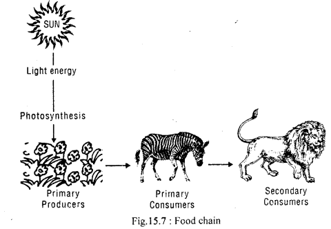
The food relation in its simplest form representing a producer, a primary consumer (herbivore), a secondary consumer (carnivore), and a decomposer is called a food chain. The next circle of such a food chain is called the food web.
Class 11 Geography Important Questions Chapter 15 Life on the Earth im-1

Question 9.
Describe various structural components of an ecosystem.
Answer:
Various structural components of an ecosystem are classified into two main groups:

  1. biotic or living, and
  2. abiotic or non-living.

The biotic component of an ecosystem comprises the kinds, numbers, and distribution of living organisms. The abiotic component consists of the kinds, quantity, and distribution of physical and chemical factors such as light, temperature, water, oxygen, carbon, nitrogen, and minerals.

Question 10.
Define ‘ecosystem’ with examples.
Answer:
The biotic community, along with the physical environment, forms an interacting system called the ecosystem. An ecosystem can be natural or artificial, temporary or permanent. A large grassland or a forest, a small tract in a forest or a single log, an edge of the pond, a village, an aquarium, or a manned spaceship can all be regarded as ecosystems.

Question 11.
Distinguish between biotic and abiotic factors.
Answer:
They are two components of an ecosystem. The biotic component comprises the kinds, numbers, and distribution of living organisms. The abiotic component, on the other hand, consists of the kinds, quantity, and distribution of physical and chemical factors such as light, temperature, water, oxygen, carbon, nitrogen, and minerals.

Question 12.
Explain with examples the role of members of the fungi kingdom of organisms.
Answer:
The fungi kingdom includes diverse kinds of multicellular heterotrophic organisms. There are over 100,000 species of fungi. Some are unicellular like yeast, others are complex like mushrooms. The fungi are the major decomposers and their activity is essential for the recycling of inorganic resources in the biosphere.

Question 13.
What do you understand by biogeochemical cycles?
Answer:
The balance of the chemical elements in the atmosphere and hydrosphere is maintained by a cyclic passage through the tissues of plants and animals. The cycle starts by absorbing chemical elements by the organism and returned back to air, water, and soil through decomposition. These cycles are energized by solar insolation. These cyclic movements of chemical elements of the biosphere between the organism and the environment are referred to as biogeochemical cycles.

Question 14.
What is the hydrologic cycle?
Answer:
All living organisms, the atmosphere, and the lithosphere maintain between them a circulation of water in solid, liquid, or gaseous form, referred to as water or hydrologic cycle.

Question 15.
What is denitrification?
Answer:
Herbivorous animals feeding on plants in turn consume some of it. Dead plants and animals, excreted nitrogenous wastes are converted into nitrites by the attachment of bacteria present in the soil. Some bacteria can even convert nitrites into nitrates that can be used again by the green plants. There are still other types of bacteria capable of converting nitrates into free nitrogen, a process known as denitrification.

Life on the Earth Important Extra Questions Long Answer Type

Question 1.
“Food chains are not isolated linear chains of trophic levels.” Comment.
Answer:
In nature, the food relationship cannot be explained only in terms of a single food chain. A herbivore consumes many types of plants or plant products. Many kinds of animals, other than tiger, derive food from herbivorous animals. Ticks and mites, leeches, and blood-sucking insects are dependent on herbivores and even on carnivores. Thus, food chains are not isolated linear chains of trophic levels.

Depending upon the availability and choice of food, different organisms at each level have a food relationship with more than one organism at the lower levels. A rat, for example, feeds on various kinds of stem, roots, fruits, and grains. In turn, it is consumed by a snake which is eaten by a falcon. The snakes feed on both, frogs and rats. Then, a network of food chains exist, which is called a food web. The food web becomes more complicated when taste and preference, availability, and compulsion are involved.

Question 2.
Describe the functions of various biotic components.
Answer:
Various biotic components include producers, herbivores, carnivores, and decomposers. All organisms require energy for their life processes. Food supplies both energy and materials for the sustenance of life. Green plants produce carbohydrates by photosynthesis and also synthesize proteins and fats. The green plants, therefore, are called producers. The animals that consume this energy are called consumers.

The herbivores like cattle, deer, and goats derive their food or energy directly from plants and are called the first-order consumers. The carnivores like tiger and lion depend on herbivores for their food and energy and are therefore called the secondary or second-order consumers. The non-green organisms like fungi and some bacteria, which do not produce their own food, live on the dead and decaying plants or animals and are consumers of a special type called decomposers.

Question 3.
Distinguish between Taiga and Tundra biome.
Answer:

Question 4.
Describe the energy flow in the biosphere.
Answer:
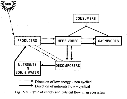
Energy from the sun enters the living world through photosynthetic organisms and passes on from one organism to another in the form of food.
Class 11 Geography Important Questions Chapter 15 Life on the Earth im-2
The organisms which trap solar energy and act as producers also use some energy for their own life processes. Only a portion of the energy trapped is taken by the primary consumers. Animals being more active than plants use much of the energy acquired before they are consumed by the next trophic level. At each stage of energy transfer, some amount of energy is lost from the food chain. The amount of energy transferred to the next higher level thus gradually decreases. The decomposition of dead organisms also releases chemical energy. Eventually, all this solar energy that entered the living system through the producers goes back into the non-living world, not as light but as heat.

Question 5.
Describe the carbon cycle in brief.
Answer:
Carbon is one of the basic elements of all living organisms. It forms the basic constituent of all organic compounds. The biosphere contains over half a million carbon compounds. The carbon cycle is mainly the conversion of carbon dioxide. This conversion is initiated by the fixation of carbon dioxide from the atmosphere through photosynthesis. Such conversion results in the production of carbohydrates, glucose that may be converted to other organic compounds such as starch, cellulose, etc. Here, some of the carbohydrates are utilized directly by the plant itself. During this process, more carbon dioxide is generated and is released through its leaves or roots during the day. The remaining unutilized carbohydrates become part of the plant tissue.

The plant tissues are either eaten by the herbivorous animals or get decomposed by micro-organisms. The herbivores convert some of the consumed carbohydrates into carbon dioxide for release into the air through respiration. The micro-organisms decompose the remaining carbohydrates after the animal dies. The carbohydrates that are decomposed get oxidized into carbon dioxide and are returned back to the atmosphere.

Movements of Ocean Water Class 11 Important Extra Questions Geography Chapter 14

Here we are providing Class 11 Geography Important Extra Questions and Answers Chapter 14 Movements of Ocean Water. Important Questions for Class 11 Geography are the best resource for students which helps in class 11 board exams.

Important Questions for Class 11 Geography Chapter 14 Movements of Ocean Water

Movements of Ocean Water Important Extra Questions Very Short Answer Type

Question 1.
What is inner space?
Answer:
The world of oceans and seas is referred to as “inner space,”

Question 2.
What are the important mechanisms by which ocean currents are generated?
Answer:
The important mechanisms are:

  1. The drag of winds over the ocean surface, and
  2. Unequal forces set up by differences in water density.

Question 3.
Classify the ocean currents.
Answer:
The ocean currents may broadly be classified into cold currents and warm currents.

Question 4.
Give the other name of tropical easterlies.
Answer:
Tropical easterlies are also known as trade winds.

Question 5.
Name the force that changes the direction of water drift in oceans.
Answer:
The Coriolis force changes the direction of water drift in oceans.

Question 6.
What kind of currents results due to differences in water density?
Answer:
Differences in water density set currents in a motion described as thermocline currents.

Question 7.
What is ‘gyre’?
Answer:
Due to the Coriolis effect, the moving water turns and follows an elliptical path and it is known as a gyre.

Question 8.
Which current flows as Kuroshio current after reaching the coasts of Taiwan and Japan?
Answer:
The North equatorial current flows as Kuroshio current after reaching the coasts of Taiwan and Japan.

Question 9.
Name the northern and southern branches of North Pacific current.
Answer:
Alaska and California currents respectively.

Question 10.
Define waves.
Answer:
Waves are oscillatory movements in water, where its particles move in a vertical plane, up and down.

Question 11.
What are the progressive waves?
Answer:
Ocean waves produced by winds are called progressive waves.

Question 12.
What is the difference between flood tide and ebb tide?
Answer:
Rise of sea level is called the flood tide and fall is called ebb tide.

Question 13.
Which is the birthplace of common eels?
Answer:
The Sargasso in the western North Atlantic is surrounded by the Florida current. It is often windless and is clocked with seaweed. It is the birthplace of common eels.

Question 14.
Up to what depth in water, the photosynthesis is possible for plants?
Answer:
The sunlight penetrates water up to 900 metres, but only in the top 100 metres is there enough light for plants to do photosynthesis.

Question 15.
When do the tides attain maximum height?
Answer:
Twice a month, when the earth, the moon and the sun are in a straight line.

Question 16.
At what interval of time do the tides occur on each meridian and why?
Answer:
Each meridian has a high and a low tide at an interval of 12 hrs. and 26 minutes, due to rotation of the earth.

Question 17.
Name two types of waves.
Answer:

  1. Transverse waves, and
  2. Longitudinal waves.

Question 18.
What is the main cause of the tide?
Answer:
The gravitational interaction of the earth, the moon and the sun is the main cause of tide.

Question 19.
What are the main processes of cooling of ocean water?
Answer:
Back radiation of heat from the sea surface, convection and evaporation.

Question 20.
What are ocean currents?
Answer:
The ocean currents are the regular movement of the surface of the water in a particular direction.

Question 21.
When does spring tide occur?
Answer:
Springtide occurs in the first and last quarter of the moon and sun are almost in a line.

Question 22.
Where does neap tide occur?
Answer:
When the sun and the moon are at right angles at the earth’s centre, neap tide occurs in the first and the last quarter of the moon.

Question 23.
What is the drift?
Answer:
The motion of the ocean water, generally at low velocity, as a result of surface friction from the prevailing winds.

Question 24.
What is salinity?
Answer:
It is the degree to which water contains dissolved salts.

Movements of Ocean Water Important Extra Questions Short Answer Type

Question 1.
Describe the types of ocean currents and their flow mechanism.
Answer:
Ocean currents are of two types: warm and cold currents. The main currents flow from the low latitudes in tropical zones towards high latitudes in the temperate and sub-polar zones. The cold currents flow from high latitudes to low latitudes.

Question 2.
Give reasons why the height of tidal waves varies from place to place?
Answer:
The height of the tidal waves varies from place to place because of the following reasons:

  1. The relative position of the moon and the sun with respect to the earth,
  2. Distribution of land and ocean on the earth’s surface, and
  3. Irregularities in the configuration of oceans.

Question 3.
What are tides?
Answer:
Tides are periodic rise and fall in the level of water in seas and oceans caused by the differential attraction of the moon and the sun. Twice a day, about every 12 hrs and 26 minutes, the sea level rises and falls. The rise of sea level is called the flood tide and the fall is called the ebb tide.

Question 4.
What is a tidal bore?
Answer:
‘The tidal waves follow the direction of the moon. In certain inland seas, where tidal waves reach from different directions, one can find a number of high tides and low tides. When such waves enter a gulf or river mouths, the tidal crests look like a vertical wall of water rushing upstream, which is known as the tidal bore.

Question 5.
Discuss the impact of prevailing winds on the motion of currents.
Answer:
Air flowing over the water surface exerts a dragging force upon that surface, setting the surface water layer in motion. Prevailing winds, such as the tropical easterlies (trade winds), blowing from east to west, and the middle-latitude westerlies, blowing from west to east, exert a one-way drag on sea surface over a vast expanse of oceans. This drag produces a system of drift currents.

Question 6.
Explain how differences in water density set currents in motion?
Answer:
Differences in water density can also set currents in motion These are described as thermocline currents. A surface water layer in one place may be less dense because it is warmer, or lower in density than the water layer in adjacent place that is colder or has a higher density. The water then moves gently from the region of less to the higher density.

Question 7.
Why the circulation of currents in the Indian ocean is different from the Atlantic and the Pacific oceans?
Answer:
The circulation of currents in the Indian ocean is characteristically different from the Atlantic and Pacific oceans because the Indian ocean is landlocked in the north. The circulation pattern in the northern portion of the Indian ocean changes its direction in response to the seasonal rhythm of the monsoons. There is a clear reversal of currents between winter and summer.

Question 8.
Describe the mechanism of origin of sea waves.
Answer:
It is commonly believed that the waves are generated due to friction on water surface caused by winds. The height of sea waves depends on:

  1. The wind speed,
  2. The duration of wind from a particular direction, and
  3. The fetch or the expanse of water surface over which the wind blows.

Question 9.
Distinguish between progressive and oscillatory waves.
Answer:
The ocean waves produced by winds rapidly through the water are called progressive waves, whereas in oscillatory waves each wave passes a fixed reference point, and the water particles travel through a vertical cycle of motion and return approximately to their original position.

Question 10.
Discuss the properties of waves.
Answer:
Waves are oscillatory movements in water, where its particles move in a vertical plane, up and down. The upper part of the wave is called the crest, and the lower part is called the trough. Each wave has a wavelength, velocity, height and wave period. The distance between two successive crests or two successive troughs is the wavelength. The time taken by a wavelength to pass a fixed point is known as the wave period. The vertical distance between a trough and a crest is called the wave height. The ratio of wavelength to the wave period gives the velocity of the wave.

Question 11.
Distinguish between Swell and Surf.
Answer:

SwellSurf
(1) Swells are the wind-generated waves in the

open sea.

(1) Surf also generated by winds but near the beach.
(2) They move in a uniform pattern of equivalent period and height.(2) This is foaming water which results from highly dynamic wave capacity.
(3) They are generated in the

open ocean

(3) These occur in the breaker zone of a shoreline.

Question 12.
What are the disadvantages of tides?
Answer:

  1. Tides are sometimes harmful to ships and boats.
  2. Tides check the formation of deltas.
  3. Marshes are formed due to accumulation of tidal water.
  4. Tides also hinder fishing.

Question 13.
Why does the temperature of seawater decrease with depth?
Answer:
The temperature of seawater is the same as that of the surface water up to a height of 100 metres. The surface of seawater receives, maximum insolation. As the rays penetrate the water, the heat is reduced by scattering, reflection and diffusion.

Question 14.
How can the velocity of the ocean currents be measured?
Answer:
The ocean currents flow like extensive rivers in the ocean. The rate of flow and the width of the currents, however, are not uniform. The Gulf stream, for example, is 80 km. wide and 1.6 km. deep. The Florida current has a velocity of 10 km. per hour on the surface and 3.5 km. at a depth of 200 m.

Movements of Ocean Water Important Extra Questions Long Answer Type

Question 1.
Write a short note on the vertical circulation of ocean water.
Answer:
Besides the horizontal movement, the vertical circulation of ocean water is also an important phenomenon. Ocean surface is marked with sinking and upwelling caused by wind action, evaporation of surface water, the addition of surface water by rainfall and changes in density due to cooling or warming of the surface layer. A most important cause of the sinking of ocean water on a large scale is cooling of the surface layer by loss of heat to the overlying atmosphere in high latitudes.

During long winters, much heat is lost to space than is gained by solar ^ radiation, thereby the relatively warm surface waters brought polewards v by ocean currents are drilled and increased in density. This water, generally close to the freezing point, sinks to the ocean floor, causing vertical circulation of the water.

Question 2.
Describe the currents of the Pacific ocean in brief.
Answer:
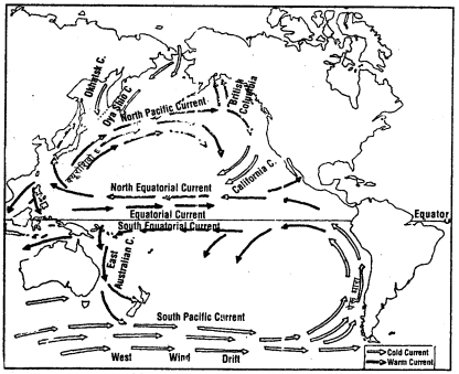
The important currents of the Pacific ocean are North equatorial, Kuroshio current, Alaska current, California current, Oyashio current, Okhotsk current, South equatorial current, South. Pacific current and Peru current.

The North equatorial current from the west coast of Central America reaches the Philippine Island, flowing from east to west in the north Pacific ocean.

Turning northward, the North equatorial current flows along Taiwan and Japan to form Kuroshio current. The currents are influenced by the westerlies from the south-east coast of Japan and tend to flow from west to east as North Pacific current. The current gets bifurcated into the northern and southern branches, called Alaska and California currents respectively after reaching the west coast of N&rth America.

The Alaska current flows anti-clockwise above the coast of British Columbia and Alaska, whereas the California current flows along the coast of California. The cold current, the Oyashio, flows in the North Pacific. Another cold current, named Okhotsk flows in the north Pacific and merges with Oyashio current, which finally sinks beneath the warmer waters of the Kuroshio.
Class 11 Geography Important Questions Chapter 14 Movements of Ocean Water im-1
Fig.14.3 current of the Pacific Ocean

The South equatorial current flows in the south Pacific ocean. It flows southward as the East Australian current before meeting the South Pacific current near Tasmania, which flows west to east. Near the south-western coast of South America, it turns north as the Peru Current. It is a cold current that feeds the South equatorial, thus completing the circle.

Question 3.
Distinguish between swash and backwash.
Answer:
When ocean waves arrive at the coast of a continent or island, they encounter shallow Water. The configuration of coast interferes with the progress of the waives. Waves in shallow water are modified into ellipses that become progressively flattered as the coast is approached, As the steeping waves continue to travel shoreward, encountering still shallower water, the crest height increases sharply and the forward slope of the wave becomes greatly steepened. At a critical point, the ‘ waveform disintegrates into a mass of turbulent water called the breaker. Thereafter, it becomes a landward moving sheet of highly turbulent water known as the swash or uprush.

The water then begins to pour seaward down the slope in a reverse flow termed as backwash or back rush. Thus, backwash is the seaward flow of a body of water down the slope after a wave has broken on the beach, in contrast to swash. It may also be called the drag of a recording wave.
Class 11 Geography Important Questions Chapter 14 Movements of Ocean Water im-2
Fig. 14.4: Longshore drift showing wave action and the movement of beach materials

Question 4.
Write a short note on a spring tide and neap tide.
Answer:
Tides are the periodic rise and fall in the level of water in seas and oceans caused by the differential attraction of the moon and the sun. Twice a day, about every 12 hrs and 26 minutes, the sea level rises and falls.

Tides do not rise to the same height every day. The relative position of the moon and the sun with respect to the earth is responsible for this variation in the height of tides. On the full moon and the new moon, the moon and the sun are almost in line with the earth, and hence, they exert their combined puli. Therefore, on these two days, tides are the highest and are known as spring tides.

On half-moon, the sun and the moon make a right angle at the earth’s centre. The pulls of the moon and the sun partly cancel each other out. as a result of which there are usually low tides called neap tides. This happens on the first and the last quarter of the lunar month when due to their right angular position to the attraction1 and centrifugal forces of the sun and the moon do not combine. This reduces the height of the tides to the minimum.
Class 11 Geography Important Questions Chapter 14 Movements of Ocean Water im-3

Question 5.
If there were no ocean currents, what would have happened to the world? Discuss.
Answer:
The oceans contain about 3% of the total water on earth. This water is always available for evaporation into the atmosphere and its subsequent precipitation on the land and the seas.

The general movement of a mass of ocean water in a fairly defined direction over great distances is called the ocean current. Current ranges in scale from ocean-wide flow system to local currents of small extent and can be generated by several mechanisms.’ Ocean currents are broad of two types: warm and cold currents. The warm currents flow from the low latitudes in tropical zones towards the high latitudes in the temperate and polar zones. The cold currents flow from high latitudes to low latitudes.

Water has an exceptionally great capacity for absorbing heat. The circulation of ocean water through currents helps in distribution of heat received in low latitudes to certain areas of high latitudes. In this way, the oceans modify the climate of the earth. Without ocean currents, this modification of climate would not have been possible.

The distribution of rich fishing grounds in the oceans and seas depends upon the circulation of water of the oceans as they bring nutrients to the surface in some areas. This process of bringing nutrients – both mineral and organic to the surface through the upwelling of water and its circulation is known as the ploughing action of the seas. Ocean currents aid in these processes. The absence of ocean currents would have hampered this process.

Ocean surface is marked with sinking (surges) and upwelling (swells) caused by wind action, evaporation of surface water, the addition of surface water by rainfall and changes in density due to cooling or warming of the surface layer. A most important cause of the sinking of ocean water on a large scale is cooling of the surface layer by loss of heat to the overlying atmosphere in high altitudes.

During long winters, much heat is lost to space, than is gained by solar radiation, thereby relatively warm surface waters brought poleward by ocean currents are chilled and increased in density. This water may be close to the freezing point and, therefore, sinks to the ocean floor. Without ocean currents, all the above activities of the ocean water would not have taken place.