Natural Hazards and Disasters Class 11 Important Extra Questions Geography Chapter 7

Here we are providing Class 11 Geography Important Extra Questions and Answers Chapter 7 Natural Hazards and Disasters. Important Questions for Class 11 Geography are the best resource for students which helps in class 11 board exams.

Important Questions for Class 11 Geography Chapter 7 Natural Hazards and Disasters

Natural Hazards and Disasters Important Extra Questions Very Short Answer Type

Question 1.
What do you mean by disaster?
Answer:
Disaster is a calamity, tragedy, or consequence of hazards.

Question 2.
Name some common natural hazards.
Answer:
Some common natural hazards are volcanic eruptions, earthquakes, droughts, floods, cyclones arid soil erosion.

Question 3.
What is a catastrophe?
Answer:
A sudden or widespread disaster is known as a catastrophe.

Question 4.
What are the causes of human-induced hazards?
Answer:
The human-induced hazards are caused by human activities such as a nuclear explosion, fire, industrial, etc.

Question 5.
What is the use of the Richter scale?
Answer:
It is used to measure the seismic energy radiated by an earthquake.

Question 6.
How are the earthquakes of non-tectonic origin caused?
Answer:
By volcanic eruptions, rock-bursts, subsidence in mines, impounding of reservoirs, etc.

Question 7.
Name the factors on which the intensity of storm waves of a cyclone depends?
Answer:
The intensity of storm waves depends on the wind, speed, pressure gradient, topography, and profile of the coastline.

Question 8.
How does flood occur?
Answer:
The flood occurs when a river overflows its banks and spreads out over the plains.

Question 9.
Which months experience the maximum number of storms in the Bay of Bengal and the Arabian Sea?
Answer:
October and November.

Question 10.
What is a flash flood?
Answer:
It is a sudden violent flood caused by exceptionally heavy rain in a normally dry valley in a semi-arid area.

Question 11.
What is the main cause of drought?
Answer:
The inadequate and uneven distribution of rainfall.

Question 12.
Identify two forms of landslides.
Answer:
Translational and rotational.

Question 13.
What does ‘MB’ stand for?
Answer:
Mb stands for millibar, the unit of measurement for pressure.

Question 14.
What are avalanches?
Answer:
A large mass of snow mixed with earth, stones, and ice loosened from a mountainside and drawn swiftly by gravity to the valley is called avalanches.

Question 15.
Which of the cyclones is more destructive?
Answer:
A tropical cyclone is more destructive.

Question 16.
Name three states which are affected by cyclones.
Answer:
Orissa, Andhra Pradesh, Tamil Nadu.

Question 17.
What is the velocity of a cyclone and its normal duration?
Answer:
20 km per hour.

Question 18.
To which theory the earthquake is related?
Answer:
Plate tectonics.

Question 19.
How much area in India is drought-prone?
Answer:
19%.

Question 20.
What is a landslide?
Answer:
It is the rapid sliding of large masses of bed rocks or regoliths.

Question 21.
What defines the Disaster Management Bill 2005?
Answer:
It defines a disaster as a catastrophe, mishap, calamity, or grave occurrence affecting any area arising from man-made causes.

Question 22.
Name the different types of droughts in India.
Answer:
Four types of droughts: Meteorological, Agricultural, Hydrological and Ecological droughts.

Question 23.
In India which state is flooded during winter?
Answer:
Tamil Nadu coast.

Question 24.
What is ‘storm surge’?
Answer:
The severe cyclonic storms with an average speed of 180 km/h result in a sudden rise in the sea level known as storm surge.

Question 25.
What type of disasters are caused by cyclones?
Answer:
Earthquakes, tsunamis, and volcanic eruptions,

Natural Hazards and Disasters Important Extra Questions Short Answer Type

Question 1.
What is an earthquake and what is its intensity?
Answer:
An earthquake is the sudden movement of the crust of the earth resulting in tremors and vibrations. Like magnitude, the intensity is also one of the ways to measure the strength of an earthquake. Intensity relates to the force of an earthquake. It is the measure of the damage caused by the earthquake.

Question 2.
Name a high and very high-risk seismic area of India.
Answer:
From the earthquake point of view, the high-risk areas are the Ganga plains and western Rajasthan, whereas the very high-risk areas are the Himalayan mountain, north-eastern India, Kachchh, west coast around Ratnagiri and Andaman and Nicobar islands.

Question 3.
What are the basic requirements for the formation of a cyclone?
Answer:
The following are the basic requirements for the formation of a cyclone:

  1. The temperature of the oceanic surface over 26°C.
  2. The appearance of a closed isobar.
  3. Pressure dropping below 1000 Mb.
  4. Areas of circular movement, first spreading to a radius of 30-50km., then increasing gradually to 100-200 km. and even to 1000 km.
  5. Verticallythewindspeedfirstrisingtoaheightof6km., then much higher.

Question 4.
What is the velocity of a cyclone and its normal duration?
Answer:
The speed of movement of a cyclone per unit of time is called its velocity. The cyclones move at an average velocity of about 20 km. per hour. Its normal duration is five to seven days.

Question 5.
Mention the flood-prone areas of India.
Answer:
The flood-prone areas of India include the Ganga basin covering Uttar Pradesh, Bihar, and West Bengal, the Brahmaputra basin in Assam, and the Baitarni, the Brahmani and Subarnrekha basins of Orissa.
Class 11 Geography Important Questions Chapter 7 Natural Hazards and Disasters
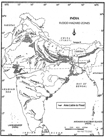
Fig.7.3 ‘Flood-prone areas of India’

Question 6.
Name two human activities that cause a flood in India.
Answer:
These are the two factors that increase the incidence of a flood.

  1. Deforestation,
  2. Drainage congestion (caused by the badly planned construction of bridges, roads, railway tracks, and other developmental activities).

Question 7.
What are the consequences of landslides on humans?
Answer:
There are the following consequences of landslides:

  1. Damage to planted vegetation and crops.
  2. Disruption of communication due to the blocking of roads and rivers.
  3. Destruction of human settlements over slopes and loss of human life.

Question 8.
What is disaster management?
Answer:
The term disaster management includes all aspects of prevention and protection measures, preparedness, and organization of relief operations for mitigating the impact of disasters on human beings and socio-economic aspects of the disaster-prone area.

Question 9.
How embankments worsen the problem of a flood?
Answer:
The construction of embankments, the river water spreads out the stream and flows oven, it worsens the problem of a flood. The width of the river stream becomes narrow and a flood occurs.

Question 10.
What are the major hazards that occur in India?
Answer:
Drought, floods, cyclones, landslides, and earthquakes are some of the major hazards which occur in India. These natural hazards or disasters are the results of sudden earth movements that change the face of the earth in a short period causing heavy loss of life and property.

Question 11.
What do you understand by ‘tsunami’?
Answer:
‘Tsunami’ is a series of waves generates under the body of water by an impulsive disturbance that vertically displaces the water column. Earthquakes, landslides, volcanic eruptions, and the impact of cosmic bodies like asteroids can generate a tsunami.

Question 12.
Define solifluction.
Answer:
Solifluction is the slow movement of rock debris, saturated with water and not confined to definite demands, down a slope under the force of gravity. It occurs particularly when thawing releases such surface deposits while the underlying layers are still frozen. The term is usually applied to saturated deposits.

Question 13.
Define pressure gradient.
Answer:
The amount of change in atmospheric pressure between two points is called the pressure gradient. It is indicated by the distance apart on a level surface of the isobar. Closely spaced isobars indicate a steep gradient and those widely spread represent gentle gradients.

Question 14.
Why north bank tributaries of the Brahmaputra river create more floods than those of the south bank?
Answer:
It is because the northern tributaries have steep slopes, shallow and braided channels, and coarse sandy beds; they carry a heavy silt charge and have a tendency to bring fresh floods. The south bank tributaries, on the other hand, have comparatively flatter gradients and deeper channels, they are clayey and have more stable banks and beds.

Natural Hazards and Disasters Important Extra Questions Long Answer Type

Question 1.
Discuss the three components of the impact phase of disaster management.
Answer:
The term disaster management includes all aspects of preventive and perspective measures, preparedness, and organization of relief operations for mitigation of the impact of the disaster on human beings and socio-economic aspects of the disaster-prone areas.-The whole process of disaster management can be divided into three phases, impact phase, rehabilitation and reconstruction phase, and integrated large term development and preparative phase.

The impact phase contains three components – forecasting of disaster, close monitoring of agents causing disasters, and management activities after the disaster has occurred. As far as forecasting of disaster is concerned, flood forecasting can be done by studying rainfall in the catchment area. The approach of cyclones can be tracked and monitored by satellites. Based on these details, early warning and evacuation efforts may be made.

Close monitoring of agents responsible for disaster can help the deployment of terms to help evacuation and supply of food clothing and drinking water. Disaster leaves a trail of death and destruction. This will require medical care and the help of the affected people. Under the long-term development phase, preventive and precautionary measures of various kinds should be chalked out.

Question 2.
What should people do and don’t do in an area going to be hit by a cyclone?
Answer:
In order to draw the attention of the people of the world, the UNESCO observed International Decade for natural disaster Reduction during 1990-2000. Along with other nations of the world, India observed World Disaster Reduction Day in October during the decade. Do’s and Don’ts for the people in cyclone-hit areas, which were issued by the Government of India are as follows:

  1. Listen to the radio for advance information and advice. Allow a considerable margin for safety.
  2. When the storm force winds or severe gales are forecast for your area: store or secure loose boards, corrugated iron, rubbish lines, or anything else that could become dangerous; tape up large windows to prevent them from shattering; and move to the nearest shelter or evacuate the area if this is ordered by the ‘ appropriate government agency.
  3. When the storm hits it is advisable: to stay indoors and take shelter in the strongest part of your house; listen to the radio and follow instructions; open windows on the sheltered side of the house if the roof begins to lift; find shelter if you are caught out in the open, and do not go outside during a lull in the storm.

Question 3.
Describe the flood in India as a disaster. Write an essay on floods as a disaster.
Answer:
Floods are a major cause of human misery in India every year. Out of a number of natural disasters that the country has experienced, floods are the most important ones. India is the most flood-affected country in the world next to Bangladesh. Twenty percent of the global deaths caused by floods in the world are in India.

In spite of the fact that floods are a natural disaster, it often turns out to be a social disaster as the people who are severely affected are generally the poor because they live on the periphery of the human habitat. The annual flood-affected population has arisen faster than the growth of India’s population. The flood-affected area and damages have also increased recently; the reason for this increase is the encroachment of flood plain by the people.

The most flood-prone basins in the country are those of the Ganga-in Uttar Pradesh, Bihar, and West Bengal, the Brahmaputra in Assam, and the Batumi, the Brahmani, and the Subarnrekha basins in Orissa. Sometimes floods occur also in Andhra Pradesh, Rajasthan, Haryana, and Gujarat.

Flood Control – Floods are not new in India. The practice of building flood protection embankments along rivers is an ancient one. We had flood protection embankments on the Godavari, Krishna, and the Kaveri deltas and in the Indo-Ganga plain.

The nationwide flood protection programs, however, began only after independence. At the time of independence in 1947, India had some 5280 km. of embankments along different rivers. Of this 3500 km. were in the Sundarbans in the West Bengal and 1209 km. along the Mahanadi in Orissa. This provided protection to about 3 million hectares of land.

In 1954 a spate of severe floods came. Enormous devastation was caused in Uttar Pradesh, Bihar, West Bengal, and Assam. Long term programs for the construction of dams and embankments were drawn. Central and state flood control boards were set up. In spite of various measures taken up to minimize the fury of floods, they are still a regular feature in the Ganga and the Brahmaputra basin.

Reducing Impact of Flood-The building of embankments was the only way floods could be controlled in the forties.
Class 11 Geography Important Questions Chapter 7 Natural Hazards and Disasters
Fig.7.3: “Heavily embankment areas of India’

The dams and reservoirs were considered useful to control runoff water and reduce flooding. Now there are several other measures to reduce the severity of the flood. The felling of trees and deforestation on mountain slopes and in catchment areas need control. Weather forecast and flood warning feature is a regular feature.

Question 4.
What is a tsunami? How it occurs and what are its consequences? Describe in detail.
Answer:
A tsunami is a series of waves generated in the body of water by an impulsive disturbance that vertically displaces the water column. Earthquakes, landslides, volcanic eruptions, and even the impact of cosmic bodies such as asteroids can generate a tsunami. When the Indian plate in the north-east gets locked with the Eurasian plate, it creates high stress, and the accumulation of high energy causes an earthquake.

Cause – Nomially the seismic waves cause only one instantaneous vertical wave but after the initial disturbance, a series of after waves are created in the water that oscillates between the high crest and low trough in order to restore the water level. The speed of waves in the ocean depends upon the depth of water. It is more in shallow water than at the ocean depth.

Consequences – The impact of the tsunami is less over the ocean and more near the coast where they cause large scale devastation. Therefore, a ship at sea is not much affected by tsunamis. The tsunami wave raises the ship only one meter because over deep water tsunami has a very long wavelength and limited wave height. Over shallow water, tsunami causes large-scale destruction along the shores, here wavelength gets reduced and height can be up to 15 meters.

  • After reaching the coast they release enormous energy and destroy the port cities and towns, structures, buildings, and other settlements.
  • The loss of property’ and life by the tsunami is much higher as compared to other natural hazards in the coastal areas.

Mitigation steps – It is difficult to mitigate the hazards caused by the tsunami because of the fact that losses are on a much large scale.

Question 5.
What is an earthquake? Discuss the causes and consequences of an earthquake.
Answer:
An earthquake is a sudden movement of the crust of the earth. An earthquake occurs when the Indian plate gets locked up with a Eurasian plate, high stress is developed which results in the release of high energy. It is a sudden shaking of the crust which results in tremors and vibrations.

Causes – The following are the causes of earthquakes:

  1. Volcanic eruption
  2. Tectonic causes
  3. Elasticity of rocks
  4. Local causes

Consequences –

  1. If the intensity of an earthquake is more than 6 on the Richter scale, there is a loss of life and property on a large scale.
  2. In the young fold mountains, the earthquake leads to cracks in the rocks and causes landslides.
  3. Due to earthquake, there are short circuits of electrical wires which damage and blast the equipment.
  4. Usually, earthquakes lead to distortion and displacement of the surface rocks which block the flow of the river coming in the ways.

Soils Class 11 Important Extra Questions Geography Chapter 6

Here we are providing Class 11 Geography Important Extra Questions and Answers Chapter 6 Soils. Important Questions for Class 11 Geography are the best resource for students which helps in class 11 board exams.

Important Questions for Class 11 Geography Chapter 6 Soils

Soils Important Extra Questions Very Short Answer Type

Question 1.
What is soil?
Answer:
Soil is a layer of unconsolidated material at the surface of the earth which has been derived from rocks and organic matter.

Question 2.
How is soil formed?
Answer:
It is formed by gradual disintegration under the influence of various agents.

Question 3.
Name the major factors in the formation of soils.
Answer:
Parent material, relief, climate, vegetation and drainage.

Question 4.
Name the three horizons of the soil.
Answer:

  1. A horizon – topmost
  2. B horizon – less leached
  3. C horizon – illuvial

Question 5.
Name the physical properties of the soil.
Answer:
Size, shape and arrangement of particles, the volume and effective depth of the soil.

Question 6.
What is ravine?
Answer:
It is a small narrow valley with steep sides. It is larger than a gully and smaller than a canyon.

Question 7.
Why soil conservation is important?
Answer:
Because it is the most important natural resource for plants, animals and human beings.

Question 8.
Define soil texture.
Answer:
Soil texture is the arrangement and relationship of particles of the soil.

Question 9.
What does the black colour of the soil indicate?
Answer:
It indicates the presence of rich organic matter in the soil.

Question 10.
What is meant by slight, moderate and severe erosion?
Answer:
If the soil erosion is less than 25% of the surface – light.

  • If it is between 25%-75% – moderate.
  • If it is more than 75% – severe.

Question 11.
Which organisms play an effective role in the fertility of the soil?
Answer:
These are bacteria, fungi, earthworms, ants and other insects and animals.

Question 12.
Which two groups the soils used to be classified into in ancient India?
Answer:
Urvara and Usara, meaning fertile and sterile respectively.

Question 13.
What does ICAR stand for?
Answer:
ICAR stands for Indian Council of Agricultural Research.

Question 14.
On which criteria, the ICAR classification is based?
Answer:
The ICAR classification is based on genesis, colour, composition and location.

Question 15.
Identify the various categories of soils in India as classified by ICAR.
Answer:
Alluvial soil, black soil, red and yellow soils, laterite soil, arid soils, saline soils, organic soil and forest soils.

Question 16.
What is Regur?
Answer:
‘Regur’ is black soil.

Question 17.
Which two types of soils have been developed in the upper and middle Ganga plain?
Answer:
Khadar and Bhangar. Khadar is a newer alluvial whereas Bhangar is older alluvial.

Question 18.
Give some examples of coarse grain.
Answer:
Jowar, Bajra, ragi, etc.

Question 19.
Which chemical is added to the soils in order to solve the problem of salinity?
Answer:
Gypsum is added to the soil in order to solve the problem of salinity.

Question 20.
What is ‘jumping’?
Answer:
‘Jumping’ is the name of shifting agriculture in India. This is the oldest type of agriculture. This is also known as ‘slash and bum’ method.

Question 21.
Which regions are known for cotton cultivation in India?
Answer:
The Deccan plateau and the Coimbatore upland are known for cotton cultivation in India.

Question 22.
Name the two most active agents of soil erosion.
Answer:
Wind and running water are the two active agents of soi 1 erosion.

Question 23.
What exhibits badland topography?
Answer:
Areas with poor vegetation and steep slope, particularly in undulating terrain and along with the river courses, often exhibit badland topography.

Question 24.
What are the ill effects of soil erosion?
Answer:
Ill effects of soil erosion are the removal of fertile soil, sudden and heavy floods, sitting of river beds, lowering of water bodies and lowering of the soil moisture.

Question 25.
Name three primary forms of soil structure.
Answer:
The three primary forms of soil structure are granular, blacky and peaty.

Question 26.
What are ferruginous gneiss and schist rocks?
Answer:
Time rocks containing iron are known as ferruginous gneiss and schist.

Question 27.
From which the black soil is derived?
Answer:

  1. Deccan trap and
  2. the ferruginous gneiss and schist rock.

Soils Important Extra Questions Short Answer Type

Question 1.
Explain how the soil organisms play an effective role in the fertility of the soil?
Answer:
A large number of soil organisms including bacteria, fungi, earthworms, ants, insects and animals play an effective role in the fertility of the soil. They multiply very quickly under favourable conditions and add nutrients to the soil.

Question 2.
How did the soils use to be classified in ancient India?
Answer:
In ancient India, the soils used to be classified into two main groups, viz., Urvara which were fertile and Usara which were sterile. The Urvara soils were subdivided into different types on the basis of crops grown, such as barley soil, rice soils, etc. Similarly, Usara soils were sub-divided into salt land, deserts, etc.

Question 3.
Discuss the types and characteristics of alluvial soils.
Answer:
Alluvial soils are depositional soils transported by the streams and winds. They are largely sandy loam in texture. The colour of the alluvial soils varies from light grey to ash grey. Its shades depend on the depth of the deposition, the texture of the materials, and the time taken for its formation.

Question 4.
What are ravines? How are they different from gullies?
Answer:
A ravine is a small, narrow valley with steep sides, larger than a gully, but smaller than a canyon.

A gully, on the other hand, is a narrow channel worn in the earth by water. It is especially a miniature valley resulting from a heavy downpour of rain. Further erosion and deepening of a gully leading to the formation of a ravine.

Question 5.
Differentiate among soil erosion, soil exhaustion and soil degradation.
Answer:
The removal of the soil by running water in wet areas and wind in dry areas is known as soil erosion. The removal of its organic and mineral content is referred to as soil exhaustion. Whereas the misuse of the soils leads to soil degradation i.e. decline in the quality of soil, However, the agencies involved in soil erosion, exhaustion and degradation are common. They are running water, wind, snow, animals and human beings.

Question 6.
Which elements are required by plants as nutrients?
Answer:
A large number of elements namely, carbon, hydrogen, oxygen, nitrogen, phosphorus, potassium, sulphur, magnesium, calcium, iron, manganese, zinc, copper, boron and molybdenum are required by a plant as nutrients.

Question 7.
Classify the soil on the basis of various types of water in India.
Answer:
There are four types of soils identified on the basis of different types of water. They are Barani, Chari, Nahari and sailable. Soils dependent on rainwater are called Barani, that on well irrigation Chari, that on canal irrigation Nahari and that on river percolation sailable.

Question 8.
Define alluvium.
Answer:
The alluvium is the unconsolidated, loose material left only soil but also the gravel and sand brought down by a river and deposited in its bed, flood plain, delta or estuary, or in a lake, or land down like cone deposits on the flood plains of the large rivers.

Question 9.
Which type of soil is derived from Deccan lavas? Explain its important characteristics?
Answer:
Black soil is derived from Deccan lavas. The important characteristics are:

  1. It chemically consists of lime, iron, magnesia and alumina.
  2. It is generally clayey, deep and impermeable.

It lacks in phosphorous, nitrogen and organic matter but contains potash.

Question 10.
Which type of soil is the most dominant type and where is it found? Describe its two properties.
Answer:
Alluvial soils are the most widespread soil covering an area of 8 lakh sq. km. from Punjab to Assam. It is found over about 43.7% area in India. It is found in river basins, flood plains and coastal areas. This soil is rich in potash but poor in nitrogen. Alluvial soi Is are of three types:

  1. Khadar soils -f fine and deposited in flood plains.
  2. Bangar soils – older alluvium soil.
  3. Newest alluvial soils – fine alluvial soil found in delta.

Question 11.
What are the characteristics of laterite soils?
Answer:

  1. The laterite soils are brick coloured.
  2. These are shallow, acidic and less fertile.
  3. these less fertile due to leaching of soil.
  4. These are poor in nitrogen, potash but rich in iron. This is found in Tamil Nadu.

Question 12.
What is the parent material of soil?
Answer:
The soils are formed due to the weathering and erosion of rocks exposed on the surface. The material which has undergone weathering and erosion and had contributed to soil formation is known as the parent material. The type and nature of parent materials play a vital role in determining the properties of soil.

Question 13.
What is contour ploughing?
Answer:
The method of tilting or ploughing hillsides or sloping lands among the contour lines, that is, around rather than up and down a slope mainly with a view of conserving soil and water.

Question 14.
How can we improve the fertility of soils?
Answer:
The fertility of the soil means the presence of humus contents and enough soil nutrients which provides nourishment to the plants. To improve the fertility of the soil following methods should be used:

Question 15.
Distinguish between soil erosion and soil conservation.
Answer:

Soil erosionSoil conservation
(1) Ills black in colour and hence called black soil.(1) It is yellow in colour.
(2) It is formed by the decomposition of lava.(2) It is formed by leaching in tropical areas.
(3) It is suitable for the cultivation of cotton.(3) It is suitable for millets.
(4) Et is found in Deccan plateau.(4) It is found over a low plateau in Bihar.

Soils Important Extra Questions Long Answer Type

Question 1.
Describe the areas affected by soil erosion. What are the factors responsible for it? Suggest measures to conserve it.
Answer:
The areas affected by the soil erosion are West Bengal, Uttar Pradesh, Madhya Pradesh, Maharashtra, Tamil Nadu, Karnataka, Delhi, Rajasthan and many other parts of India.

  1. Potato cultivation in theregionofMeghalayaonNilgiri hills causes soil erosion.
  2. Cleaning of forests in the Himalayas and on the Western Ghats.
  3. Excessivegrazingbycattleontheslopesofhillscauserapidsoil erosion.
  4. On steep slopes due to running water soil-erosion increases.
  5. Strong winds cause soil erosion. They blow away soil in dry areas.
  6. Heavy rainfall causes soil-erosion.
  7. Jumping by the tribal population in different parts of the country have caused considerable depletion of the soils.
  8. Deforestation causes soil erosion.

The followings are the measures to conserve the soils:

  1. By scientific use of land.
  2. Crop-rotation, contour ploughing and bunding.
  3. Afforestation in the upper reaches of river basins.
  4. Increased use of organic manures.
  5. Construction of water barriers against gullies in wet regions.
  6. Replacing flood irrigation by sprinklers and drip irrigation.

Question 2.
Write a short note on Arid soils and Saline soils.
Answer:
Arid soils – Arid soi 1 is red to brown in colour. They are generally sandy and alkaline. In some areas, the salt content is so high that common salt is obtained by evaporating the saline water. In a dry climate, due to high temperature and accelerated evaporation. They lack moisture and humus content is normal. Lower horizons of soils are occupied by Kankar due to increased calcium downward. This type of soil is found in Rajasthan where desert topography is found. These soils contain less humus and. organic matter. These are suitable for Jowar, Bajra, Ragi and oilseeds, etc.

Saline soils – These are known as Usara soils. It contains a larger portion of sodium, potassium and magnesium. It is poorly fertile. These require more salts largely because of the dry climate and poor drainage. These are found in arid and semi-arid regions and water-logged and swampy areas. Its structure ranges from sandy to loamy. It lacks nitrogen and calcium. Saline soils are found in the region of western Gujarat, deltas of the eastern coasts and Sunderban area of West Bengal. With the excessive use of cultivation and irrigation, the fertile alluvial soils are becoming saline.

Question 3.
Describe the major characteristics and distribution of the soils in India.
Answer:
Characteristics and distribution of soils in India:
1. Alluvial soil – It is fine silt deposited in the plains by rivers, brought from the mountain regions. It is very fertile and famous for agriculture. Relatively fine and new soil of the flood plains and deltas is known as Khadar and older deposits as Bangar. Great plains of the north and deltas of peninsular rivers abound in alluvial soil.

2. Black soil – Black soil is made of volcanic rocks of lava flows. The soil is fertile and clayey. It can maintain moisture for long periods. Due to black in colour, it is said to be black soil. Cotton is grown abundantly in this soil. Locally it is named as regur soil. Gujarat, parts of M.P. and Maharashtra have black soil over large areas.

3. Red soil – Red soil has developed on the crystalline igneous rocks. They are less fertile but with the help of manures and fertilisers, good crops are raised in it. Relatively hot and dry parts of southern and eastern peninsula abound in red soils.

4. Laterite soil – Due to heavy rains fertile portion of the soil has been washed away leading to leaching. Hence the soil is infertile. Hilly regions of Western Ghats and Chhotanagpur plateau with heavy rainfall and hot weather are represented by this type of soil.

5. Mountain soils are found in the Himalayan region. They are good for tea growing. Desert soil is found in Rajasthan. They are sandy and do not produce any significant crop.

Question 4.
Discuss the type of physical conditions leading to the formation of peaty and organic soils.
Answer:
The peaty and organic soils are found in the areas of heavy rainfall and high humidity, where there is a good growth of vegetation. A large amount of dead organic matter accumulates in these areas and this gives rich humus and organic content to the soil. Hence, they are peaty and organic soils. Organic matter in these soils may go even up to 40 to 50%.

These soils are normally heavy and black in colour. They occur widely in the northern part of Bihar, the southern part of Uttaranchal and coastal areas of West Bengal, Orissa and Tamil Nadu. Such soils are used for cultivation of high and less soil exhaustive crops.

Question 5.
(a) So long a balance exists between the processes of soils formation and soil erosion, there is no nutrient, but when the balance has distributed the erosion of the soil becomes a menace. Comment.
Answer:
The removal of soil by running water and the erosion process of running water and wind are continuous. Generally, there is a balance between these two processes. The rate of removal of fine particles from the surface is the same as the rate of addition of particles to the soil layer. Sometimes such a balance is distributed by natural or human factors, leading to a greater rate of removal of soil. When this happens, the entire soil layer may be removed in a few years.
Indiscriminate felling of trees, careless overgrazing of pasture lands, unscientific drainage operations and improper land use are some of the important causes which upset this balance.

(b) What are ravines? How are they different from gullies?
Answer:
Ravines: A ravine is a small narrow valley with steep sides, larger than a gully, but smaller than a canyon.

A gully, on the other hand, is a narrow channel worn in the earth by water. It is especially a miniature valley resulting from a heavy downpour of rain. Further erosion and deepening of a gully leading to the formation of a ravine.

Natural Vegetation Class 11 Important Extra Questions Geography Chapter 5

Here we are providing Class 11 Geography Important Extra Questions and Answers Chapter 5 Natural Vegetation. Important Questions for Class 11 Geography are the best resource for students which helps in class 11 board exams.

Important Questions for Class 11 Geography Chapter 5 Natural Vegetation

Natural Vegetation Important Extra Questions Short Answer Type

Question 1.
What is natural vegetation?
Answer:
Natural vegetation means a plant community that has been left undisturbed over a long period of time, so as to allow its species to adjust themselves to climate and soil conditions as fully as possible. Natural vegetation is found in mountain regions,

Question 2.
How many types the natural vegetation in India can be classified into?
Answer:
Based on the structure, physiognomy and florists nature of the | plants, the natural vegetation in India can be divided into:

  1. Tropical evergreen forests
  2. Tropical dry deciduous and evergreen forests
  3. Semi-desert and desert vegetation
  4. Wetlands littoral and swamp forests
  5. Montane vegetation
  6. The grasses

Question 3.
What is boreal?
Answer:
The species which are brought from outside are known as exotic and about 40% of the plant species in India are found to be exotic. The plant species which are brought from the Sino-Tibetan area are known as ‘boreal’.

Question 4.
Describe the vegetation in central parts of the plateau.
Answer:
In the central part of the Indian plateau dry tropical or deciduous
and thorny vegetation is found. This region receives less than 70 cm. rainfall and is covered with thorn forest type of vegetation. This part! presents vast undulating poor grassland. Summer is very long and dry,
the landscape changes to the pale carpet of grasses with grey stone surfaces.

Question 5.
Give any three characteristic features of tropical deciduous forests.
Answer:

  1. TheyarefoundonfoothillsofHimalayasandmanyparts of peninsular plateau.
  2. During the dry season, they shed their leaves. Teak, Shisham, sal, rosewood are the main species.
  3. They have important economical significance.

Question 6.
What do you mean by biosphere reserve? Where and when was the first biosphere reserve of India developed?
Answer:
The vast areas which have been reserved for the preservation and protection of flora and fauna of the country in their natural form are known as bio-reserves. In these areas, the plants and animals are kept to protect for the future generation. The first Biosphere in India was developed at Nilgiri.

Question 7.
Describe the location and characteristic features of Kaziranga National Park.
Answer:
Kaziranga National Park is located inNagaonandGolaghatdistricts on the southern bank of Brahmaputra river at the foot of Mikir hills. It lies in the flood plains of the Brahmaputra river. The riverine habitat consists primarily of tall, dense grasslands interspersed with open forests. One homed rhinoceros and elephants are the main inhabitants of this park.

Question 8.
Write a short note on Sundarbans Biosphere Reserve.
Answer:
It is located in the swampy delta of the two great Indian rivers the Brahmaputra and the Ganga in West Bengal. It extends over a vast area of mangrove forest, swamps and forested islands, covering over 1300 sq. km. Sunderban is the home of nearly 200 Royal Bengal Tigers. Adapting themself to the saline and freshwater environment, the tigers at the park are good swimmers.

Question 9.
How can we utilise our forests resources for the future? Give three methods.
Answer:

  1. We have to stop the reckless cutting of forests.
  2. To reduce the pressure on forests, the substituent of timber should be found out.
  3. To fulfil the basic needs of fuel and fodder of the people, social forestry and farmer forestry should be introduced.
  4. More and more trees should be planted.

Question 10.
Name the various Bio-reserves in India.
Answer:

  1. Nilgiri (Karnataka)
  2. Nanda Devi (Uttranchal)
  3. No Krek (Meghalaya)
  4. Andaman Nicobar
  5. Valley of flowers (Uttranchal)
  6. Gulf of Mannar (Tamil Nadu)
  7. Rann of Kutchh (Gujarat)
  8. Kaziranga National Park (Assam)

Question 11.
What are the characteristic features of the tropical evergreen forests?
Answer:

  1. There is a dense growth of vegetation which causes difficulty. of accessibility. A number of species are very large.
  2. There is a lack of pure stands.
  3. High temperature and heavy rainfall make conditions unsuitable for living.

Question 12.
What is the difference between National parks and Sanctuaries?
Answer:

National parksSanctuaries
(1) This is an area of multi ecosystems.(1) The area of wildlife sanctuaries are also dedicated to protecting wildlife and species.
(2) This area has not been materially altered by human occu¬pation.(2) There is no entry without permission.
(3) This is dedicated to protecting wildlife.(3) Hunting and grazing are prohibited.
(4) Plant and animal species, for scientific education, recreation and geomorphological sites are present.(4) Man’s activity is allowed in the sanctuaries.

Question 13.
How vegetation is different from forests?
Answer:
Vegetation is not limited to forests only. It is something more than the forests. Vegetation includes trees, grasses, shrubs, etc. Vegetation gives a distinct type of landscape to the region as grassland, woodland.

Forests are all type of vegetation. It refers to the society of trees in close growth. Forests are very useful for mankind.

Question 14.
Define reafforestation and afforestation.
Answer:
Reafforestation is the saplings of two plants which are planted to replace every felled tree. It is practised to avoid the evils of Jumping.

Afforestation is the planting of one sapling to get one tree. It is practised to bring more area under forest.

Natural Vegetation Important Extra Questions Long Answer Type

Question 1.
Why have certain species of animals become extinct in our country? What is being done to preserve wildlife?
Answer:
Wildlife has a very important role for mankind. But we have depleted its habitat, the forests, very fast. We have hunted wild animals and poached them indiscriminately. The result is that many of these wild animals face the danger of extinction. The major animals which face extinction are antelopes, lion, tigers, blackbuck, bustard, etc. Hence, to see the future need, there is an urgent need to conserve them.

Steps to be taken to preserve wild-life:

  1. Hunting and poaching of wild animals have been banned.
  2. Strict and severe punishment is accorded to defaulters.
  3. National parks, zoos, sanctuaries and biosphere reserves have been set up more and more in number all over the country.
  4. Maintenance of the existing trees.
  5. More and more birds and animals are being declared national birds and animals.
  6. ‘Project Tiger’ and ‘Project Elephant’ programmes have been ‘ launched to preserve and conserve wildlife.

Question 2.
Describe the various regions of concentration of forests in varying degrees in India.
Answer:
On the basis of the percentage of the actual forest cover, the states have been grouped into four regions. They are:

  1. The region of high concentration
  2. The region of medium concentration
  3. The region of low concentration
  4. The region of very low concentration

1. The region of the high concentration-This region includes the states where the percentage cover of the forest is more than 40%. All the eastern states except Assam fall in this category. Favourable climate, especially rainfall and temperature, is responsible for the high concentration of forests. There is variation in forest cover in the region. In the states of Mizoram, Nagaland and Arunachal Pradesh and in the Union Territory of Andaman and Nicobar Islands, forests occupy more than 80% of the geographical area. Manipur Meghalaya, Tripura, Sikkim and Dadra and Nagar Haveli have a percentage of forest between 40 and 80.

2. The region of moderate concentration – It includes the states of Madhya Pradesh, Orissa, Goa, Kerala, Assam and Himachal Pradesh. Goa has the lightest (33.79)% of the actual forest followed by Orissa and Assam. Rest of the states have less than 30% of their area.

3. The region of low concentration – This region is also not continuous. The states of Maharashtra, Karnataka, Andhra Pradesh and Tamil Nadu form peninsular sub-region while those of Uttar Pradesh and Bihar form the northern sub-region.

4. The region of very low concentration – The northwestern part of India falls in this category. The states included are Rajasthan, Punjab, Haryana, Gujarat, Chandigarh and Delhi. West Bengal in the east also comes under this region. Physical and human factors have been responsible for a very low concentration of forests in these areas.

Question 3.
Write a short note on the strange creatures of India.
Answer:
The strange creatures of India are Gangetic dolphin, Civets, Indian Pangolin, GreatlndianHorbill, Indian giant squirrel, mouse, deer and flying-fox.

Gangetic Dolphin – It lives in the Ganga river. It is born blind and lives sightless for the rest of its life.

Civets- It is a cat I like creature, lives solitary, comes out at night to hunt small birds, mammals and reptiles. It remains hiding during the day.

Indian pangolin – It has a scaly body. As protection against predators, it rolls itself into a ball and raises its sharp scales.

Great Indian Hornbill – It is a large bird with strange nesting habits; the female seal herself into d hollow in a tree and the male dutifully brings her food during the entire period of incubation.

Indian giant squirrel – It is a large nocturnal rodent which lives in the upper canopy of trees. It flaps between its body and its extremities act like parachutes and enable the large mammal to glide from tree to tree.

Mouse deer-This is a deer of 30 cm. in height. To evade predators, it hides beneath the low bushes and vegetation.

Flying fox – It is one of the world’s largest bats and is found all over India. Its wingspan is more than 1.5 m. and can fly over 220 km.

Question 4.
What is a Biosphere reserve? How many Biospheres are found in India? Describe in short.
Answer:
A Biosphere Reserve is a unique and representative ecosystem of terrestrial and coastal areas which are internationally recognized within the framework of UNESCO’S Man and Biosphere Programme.

There are 4 biosphere reserves in India. Four biosphere reserves namely

  1. Nilgiri,
  2. Nanda Devi,
  3. Sunderbans,
  4. Gulf of Mannar has been recognised by UNESCO on world network.

1. Nilgiri Biosphere Reserve- It is the first of the fourteen biosphere reserves of India and was established in September 1986. The total area of the biosphere reserve is around 5520 sq. km. Nilgiri Biosphere Reserve possesses different habitat types, unspoilt areas of natural vegetation types with several dry and moist deciduous, semi-evergreen and wet evergreen forests, evergreen sholes, grasslands and swamps. It includes the largest known population of two endangered animal species, namely the Nilgiri Tahr and the Lion-tailed Macaque. About 80% of the flowering plants reported from the Western Ghats occur in the Nilgiri Biosphere Reserve.

2. Nanda Devi Biosphere Reserve – It is situated in Uttranchal, includes parts of Chamoli, Almora, Pithoragarh and Bageshwar districts. The major type of the reserve is temperate forest. A few important species are silverweed, orchids, Latifolie and rhododendron. The biosphere reserve has a rich fauna, for example, snow leopard, black bear, brown bear, musk deer, snow-cock, golden eagle.

3. Sundarban Biosphere Reserve – This reserve is located in the swampy delta of the river Ganga in West Bengal. It spreads over a vast area of 9,630 sq. km and consists of mangrove forests, swamps and s- forested islands. It is a home of nearly 200 Royal Bengal Tigers.

4. Gulf of Mannar Biosphere Reserve – It covers an area of 1,05,000 hectares on the south-east coast of India from Sri-Lanka. The biosphere reserve comprises 21 islands with estuaries, beaches, forests of the nearshore environment, seagrass, coral reefs and mangroves.

Question 5.
Describe the importance of social forestry in India.
Answer:
The social forestry was used for the first time by the National Commission on Agriculture in 1976 to denote tree raising programmes to supply firewood, small hunters and minor forest produce to the rural population. Ambitious social forestry programmes have been launched by several state governments. The forest departments in most states have set up separate social forestry wings.

Social forestry programmes have mainly three components viz., farm forestry, wood lots and community wood lots. Farm forestry encourages farmers to plant trees on their own farmer; wood lots are planted by the forest departments for the needs of the community especially along roadsides, canal banks and other such public lands, and community wood lots are planted by the community themselves on community lands, to be shared equally by them.

Climate Class 11 Important Extra Questions Geography Chapter 4

Here we are providing Class 11 Geography Important Extra Questions and Answers Chapter 4 Climate. Important Questions for Class 11 Geography are the best resource for students which helps in class 11 board exams.

Important Questions for Class 11 Geography Chapter 4 Climate

Climate Important Extra Questions Very Short Answer Type

Question 1.
Name the upper-level velocity winds blowing up to a height of 12 to 16 km. within the troposphere.
Answer:
Jet streams.

Question 2.
Name the most common form of tropical storms.
Answer:
Thunderstorms.

Question 3.
What is the local name of thunderstorms in West Bengal?
Answer:
Kalbaishakhi.

Question 4.
The average annual rainfall in India.
Answer:
125 cm.

Question 5.
Which is the coldest place in India?
Answer:
The coldest place in India is Drass(Kargil). Here the temperature drops upto-45°C.

Question 6.
Name the hottest place in India.
Answer:
The Barmer (50°C) is the hottest place in Rajasthan.

Question 7.
Name the coastal states affected by tropical cyclones.
Answer:
Tamil Nadu, Andhra Pradesh, West Bengal and Orissa.

Question 8.
What causes winter rainfall in south-east coast?
Answer:
North-east monsoon causes winter rainfall in south-east coast.

Question 9.
In which part of India retreating monsoon causes rainfall?
Answer:
Over the Coromandel coast.

Question 10.
What is October heat?
Answer:
The oppressive weather due to high temperature and high humidity is known as October heat.

Question 11.
What is the local name of a thunderstorm in Assam and Bengal?
Answer:
Assam-Bordoi chilla, Bengal – Kalbaishakhi.

Question 12.
What type of climate is found in India?
Answer:
Tropical monsoon type climate.

Question 13.
Name the two factors which affect the Indian monsoon.
Answer:
Pressure difference and the jet stream.

Question 14.
Name two main seasons of the Indian climate.
Answer:

  1. South-west monsoon season.
  2. North-east monsoon season.

Question 15.
Where do you find the polar type of climate in India?
Answer:
In Jammu and Kashmir.

Question 16.
Name a long spell of abnormally hot weather.
Answer:
Heatwave.

Question 17.
Which are the two places which receive the highest rainfall in India?
Answer:
Mawsynram and Cherrapunji.

Question 18.
What are the two factors which are considered to be decisive in all the schemes of climatic classification?
Answer:
Temperature, rainfall.

Question 19.
The criterion of classification on the basis of Thornthwaite’s scheme.
Answer:
The Thomthwaite’s classification is based on the criterion of moisture index.

Question 20.
From which part of the India monsoon enters?
Answer:

  1. the Arabian Sea,
  2. The Bay of Bengal.

Question 21.
What is ITCZ?
Answer:
The ITCZ means Inter-Tropical Convergence Zone.

Question 22.
Which major tropic India lies across?
Answer:
Tropic of Cancer (23!/2°N latitude).

Question 23.
When there is cold weather in India, in which part the sun shines vertically?
Answer:
The sun shines vertically over the Tropic of Caricom (23 1/2°S).

Question 24.
When does the south-west monsoon start retreating?
Answer:
At the end of September.

Question 25.
What is the base of Koeppen’s scheme of climatic classification?
Answer:
Koeppen’s classification is based on monthly values of temperature and precipitation.

Climate Important Extra Questions Short Answer Type

Question 1.
Identify the four seasons based on Indian meteorology.
Answer:
In India the year is divided into four seasons based on Indian meteorology.

  1. The cold weather season – begins from December to February.
  2. The hot weather season – begins from March to May.
  3. The south-west monsoon season – begins from June to September.
  4. Theretreatingmonsoon season-beginsfromOctobertoNovember.

Question 2.
What are the coldest parts of India?
Answer:
The coldest parts of India are the trans-Himalayan regions. Jammu Kashmir and Himachal Pradesh are the coldest states of India. The minimum temperature drops up to -40°C at Drass. These regions get snowfall during winter and temperature remains below freezing point.

Question 3.
What do you mean by ‘breaks’ in monsoon?
Answer:
When the highly charged winds blow in south-west direction on the west coast, it advances rapidly over the west coast. The rain begins suddenly in the first week of June. The sudden onset of rain is termed as monsoon burst. The rainfall is heavily accompanied by thunder and lightning and appears as if a balloon of water has been burst. The sudden onset of monsoon is known as burst or breaking of monsoon.

Question 4.
What are the characteristics of western disturbances of the Indian climate?
Answer:

  1. The cyclones developed near the Mediterranean Sea are termed as western disturbances.
  2. They move towards India through Iran and Pakistan.
  3. They come under the influence of westerly jet stream which. brings them to the northern part of India in the winter season.
  4. They cause rain in the north-west part of the plain of India.

Question 5.
What do you mean by ‘Loo’?
Answer:
‘Loo’ is a hot and dry wind which blows from the west in the months of May and June in the northern part of India. It causes an increase in day temperature between 45°C and 50°C. It causes a harmful effect on the human body.

Question 6.
Name the four months in which India receives high rainfall and why.
Answer:
India receives the bulk of rainfall in the months of June, July, August and September known as the rainy season.

It is because of the south-west monsoon winds, which are onshore during this period and easterly jet streams stress the tropical cyclone to India which causes heavy rainfall.

Question 7.
Mention the formula used for calculation of the variability of rainfall.
Answer:
The variability of rainfall is given by the formula Standard Deviation
Class 11 Geography Important Questions Chapter 4 Climate im-1
where C is known as the coefficient of variation.

Question 8.
Why Tamil Nadu gets more rain in winter than in summer?
Answer:
Because Tamil Nadu lies on the Coromandel Coast on the eastern coastal plain. In summer, Tamil Nadu remains dry. But in winter, north-east monsoon picks up moisture and crosses the Bay of Bengal. These retreating monsoons are onshore winds causing rainfall in this area.

Question 9.
Why Mawsynram and Cherrapunji get very high rainfall?
Answer:
Mawsynram receives the highest amount of rainfall in the world in the rainy season because it is surrounded by the North-east hills of India, mainly Khasi, Garo, Jaintia in Meghalaya plateau is funnel-shaped. The Bay of Bengal branch of the south-west monsoon is enclosed by these hills resulting in the heaviest amount of rains.

Question 10.
Give the main characteristics of the monsoons rains.
Answer:

  1. The beginning of the rains is sometimes delayed over the whole or a part of the country.
  2. There are prolonged breaks of rains in July or August.
  3. Sometimes the rain ends earlier than usual time causing great damage to standing crops.
  4. The summer rainfall comes in heavy, leading to soil erosion.

Question 11.
What do you understand by ‘Mango showers’?
Answer:
‘Mango showers’ are actually premonsoon showers experienced towards the summer monsoon. It is common in Kerala and coastal areas of Karnataka in March and April. It helps in the ripening of mangoes. Therefore, locally it is known as Mango-showers.

Question 12.
What is the average amount of rainfall over the plains of India?
Answer:
The plain is divided into three zones to study the average rainfall.

  1. TheplainsofBihar, BengalandeastemU.P.-rainfall is 100-200cm.
  2. The plains of central and western U.P. – rainfall is 60-100 cm.
  3. Plains of Haryana, Punjab – rainfall is 40-60 cm. annually.

Climate Important Extra Questions Long Answer Type

Question 1.
What is the Inter-Tropical Convergence Zone (ITCZ)? How does it attract south monsoon? What are the important factors which influence the mechanism of Indian weather?
Answer:
ITCZ is the zone near the equator from where the north-east trade winds and the south-east trade winds meet each other. It changes its position with the effect of the vertical rays of the sun. It is near the Tropic of Cancer in the north in summer season and near the Tropic of Capricorn in the south in the winter season at about 25°N, as a result of which the south-east trade winds cross over the equator and enter in India as the south-west monsoon.

Factors influencing the mechanism of Indian weather-

  1. Surface distribution of pressure and winds include monsoon, location of low and high pressure.
  2. Upper air circulation which includes global weather conditions like air masses and the jet stream.
  3. Atmospheric disturbances like western cyclones and tropical cyclones cause rainfall.
    These are the factors which affect the Indian weather.

Question 2.
Rainfall in India is orographic in nature. Describe the distribution of rainfall and the effect of relief on its distribution.
Answer:
The orographic nature of rainfall plays an important role in the distribution of rainfall in India. The rainfall is determined by the situation of the mountains. In India, it is called relief rainfall. It affects the distribution of rainfall in the following manner:

  1. Western-coastal plains receive heavy rainfall due to the Western Ghats, more than 300 cm. but Deccan plateau that lies in the rain shadow area receives only 60 cm. rainfall.
  2. Low rainfall in the rain shadow area of the Western Ghats (less than 60 cm.).
  3. Due to funnel-shaped hills, heavy rainfall in Meghalaya (more than 1000 cm.).
  4. Low rainfall in Rajasthan due to the direction of the Aravali range. It lies parallel to the south-west monsoon winds. So, Rajasthan remains dry.
  5. Effect of Himalayan ranges on the direction of the monsoon. It does not allow the winds to cross. Hence the Ganga plain receives rainfall but it decreases westwards.

Class 11 Geography Important Questions Chapter 4 Climate 2
Fig. 4.8: India: Seasonal Rainfall (June-September)
Class 11 Geography Important Questions Chapter 4 Climate 3
Fig. 4.9: India: Normal Dates of Onset of the Southwest Monsoon

Question 3.
Divide India into different climatic regions on the basis of Thornthwaite’s scheme of classification of the climatic region.
Answer:

Question 4.
(a) What is EI-Nino? How is it related to Indian monsoon?
Answer:
El-Nino is used for forecasting long-range of monsoon rainfall. The system involves the ocean and atmospheric phenomena with the appearance of warm winds off the coast of Peru in the Eastern Pacific which affect the weather. EI-Nino is a complex weather system. It appears once every 5 to 10 years bringing drought, floods and other weather extremes to different parts of the world.

(b) Define ‘drought’ and its various types.
Answer:
Drought is a condition in which the amount of water needed for evapotranspiration exceeds the amount of water available for precipitation and soil.

Droughts are of three types:

  1. permanent,
  2. seasonal,
  3. contingent.

Permanent drought is characterised by the arid climate in which vegetation is sparse and hardy, fully adapted to water shortage.

Seasonal drought is found in dry and rainy seasons. Most of the parts of India suffer from this kind of drought.

Contingent drought is irregular with variable rainfall and occurs in any season but frequently in sub-humid climates.

Question 5.
What is global warming? Give reasons.
Answer:
The climate of the world has changed in the past and is changing at present. Several natural and artificial factors are responsible for this change. Due to global warming, the polar ice caps and mountain glaciers would melt and the amount of water in oceans would increase.

There are following reasons for global warming:

  1. The temperature of the world is increasing nowadays.
  2. Carbon dioxide is the major source of global warming. This gas is released to the atmosphere by burning of fossil fuel.
  3. Other gases like methane, chlorofluorocarbons, ozone and nitrous oxide which are present in much smaller concentrations in the atmosphere, together with carbon dioxide are known as greenhouse gases. These gases are contributing to global warming.
  4. Rapid industrialization and technological changes, the revolution in agriculture and transport sectors has resulted in large supplies of carbon dioxide and methane which cause global warming.

Drainage System Class 11 Important Extra Questions Geography Chapter 3

Here we are providing Class 11 Geography Important Extra Questions and Answers Chapter 3 Drainage System. Important Questions for Class 11 Geography are the best resource for students which helps in class 11 board exams.

Important Questions for Class 11 Geography Chapter 3 Drainage System

Drainage System Important Extra Questions Very Short Answer Type

Question 1.
What is drainage?
Answer:
The flow of water through well-defined channels is known as drainage.

Question 2.
Where is the dendritic drainage pattern found in India?
Answer:
In Great plains of North India.

Question 3.
Give the name of two rivers of Central India.
Answer:
Godavari and Krishna.

Question 4.
Name the three rivers that flow into the Arabian Sea.
Answer:
Narmada, Tapi and Mahi.

Question 5.
What type of drainage pattern is found in the Thar desert?
Answer:
In Thar desert centripetal drainage pattern is found.

Question 6.
Give two examples of antecedent rivers.
Answer:
Brahmaputra and Kosi are the two antecedent rivers.

Question 7.
What do you mean by water regime?
Answer:
The seasonal flow of water in a river is called its water regime.

Question 8.
Name two rivers of Central India.
Answer:
Sind and Chambal.

Question 9.
When do peninsular rivers have maximum flow?
Answer:
The peninsular rivers have maximum flow in the rainy season.

Question 10.
Name the main watershed of peninsular rivers.
Answer:
The Western Ghats.

Question 11.
Name the two west-flowing rivers Qf peninsular India.
Answer:
Narmada and Tapi are the west-flowing rivers.

Question 12.
Which river falls into the Gulf of Khambat?
Answer:
Mahi river falls into the Gulf of Khambat.

Question 13.
Name the three types of Himalayan river systems.
Answer:

  1. The Indus system,
  2. The Ganga system,
  3. The Brahmaputra system.

Question 14.
What is a river basin?
Answer:
The watersheds of large rivers are called river basins.

Question 15.
Name the two sections of the western coastal plain.
Answer:
Konkan coast and Malabar coast are the two sections of the western coastal plain.

Question 16.
What is cuspate deltas?
Answer:
The rivers like Ebro of Spain which form the tooth-like delta at their mouth is known as cuspate delta.

Question 17.
What is a radial pattern of drainage?
Answer:
When the river radiates from a hill, the pattern is called radial.

Question 18.
Why the Himalayan rivers are perennial?
Answer:
Because the Himalayan rivers rise from glaciers.

Question 19.
Why the rivers meander and change their courses?
Answer:
Variable nature of the terrain and geological conditions cause the rivers to meander and change their courses.

Question 20.
Name the five main tributaries of the Indus river.
Answer:
The Chenab, the Ravi, the Beas, the Satluj and the Jhelum.

Question 21.
What do you mean by ‘punched’?
Answer:
‘Punched’ is the name given to the rivers of Punjab – the Satluj, the Beas, the Ravi, the Chenab and the Jhelum.

Question 22.
Name two streams which form the Chenab river.
Answer:
Chandra and Bhaga.

Question 23.
Which states are drained by the river Ganga?
Answer:
Uttranchal, Uttar Pradesh, Bihar and West Bengal are drained by the river Ganga.

Question 24.
Name the main river basins of the peninsula.
Answer:
Mahanadi, Godavari, Krishna and Kaveri are the four main basins of the peninsula.

Question 25.
Give the three important utilities of the Indian rivers.
Answer:

  1. Irrigation,
  2. Navigation, and
  3. Water power generation.

Drainage System Important Extra Questions Short Answer Type

Question 1.
Define a drainage system.
Answer:
The flow of water through well-defined channels is known as drainage. The network of such channels is called a drainage system. The drainage system includes the area drained by the river and its tributaries. The drainage pattern is of various types. The drainage pattern of an area is the product of the natural drainage pattern.

Question 2.
What are the various types of drainage patterns?
Answer:
The drainage pattern is of various types:

  1. Dendritic-When the drainage develops similar to branches of a tree.
  2. Radial – When the rivers radiate from a hill.
  3. Centripetal – When the rivers flow into a lake or a depression
  4. Trellis – When primary tributaries flow more or less parallel to one another and the secondary tributaries join from sides more or less a right angle.

Question 3.
Classify the Indian drainage on the basis of discharge of water,
Answer:
It may be classified into:

  1. The Arabian Sea drainage,
  2. Bay of Bengal drainage.

These two groups are separated from each other through the Delhi Ridge, the Aravallis, the Sahyadri and Amarkantak known as water divide.

Question 4.
What are the river basin and watershed?
Answer:
A river basin is a form of natural or artificial depression. The total area of the land drained by a river and its tributaries is known as a river basin. On the other hand, watershed means water-parting. Watershed may or may not be sharply defined, separating two continuous drainage areas from the head-stream flow in different directions into different river systems or river basins.

Question 5.
Give some characteristic features of the Kaveri basin.
Answer:
The Kaveri rises in Brahamgiri hills of Coorg district in Karnataka. It is 800 km. long and drains an area of67900 km2. The river carries water throughout the year with comparatively less fluctuation than other peninsular rivers.

Question 6.
Why flood is a frequent feature in the Brahmaputra basin?
Answer:
The Brahmaputra is one of the largest rivers in the world. It is a trans-Himalayan river. It rises in Kailash range near Mansarovar lake. It flows eastward longitudinally covering a distance of 1200 km. It forms a gorge in Namcha Barwa mountains. In India, it enters forming a gorge. It receives Dihang and Lohitas its tributaries. The characteristic feature of Brahmaputra is its flood. It is due to the fact that both the Purvanchal Himalayas and the Shillong plateau receive heavy rainfall.

Question 7.
Why do the rivers on the western coast have no deltas?
Answer:
The rivers over the western coast transport lot of sediment with them but do not form a delta, because they are unable to deposit this sediment at the coast. They are very swift due to the deep slope of the ghats and narrow coastal plain. Therefore they do not form deltas.

Question 8.
What is the difference between delta and estuary?
Answer:

DendriticTrellis
In the dendritic pattern, the drainage develops similar to the branches of a tree.In this pattern, the primary tributaries flow more or less parallel to one another and secondary tributaries join from the side.

Question 9.
What are the east-flowing rivers?
Answer:
The Mahanadi, Godavari, Krishna and Kaveri are east-flowing rivers. These rivers are generally large and form huge deltas near their mouths. These rivers discharge themselves into the Bay of Bengal. These rivers do not flow through troughs.

Question 10.
What do you mean by cusecs and comes?
Answer:
The discharge of the volume of water flowing in the river is measured overtimes. It is measured either in cusecs or incomes. When the water is measured in cubic feet per second it is called cusecs. On the other hand, when the flowing water is measured in cubic metre per second it is called comes.

Question 11.
What are the characteristic features of west-flowing rivers?
Answer:
The Narmada and Tapi are the west-flowing rivers.

  1. These rivers do not form deltas.
  2. They flow westward on the peninsular plateau, are small but known as rivers.
  3. Narmada and Tapi flowthrough troughs which have been formed due to faulting.
  4. These rivers discharge themselves into the Arabian Sea.

Question 12.
What do you mean by consequent rivers?
Answer:
The Indus, Satluj, Kosi are the trans-Himalayan rivers. These rivers are known as consequent rivers. These rivers maintain their originals shape, deposit. The rise of the land due to folding rivers keep on flowing in the original direction. These rivers are older than the fold mountains. Rivers cut deep gorges due to down-cutting.

Drainage System Important Extra Questions Long Answer Type

Question 1.
Why do the rivers on the western coast have no deltas, even though they transport a lot of sediment with them? State three main characteristics of Himalayan and peninsular rivers.
Answer:
The rivers over the western coast transport lot of sediment with them but do not form a delta, because they are unable to deposit this sediment at the coast. They are very swift due to the deep slope of the ghats and narrow coastal plain. Therefore they do not form deltas.

Characteristics of Himalayan rivers – The characteristics of the Himalayan rivers are:

  1. The Himalayan river system consists of some longest rivers.
  2. The catchment areas and river basins of Himalayan rivers are large.
  3. These rivers originate from the snow-covered areas and receive water from rainfall as well as from snowmelt. They are periodic.
  4. These rivers are useful for irrigation and navigation.

Question 2.
Differentiate between Himalayan rivers and the Peninsular rivers.
Answer:

The Himalayan Riversthe Peninsular rivers
(1) The catchment area of the Himalayan river system is very large spreading over hundreds of square metres.(1) The peninsular rivers have catchment area comparative to the Himalayan rivers.
(2) The Himalayan rivers flow into deep gorges in the mountainous regions and show meandering. These rivers have the intensive erosional capacity and carry huge loads of silt and sands annually.(2) Peninsular rivers have the erosional capacity and flow in large graded slow valleys. These rivers flow over hard rock beds and show very little meandering.
(3) These rivers are perennial because they derive their water from snow and rainfall. The Himalayan rivers consist of three systems. The Indus system rivers flow towards the south-west and drain into the Arabian Sea. The rivers of Ganga and Brahmaputra systems flow eastward into drain into the Bay of Bengal. They form deltas.(3) These rivers are seasonal. They are rainfed. They flow eastward on the plateau and drain into the Bay of Bengal. Narmada and Tapi are west-flowing rivers which flow into rift valleys.

Question 3.
Write a short note on Balanced water on the Ganga basin.
Answer:
Ganga is the most important river of the northern plain, from both the point of view of its basin and cultural significance. It rises in the Gangotri glacier nearGomukh in Uttarkashi district of Uttranchal. Here it is known as Bhagirathi. At Dev Prayag, the Bhagirathi meets the Alaknanda and it is named as Ganga. Ganga enters the plains at Haridwar and flows southwards and south-east splitting into two distributaries namely Bhagirathi and the Hugh: The river is 2,525 km in length. The Ganga basin covers about 9,52,000 km2 in India alone.

Question 4.
Describe the formation of meanders.
Answer:
A river in its flood plain develops loops in its course and shows characteristic features. When water flows under gravity, it seldom flows straight for any long-distance and a winding course develops. The irregularities of the ground force the river to swing in loops. These loops are known as meanders. The ‘meander’ is a term derived from the winding river.

Thus meander is t. loop-like structure or curves in the river course. It is developed by lateral erosion.

Question 5.
The Indian rivers are useful for the country. Comment on the statement.
Answer:
A large number of rivers carry the rainwater of India into the sea. The total volume of annual precipitation in our country is approximately 37,00,400 million cubic metres. Out of this 45% flows through 113 rivers. However, for uneven topography and flow characteristics, all of this is not usable. 33% of the water from the annual flow is used for irrigation.

Large rivers have great water potential. 60% of the total river flow is concentrated in the Himalayas, 16% in the central Indian rivers (the Narmada, Tapi and Mahanadi). The country has an exploitable power potential of about 41 million km.

The Ganga and Brahmaputra in the north and north-eastern part, Mahanadi in Orissa, Krishna in Andhra, Narmada and Tapi in Gujarat possess some of the important and useful waterways in the country. The most important navigation rivers are the Ganga, the Brahmaputra and the Mahanadi. The Godavari, the Krishna, the Narmada and Tapi are navigable near their mouths only.

Thus, the major usability of Indian rivers is for irrigation, power generation and navigation. Besides, the rivers also supply water to cities, villages and industrial installations.