NCERT Solutions for Class 10 Social Science Geography Chapter 5 Minerals and Energy Resources

NCERT Solutions for Class 10 Social Science Geography Chapter 5 Minerals and Energy Resources

These Solutions are part of NCERT Solutions for Class 10 Social Science. Here we have given NCERT Solutions for Class 10 Social Science Geography Chapter 5 Minerals and Energy Resources.

TEXTBOOK EXERCISES

Very Short Answer Questions :

Question 1.
(a) Which mineral is formed by the decomposition of rocks leaving a residual mass of weathered material?
(b) Which place in Jharkhand is the leading producer of mica?
(c) In which type of rocks, are minerals deposited and accumulated in the stratas?
Answer:
(a) Bauxite.
(b) Koderma.
(c) Minerals are deposited and accumulated in the stratas of the sedimentary rocks.

Question 2.
Answer the following questions in about 30 words :
(1) Distinguish between the following in not more than 30 words :

  • Ferrous and non-ferrous minerals.
  • Conventional and non-conventional sources of energy.

(2) What is a mineral?
(3) How are minerals formed in igneous and metamorphic rocks?
(4) Why do we need to conserve mineral resources?
Answer:
(1)
1.The ferrous and non-ferrous minerals may be distinguished as given below

Ferrous minerals

  1. Ferrous minerals contain iron e.g., iron ore, manganese, nickel, cobalt etc.
  2. Ferrous minerals account for about three-fourths of the total value of the production of metallic minerals.
  3. These minerals provide a strong base for the development of metallurgical industries.

Non-ferrous minerals

  1. Non-ferrous minerals are copper, lead, tin, bauxite, gold.
  2. India’s reserves and production of non-ferrous minerals are not very satisfactory.
  3. These minerals play a vital role in a number of metallurgical, engineering, and electrical industries.

2. Conventional and non-conventional sources of energy are distinguished as given below :
Conventional sources of energy

  1. Conventional sources of energy have been used for quite some time.
  2. These are coal, petroleum, natural gas. uranium and electricity (both hydel and thermal etc.).
  3. Conventional sources are finite and non-renewable.

Non-conventional sources of energy

  1. Non-conventional sources arc new.
  2. These are solar, wind, tidal, geothermal, biogas and atomic energy.
  3. These are renewable energy sources.

(2) Geologists define mineral as a ‘homogeneous, naturally occurring substance with a definable internal structure’.

(3) Minerals are formed in igneous and metamorphic rocks as mentioned below :

(a) In igneous and metamorphic rocks Funerals may occur in the cracks, crevices, faults or joints.
(b) The smaller occurrences are called veins and the larger are called lodes.
(c) In most cases, they are formed when minerals in liquid/molten and gaseous forms are forced upward through cavities towards the earth’s surface.
(d) They cool and solidify as they rise.
(e) Major metallic minerals like tin, copper, zinc and lead are obtained from veins and lodes i.e., smaller and larger occurrences.

(4)
(1) We need to conserve mineral resources due to the reasons as mentioned below :

  1. Our industry and agriculture depend on mineral deposits and the substances manufactured from them. But the total volume of workable mineral deposits is an insignificant fraction i.e., one per cent of the earth’s crest.
  2. It took millions of years for the creation and concentration of mineral resources.
  3. The geological processes of mineral formation is very slow but its consumption is fast. It may result in shortage in near future.
  4. The mineral resources are finite and non-renewable.
  5. Even rich mineral deposits in a country like India are valuable but short-lived possessions.
  6. Continued extraction of ores leads to increasing costs as mineral extraction comes from greater depths. At the same time, its quality also decreases.

(2) Steps for the conservation of minerals :

  1.  All should make a concerted effort to use our mineral resources in a planned and sustainable manner.
  2. Improved technologies need to be constantly evolved to allow use of low grade ores at low costs.
  3. Recycling of metals using scrap metals and other substitutes also helps in conserving mineral resources for the future.

Question 3.
Answer the following questions in about 120 words :
(1) Describe the distribution of coal in India.
(2) Why do you think that solar energy has a bright future in India?
Answer:
(1) Distribution of coal in India: It is the main source of power generation in India. Major places where coal is found in India are as given below :

  1. Gondwana coal deposits: These are about 200 million years old. The major coal deposits in India are Gondwana coal, which are metallurgical coal and located in Damodar valley (West Bengal-Jharkhand). These constitute mainly Jharia, Dhanbad, Raniganj and Bokaro coalfields. Besides the Godavari, Mahanadi, Son and Wardha valley also contain coal deposits.
  2. Tertiary coal deposits :
    1. These are around 55 million years old.
    2. These coal deposits are found in the north-eastern states of Meghalaya, Assam, Arunachal Pradesh and Nagaland.

(2) Solar energy has a bright future in India as mentioned below :

  1. India is a tropical country. It has enormous possibilities of tapping solar energy.
  2.  Photovoltaic technology converts sunlight directly into electricity.
  3. Solar energy is fast becoming popular in rural and remote areas.
  4. The largest solar plant of India is located at Madhapur, near Bhuj, where solar energy is used to sterilize milk cans.
  5. It is expected that use of solar energy will be able to minimise the dependence of rural households on firewood and dung cakes, which in turn will contribute to environmental conservation and adequate supply of manure in agriculture.
  6. Not only this solar energy may be used for solar domestic lights, solar lanterns and solar street lights.
  7.  It can be used to keep the building warm in cold season in cold areas.
  8. Solar energy can be produced about 20 MW per square km per annum. Thus if produced at the maximum production, it can solve many problems.

Question 4.

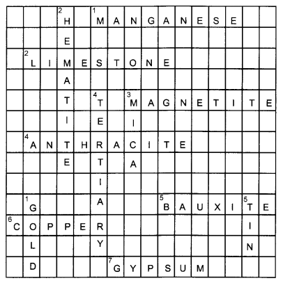
Fill the name of the correct mineral in the crossword below :
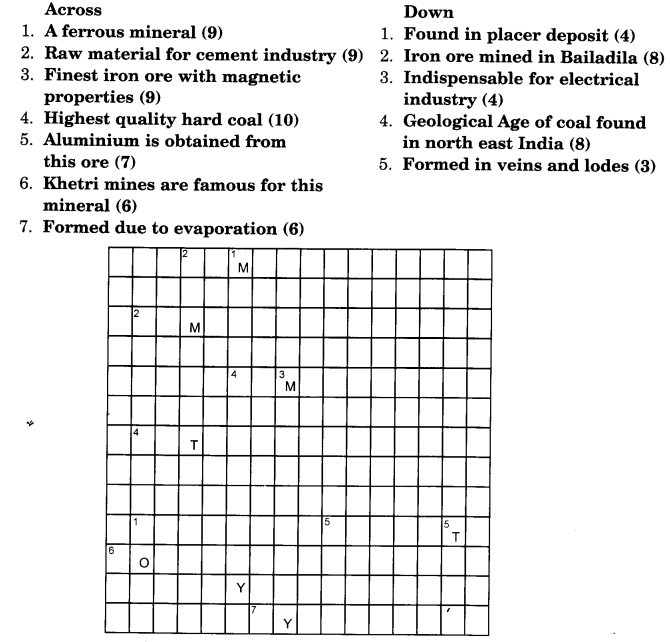
NCERT Solutions for Class 10 Social Science Geography Chapter 5 Minerals and Energy Resources 1

Answer:
Across

  1. Manganese
  2. Limestone
  3. Magnetite
  4. Anthracite
  5. Bauxite
  6. Copper
  7. Gypsum

Down

  1. Gold
  2. Hematite
  3. Mica
  4. Tertiary
  5. Tin

NCERT Solutions for Class 10 Social Science Geography Chapter 5 Minerals and Energy Resources 2 (2)

We hope the NCERT Solutions for Class 10 Social Science Geography Chapter 5 Minerals and Energy Resources help you. If you have any query regarding NCERT Solutions for Class 10 Social Science Geography Chapter 5 Minerals and Energy Resources, drop a comment below and we will get back to you at the earliest.

NCERT Solutions for Class 10 Social Science Geography Chapter 4 Agriculture

NCERT Solutions for Class 10 Social Science Geography Chapter 4 Agriculture

These Solutions are part of NCERT Solutions for Class 10 Social Science. Here we have given NCERT Solutions for Class 10 Social Science Geography Chapter 4 Agriculture.

TEXTBOOK EXERCISES

Question 1.
(a) Describe any two features of Intensive Subsistence Farming.
(b) Which are rabi crops? Mention any two.
(c) What do you understand by leguminous crops?
(d) What is the Minimum Support Price of a crop?
Answer:
(a)

  • It is labour intensive farming.
  • High doses of biochemical inputs and irrigation are used for obtaining higher production.

(b) Crops sown in winter from October to December and harvested in summer from April to June are Rabi crops,

  • Wheat
  • Mustard.

(c) A crop that helps in restoring soil fertility by fixing nitrogen from the air.
(d) Minimum Support Price is the price at which FCI procures food grains from the farmers.

Question 2.
Answer the following questions in 30 words :
(1) Name one important beverage crop and specify the geographical conditions required for its growth.
(2) Name one staple crop of India and the regions where it is produced.
(3) Enlist the various institutional reform programmes introduced by the government in the interest of farmers.
(4) The land under cultivation has got reduced day by day. Can you imagine its consequences?
Answer:
(1)
1. Important Beverage Crop and Conditions for its Growth: Tea is an important beverage crop. It is also a classic example of plantation agriculture.
2.The geographical conditions required for the growth of tea are as mentioned below :

  1. The tea plants grow well in tropical and sub-tropical climates endowed with deep and fertile well-drained soil, rich in humus and organic matter,
  2. The ideal temperature for its growth is 20 °C to 30 °C and an annual rainfall of 150 cm to 300 cm.
  3. Tea bushes require warm and moist frost-free climate all through the year,
  4. Frequent showers evenly distributed over the year ensure continuous growth of tender leaves,
  5. Tea is a labour-intensive crop. It requires abundant, cheap and skilled labour.
  6. Tea is processed within the tea garden to restore its freshness,
  7. Assam, hills of Darjeeling and Jalpaiguri districts, West Bengal, Tamil Nadu and Ketala are the leading tea-producing states,
  8. India is the leading producer as well as exporter of the tea in the world.

(2)

  1. Rice is one of the main staple food crops in India,
  2. It is grown in the plains of north and north-eastern India, coastal areas and the deltaic regions i.e., West Bengal, Uttar Pradesh, Andhra Pradesh, Punjab and Tamil Nadu,
  3. In Punjab, Haryana, parts of Rajasthan and western Uttar Pradesh, it is grown with the help of irrigation with canals and tubewells.

(3)
Institutional reform programmes : India is an agriculture-based country. Agriculture provides livelihood for more than 60 per cent of its population. However lack of techno- institutional changes have hindered the pace of agricultural development.
Thus collectivisation, consolidation of small holdings, cooperation and abolition of zamindari were given priority to bring about institutional reforms as mentioned below :
(1) Land reforms’ was the main focus of the First Five Year Plan. But these laws were not implemented properly. Thus, the Govt, of India embarked upon introducing agricultural reforms to improve Indian agriculture in the 1960s and 1970s.

(2)
The Green Revolution based on the use of package technology and the White Revolution
(Operation Flood) were the strategies initiated to improve the agriculture. But this led to the concentration of development in few selected areas.

(3) Thus in the 1980s and 1990s, a comprehensive land development programme was initiated, which included both institutional and technical reforms as mentioned below :

  1. Provision for crop insurance against drought, flood, cyclone, fire and disease was introduced.
  2. Grameen banks, cooperative societies and banks for providing loan facilities to the farmers at lower rates of interest were established.
  3. Kissan Credit Card (KCC), Personal Accident Insurance Scheme (PAIS) were introduced for the benefit of the farmers.
  4. Special weather bulletins for farmers were introduced on radio and television. Agricultural programmes were also introduced.
  5. The government announces minimum support price, remunerative and procurement prices for important crops to check the exploitation of farmers by speculators and middlemen. It ensures minimum price for the crop grown by the farmers.
  6. Land under cultivation has got reduced day by day.

Causes :

  1. The competition of land between non-agricultural uses such as industry, housing etc. and agriculture has resulted in reduction in the net sown area.
  2. The productivity of land has started showing a declining trend. Fertilisers etc. which were responsible for green revolution are not responsible for degrading the soils.
  3. Periodic scarcity of water has led to reduction in the area under irrigation.
  4. Inefficient water management has led to water logging and salinity.
  5. There has been a gradual shift from cultivation of food crops and cultivation of fruits vegetables, oil seeds and industrial crops.

Consequences : It has the following consequences :

  1. This has led to the reduction in net sown area under cereals and pulses.
  2. With the growing population of India, the declining food production may create a problem over country’s future food security.

Question 3.
Answer the following questions in about 120 words :
(1) Suggest the initiative taken by the government to ensure the increase in agricultural production.
(2) Describe the impact of globalisation on Indian agriculture.
(3) Describe the geographical conditions required for the growth of rice.
Answer:
(1) The government took the following steps to ensure increase in agricultural production :

  1. The strategies of package technology and the White Revolution (Operation Flood) were initiated to increase agricultural production,
  2. Provision for crop insurance, establishment of Grameen banks, cooperative societies for providing loan facilities to the farmers at lower rates of interest,
  3. In addition to above the Government ofUndia made efforts to modernise agriculture. Establishment of Indian Council of Agricultural Research (ICAR), agricultural universities, veterinary services and animal breeding centers, horticulture development, research and development in the field of meteorology and weather forecast were given priority for improving agriculture,
  4. The rural infrastructure was also improved.

(2) The impact of globalisation on Indian agriculture. (Deleted)

(3) Geographical conditions for the growth of rice :

  1. It is a Kharif crop which requires high temperature, (above 25 °C) and high humidity with annual rainfall above 100 cm.
  2. In the areas of less rainfall, it grows with the help of irrigation. For example, the development of dense network of canal irrigation and tubewells have made it possible to grow rice in Punjab, Haryana, western Uttar Pradesh and parts of Rajasthan.

Question 4.
Solve the puzzle by following your search horizontally and vertically to find the hidden answers :
1. The two staple food crops of India.
2. This is the summer cropping season of India.
3. Pulses like arhar, moong, gram, urad contain………………..
4. It is a coarse grain.
5. The two important beverages in India are …………………..
6. One of the four major fibres grown on black soils.
NCERT Solutions for Class 10 Social Science Geography Chapter 4 Agriculture 1
Answer:

  1. Rice and wheat
  2. Kharif
  3. Protein
  4. Jowar
  5. Tea and coffee
  6. Cotton.

We hope the NCERT Solutions for Class 10 Social Science Geography Chapter 4 Agriculture help you. If you have any query regarding NCERT Solutions for Class 10 Social Science Geography Chapter 4 Agriculture, drop a comment below and we will get back to you at the earliest.

NCERT Solutions for Class 10 Social Science Geography Chapter 3 Water Resources

NCERT Solutions for Class 10 Social Science Geography Chapter 3 Water Resources

These Solutions are part of NCERT Solutions for Class 10 Social Science. Here we have given NCERT Solutions for Class 10 Social Science Geography Chapter 3 Water Resources.

TEXTBOOK EXERCISES

Question 1.
(1) Based on the information given below classify each of the situations as ‘suffering from water scarcity’ or ‘not suffering from water scarcity’.
(a) Region with high annual rainfall.
(b) Region having high annual rainfall and large population.
(c) Region having high annual rainfall but water is highly polluted.
(d) Region having low rainfall and low population.
(2) Give an argument in favour of multi-purpose river projects.
Answer:
(1)
(a) Not suffering from water scarcity.
(b) Not suffering from water scarcity.
(c) Suffering from water scarcity.
(d) Suffering from water scarcity.

(2) Multi-purpose projects generate electricity for industries and homes. For example, in the Satluj-Beas river basin, the Bhakra-Nangal project water is being used both for hydel power production and irrigation.

Question 2.
Answer the following questions in about 30 words :
(1) Explain how water becomes a renewable resource.
(2) What is water scarcity and what are its main causes ?
(3) Compare the advantages and disadvantages of multi-purpose river projects.
Answer:
(1)

Water becomes a renewable resource by hydrological cycle. The fresh water which is
only a small proportion of water available on earth is mainly obtained from surface run off and groundwater that is continually being renewed and recharged through the hydrological cycle. Thus, all water-precipitations, surface run off and groundwater that moves within the hydro-logical cycle ensures that water is a renewable resource.

(2)

1.  Water scarcity implies water-shortage in low rainfall regions or drought prone areas. It is related to availability of bad quality of water as well. For example, in Rajasthan we see women balancing many ‘Matkas’ (earthen pots) used for collecting and storing water and travelling long distances to get water. The availability of water resources varies over space and time, mainly due to variations in seasonal and annual precipitation. Thus, it implies shortage of water in comparison to its demand in an area.

2. The main causes of scarcity of water are mentioned below :

  1. Increase in population : The water scarcity is an outcome of large and growing population that needs more water for domestic use as well as to produce more food. This leads to over-exploitation of water resources to expand irrigated areas and dry-season agriculture. More tubewells for irrigation leads to falling groundwater levels, adversely affecting water availability.
  2. Intensive industrialisation : In post independent India, there has been intensive industrialisation. More industries means need for more water and more power to run them. As such to meet the requirement, energy is produced from hydroelectric power. Thus, industriali-sation has led to more consumption of water. In India, hydroelectric power contributes 22 per cent of the total electricity produced.
  3. Urbanisation : Multiplying urban centers with large and dense populations and urban life-styles have not only added to water and energy requirements but have further aggravated the problem. People have their own groundwater pumping devices to meet their water needs. This leads to over-exploitation and depletion in the cities.
  4. Bad quality of water too leads to scarcity of water. There may be sufficient water in an
    area but it may be polluted by domestic and industrial wastes, chemicals, pesticides and fertilisers used in agriculture, thus, making it unsafe for human use.
  5. Unequal access to water among different social groups : Some time, the poor people in Jhuggi-Jhopri colonies may not get water for their use. The well-to-do people in their colonies may get water. This policy of discrimination of unequal access to water leads to scarcity of water for poor people, particularly in metropolitan Uties.

(3) Advantages and disadvantages of multi-purpose projects :
(1) Advantages:

  1. Dams built under the multi-purpose projects help to irrigate agricultural fields.
  2. Multi-purpose projects help in the generation of electricity. For example the Bhakra- Nangal project is being used both for hydel power production and irrigation.
  3. It provides water supply for industry and domestic use.
  4. It helps to control floods. For example, the Hirakud project in the Mahanadi basin integrates conservation of water with flood control.
  5. These places have become places of recreation for the people.
  6. These projects are used for inland navigation.
  7. These projects have helped in fish breeding.
  8. In view of the above advantages, the multi-purpose projects were thought of as the vehicle that would lead the nation to development and progress. Jawaharlal Nehru proudly proclaimed the dams as the “temples of modern India” because it would integrate the development of agriculture and the village economy with rapid industrialization and growth of the urban economy.

(2) Disadvantages :

  1. It affects the natural flow of the river causing poor sediment flow and excessive sedimentation at the bottom of the reservoir resulting in rockier stream beds and poorer habitats for the rivers’ aquatic life.
  2. Dams fragment rivers making it difficult for aquatic fauna to migrate, especially for spawning.
  3. The reservoirs that are created on the floodplains submerge the existing vegetation and soil leading to its decomposition over a period of time.
  4. These projects lead to large-scale displacement of local communities who have to give up their land and livelihood. This in turn led to social movements like the ‘Narmada Bachao Andolan’ and ‘Tehri Dam Andolan’. Local people often had to give up their land, livelihood and their meagre access and control over resources for the greater good of the nation. The local people i.e., landless labourers do not get any benefit from such projects.
  5. With irrigation facilities the farmers have changed their crops to water-intensive and commercial crops. This has great ecological consequences like salinisation of the soil.
  6. It has transformed the social landscape i.e., increased the social gap between the
    richer landowners and the landless poor.
  7. It has led to conflicts between people wanting different uses and benefits from the same water resources as has happened in Gujarat. Where the Sabarmati basin farmers were agitated and almost caused a riot over higher priority given to water supply in urban areas, particularly during droughts.
  8. Multi-purpose projects have led to interstate water disputes that are becoming common with regard to sharing the costs and benefits of these projects.

Question 3.
Answer the following questions in about 120 words :
(1) Discuss how rainwater harvesting in semi-arid regions of Rajasthan is
carried out.
(2) Describe how modern adaptations of traditional rainwater harvesting meth¬ods are being carried out to conserve and store water.
Answer:
(1)

  1. In the semi-arid and arid regions of Rajasthan, particularly in Bikaner, Phalodi and Barmer, almost all the houses
  2. traditionally had underground tanks or tankas for storing drinking water.
  3. The tanks could be as large as a big room.
  4. One household in Phalodi had a tank that was 6.1 meters deep, 4.27 meters long and 2.44 meters wide.
  5. These tankas were part of the well developed rooftop rainwater harvesting system.
  6. These were built inside the main house or the courtyard. They were connected to the sloping roofs of the houses through a pipe.
  7. Rain falling on the rooftops would travel down the pipe and was stored in these underground ‘tankas’.
  8. The first spell of rain was usually not collected as this would clean the roofs and the pipes. The rainwater from the subsequent showers was then collected.
  9. The rainwater is stored in the tankas till the next rainfall.
  10. It is the most reliable source of drinking water when all other sources are dried up, particularly in the summers.
  11. Rainwater called as ‘palar pani’ is considered the purest form of natural water. Not only this, many houses construct underground rooms adjoining the ‘tanka’ to beat the summer heat as it would keep the room cool.
    However, the practice of rooftop rainwater harvesting is on the decline due to the perennial Rajasthan Canal which has made the availability of plenty of water in the area.

(2) Modern adaptations of traditional rainwater harvesting methods are being carried out in many parts of the country to conserve and store water as mentioned below :

  1. In Gendathur village in Mysore, Karnataka, nearly 200 households have installed the system of rainwater harvesting.
  2. Gendathur receives an annual precipitation of 1,000 mm, and with 80 per cent of collection efficiency and of about 10 fillings, every house can collect and use 50,000 liters of water annually.
  3. From the 20 houses, the net amount of rainwater harvested annually comes to 1,00,000 liters. Thus, the rainwater harvesting system is being carried out successfully in Gendathur which has earned the rare distinction of being rich in rainwater.
  4. In addition to Gendathur, Tamil Nadu is the first and the only state in India which had made rooftop rainwater harvesting structure compulsory to all the houses across the state. There are legal provisions to punish the defaulters.
    Thus, modern adaptations of traditional rainwater harvesting methods are being carried out to conserve and store water.
  5. In Meghalaya, a 200-year-old system of tapping stream and spring water by using
    bamboo pipes, is prevalent. About 18-20 liters of water enters the bamboo pipe system, gets transported over hundreds of meters, and finally reduces to 20-80 drops per minute at the site of the plant.

We hope the NCERT Solutions for Class 10 Social Science Geography Chapter 3 Water Resources help you. If you have any query regarding NCERT Solutions for Class 10 Social Science Geography Chapter 3 Water Resources, drop a comment below and we will get back to you at the earliest.

RS Aggarwal Solutions Class 10 Chapter 9 Mean, Median, Mode of Grouped Data Ex 9a

RS Aggarwal Solutions Class 10 Chapter 9 Mean, Median, Mode of Grouped Data, Cumulative Frequency Graph and O give Ex 9a

These Solutions are part of RS Aggarwal Solutions Class 10. Here we have given RS Aggarwal Solutions Class 10 Chapter 9 Mean, Median, Mode of Grouped Data,Cumulative Frequency Graph and O give Ex 9a.

Other Exercises

Question 1.
Solution:
RS Aggarwal Solutions Class 10 Chapter 9 Mean, Median, Mode of Grouped Data Ex 9a 1

Question 2.
Solution:
RS Aggarwal Solutions Class 10 Chapter 9 Mean, Median, Mode of Grouped Data Ex 9a 2

Question 3.
Solution:
RS Aggarwal Solutions Class 10 Chapter 9 Mean, Median, Mode of Grouped Data Ex 9a 3

Question 4.
Solution:
We have
RS Aggarwal Solutions Class 10 Chapter 9 Mean, Median, Mode of Grouped Data Ex 9a 4

RS Aggarwal Solutions Class 10 Chapter 9 Mean, Median, Mode of Grouped Data Ex 9a 5

Question 5.
Solution:
We have
RS Aggarwal Solutions Class 10 Chapter 9 Mean, Median, Mode of Grouped Data Ex 9a 6

Question 6.
Solution:
We have
RS Aggarwal Solutions Class 10 Chapter 9 Mean, Median, Mode of Grouped Data Ex 9a 7

Question 7.
Solution:

RS Aggarwal Solutions Class 10 Chapter 9 Mean, Median, Mode of Grouped Data Ex 9a 8

Question 8.
Solution:
RS Aggarwal Solutions Class 10 Chapter 9 Mean, Median, Mode of Grouped Data Ex 9a 9

Question 9.
Solution:
RS Aggarwal Solutions Class 10 Chapter 9 Mean, Median, Mode of Grouped Data Ex 9a 10

Question 10.
Solution:
RS Aggarwal Solutions Class 10 Chapter 9 Mean, Median, Mode of Grouped Data Ex 9a 11

Question 11.
Solution:
RS Aggarwal Solutions Class 10 Chapter 9 Mean, Median, Mode of Grouped Data Ex 9a 12

Question 12.
Solution:
RS Aggarwal Solutions Class 10 Chapter 9 Mean, Median, Mode of Grouped Data Ex 9a 13

Question 13.
Solution:
We have
7+f1+12+f2+8+5=50 ⇒ f2= 18-f1
RS Aggarwal Solutions Class 10 Chapter 9 Mean, Median, Mode of Grouped Data Ex 9a 14

RS Aggarwal Solutions Class 10 Chapter 9 Mean, Median, Mode of Grouped Data Ex 9a 15

Question 14.
Solution:
RS Aggarwal Solutions Class 10 Chapter 9 Mean, Median, Mode of Grouped Data Ex 9a 16

Question 15.
Solution:
We have, Let A = 25 be the assumed mean
RS Aggarwal Solutions Class 10 Chapter 9 Mean, Median, Mode of Grouped Data Ex 9a 17
Hence mean = 28.

Question 16.
Solution:
Let the assumed mean be 150, h = 20
RS Aggarwal Solutions Class 10 Chapter 9 Mean, Median, Mode of Grouped Data Ex 9a 18
Hence, Mean = 146.25.

Question 17.
Solution:
Let A = 50 be the assumed mean, we have
RS Aggarwal Solutions Class 10 Chapter 9 Mean, Median, Mode of Grouped Data Ex 9a 19

Question 18.
Solution:
RS Aggarwal Solutions Class 10 Chapter 9 Mean, Median, Mode of Grouped Data Ex 9a 20

Question 19.
Solution:

RS Aggarwal Solutions Class 10 Chapter 9 Mean, Median, Mode of Grouped Data Ex 9a 21

Question 20.
Solution:
RS Aggarwal Solutions Class 10 Chapter 9 Mean, Median, Mode of Grouped Data Ex 9a 22

Question 21.
Solution:
RS Aggarwal Solutions Class 10 Chapter 9 Mean, Median, Mode of Grouped Data Ex 9a 23


Question 22.
Solution:
RS Aggarwal Solutions Class 10 Chapter 9 Mean, Median, Mode of Grouped Data Ex 9a 24

Question 23.
Solution:

RS Aggarwal Solutions Class 10 Chapter 9 Mean, Median, Mode of Grouped Data Ex 9a 25

Question 24.
Solution:
RS Aggarwal Solutions Class 10 Chapter 9 Mean, Median, Mode of Grouped Data Ex 9a 26

Question 25.
Solution:
Let h = 20 and assume mean = 550, we prepare the table given below:
RS Aggarwal Solutions Class 10 Chapter 9 Mean, Median, Mode of Grouped Data Ex 9a 27

RS Aggarwal Solutions Class 10 Chapter 9 Mean, Median, Mode of Grouped Data Ex 9a 28
Hence the mean of the frequency distribution is 544.

Question 26.
Solution:
The given series is an inclusive series, making it an exclusive series, we have
RS Aggarwal Solutions Class 10 Chapter 9 Mean, Median, Mode of Grouped Data Ex 9a 29
RS Aggarwal Solutions Class 10 Chapter 9 Mean, Median, Mode of Grouped Data Ex 9a 30

Question 27.
Solution:
The given series is an inclusive series making it an exclusive series,we get
RS Aggarwal Solutions Class 10 Chapter 9 Mean, Median, Mode of Grouped Data Ex 9a 31

RS Aggarwal Solutions Class 10 Chapter 9 Mean, Median, Mode of Grouped Data Ex 9a 32
Hence, Mean = 34.87 years.

Question 28.
Solution:
RS Aggarwal Solutions Class 10 Chapter 9 Mean, Median, Mode of Grouped Data Ex 9a 33

Question 29.
Solution:
RS Aggarwal Solutions Class 10 Chapter 9 Mean, Median, Mode of Grouped Data Ex 9a 34

We hope the RS Aggarwal Solutions Class 10 Chapter 9 Mean, Median, Mode of Grouped Data Ex 9a help you. If you have any query regarding RS Aggarwal Solutions Class 10 Chapter 9 Mean, Median, Mode of Grouped Data Ex 9a, drop a comment below and we will get back to you at the earliest

NCERT Solutions for Class 10 Social Science Geography Chapter 1 Resource and Development

NCERT Solutions for Class 10 Social Science Geography Chapter 1 Resource and Development

These Solutions are part of NCERT Solutions for Class 10 Social Science. Here we have given NCERT Solutions for Class 10 Social Science Geography Chapter 1 Resource and Development.

TEXTBOOK EXERCISES

Question 1.
(a) What type of resource is iron ore?
(b) Which is a replenishable type of resource?
(c) State one cause of land degradation in Punjab.
(d) In which state is terrace cultivation practised?
(e) Mention one state where black soil is found.
Answer:
(a) Non-renewable.
(b) Tidal energy.
(c) Intensive cultivation.
(d) Uttarakhand.
(e) Gujarat.

Question 2.
Answer the following questions in about 30 words :

  1. Name three states having black soil and the crop which is mainly grown in it.
  2. What type of soil is found in the river deltas of the eastern coast? Give three main features of this type of soil.
  3. What steps can be taken to control soil erosion in the hilly areas?
  4. What are the biotic and abiotic resources? Give some examples.

Answer:
(1) The states of Maharashtra, Madhya Pradesh and Chhattisgarh have black soil. The crop which is mainly grown in this soil is cotton. This soil is also called ‘Regur’ or black cotton soil.

(2) The river deltas of the eastern coast have alluvial soil.
Alluvial soil consists of various proportions of sand, silt, and clay.
The main features of alluvial soil are:

  • These soils are very fertile and so ideal for cultivation.
  • They contain adequate quantities of potash, phosphoric acid and lime good for the growth of sugarcane, paddy, and other crops.
  • In drier areas, these soils are more alkaline.

(3) In hilly areas, soil erosion can be controlled by contour ploughing which is ploughing along contour-lines, using terrace farming techniques, and using strips of grasses to check soil erosion by wind and water.

(4) Biotic Resources: The resources which are obtained from the biosphere and have life are called Biotic Resources. Examples of biotic resources are animals, plants, human beings, fish, livestock, etc.
Abiotic Resources: The resources which are composed of non-living things are called Abiotic Resources.
Examples of abiotic resources are water, minerals, metals, wind, solar energy, etc.

Question 3(1).
Answer the following questions in about 120 words :

(1) Explain land use pattern in India and why has the land under forest not increased much since
1960-61.
Answer:
(1) The land use for different purposes in the year 1960-61 and 2002-03 is as given B below:
NCERT Solutions for Class 10 Social Science Geography Chapter 1 Resource and Development 1

(2) On the basis of the above chart and other facts available, the main features of the land use pattern in India are as mentioned below :

  • The total geographical area of India is 3.28 million sq. km.
  • Land use data, however, is available only for 93 percent of the total area because the land use reporting for most of the north-east states except Assam has not been done fully. Moreover, some areas of Jammu and Kashmir occupied by Pakistan and China have also not been surveyed.

(3) The land under permanent pasture has decreased.
(4) The pattern of the net sown area varies greatly from one state to another. It is over 80 per tent of the total area in Punjab and Haryana and less than 10 percent in Arunachal Pradesh, Mizoram, Manipur, and Andaman Nicobar Islands.
(5) The land under forest has changed a little from 18.11% in 1960-61 to 22.57% in 2002-03. It is still far lower than the desired 33 percent of the geographical area as it was outlined in the National Forest Policy (1952). Land under forest has not increased due to various factors, namely, agricultural expansion, large-scale development projects or river valley projects, grazing and fuel collection.
(6) A part of the land is termed as wasteland and land put to other non-agricultural uses.

Question 3(2).
How has technical and economic development led to more consumption of resources?
Answer:
Technical and economic development has led to more consumption of resources due to reasons as mentioned below :

  1. Higher level of technological development needs more and more resources for production activities.
  2. As Gandhiji said the exploitative nature of modem technology is the root cause of resource depletion at the global level.
  3. It was primarily the higher level of technological development of the colonising countries that helped them to exploit resources of other regions and establish their supremacy over the colonies. Thus resources can contribute to development only when they are accompanied by appropriate technological development and institutional changes. India has experienced all this in different phases of colonisation.
    Thus, it is true that technical and economic development leads to more consumption of resources. Water resources are being exploited to expand the irrigated areas and dry season agriculture. As the result as in the case of Punjab and Haryana, the water level has gone down creating problems for the farmers.

Question 4.
Imagine if oil supplies get exhausted, how will this affect our lifestyle?
Answer:

  1. If oil supplies get exhausted, the world would come to a halt. People would end up living wherever they were. There will be no more planes, operating boats and trains.
  2. Pricing for any transportation would be out of reach but for the richest for a limited period.
  3. We would be limited to existing supplies of coal, natural gas, etc.
  4. A lot of jobs would be lost because many factories, restaurants, etc. would be shut down.
  5. Many would leave cities to live in rural areas.
  6. Cities would become ghost towns. There may be killed in order to control the necessary things needed for survival in the world. We would not only lose our lifestyle but lose contact with the whole world. However, as scientists are doing research to find out alternative sources of energy, it is hoped that they would be successful in their efforts. They may be able to use solar or wind energy in place of petroleum products and in that case, if the oil supplies get exhausted, it would not make any difference in our lives. Perhaps, life would become better in the future.

Question 5.
Solve the puzzle by following your search horizontally and vertically to find the hidden answers.
NCERT Solutions for Class 10 Social Science Geography Chapter 1 Resource and Development 2

  1. Natural endowments in the form of land, water, vegetation and minerals.
  2. A type of non-renewable resource.
  3. Soil with high water retaining capacity.
  4. Intensively leached soils of the monsoon climate.
  5. Plantation of trees on a large scare to check soil erosion.
  6. The Great Plains of India are made up of these soils.

Answer:

  1. Resource
  2. Minerals
  3. Laterite
  4. Black
  5. Afforestation
  6. Alluvial.

We hope the NCERT Solutions for Class 10 Social Science Geography Chapter 1 Resource and Development help you. If you have any query regarding NCERT Solutions for Class 10 Social Science Geography Chapter 1 Resource and Development, drop a comment below and we will get back to you at the earliest.